- New York State Route 33A
-
NYS Route 33A
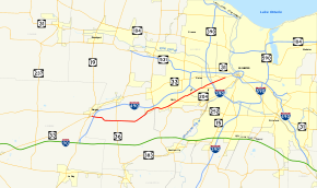
Map of Rochester with NY 33A highlighted in redRoute information Auxiliary route of NY 33 Maintained by NYSDOT and the city of Rochester Length: 17.15 mi[2] (27.60 km) Existed: 1930[1] – present Major junctions West end:  NY 33 in Bergen
 I-390 in Gates
East end: NY 33 in RochesterLocation Counties: Genesee, Monroe Highway system Numbered highways in New York
Interstate • U.S. • N.Y. (former) • Reference • County← NY 33NY 34  →
→New York State Route 33A (NY 33A) is an east–west state highway mostly located in Monroe County, New York, in the United States. The route is just over 17 miles (27 km) long and serves as an alternate route of NY 33 between the town of Bergen in Genesee County and the city of Rochester in Monroe County. While NY 33 heads to Rochester by way of Churchville and northern Gates, NY 33A dips south to pass through Chili and southern Gates. NY 33A was assigned as part of the 1930 renumbering of state highways in New York, but only from Riga to Rochester. It was extended westward to its current terminus in Bergen ca. 1932.
Contents
Route description
West of Gates
NY 33A begins at an intersection with NY 33 just east of the village of Bergen in the town of the same name. From this point, NY 33 travels to the west and to the northeast while NY 33A heads east. Less than a quarter of a mile (0.4 km) from its western terminus, NY 33A meets Interstate 490 (I-490) at exit 2. In this area, I-490 straddles the border between Genesee County and Monroe County; thus, the westbound portion of the interchange is in Genesee County while the eastbound half is in Monroe County.[3]
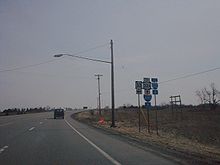 The western terminus of NY 33A as seen from NY 33 eastbound.
Now in the town of Riga, NY 33A becomes Chili – Riga Center Road as it traverses a largely rural portion of southwestern Monroe County. In the small hamlet of Riga, the route intersects and briefly overlaps with NY 36. East of Riga hamlet, NY 33A heads generally northeastward, passing by Black Creek Park as it enters the town of Chili. Just west of the hamlet of West Chili, the route crosses over Black Creek and intersects Chili Avenue Extension. At this junction, NY 33A becomes Chili Avenue, the name it retains into the city of Rochester. Locally, the Chili Avenue name is used more in common parlance than the NY 33A designation.[3]
In West Chili, the route meets the southern terminus of NY 259. The route continues on, heading northeastward into more densely populated areas of the town of Chili. About 1.5 miles (2.4 km) east of West Chili, NY 33A intersects the western terminus of NY 252. Not far to the northeast, the highway meets NY 386, which joins NY 33A for one mile (1.6 km) to Chili Center, Chili's main commercial hub. Here, NY 386 splits off to the north at a junction that also serves as the western terminus of NY 252A. Past Chili Center, NY 33A heads northeast through a residential neighborhood and into the town of Gates.[3]
Gates and Rochester
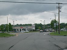
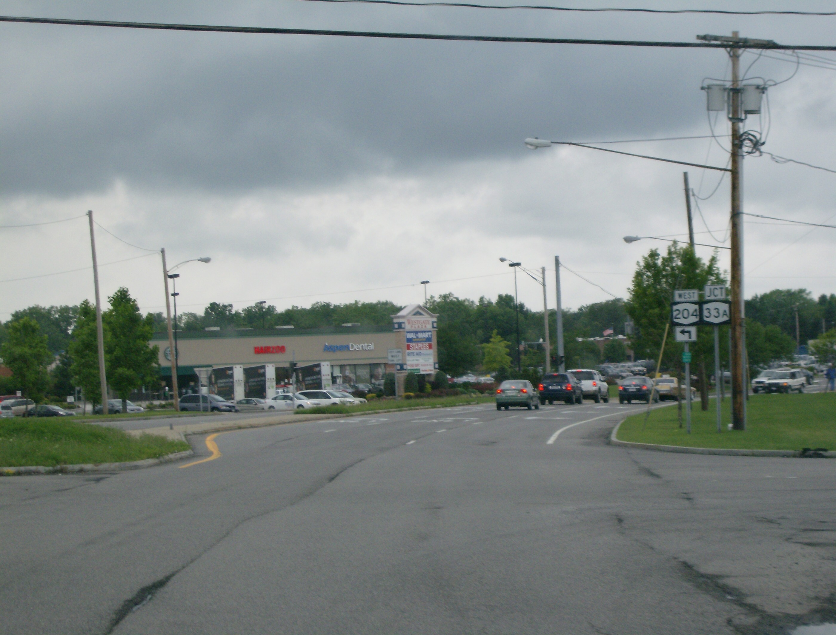
Just across the town line, NY 33A intersects the east end of the Airport Expressway (NY 204). At this point, NY 204 leaves the highway and turns to follow NY 33A eastward. While most of NY 33A west of Gates is a two-lane highway, the portion of Chili Avenue that carries both NY 33A and NY 204 is a four-lane roadway. The two routes soon enter Tressmar, a hamlet that has been transformed into a major commercial destination. The development is mostly centered around Westgate Plaza, a large shopping plaza anchored by a Wal-Mart. As NY 33A passes south of the plaza, it connects to Howard Road[3] (unsigned NY 940L and formerly part of NY 47[4][5]) and Brooks Avenue. NY 204 leaves NY 33A at Brooks Avenue to follow the road eastward toward the Greater Rochester International Airport.[3]
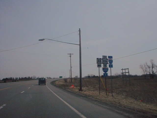
 Approaching NY 33A on NY 204 westbound
East of Brooks Avenue, NY 33A passes through a small residential area before entering a more industrial neighborhood surrounding the Erie Canal and the Rochester city line. In the western portion of this area, the route meets I-390 at exit 19 and intersects Buell Road, a county-maintained highway that directly links NY 33A to the airport a half-mile (0.8 km) to the south. East of I-390, NY 33A crosses the Erie Canal and enters the city of Rochester,[3] at which point maintenance of NY 33A shifts from the New York State Department of Transportation (NYSDOT) to the city of Rochester.[6] On the northern bank of the waterway, the route passes under the Rochester and Southern Railroad. The surroundings become significantly more residential east of the railroad as the route heads northeastward toward downtown Rochester. However, NY 33A ends roughly one mile (1.6 km) west of downtown at a junction with NY 33 (West Avenue). Here, Chili and West Avenues converge and NY 33 continues toward downtown as West Main Street.[3]
History
In 1908, the New York State Legislature created Route 16, an unsigned legislative route extending from the Southern Tier village of Cuba to the city of Rochester just south of Lake Ontario.[7] Route 16 entered the Rochester area on what is now NY 386 and followed modern NY 386, Old Scottsville–Chili Road, and Chili Avenue northeastward to the Rochester city line. From there, the route continued for an additional 1 mile (1.6 km) to the original city limits, where it ended near the intersection of Chili Avenue and Post Street.[8] On March 1, 1921, Route 16 was truncated to end in Le Roy while the portion of its former alignment north of Caledonia became part of an extended Route 15.[9]
When the first set of posted routes in New York were assigned in 1924, the segment of legislative Route 15 north of Caledonia was not assigned a designation.[10] Within two years, a highway extending from Batavia to Rochester by way of Bergen and Gates was designated as NY 33. However, NY 33 followed a more northerly routing through Gates than old Route 15 did as it used Buffalo Road instead of Chili Avenue.[11] In the 1930 renumbering of state highways in New York, the Chili Avenue portion of legislative Route 15 became part of the new NY 33A, a then-spur route of NY 33 that began at NY 36 in Riga and ended at NY 33 in southwestern Rochester.[1] Ca. 1932, NY 33A was extended westward to the town of Bergen, where it reconnected to NY 33 southeast of the village of Bergen.[12][13]
Major intersections
County Location Mile[2] Destinations Notes Genesee Town of Bergen 0.00 NY 330.28  I-490
I-490Exit 2 (I-490) Monroe Riga 2.93  NY 36 north
Western terminus of NY 33A / NY 36 overlap 3.16 NY 36 southEastern terminus of NY 33A / NY 36 overlap Chili 7.91  NY 259
Southern terminus of NY 259 9.57  NY 252
Western terminus of NY 252 9.88  NY 386 south
Western terminus of NY 33A / NY 386 overlap 10.89  NY 252A / NY 386 north
Western terminus of NY 252A; eastern terminus of NY 33A / NY 386 overlap Gates 13.46  NY 204 west
Western terminus of NY 33A / NY 204 overlap 14.31 NY 204 eastEastern terminus of NY 33A / NY 204 overlap 15.41 I-390Exit 19 (I-390) Rochester 17.15 NY 331.000 mi = 1.609 km; 1.000 km = 0.621 mi References
- ^ a b Standard Oil Company of New York (1930). Road Map of New York (Map). Cartography by General Drafting.
- ^ a b "2008 Traffic Volume Report for New York State" (PDF). New York State Department of Transportation. June 16, 2009. p. 100. https://www.nysdot.gov/divisions/engineering/technical-services/hds-respository/NYSDOT%20TVR%202008%20by%20Route.pdf. Retrieved January 31, 2010.
- ^ a b c d e f g Google, Inc. Google Maps – overview map of NY 33A (Map). Cartography by Google, Inc. http://maps.google.com/maps?f=d&source=s_d&saddr=NY-33A&daddr=Chili+Riga+Center+Rd%2FNY-33A+to:Chili+Ave%2FNY-33A+to:43.1472346,-77.645308+to:NY-33%2FWest+Ave&hl=en&geocode=FVpEkQId7rta-w%3BFSJFkQIdCGlc-w%3BFebmkQId7AFe-w%3BFeJfkgIdBDpf-yn3_vEDm7TWiTFy9FX1VXz3wA%3BFbBqkgIdSlhf-w&mra=dpe&mrcr=2&mrsp=3&sz=16&via=3&sll=43.148812,-77.648599&sspn=0.011115,0.027831&ie=UTF8&t=h&z=16. Retrieved July 19, 2009.
- ^ New York State Department of Transportation (January 2009) (PDF). Official Description of Highway Touring Routes, Bicycling Touring Routes, Scenic Byways, & Commemorative/Memorial Designations in New York State. https://www.nysdot.gov/divisions/operating/oom/transportation-systems/repository/2009%20tour-bk.pdf. Retrieved July 19, 2009.
- ^ Esso (1938). New York Road Map for 1938 (Map). Cartography by General Drafting.
- ^ New York State Department of Transportation (1997). Rochester West Digital Raster Quadrangle (Map). 1:24,000. http://www.nysgis.state.ny.us/gisdata/quads/drg24/dotpreview/index.cfm?code=o17. Retrieved July 26, 2009.
- ^ State of New York Department of Highways (1909). The Highway Law. Albany, New York: J. B. Lyon Company. pp. 59–60. http://books.google.com/books?id=jZ0AAAAAMAAJ&pg=PA59. Retrieved July 26, 2009.
- ^ New York State Department of Highways (1920). Report of the State Commissioner of Highways. Albany, New York: J. B. Lyon Company. p. 525. http://books.google.com/books?id=Sj4CAAAAYAAJ&pg=PA525. Retrieved July 26, 2009.
- ^ New York State Legislature (1921). "Tables of Laws and Codes Amended or Repealed". Laws of the State of New York passed at the One Hundred and Forty-Fourth Session of the Legislature. Albany, New York: J. B. Lyon Company. pp. 42, 56–57. http://books.google.com/books?id=6pE4AAAAIAAJ&pg=PA42. Retrieved June 6, 2010.
- ^ "New York's Main Highways Designated by Numbers". The New York Times: p. XX9. December 21, 1924.
- ^ State of New York Department of Public Works (1926). Official Map Showing State Highways and other important roads (Map). Cartography by Rand McNally and Company.
- ^ Kendall Refining Company (1931). New York (Map). Cartography by H.M. Gousha Company.
- ^ Texas Oil Company (1932). Texaco Road Map – New York (Map). Cartography by Rand McNally and Company.
External links
Categories:- State highways in New York
- Transportation in Genesee County, New York
- Transportation in Monroe County, New York


Wikimedia Foundation. 2010.