- County routes in New York
-
Part of the series on
Highways in New York
Interstate Highways 
U.S. Routes 
State routes (former) 
Reference routes 
County routes In the U.S. state of New York, county routes exist in all 62 counties except those in the five boroughs of New York City. Most are maintained locally by county highway departments. Although county route designations occasionally cross from one county to the next, such as County Route 36 in Ontario County and County Route 36A in Livingston County, such cases are rare in New York due to the lack of a statewide numbering system. Instead, county routes are assigned on the county level, resulting in numbering systems that vary by county. Some counties, such as Dutchess County, use a system in which county route numbers are assigned by town in alphabetical order while others like Monroe County assign numbers in a general west-to-east fashion.[1][2] Still others, for instance Livingston County, have no defined pattern.[3]
 MUTCD-standard shield for County Route 62 in Livingston County.
The method that each county employs to sign its routes varies from one county to the next. The majority of counties in New York use the MUTCD-standard blue pentagonal shield with yellow lettering. Others tweak this shield slightly, using white lettering instead of yellow (particularly in areas near the Capital District[4][5]) or using shapes similar to a pentagon. Additionally, Orange County employs a wide assortment of signage, ranging from the standard blue pentagonal shield to a blue diamond with white lettering.[6] On the other hand, some counties, such as Orleans County, do not post signage along their routes.[7]
Like the numbering system and the choice of signage, the complexity of the county highway system varies by county as well. Erie County, for example, one of the most urbanized counties in Upstate New York, maintains a system of nearly 400 routes.[8] In contrast, the Southern Tier county of Tioga manages only 29 roads.[9]
The highest-numbered posted county route and the only four-digit county route signed as such in the state, County Route 1345, resides in Saratoga County.[10]
Westchester County routes are typically unmarked, as the county government only loosely enforces the signage of county roads.
Contents
List of county routes by county

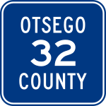
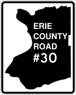 Examples of unorthodox county route signage in New York. Above: Wayne CR 143, an old shield for Otsego CR 32, and Erie CR 30. Most of Otsego County now uses the standard pentagon.
Albany to Greene Hamilton to Rensselaer Rockland to Yates - Albany County
- Allegany County
- Broome County
- Cattaraugus County
- Cayuga County
- Chautauqua County
- Chemung County
- Chenango County
- Clinton County
- Columbia County
- Cortland County
- Delaware County
- Dutchess County
- Erie County
- Essex County
- Franklin County
- Fulton County
- Genesee County
- Greene County
- Hamilton County
- Herkimer County
- Jefferson County
- Lewis County
- Livingston County
- Madison County
- Monroe County
- Montgomery County
- Nassau County
- Niagara County
- Oneida County
- Onondaga County
- Ontario County
- Orange County
- Orleans County
- Oswego County
- Otsego County
- Putnam County
- Rensselaer County
- Rockland County
- Saratoga County
- Schenectady County
- Schoharie County
- Schuyler County
- Seneca County
- St. Lawrence County
- Steuben County
- Suffolk County
- Sullivan County
- Tioga County
- Tompkins County
- Ulster County
- Warren County
- Washington County
- Wayne County
- Westchester County
- Wyoming County
- Yates County
History
Circa 1974, most of New York switched to the MUTCD-standard blue pentagon shield. Signs that predate this transition can still be found in certain areas of the state.[11]
References
- ^ Perry, N.W. "Dutchess County Routes". Empire State Roads. http://www.empirestateroads.com/cr/crdutchess.html. Retrieved April 1, 2010.
- ^ Perry, N.W. "Monroe County Routes". Empire State Roads. http://www.empirestateroads.com/cr/crmonroe.html. Retrieved April 1, 2010.
- ^ Perry, N.W. "Livingston County Routes". Empire State Roads. http://www.empirestateroads.com/cr/crlivingston.html. Retrieved April 1, 2010.
- ^ Lyons, Sean. "Fulton County". New York County Road Signs. http://www.gribblenation.net/nycosigns/fulton.htm. Retrieved April 1, 2010.
- ^ Lyons, Sean. "Greene County". New York County Road Signs. http://www.gribblenation.net/nycosigns/greene.htm. Retrieved April 1, 2010.
- ^ Lyons, Sean. "Orange County". New York County Road Signs. http://www.gribblenation.net/nycosigns/orange.htm. Retrieved April 1, 2010.
- ^ Perry, N.W. "Orleans County Routes". Empire State Roads. http://www.empirestateroads.com/cr/crorleans.html. Retrieved April 1, 2010.
- ^ Perry, N.W. "Erie County Routes". Empire State Roads. http://www.empirestateroads.com/cr/crerie.html. Retrieved April 1, 2010.
- ^ Perry, N.W. "Tioga County Routes". Empire State Roads. http://www.empirestateroads.com/cr/crtioga.html. Retrieved April 1, 2010.
- ^ Perry, N.W. "Saratoga County Routes". Empire State Roads. http://www.empirestateroads.com/cr/crsaratoga.html. Retrieved April 1, 2010.
- ^ Lyons, Sean. "Index". New York County Road Sign Gallery. http://www.gribblenation.net/nycosigns/index.html. Retrieved April 1, 2010.
External links
Categories:


Wikimedia Foundation. 2010.