- New York State Route 217
-
NYS Route 217

Map of Columbia County with NY 217 highlighted in redRoute information Maintained by NYSDOT Length: 6.78 mi[2] (10.91 km) Existed: 1930[1] – present Major junctions West end:  NY 23 in Claverack
 Taconic Parkway in Ghent
East end:  CR 21C in Ghent
Location Counties: Columbia Highway system Numbered highways in New York
Interstate • U.S. • N.Y. (former) • Reference • County←  NY 216
NY 218  →
→New York State Route 217 (NY 217) is a 6.78-mile (10.91 km) long state highway in Columbia County, New York, United States. It connects NY 23 in Claverack to the Taconic State Parkway in Ghent by way of the village of Philmont. The majority of NY 217 is a rural highway, excluding portions near the NY 23 junction and in Philmont.
NY 217 originally extended from Mellenville to NY 22 in the town of Hillsdale when it was assigned as part of the 1930 renumbering of state highways in New York. It was extended west to its present terminus in Claverack in the early 1930s. NY 217 was truncated westward to Harlemville in the mid-1930s, then to the Taconic Parkway in 1980. The former routing of NY 217 is now maintained by Columbia County as County Route 21 (CR 21) and County Route 21C.
Contents
Route description
NY 217
NY 217 begins at an intersection with NY 23 east of the hamlet of Claverack in the town of the same name in central Columbia County. The route heads northeastward from the intersection, passing by the historic Stephen Storm House at the outskirts of Claverack hamlet and into a rural portion of the town. At an intersection with Roxbury Road, NY 217 passes the Columbia Golf and Country Club to the west and begins to parallel Claverack Creek. NY 217 intersects with CR 18 (Fish and Game Road), then enters the populous hamlet of Mellenville.[3]
 NY 217 reaching its western terminus with NY 23 in Claverack. The terminus is out of view on the curve
In the center of Mellenville, NY 217 intersects with CR 9 (Mellenville Road), with NY 217 serving as CR 9's southern terminus. NY 217 then heads southeast, crossing Claverack Creek and passing Mellenville Union Cemetery to the north as well as the adjacent Claverack Town Park. The route turns eastward and meets the northern terminus of Roxbury Road as it enters the village of Philmont. Within Philmont, NY 217 follows Main Street through the center of the densely populated village. At an intersection with Maple Street, the highway comes within view of Summit Lake, a small water body in the center of Philmont. Past the lake, NY 217 turns northeast once more and intersects with CR 11 (Martindale Road) as it leaves the village.[3]
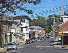 NY 217 crossing through downtown Philmont
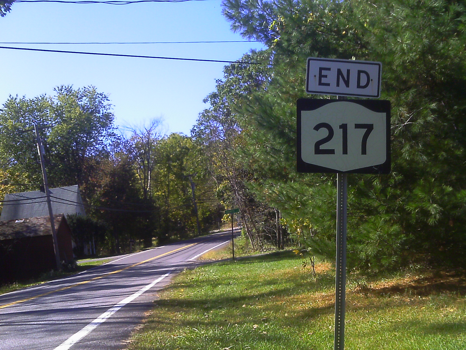
After Philmont, NY 217 progresses its way northeastward, with the highway winding its way through a mixture of dense woods and open fields. Shortly after crossing into the town of Ghent, the route turns eastward and the woods around the highway begin to cease. Here, NY 217 meets the Taconic State Parkway by way of a parclo interchange. About 800 feet (240 m) after the interchange, maintenance of the highway shifts from the New York State Department of Transportation to Columbia County, and the designation changes accordingly from NY 217 to CR 21C.[3]
CR 21 and CR 21C
CR 21C heads northeast from the eastern terminus of NY 217, roughly paralleling the Taconic Parkway. Like NY 217 before it, CR 21C passes through an assortment of forested and fielded areas as it progresses onward. It continues into the town of Hillsdale and to the small community of Harlemville, located in the extreme northwest corner of the town. In the center of the hamlet, CR 21C intersects Harlemville Road, a local roadway connecting Harlemville to the Taconic Parkway. Here, CR 21C becomes CR 21 and heads east through northern Hillsdale.[4]
About 1 mile (1.6 km) east of Harlemville, CR 21 intersects with CR 7 (Crow Hill Road), which heads northward from CR 21. After the CR 7 intersection, CR 21 becomes known as the Cakeout Turnpike. The route continues east, then begins to wind its way southeastward through a densely wooded area. CR 21 comes to an end roughly 3 miles (5 km) later at intersection with NY 22 in the community of North Hillsdale. CR 21 forks into two legs of equal length just before the junction.[5]
History
The north–south roadway connecting the hamlets of Claverack and Mellenville (both located within the town of Claverack) was originally designated as the southernmost part of NY 66 in the mid-1920s.[6][7][8] A connector between NY 66 in Mellenville and NY 22 in North Hillsdale via Philmont was designated as NY 217 as part of the 1930 renumbering of state highways in New York.[1] NY 66 was rerouted south of the hamlet of Ghent ca. 1933 to follow its modern alignment to the city of Hudson. NY 217 was then extended southwestward along NY 66's former alignment to NY 23 east of Claverack.[9][10]
NY 217 was truncated on its eastern end to Harlemville ca. 1935.[11][12] On April 1, 1980, NY 217 was truncated again, this time to its interchange with the Taconic State Parkway, as a result of a highway maintenance swap between the state of New York and Columbia County.[13] The former routing of NY 217 from Harlemville to North Hillsdale is now CR 21 while the portion from the Taconic Parkway to Harlemville is designated as CR 21C.[14]
Major intersections
The entire route is in Columbia County.
Location Mile[2] Destinations Notes Claverack 0.00 NY 23Ghent 6.65 Taconic ParkwayParclo interchange 6.78 CR 21CNY 217 officially terminates 800 feet (240 m) east of the Taconic Parkway 1.000 mi = 1.609 km; 1.000 km = 0.621 mi See also
References
- ^ a b Standard Oil Company of New York (1930). Road Map of New York (Map). Cartography by General Drafting.
- ^ a b "2008 Traffic Data Report for New York State" (PDF). New York State Department of Transportation. June 16, 2009. p. 269. https://www.nysdot.gov/divisions/engineering/technical-services/hds-respository/NYSDOT_Traffic_Data_Report_2008.pdf. Retrieved December 8, 2009.
- ^ a b c Yahoo! Inc. Yahoo! Maps – overview map of NY 217 (Map). Cartography by NAVTEQ. http://maps.yahoo.com/#mvt=h&lat=42.258907&lon=-73.607232&zoom=17&q1=42.224809%2C-73.715572&q2=42.250228%2C-73.646564&q3=42.257343%2C-73.612918. Retrieved April 7, 2009.
- ^ Yahoo! Inc. Yahoo! Maps – overview map of CR 21C (Map). Cartography by NAVTEQ. http://maps.yahoo.com/#mvt=h&lat=42.273357&lon=-73.592748&zoom=17&q1=42.257343%2C-73.612918&q2=42.272595%2C-73.591976. Retrieved April 7, 2009.
- ^ Yahoo! Inc. Yahoo! Maps – overview map of CR 21 (Map). Cartography by NAVTEQ. http://maps.yahoo.com/#mvt=h&lat=42.239879&lon=-73.50593&zoom=16&q1=42.272595%2C-73.591976&q2=42.257986%2C-73.538739&q3=42.234668%2C-73.507368. Retrieved April 7, 2009.
- ^ "New York's Main Highways Designated by Numbers". The New York Times: p. XX9. December 21, 1924.
- ^ Rand McNally and Company (1926). Rand McNally Auto Road Atlas (eastern New York) (Map). http://www.broermapsonline.org/members/NorthAmerica/UnitedStates/Midatlantic/NewYork/unitedstates1926ra_009.html. Retrieved May 20, 2009.
- ^ Rand McNally and Company (1926). Rand McNally Auto Road Atlas (southern New England) (Map). http://www.broermapsonline.org/members/NorthAmerica/UnitedStates/NewEngland/unitedstates1926ra_006.html. Retrieved May 20, 2009.
- ^ Texas Oil Company (1932). Texaco Road Map – New York (Map). Cartography by Rand McNally and Company.
- ^ Texas Oil Company (1933). Texaco Road Map – New York (Map). Cartography by Rand McNally and Company.
- ^ Texas Oil Company (1934). Road Map of New York (Map). Cartography by Rand McNally and Company.
- ^ Sun Oil Company (1935). Road Map & Historical Guide – New York (Map). Cartography by Rand McNally and Company.
- ^ New York State Legislature. "Highway Law, Article 12, Section 341". http://public.leginfo.state.ny.us/menugetf.cgi?COMMONQUERY=LAWS. Retrieved May 20, 2009.
- ^ New York State Department of Transportation (1995). Chatham Digital Raster Quadrangle (Map). 1:24,000. http://www.nysgis.state.ny.us/gisdata/quads/drg24/dotpreview/index.cfm?code=v50. Retrieved May 20, 2009.
External links
Categories:- State highways in New York
- Transportation in Columbia County, New York


Wikimedia Foundation. 2010.