- New York State Route 352
-
NYS Route 352
Route information Maintained by NYSDOT and the city of Elmira Length: 18.96 mi[3] (30.51 km) Existed: mid-1960s[1][2] – present Major junctions West end:  NY 415 in Riverside
 NY 414 in Corning
 NY 14 in Elmira
East end: 
 I-86 / NY 17 in Elmira
Location Counties: Steuben, Chemung Highway system Numbered highways in New York
Interstate • U.S. • N.Y. (former) • Reference • County←  NY 351
NY 353  →
→←  NY 17D
NY 17F  →
→New York State Route 352 (NY 352) is a state highway in the Southern Tier of New York, United States. It generally parallels the Southern Tier Expressway (Interstate 86 and NY 17) from the village of Riverside (exit 45) east through the city of Corning to the city of Elmira (exit 56). The portion of NY 352 west of the hamlet of Big Flats was once part of NY 17; the rest was originally New York State Route 17E. Construction of and improvements to the Southern Tier Expressway have resulted in extensions of NY 352, primarily along the former NY 17 right-of-way.
Contents
Route description
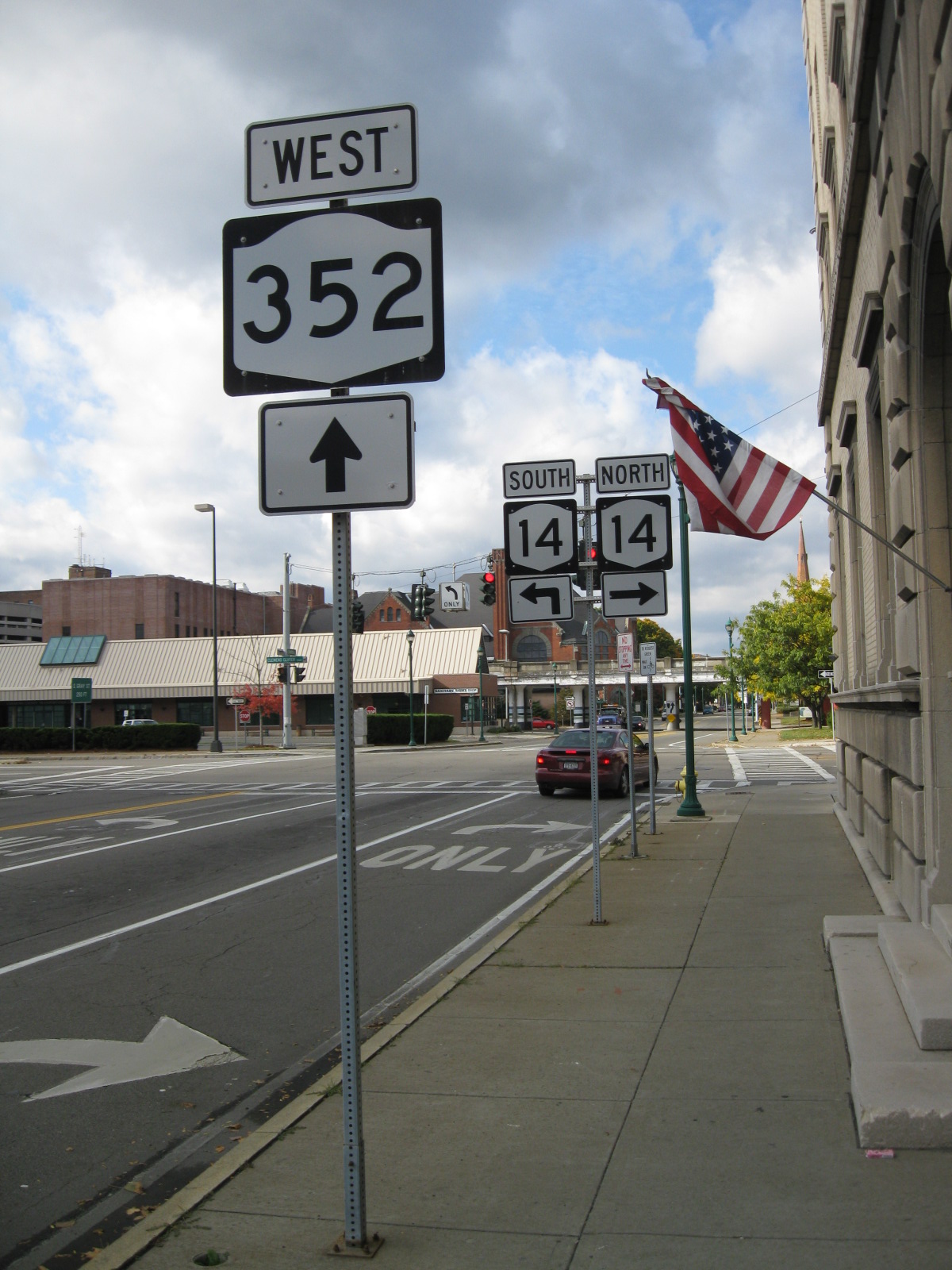
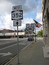 NY 352 heading westbound towards the intersection with NY 14 in Elmira
NY 352 begins at an intersection with NY 415 in the village of Riverside. It heads south along Buffalo Street to Denison Parkway, where it connects to the Southern Tier Expressway (Interstate 86 and NY 17) by way of exit 45. Here, NY 352 turns eastward and follows Denison Parkway into the city of Corning. It heads southeast through downtown, intersecting the southern terminus of NY 414 at Cedar Street and the northern terminus of NY 225 at Conhocton Street. East of NY 225, the route crosses over the Chemung River to serve the hamlet of Gibson.
NY 352 runs parallel to the Chemung River and the Southern Tier Expressway to the hamlet of Big Flats. Here, NY 352 turns southward to follow the Chemung River southeastward through the town of Big Flats. Along this stretch, NY 352 intersects a back road to the National Soaring Museum on Harris Hill and serves the Elmira Drive In, one of the few remaining drive-in theaters still in operation in the region.
Just northwest of the Big Flats – Elmira town line, NY 352 reconnects to NY 225 in an area known as Golden Glow Heights. NY 352 continues into the community of West Elmira, where it splits into a one-way couplet at Coleman and York Avenues. Eastbound NY 352 is routed on Water Street while the westbound direction follows Church Street. Now in the city of Elmira, the two one-way streets become bi-directional at Hoffman Street; however, NY 352 remains split. In downtown Elmira, the route intersects NY 14 (the Clemens Center Parkway). NY 352 continues east to the eastern fringe of the city and the Southern Tier Expressway, where it ends at exit 56, a combined double diamond interchange that handles both Water and Church Streets. Past the interchange, Water Street becomes County Route 1 (Jerusalem Hill Road).
History
In the 1930 renumbering of state highways in New York, a spur of NY 17 between the hamlet of Big Flats and NY 13 in the town of Elmira was designated as NY 17E. At the time, NY 17 was routed on Main Street and Big Flats Road in the vicinity of Big Flats.[4] NY 17E was extended eastward into Elmira in the early 1940s after NY 13 was truncated to a new southern terminus in downtown Elmira.[5][6] At the time, both NY 13 and NY 17E ended at the junction of Church Street and Madison Avenue, the latter then part of NY 17.[7] NY 17E was extended slightly by 1953 to continue east along Church Street to Sullivan Street and southward on Sullivan Street to Water Street (NY 17).[8]
A bypass for NY 17 in the Elmira area was built in the 1950s. The first section from Horseheads south to the eastern fringe of downtown Elmira was completed in the mid-1950s, resulting in a short eastern extension of NY 17E to the east side of Newtown Creek (exit 56).[9][10] The second half of the bypass, from East Corning eastward to Horseheads, was open by 1958, and NY 17's original alignment from East Corning (exit 48) to Big Flats became a western extension of NY 17E.[11] In the mid-1960s, NY 17E was renumbered to NY 352.[1][2]
In the mid-1980s, the NY 17 bypass was extended west to NY 414 (exit 46) in Corning.[12] NY 17 initially exited the expressway south of Gibson at exit 47 to rejoin its original surface alignment into Corning. Although the former routing of NY 17 between exits 47 and 48 lacked a designation, NY 352 was not immediately extended westward from exit 45.[13] The Corning Bypass on NY 17 was completed in the mid-1990s,[12] at which time NY 352 was extended west on the old surface NY 17 across the Gibson Bridge, through downtown Corning and across the Patterson Bridge to exit 45.[14]
Downtown Elmira
NY 352 was reconfigured in Elmira by 1969 to split into two one-way streets in West Elmira. Westbound NY 352 followed Church Street through Elmira while eastbound NY 352 followed Water Street. Eastbound NY 352 left Water Street at Sullivan Street and followed Sullivan Street for three blocks north to Church Street. Here, NY 352 came back together and continued east along Church Street to NY 17 as a two-way street.[15] By 1978, the portion of Sullivan Street between Water Street and John Street was removed. As a result, NY 352 now left Water Street at Madison Avenue and followed Madison north to Church Street.[16] NY 352 eastbound was changed again by 1995 to follow Water Street east to NY 17.[17]
In 2005, the portions of Church and Water Streets east of Hoffman Street were reconfigured to carry two-way traffic.[citation needed] However, NY 352 remains split along the two streets for historical reasons.[citation needed]
Major intersections
County Location Mile[3] Destinations Notes Steuben Riverside 0.00 NY 415 (High Street) I-86 / NY 17 (Southern Tier Expressway) via Denison ParkwayExit 45 (I-86 / NY 17) City of Corning NY 414 (Cedar Street)Southern terminus of NY 414 2.40  NY 225 (Park Avenue)
Northern terminus of NY 225 Town of Corning 3.91 I-86 / NY 17 (Southern Tier Expressway)Exit 47 (I-86 / NY 17) 6.20 I-86 / NY 17 (Southern Tier Expressway)Hamlet of East Corning; exit 48 (I-86 / NY 17) Chemung Town of Big Flats 14.35 NY 225 (Hendy Creek Road)Southern terminus of NY 225 City of Elmira 17.66 NY 14 (Clemens Center Parkway)18.96 I-86 / NY 17 (Southern Tier Expressway)Exit 56 (I-86 / NY 17); current eastern terminus of I-86's western segment 1.000 mi = 1.609 km; 1.000 km = 0.621 mi See also
- New York State Route 417, the next piece of old NY 17 to the west
- New York State Route 17C, the next numbered piece of old NY 17 to the east
References
- ^ a b Sinclair (1964). New York and Metropolitan New York (Map). Cartography by Rand McNally and Company.
- ^ a b Esso (1968). New York (Map). Cartography by General Drafting (1969–70 ed.).
- ^ a b "2008 Traffic Volume Report for New York State" (PDF). New York State Department of Transportation. June 16, 2009. pp. 217–218. https://www.nysdot.gov/divisions/engineering/technical-services/hds-respository/NYSDOT%20TVR%202008%20by%20Route.pdf. Retrieved February 1, 2010.
- ^ Pennsylvania Department of Highways (1930) (PDF). Tourist Map of Pennsylvania (Map). ftp://ftp.dot.state.pa.us/public/pdf/BPR_pdf_files/Maps/Statewide/Historic_OTMs/1930fr.pdf. Retrieved July 7, 2009.
- ^ Esso (1940). New York (Map). Cartography by General Drafting.
- ^ Esso (1942). New York with Pictorial Guide (Map). Cartography by General Drafting.
- ^ State of New York Department of Public Works. Official Highway Map of New York State (Map). Cartography by General Drafting (1947–48 ed.).
- ^ United States Geological Survey (1953). Elmira Quadrangle – New York – Pennsylvania (Map). 1:62,500. 15 Minute Series (Topographic). http://historical.mytopo.com/getImage.asp?state=NY&fname=elmi53se.jpg. Retrieved July 7, 2009.
- ^ Esso (1954). New York with Special Maps of Putnam–Rockland–Westchester Counties and Finger Lakes Region (Map). Cartography by General Drafting (1955–56 ed.).
- ^ Esso (1956). New York with Special Maps of Putnam–Rockland–Westchester Counties and Finger Lakes Region (Map). Cartography by General Drafting (1957 ed.).
- ^ Esso (1958). New York with Special Maps of Putnam–Rockland–Westchester Counties and Finger Lakes Region (Map). Cartography by General Drafting (1958 ed.).
- ^ a b National Bridge Inventory, a database compiled by the United States Department of Transportation Federal Highway Administration, available at www.nationalbridges.com. Accessed July 7, 2009.
- ^ Pennsylvania Department of Transportation (1989) (PDF). Pennsylvania Official Transportation Map (Map). ftp://ftp.dot.state.pa.us/public/pdf/BPR_pdf_files/Maps/Statewide/Historic_OTMs/1989fr.pdf. Retrieved July 7, 2009.
- ^ Sinsabaugh, Mark. "New York State Route 352". New York Routes. http://www.gribblenation.net/nyroutes/ind/350_359.htm#352. Retrieved July 7, 2009.
- ^ United States Geological Survey (1959). Elmira Quadrangle – New York – Pennsylvania Co. (Map). 1:24,000. 7.5 Minute Series (Topographic). http://www.nysgis.state.ny.us/gisdata/quads/drg24/usgspreview/index.cfm?code=o42076a7. Retrieved July 7, 2009.
- ^ New York State Department of Transportation (1978). Elmira Digital Raster Quadrangle (Map). 1:24,000. http://www.nysgis.state.ny.us/gisdata/quads/drg24/dotpreview/index.cfm?code=x24. Retrieved July 7, 2009.
- ^ Rand McNally and Company (1995). New York (Map). ISBN 0-528-96764-9.
External links
Categories:- State highways in New York
- Interstate 86 (east)
- Transportation in Chemung County, New York
- Transportation in Steuben County, New York

Wikimedia Foundation. 2010.