- New York State Route 427
-
This article is about the current alignment of NY 427. For the former alignment of NY 427 in Essex County, see New York State Route 427 (1931–1938).
NYS Route 427
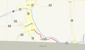
Map of the Elmira area with NY 427 highlighted in redRoute information Maintained by NYSDOT Length: 11.49 mi[3] (18.49 km) Existed: early 1940s[1][2] – present Major junctions West end:  NY 14 in Southport
East end:  NY 17 in Chemung
Location Counties: Chemung Highway system Numbered highways in New York
Interstate • U.S. • N.Y. (former) • Reference • County←  NY 426
NY 428  →
→←  NY 17C
NY 17E  →
→←  NY 378
NY 380  →
→New York State Route 427 (NY 427) is an east–west state highway in Chemung County, New York, United States. It extends for 11.5 miles (18.5 km) from its western terminus at an intersection with NY 14 in the town of Southport, south of the city of Elmira, to its eastern terminus at an interchange with NY 17 in the town of Chemung. Between those two towns, the highway passes through the town of Ashland and serves the village of Wellsburg. Much of NY 427 follows the Chemung River.
The route was assigned in the early 1940s, replacing New York State Route 17D, a route established as part of the 1930 renumbering of state highways in New York. It originally began in downtown Elmira and ended at the Pennsylvania state line in Chemung. NY 427 was realigned on its east end in 1967 to meet the newly-constructed exit 59 on NY 17 and on its west end in 1978 to follow what had been New York State Route 379 through the town of Southport. Other minor realignments have occurred over the years as well.
Contents
Route description
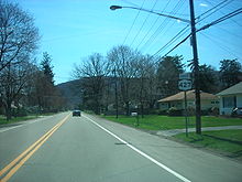 Eastbound on NY 427 just south of Cedar Street in Southport
NY 427 begins at an intersection with NY 14 (the Clemens Center Parkway) in Southport, a town located south of the city of Elmira.[3] It heads east, following Cedar Street and paralleling Seeley Creek through the southern suburbs of Elmira to an intersection with Maple Avenue near Notre Dame High School. Here, NY 427 turns south to follow Maple Avenue into the adjacent town of Ashland and across Seeley Creek.[4]
As the route heads through Ashland, it generally turns to the southeast to match the curvature of the Chemung River valley, which contains the river, NY 427, and the Southern Tier Expressway (NY 17). NY 427 parallels both the river and the expressway into Wellsburg, a small village sandwiched between the Chemung River and the Pennsylvania state line. In the center of the village, NY 427, named Front Street, intersects with the northern end of NY 367, a short highway linking NY 427 to the Pennsylvania border. Just east of NY 367, NY 427 intersects County Route 8 (CR 8), a highway that crosses the Chemung River and links Wellsburg to NY 17 at exit 58.[4]
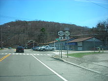 Eastbound on NY 427 at NY 367 in Wellsburg
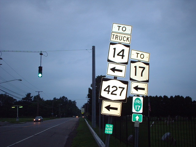
Outside of Wellsburg, NY 427 becomes Wilawana Road and heads eastward, paralleling both the Chemung River and the Norfolk Southern Railway-owned Southern Tier Line through the town of Chemung toward the Pennsylvania state line. Less than 300 yards (270 m) from the Pennsylvania border, NY 427 departs Wilawana Road and turns northeast onto Wyncoop Creek Road. NY 427 crosses the Chemung River before coming to an end at an interchange with NY 17 0.5 miles (0.8 km) later.[4] Although NY 427 comes to an end at this interchange, the road continues onward through the interchange as NY 961A, an unsigned reference route.[3]
History
Origins and designation
Most of what is now NY 427 was originally designated as NY 17D in the 1930 renumbering. NY 17D began at the intersection of East Water Street (NY 17) and Madison Avenue (NY 14 and NY 17) in downtown Elmira. NY 17D headed west, overlapping NY 14 along Water Street to Lake Street, where NY 17D turned south and followed Lake Street and Pennsylvania Avenue over the Chemung River to Maple Avenue. Here, NY 17D turned to the southeast to follow Maple Avenue through southern Elmira. At Cedar Street, NY 17D joined the modern alignment of NY 427. From this point east, NY 17D followed what is now NY 427 to Wyncoop Creek Road in Chemung, where it continued on Wilawana Road to the Pennsylvania border.[5]
In the months immediately following the 1930 renumbering, NY 14 was routed on Pennsylvania Avenue and South Main Street through southern Elmira.[6] By 1935, NY 14 was rerouted to follow Pennsylvania Avenue into downtown. As a result, all of NY 17D north of the junction of Pennsylvania and Maple Avenues became concurrent with NY 14.[7][8] The overlap was eliminated in the early 1940s when NY 17D was pulled back to the intersection of Pennsylvania and Maple Avenues and renumbered as NY 427.[1][2]
Realignments
 Signage at the intersection of Cedar Street and Maple Avenue in Southport in 2004. Until 1978, NY 427 continued straight and NY 379 began to the left
The routing of NY 427 in the vicinity of Elmira has varied over time. Ca. 1961, NY 14 was realigned to follow South Main Street once again. NY 427 was then extended northward along Pennsylvania Avenue to a new terminus at Water Street (NY 14 and NY 17E; later NY 352) in downtown Elmira.[9][10] This alignment remained in place until October 23, 1978, when NY 427 was rerouted to bypass Elmira entirely. Instead of continuing north into downtown, NY 427 turned west at Cedar Street and followed it through Southport to a new terminus at Pennsylvania Avenue (NY 14). The realignment of NY 427 through Southport supplanted NY 379,[11][12][13] which had been assigned to the portion of Cedar Street between Pennsylvania and Maple Avenues since ca. 1931.[6][14] The west end of NY 427 was shifted 0.25 miles (0.40 km) east to its present location in late 2001 following the completion of the Clemens Center Parkway, a four-lane arterial carrying NY 14 through the center of Elmira.[15]
Like the western terminus of NY 427, the eastern terminus of the route has changed over the years. In 1967, NY 17 exit 59 in Chemung opened to traffic.[16] NY 427 was subsequently rerouted along Wyncoop Creek Road to meet the Southern Tier Expressway at the new interchange.[17]
The former routing of NY 427 along Wilawana Road between Wyncoop Creek Road and the Pennsylvania state line was designated as NY 961B while the portion of former NY 427 along Maple Avenue from Cedar Street north to the Elmira city line was designated as NY 961K, both unsigned reference route designations.[18] NY 961B still exists today;[11] however, NY 961K ceased to exist at some point between 2004 and 2006.[18][19] The portion of Maple Avenue between NY 427 and the Elmira city limits is now maintained by Chemung County and designated as CR 85,[3][20] although it is still listed as a state highway in the New York State Highway Law.[21] The portion of Cedar Street between Pennsylvania Avenue and NY 14 is now CR 84.[20]
Major intersections
The entire route is in Chemung County.
Location Mile[3] Destinations Notes Southport 0.00 NY 141.17  CR 85 (Maple Avenue)
Former routing of NY 427 Wellsburg 5.49  NY 367
Northern terminus of NY 367 Chemung 11.49 NY 17Exit 59 (NY 17) 1.000 mi = 1.609 km; 1.000 km = 0.621 mi References
- ^ a b Gulf Oil Company (1940). New York Info-Map (Map). Cartography by Rand McNally and Company.
- ^ a b Esso (1942). New York with Pictorial Guide (Map). Cartography by General Drafting.
- ^ a b c d e "2008 Traffic Data Report for New York State" (PDF). New York State Department of Transportation. June 16, 2009. p. 313. https://www.nysdot.gov/divisions/engineering/technical-services/hds-respository/NYSDOT_Traffic_Data_Report_2008.pdf. Retrieved November 14, 2009.
- ^ a b c Yahoo! Inc. Yahoo! Maps – overview map of NY 427 (Map). Cartography by NAVTEQ. http://maps.yahoo.com/#mvt=m&lat=42.031445&lon=-76.716975&zoom=14&q1=42.05822%2C-76.80626&q2=42.007761%2C-76.627721. Retrieved November 14, 2009.
- ^ Automobile Legal Association (ALA) Automobile Green Book, 1930/31 and 1931/32 editions, (Scarborough Motor Guide Co., Boston, 1930 and 1931). The 1930/31 edition shows New York state routes prior to the 1930 renumbering
- ^ a b Pennsylvania Department of Highways (1930) (PDF). Tourist Map of Pennsylvania (Map). ftp://ftp.dot.state.pa.us/public/pdf/BPR_pdf_files/Maps/Statewide/Historic_OTMs/1930fr.pdf. Retrieved November 14, 2009.
- ^ Sun Oil Company (1935). Road Map & Historical Guide – New York (Map). Cartography by Rand McNally and Company.
- ^ Thibodeau, William A. (1938). The ALA Green Book (1938–39 ed.). Automobile Legal Association.
- ^ Gulf (1960). New York and New Jersey Tourgide Map (Map). Cartography by Rand McNally and Company.
- ^ Sunoco (1961). New York and Metropolitan New York (Map). Cartography by H.M. Gousha Company (1961–62 ed.).
- ^ a b New York State Department of Transportation (January 2009) (PDF). Official Description of Highway Touring Routes, Bicycling Touring Routes, Scenic Byways, & Commemorative/Memorial Designations in New York State. https://www.nysdot.gov/divisions/operating/oom/transportation-systems/repository/2009%20tour-bk.pdf. Retrieved November 14, 2009.
- ^ Exxon (1977). New York (Map). Cartography by General Drafting (1977–78 ed.).
- ^ State of New York (1981). I Love New York Tourism Map (Map). Cartography by Rand McNally and Company.
- ^ Kendall Refining Company (1931). New York (Map). Cartography by H.M. Gousha Company.
- ^ Sinsabaugh, Mark. "New York State Route 14". New York Routes. http://www.gribblenation.net/nyroutes/ind/010_019.htm#014. Retrieved November 14, 2009.
- ^ Federal Highway Administration (2008). "Structure 1061310". National Bridge Inventory. United States Department of Transportation. http://nationalbridges.com/nbi_record.php?StateCode=36&struct=000000001061310. Retrieved January 3, 2010.
- ^ State of New York Department of Transportation (January 1, 1970) (PDF). Official Description of Touring Routes in New York State. http://www.greaternyroads.info/pdfs/state70.pdf. Retrieved November 14, 2009.
- ^ a b New York State Department of Transportation (October 2004) (PDF). Official Description of Highway Touring Routes, Scenic Byways, & Bicycle Routes in New York State. https://www.nysdot.gov/divisions/operating/oom/transportation-systems/repository/tour_route_0.pdf. Retrieved November 14, 2009.
- ^ "2005 Traffic Data Report for New York State" (PDF). New York State Department of Transportation. August 16, 2006. p. 331. https://www.nysdot.gov/divisions/engineering/technical-services/hds-respository/NYSDOT_Traffic_Data_Report_2005.pdf. Retrieved November 14, 2009.
- ^ a b New York State Department of Transportation (March 2, 2009). "Region 6 Inventory Listing". https://www.nysdot.gov/divisions/engineering/technical-services/highway-data-services/inventory-listing. Retrieved November 14, 2009.
- ^ New York State Legislature. "New York State Highway Law § 341". http://public.leginfo.state.ny.us/menugetf.cgi?COMMONQUERY=LAWS. Retrieved November 14, 2009.
External links
Categories:- State highways in New York
- Transportation in Chemung County, New York


Wikimedia Foundation. 2010.