- New York State Route 17C
-
NYS Route 17C
Route information Auxiliary route of NY 17 Maintained by NYSDOT and the city of Binghamton Length: 40.34 mi[3] (64.92 km) Existed: 1930[1][2] – present Major junctions West end:  NY 34 in Waverly
 NY 96 in Owego
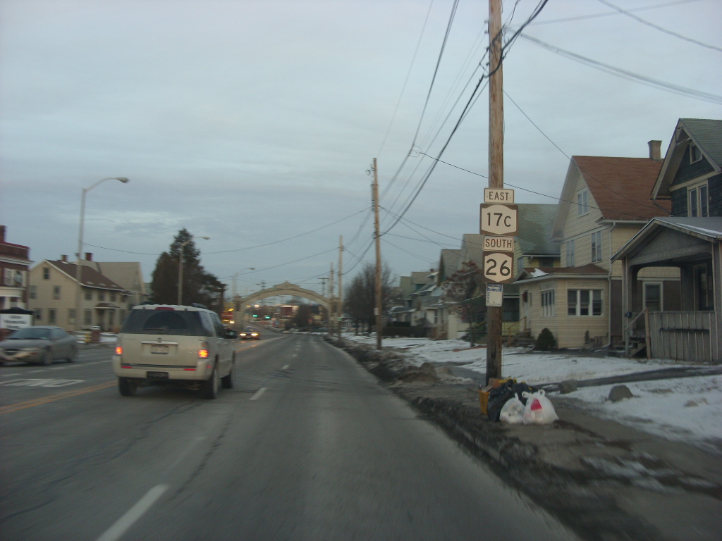
 NY 26 in Endicott
 NY 201 in Johnson City
East end:  US 11 in Binghamton
Location Counties: Tioga, Broome Highway system Numbered highways in New York
Interstate • U.S. • N.Y. (former) • Reference • County←  NY 17B
NY 17D  →
→New York State Route 17C (NY 17C) is a state highway in the Southern Tier of New York. Its western terminus is at an intersection with NY 34 in Waverly, Tioga County while its eastern terminus is at an intersection with U.S. Route 11 in Binghamton, Broome County. The route runs concurrently with NY 96 for a block in Owego and for a few blocks with NY 26 in Endicott.
The stretch between Waverly and Owego is the former NY 17, as it was routed prior to the opening of the Southern Tier Expressway. The stretch from NY 96 to Binghamton is the original routing of NY 17C and serves as an alternate route between Owego and the Triple Cities.
Contents
Route description
Tioga County
NY 17C officially runs east from the intersection with Route 34 at Chemung Street and Cayuta Avenue in the east side of Waverly, but there are street signs along Chemung Street that say "Route 17C" as far west as the Shepherd Hills Golf Course, near the Chemung County line. There is little, if any, evidence that New York state ever signed the highway that far west.
From Waverly, the route passes through the Ellistown area and runs parallel to and north of the Southern Tier Expressway. In fact, this part of the highway was Route 17 prior to the opening of the expressway in the 1970s.

Where the expressway crosses the Susquehanna River just south of the Cannon Hole area, NY 17C stays on the north side of the river, bypassing the Cannon Hole neighborhood and the hamlet of Barton within the town of the same name. NY 282 runs south from NY 17C about midway between the Tioga hamlets of Smithboro and Tioga Center. In Tioga Center, NY 17C is the southern terminus of Halsey Valley Road (County Road 7), which was New York's first NY 225.
The highway becomes Main Street in Owego, entering the village near the fairgrounds. At the village's main square, NY 17C meets NY 96. The two routes form a concurrency for a short distance along the one-way sections of Court Street (westbound) and Park Street (eastbound) around the Tioga County Courthouse before splitting at Front Street. NY 96 continues across the Susquehanna River to access NY 17 and NY 434 while NY 17C continues east on Front Street through an old residential area. This was where the original Route 17C started, as pre-expressway Route 17 followed Route 96 to a routing (now NY 434) across the river.
In the eastern part of the village, NY 17C breaks from Front Street and continues straight onto Fifth Avenue, following the north bank of the river as it progresses. The highway between the Front Street/Fifth Avenue intersection and the NY 17 access road near Hickories Park is well-developed with retail establishments.
For the next several miles, the highway runs alongside the Norfolk Southern Railway tracks, which separate it from the north bank of the river. Near Campville, the highway serves as the northern terminus of NY 962J, a short reference route traversing the Susquehanna River. Although most reference routes are unsigned, NY 962J is one of four within the state that is erroneously signed as a touring route. The route, a connector between Campville and Apalachin over the Susquehanna that opened in 2001, is known locally as the "Millennium Bridge".
Broome County
After passing through Campville, the highway crosses into Broome County, then enters Endicott as West Main Street, near the En-Joie Golf Course, former site of the PGA's annual B.C. Open until 2005. This section has been rebuilt within the last few years. Further along its path, 17C runs concurrently with NY 26 for approximately one mile in the village between Nanticoke/Exchange Avenues and McKinley Avenue before Route 26 continues to the south. West Main Street becomes East Main Street east of Nanticoke Avenue.
Between Endicott and Johnson City, NY 17C is split into one-way sections, with each serving as a frontage road for the expressway. While in this configuration, NY 17C is known as the George F. Highway.

The divided sections of the highway rejoin each other as Main Street west of Johnson City in the hamlet of Westover. This portion of NY 17C is urban and heavily commercial in character as it forms the primary west–east route through Johnson City and Binghamton. There are arches over the highway at either end of Johnson City commemorating the village's role as home to the former Endicott-Johnson Shoe Corporation.
NY 17C ends at U.S. Route 11 in Binghamton, just west of the Chenango River. Main Street, however, continues east for an additional 80 yards (73 m) to the Court Street Bridge as part of US 11.
History
The section of what is now NY 17C between Waverly and Owego was originally designated as part of Route 4, an unsigned legislative route, by the New York State Legislature in 1908.[4][5] When the first set of posted routes in New York were assigned in 1924, most of legislative Route 4—including from Waverly to Owego—became part of NY 17.[6][7] In the 1930 renumbering of state highways in New York, NY 17 was left as-is from Waverly to Owego while NY 17C was assigned to the portion of its current alignment east of Owego.[1][2]
On January 1, 1970, NY 17 was officially rerouted onto the new Southern Tier Expressway (STE) between Waverly and Vestal[8] even though the section of the freeway between Waverly and Nichols had yet to be completed. In actuality, NY 17 continued to follow its original surface alignment from Waverly to Nichols, where it used a portion of NY 282 to reach the freeway. The former surface routing of NY 17 from Nichols to Owego became part of an extended NY 17C ca. 1971.[8][9] The Waverly–Nichols segment of the STE was completed ca. 1974, at which time NY 17 was realigned to follow the freeway[10][11] while NY 17C was extended west over NY 17's former alignment to Waverly.[12]
Major intersections
County Location Mile[3] Destinations Notes Tioga Waverly 0.00 NY 34Tioga 9.93  NY 282
Northern terminus of NY 282 15.30 Halsey Valley Road (CR 7) Hamlet of Tioga Center; former southern terminus of NY 225 Village of Owego 18.74 NY 96 northNorthern terminus of NY 17C / NY 96 overlap 18.87 NY 96 southSouthern terminus of NY 17C / NY 96 overlap Town of Owego 27.14  NY 962J
Hamlet of Campville; northern terminus of NY 962J Broome Endicott 31.97 NY 26 northWestern terminus of NY 17C / NY 26 overlap 33.21 NY 26 southEastern terminus of NY 17C / NY 26 overlap Union 35.24  NY 17
NY 17Exit 69 (NY 17); a divided NY 17C serves as the frontage/service road for both directions of NY 17 Binghamton 37.43 NY 201Partial cloverleaf interchange 40.34 US 111.000 mi = 1.609 km; 1.000 km = 0.621 mi References
- ^ a b Standard Oil Company of New York (1929). New York in Soconyland (Map). Cartography by General Drafting.
- ^ a b Standard Oil Company of New York (1930). Road Map of New York (Map). Cartography by General Drafting.
- ^ a b "2008 Traffic Volume Report for New York State" (PDF). New York State Department of Transportation. June 16, 2009. pp. 55–56. https://www.nysdot.gov/divisions/engineering/technical-services/hds-respository/NYSDOT%20TVR%202008%20by%20Route.pdf. Retrieved January 31, 2010.
- ^ State of New York Department of Highways (1909). The Highway Law. Albany, New York: J. B. Lyon Company. pp. 54–55. http://books.google.com/books?id=jZ0AAAAAMAAJ&pg=PA54. Retrieved July 19, 2010.
- ^ New York State Department of Highways (1920). Report of the State Commissioner of Highways. Albany, New York: J. B. Lyon Company. pp. 502–505. http://books.google.com/books?id=Sj4CAAAAYAAJ&pg=PA502. Retrieved July 19, 2010.
- ^ "New York's Main Highways Designated by Numbers". The New York Times: p. XX9. December 21, 1924.
- ^ State of New York Department of Public Works (1926). Official Map Showing State Highways and other important roads (Map). Cartography by Rand McNally and Company.
- ^ a b State of New York Department of Transportation (January 1, 1970) (PDF). Official Description of Touring Routes in New York State. http://www.greaternyroads.info/pdfs/state70.pdf. Retrieved July 19, 2010.
- ^ New York State Thruway Authority (1971). New York Thruway (Map). Cartography by Rand McNally and Company.
- ^ Shell Oil Company (1973). New York (Map). Cartography by H.M. Gousha Company (1973 ed.).
- ^ Gulf Oil Company (1974). New York and New Jersey Tourgide Map (Map). Cartography by Rand McNally and Company.
- ^ Exxon (1977). New York (Map). Cartography by General Drafting (1977–78 ed.).
External links
Categories:- State highways in New York
- Interstate 86 (east)
- Transportation in Broome County, New York
- Transportation in Tioga County, New York

Wikimedia Foundation. 2010.