- New York State Route 34
-
This article is about the current alignment of NY 34. For the former alignment of NY 34 in Erie and Niagara County, see New York State Route 34 (1924–1930).
NYS Route 34
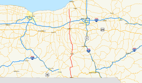
Map of central New York with NY 34 highlighted in redRoute information Maintained by NYSDOT and the cities of Ithaca and Auburn Length: 99.33 mi[3] (159.86 km) Existed: 1930[1][2] – present Major junctions South end: 
 NY 17 / PA 199 at Waverly
 NY 96 in Spencer

 NY 79 / NY 89 / NY 96 in Ithaca
 NY 90 in Genoa


 US 20 / NY 5 / NY 38 in Auburn

 I-90 / Thruway near Weedsport
North end:  NY 104 in Hannibal
Location Counties: Tioga, Chemung, Tompkins, Cayuga, Oswego Highway system Numbered highways in New York
Interstate • U.S. • N.Y. (former) • Reference • County←  NY 33A
NY 34B  →
→New York State Route 34 (NY 34) is a north–south New York state route located in Central New York. Its southern terminus is at the Pennsylvania state line in the village of Waverly, where it connects to Pennsylvania Route 199 and meets NY 17. Its northern terminus is at NY 104, outside the village of Hannibal.
Contents
Route description
Tioga and Chemung Counties
The highway begins at exit 61 of the Southern Tier Expressway, NY 17, where PA 199 crosses into New York state, and Tioga County, on Cayuta Avenue in Waverly. Little more than half a mile into the state, Cayuta Street (NY 34) comes to a T-intersection with NY 17C. Route 34 makes a sharp left and, shortly thereafter, a sharp right turn. NY 17C was formerly NY 17, and the afore-mentioned second sharp turn was once Route 34's southern terminus. NY 34 continues north along the east bank of Cayuta Creek across the county line to Van Etten, Chemung County.
In that village, NY 34 turns east at the eastern terminus of NY 224. Less than a mile from NY 224, NY 34 exits Chemung County and reenters Tioga County. NY 34 continues east to Spencer, where it meets up with NY 96. The routes converge from each end of Tioga Street and continue north together on Main Street. After exiting the village, NY 34 and NY 96 continue northward through the county, entering Tompkins County five miles (8 km) from Spencer.
Tompkins County
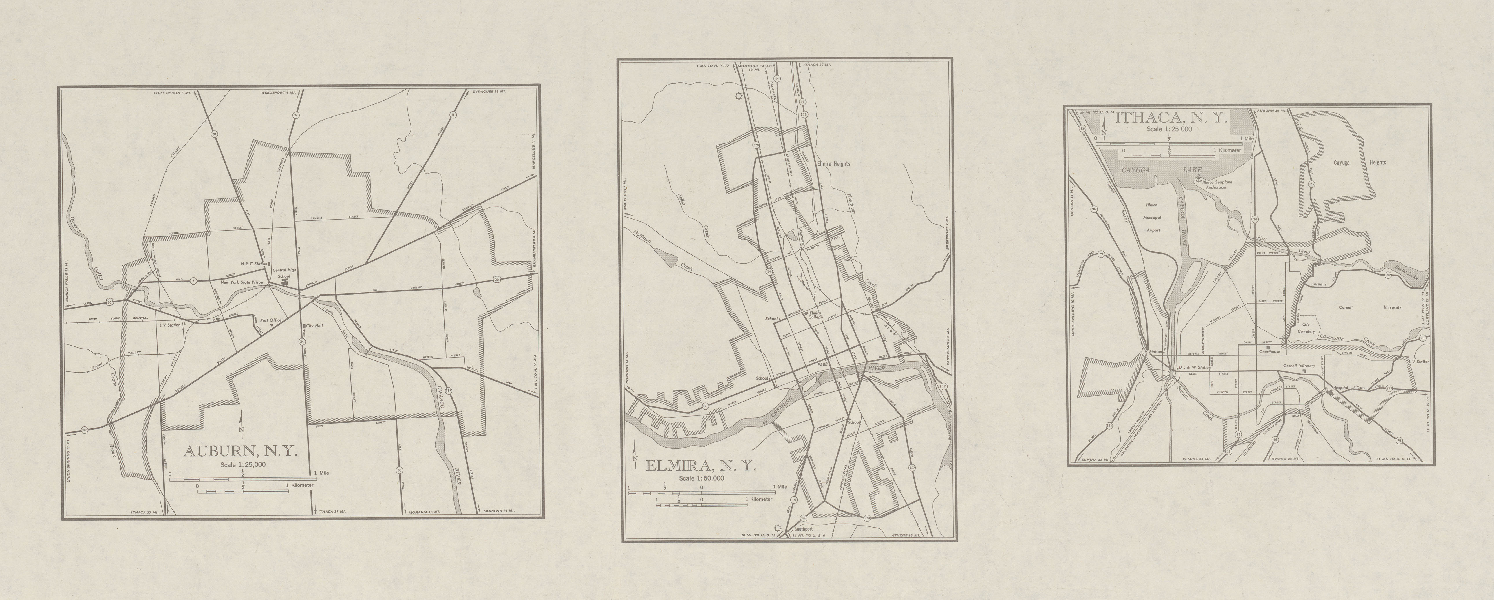
A few miles south of Ithaca, NY 34 and NY 96 merge with Elmira Road near Treman State Park, joining NY 13 northward through Buttermilk Falls State Park to Ithaca. Formerly, Meadow Street carried both directions of NY 13 and NY 34 (and NY 96) through a large part of Ithaca; however, in the late 1990s southbound traffic was diverted to Fulton Street for a ten-block section. NY 96 diverges to the west at West Buffalo Street in this section. NY 34 diverges from the NY 13 freeway in the northern part of the city. In Ithaca, NY 34 passes the Ithaca Farmers Market, the Sciencenter, and Stewart Park.
Between NY 13 and Cayuga Heights Road in the Village of Lansing, NY 34 ascends a hill, offering a view down Cayuga Lake. The highway is close to the lake shore itself for an approximately two mile stretch prior to the hill. Descending the hill, one is offered a view of the city. Easily seen is the West and East Dormitory Towers of Ithaca College, located on NY 96B.
In the town of Lansing, the highway intersects with NY 34B, a loop that serves the small communities along the ridge to the west of NY 34. Six miles due north of the NY 34/NY 34B intersection, NY 34 passes into Cayuga County.
Cayuga and Oswego Counties
Like NY 34B to the west, NY 34 serves a handful of small communities in southern and central Cayuga county, including Genoa, at the intersection with NY 90. Five miles south of Auburn in Fleming, NY 34B rejoins NY 34, terminating at a T-intersection.
In downtown Auburn, NY 34 is co-signed with NY 38 from the southern edge of the city north to NY 5 and U.S. Route 20, where NY 38 turns west. Within downtown Auburn, NY 34 passes by the Harriet Tubman Home and the William Seward House.
From Auburn, NY 34 continues north to Weedsport, where the route meets the New York State Thruway (Interstate 90) at exit 40. Farther north, NY 34 enters Cato and meets NY 370 in the village center. Six miles to the north, NY 34 changes counties for the final time, entering Oswego County.
Of the 100 miles (161 km) of NY 34, only four miles of the route exists in Oswego County. NY 34 intersects only six roads in the county, the most notable of which is NY 104, located south of Hannibal.
History
Origins
In 1908, the New York State Legislature created a statewide system of unsigned legislative routes. The portion of what is now NY 34 from Van Etten to Ithaca was included in Route 9, which originally began in Horseheads and went generally northeast across central New York to Bouckville. North of Ithaca, two sections of modern NY 34—from Cayuga Heights Road north to current NY 34B in Lansing and from the north end of NY 34B in Fleming to Auburn—became part of Route 11.[4][5] On March 1, 1921, Route 9 was realigned south of Van Etten to follow modern NY 34 south to Chemung Street in Waverly.[6] When the first set of posted routes in New York were assigned in 1924, none of modern NY 34 received a signed designation except for the current overlap between NY 34 and NY 13 south of Ithaca, which became NY 13 at this time.[7][8]
By 1926, what is now NY 34 from Ithaca north to Cato was designated as part of NY 40, which continued northwest to Red Creek mostly by way of modern NY 370. South of Ithaca, current NY 34 was part of NY 53 from Van Etten to Spencer.[8] Within Ithaca, NY 13 was routed on Spencer Road and Cayuga Street to Court Street, where NY 13 turned east and followed Court Street and University Avenue out of the city. NY 40, meanwhile, began at NY 15 (now NY 96) at the intersection of State and Aurora Streets, one block east of NY 13. NY 40 followed Aurora, Falls, and Lake Streets through the city before joining the current alignment of NY 34 at the southeastern edge of Cayuga Lake.[9]
Designation and extensions
In the 1930 renumbering of state highways in New York, NY 40 was reassigned to another highway in the Capital District. Its former alignment became part of two new routes, namely NY 370 west of Cato and NY 34 south of Cato.[10] Unlike NY 40 before it, NY 34 continued south to Chemung Street (then NY 17) in Waverly, utilizing the post-1921 alignment of legislative Route 9 between Ithaca and Waverly.[1][2] NY 34 was extended south to the Pennsylvania state line in the early 1970s following the completion of the Southern Tier Expressway through Waverly.[11][12]
NY 34 was extended north from Cato to the super two highway carrying NY 104 around Hannibal in the early 1970s. Initially, NY 34 veered east on Ira Hill East and North Roads and on Oswego County Route 21 to serve Hannibal Center;[11][13] however, it was moved onto its current alignment between Cato and Hannibal by 1977.[14] The portion of NY 34 north of Cato was county-maintained until the early 1980s when the state of New York acquired ownership of the highway as part of two highway maintenance swaps with Oswego and Cayuga Counties. The section of NY 34 between the Cayuga County line and NY 104 became state-maintained on April 1, 1980, while the segment between NY 370 and the Oswego County line was turned over to the state on April 1, 1981.[15] The county-maintained continuation of NY 34 to NY 3 in Hannibal is designated and signed as County Route 34.[16]
Ithaca area
NY 34 has been realigned through Ithaca at least three times since the 1930s. By 1948, NY 34 was shifted westward to follow Albany, Court, and Cayuga Streets through downtown.[17] In the early 1960s, a new expressway was built along the eastern shore of Cayuga Lake, bypassing downtown Ithaca on the west and north.[18][19] NY 34 was altered to follow Meadow Street and the freeway between southwestern Ithaca and its original alignment on East Shore Drive north of the city.[20] The portion of NY 34's former alignment on East Shore Drive north of the Ithaca city line became NY 930F, an unsigned reference route.[21] Lastly, in 1996, ten blocks of southbound NY 34 was diverted from Meadow Street to Fulton Street as part of the Octopus elimination project.[22]
Suffixed routes
NY 34 has had two suffixed routes; one has since been removed.
- NY 34A was an alternate route of NY 34 between Ithaca and Lansing. It split from NY 34 at the intersection of Court and Cayuga Streets, where NY 34 turned north to follow Cayuga through downtown. NY 34A was routed along Court Street, Linn Street, University Avenue, and Cayuga Heights Road through Ithaca to Lansing, where it rejoined its parent north of the city.[17] The route was assigned ca. 1932[23][24] and eliminated in the mid-1960s.[20][25]
- NY 34B (34.03 miles or 54.77 kilometres) is an alternate route of NY 34 from NY 38 south of Groton, Tompkins County to NY 34 south of Auburn, Cayuga County.[3] From NY 38 to NY 34 in Lansing, NY 34B is an east–west route; past Lansing, NY 34B follows a north–south routing that largely parallels NY 34.[26] It was assigned as part of the 1930 renumbering of state highways in New York.[10]
Major intersections
County Location Mile[3] Destinations Notes Tioga Waverly 0.00 PA 199Continuation into Pennsylvania 0.00 NY 17Exit 61 (NY 17) 0.72  NY 17C
Western terminus of NY 17C Chemung Village of Van Etten 14.65  NY 224
Western terminus of NY 224 Tioga Village of Spencer 17.71 NY 96 southSouthern terminus of NY 34 / NY 96 overlap Tompkins Town of Ithaca 31.66  NY 13 south (West Danby Road)
Southern terminus of NY 13 / NY 34 overlap 32.16  NY 327 (Enfield Falls Road)
Southern terminus of NY 327 33.23  NY 13A (Five Mile Drive)
City of Ithaca 35.34  NY 96B (West Clinton Street)
Western terminus of NY 96B 35.44 NY 79 east (West Green Street)Southern terminus of NY 34 / NY 79 overlap (southbound) 35.56 NY 79 west (West Seneca Street)Northern terminus of NY 34 / NY 79 overlap (southbound) 35.64 NY 89 / NY 96 north (West Buffalo Street)Northern terminus of NY 34 / NY 96 overlap; southern terminus of NY 89 Town of Ithaca 37.25 NY 13 northNorthern terminus of NY 13 / NY 34 overlap Town of Lansing 42.92 NY 34B northWestern terminus of NY 34 / NY 34B overlap 43.40 NY 34B southEastern terminus of NY 34 / NY 34B overlap Cayuga Genoa 53.63 NY 90Fleming 67.46 NY 34BEastern terminus of NY 34B Auburn 71.88 NY 38 southSouthern terminus of NY 34 / NY 38 overlap 72.80 US 20 east / NY 5 east72.84 US 20 west / NY 5 west / NY 38 northNorthern terminus of NY 34 / NY 38 overlap Weedsport 81.02 Brutus Street Formerly NY 31B 81.55  NY 31
NY 31Brutus 82.05 I-90 / ThruwayExit 40 (I-90 / Thruway) Village of Cato 89.72  NY 370
Oswego Village of Hannibal 99.33 NY 1041.000 mi = 1.609 km; 1.000 km = 0.621 mi References
- ^ a b Standard Oil Company of New York (1929). New York in Soconyland (Map). Cartography by General Drafting.
- ^ a b Standard Oil Company of New York (1930). Road Map of New York (Map). Cartography by General Drafting.
- ^ a b c "2008 Traffic Volume Report for New York State" (PDF). New York State Department of Transportation. June 16, 2009. pp. 100–102. https://www.nysdot.gov/divisions/engineering/technical-services/hds-respository/NYSDOT%20TVR%202008%20by%20Route.pdf. Retrieved January 31, 2010.
- ^ State of New York Department of Highways (1909). The Highway Law. Albany, New York: J. B. Lyon Company. p. 58. http://books.google.com/books?id=jZ0AAAAAMAAJ&pg=PA58. Retrieved May 31, 2010.
- ^ New York State Department of Highways (1920). Report of the State Commissioner of Highways. Albany, New York: J. B. Lyon Company. pp. 517–518, 520. http://books.google.com/books?id=Sj4CAAAAYAAJ&pg=PA517. Retrieved May 31, 2010.
- ^ New York State Legislature (1921). "Tables of Laws and Codes Amended or Repealed". Laws of the State of New York passed at the One Hundred and Forty-Fourth Session of the Legislature. Albany, New York: J. B. Lyon Company. pp. 42, 53. http://books.google.com/books?id=6pE4AAAAIAAJ&pg=PA42. Retrieved May 31, 2010.
- ^ "New York's Main Highways Designated by Numbers". The New York Times: p. XX9. December 21, 1924.
- ^ a b Rand McNally and Company (1926). Rand McNally Auto Road Atlas (western New York) (Map). http://www.broermapsonline.org/members/NorthAmerica/UnitedStates/Midatlantic/NewYork/unitedstates1926ra_008.html. Retrieved May 31, 2010.
- ^ Automobile Blue Book. 3. Automobile Blue Book, Inc. 1929. p. 20. http://www.broermapsonline.org/members/NorthAmerica/UnitedStates/Midatlantic/NewYork/bluebook1929_016.html. Retrieved May 31, 2010.
- ^ a b Dickinson, Leon A. (January 12, 1930). "New Signs for State Highways". The New York Times: p. 136.
- ^ a b Gulf (1972). New York and New Jersey Tourgide Map (Map). Cartography by Rand McNally and Company (1972 ed.).
- ^ Gulf (1974). New York and New Jersey Tourgide Map (Map). Cartography by Rand McNally and Company.
- ^ State of New York Department of Transportation (January 1, 1970) (PDF). Official Description of Touring Routes in New York State. http://www.greaternyroads.info/pdfs/state70.pdf. Retrieved May 31, 2010.
- ^ Exxon (1977). New York (Map). Cartography by General Drafting (1977–78 ed.).
- ^ New York State Legislature. "New York State Highway Law § 341". http://public.leginfo.state.ny.us/LAWSSEAF.cgi?QUERYTYPE=LAWS+&QUERYDATA=$$HAY341$$@TXHAY0341+&LIST=LAW+&TARGET=VIEW. Retrieved May 31, 2010.
- ^ New York State Department of Transportation (1993). Hannibal Digital Raster Quadrangle (Map). 1:24,000. http://www.nysgis.state.ny.us/gisdata/quads/drg24/dotpreview/index.cfm?code=n26. Retrieved May 31, 2010.
- ^ a b United States Geological Survey (1948). Map of Ithaca, NY (Map). http://www.lib.utexas.edu/maps/topo/250k/txu-pclmaps-topo-us-elmira-1948-a.jpg. Retrieved November 2, 2007.
- ^ Esso (1962). New York with Sight-Seeing Guide (Map). Cartography by General Drafting (1962 ed.).
- ^ Esso (1963). New York Happy Motoring Guide (Map). Cartography by General Drafting (1963 ed.).
- ^ a b Esso (1968). New York (Map). Cartography by General Drafting (1969–70 ed.).
- ^ New York State Department of Transportation (January 2009) (PDF). Official Description of Highway Touring Routes, Bicycling Touring Routes, Scenic Byways, & Commemorative/Memorial Designations in New York State. https://www.nysdot.gov/divisions/operating/oom/transportation-systems/repository/2009%20tour-bk.pdf. Retrieved December 4, 2009.
- ^ Sinsabaugh, Mark. "New York State Route 13". New York Routes. http://www.gribblenation.net/nyroutes/ind/010_019.htm#013. Retrieved December 3, 2007.
- ^ Kendall Refining Company (1931). New York (Map). Cartography by H.M. Gousha Company.
- ^ Texas Oil Company (1932). Texaco Road Map – New York (Map). Cartography by Rand McNally and Company.
- ^ Mobil (1965). New York (Map). Cartography by Rand McNally and Company.
- ^ I Love New York (2009). New York State Map (Map). Cartography by Map Works.
External links
Categories:- State highways in New York
- Transportation in Cayuga County, New York
- Transportation in Chemung County, New York
- Transportation in Oswego County, New York
- Transportation in Tioga County, New York
- Transportation in Tompkins County, New York


Wikimedia Foundation. 2010.