- New York State Route 434
-
NYS Route 434 
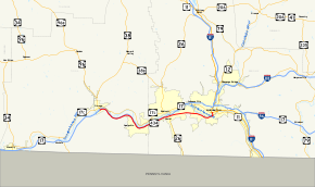
Map of the Binghamton area with NY 434 highlighted in redRoute information Maintained by NYSDOT and the city of Binghamton Length: 20.89 mi[2] (33.62 km) Existed: January 1, 1970[1] – present Major junctions West end:  NY 96 in Owego
 NY 26 near Endicott
 NY 201 near Johnson City
East end:  US 11 in Binghamton
Location Counties: Tioga, Broome Highway system Numbered highways in New York
Interstate • U.S. • N.Y. (former) • Reference • County←  NY 433
NY 436  →
→←  NY 187
NY 189  →
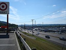
→New York State Route 434 (NY 434) is a state highway located in the Southern Tier of the U.S. state of New York. The route extends for 20.89 miles (33.62 km) from an intersection with NY 96 in the village of Owego to an intersection with US 11 in the city of Binghamton. In between, NY 434 passes through the towns of Owego and Vestal. The portion of NY 434 from the Tioga–Broome County line to downtown Binghamton is known as Vestal Parkway.
NY 434 is the former route of NY 17 prior to the construction of the Southern Tier Expressway (STE), which NY 434 parallels. The portion of the expressway from Owego to Johnson City opened in 1969, at which time NY 17 was realigned to follow the STE from Owego to Vestal and NY 17's former routing between the two locations was redesignated as New York State Route 188. However, in October 1969, NY 188 was renumbered to NY 434 as the New York State Department of Transportation believed that the 188 designation would lead to confusion with the then-future Interstate 88 (abbreviated I-88) northeast of Binghamton. One month later, the portion of former NY 17 between Owego and the Tioga–Broome County line was removed from the state highway system.
The NY 434 designation was officially assigned on January 1, 1970, and initially extended from the Tioga–Broome County line to Vestal. It was extended eastward to downtown Binghamton by 1973 following the completion of the STE between Johnson City and Binghamton and westward to Owego in the late 1970s after NY 17's former routing from Owego to the county line was re-added to the state highway system.
Contents
Route description
History
Origins
When the first set of posted routes in New York were assigned in 1924, what is now NY 434 was designated as part of NY 17, a cross-state highway connecting Erie, Pennsylvania, to New York City.[3] In the mid-1960s, construction began on the portion of the Southern Tier Expressway (STE) between the village of Owego and the city of Binghamton.[4][5] The segment from Owego to Johnson City was completed and opened to traffic in 1969, with the portion from Owego to Vestal becoming a realignment of NY 17.[6]
Initially, the New York State Department of Transportation (NYSDOT) designated the former routing of NY 17 from Owego to NY 26 in Vestal as NY 188. However, on October 10, 1969, NYSDOT announced that they had elected to designate the highway as NY 434 instead, even though signage for NY 188 had already been erected. The state cited potential confusion between NY 188 and the then-future Interstate 88 (I-88) northeast of Binghamton as its reason for the change. At the same time, NYSDOT stated that the NY 434 designation would only extend as far west as the Tioga–Broome County line even though NY 188 had continued to Owego. Instead, the state planned on transferring ownership and maintenance of former NY 17 from Owego east to the county line to Tioga County.[6] This transaction was completed on November 24, 1969.[7]
Designation and extensions
NY 434 was officially assigned on January 1, 1970, as part of a wide-scale update of NYSDOT's Official Description of Touring Routes in New York State. A list of changes accompanying the log described NY 434 as "a new number assigned to replace former NY 17 between the Broome–Tioga County line and NY 26 in Vestal." At the time, NY 434 also ended at NY 17 in Vestal.[1] Although the STE was open from Vestal to Johnson City, it was not slated to become part of NY 17 until the segment of the STE from Johnson City to Interstate 81 was completed. As a result, NY 17 exited the STE at Vestal, overlapped NY 26 south to Vestal Parkway, and followed its original alignment along Vestal Parkway into downtown Binghamton.[6] The Johnson City – I-81 piece of the expressway was completed and opened to traffic by 1973. NY 17 was realigned to follow the STE while NY 17's former routing from Vestal to Binghamton became an extension of NY 434.[8] Like the NY 17 realignment, the NY 434 extension had been planned years before.[6]
The former routing of NY 17 in Tioga County between Owego and the eastern county line remained a county route through at least the mid-1970s. However, in the late 1970s,[9][10] the Tioga County Legislature drafted a resolution that, if passed, would return jurisdiction of the highway to the state of New York.[7] It was passed by 1980, at which point the state of New York reacquired the highway and made it a westward extension of NY 434.[7][10]
Major intersections
County Location Mile[2] Destinations Notes Tioga Village of Owego 0.00  NY 96
NY 960.15  NY 17
NY 17Exit 64 (NY 17) Town of Owego 1.80  NY 17
NY 17Exit 65 (NY 17)  NY 962J
Hamlet of Apalachin; western terminus of NY 962J 7.26  NY 17
NY 17Exit 66 (NY 17) Broome Vestal 13.30  NY 26
NY 26Parclo interchange 17.01  NY 201
Trumpet interchange; southern terminus of NY 201 Binghamton 20.56  NY 363
Southern terminus of NY 363 20.89  US 11
US 111.000 mi = 1.609 km; 1.000 km = 0.621 mi References
- ^ a b State of New York Department of Transportation (January 1, 1970) (PDF). Official Description of Touring Routes in New York State. http://www.greaternyroads.info/pdfs/state70.pdf. Retrieved October 5, 2009.
- ^ a b "2008 Traffic Data Report for New York State" (PDF). New York State Department of Transportation. June 16, 2009. p. 314. https://www.nysdot.gov/divisions/engineering/technical-services/hds-respository/NYSDOT_Traffic_Data_Report_2008.pdf. Retrieved October 5, 2009.
- ^ "New York's Main Highways Designated by Numbers". The New York Times: p. XX9. December 21, 1924.
- ^ Sinclair (1964). New York and Metropolitan New York (Map). Cartography by Rand McNally and Company.
- ^ Esso (1968). New York (Map). Cartography by General Drafting (1969–70 ed.).
- ^ a b c d "On Renumbering Route 17: How State Uses New Math". The Evening Press (Binghamton, New York). October 10, 1969.
- ^ a b c New York State Legislature. "New York State Highway Law § 341". http://public.leginfo.state.ny.us/menugetf.cgi?COMMONQUERY=LAWS. Retrieved October 5, 2009.
- ^ Shell (1973). New York (Map). Cartography by H.M. Gousha Company (1973 ed.).
- ^ Exxon (1977). New York (Map). Cartography by General Drafting (1977–78 ed.).
- ^ a b Pennsylvania Department of Transportation (1980) (PDF). Commonwealth of Pennsylvania Official Transportation Map (Map). ftp://ftp.dot.state.pa.us/public/pdf/BPR_pdf_files/Maps/Statewide/Historic_OTMs/1980fr.pdf. Retrieved October 5, 2009.
External links
Categories:- Binghamton, New York
- State highways in New York
- Interstate 86 (east)
- Transportation in Broome County, New York
- Transportation in Tioga County, New York
Wikimedia Foundation. 2010.


