- New York State Route 97
-
NYS Route 97
Route information Maintained by NYSDOT and the city of Port Jervis Length: 70.53 mi[2] (113.51 km) Existed: 1930[1] – present Major junctions South end: 

 US 6 / US 209 / NY 42 in Port Jervis
 NY 52 in Tusten
North end:  NY 17 in Hancock
Location Counties: Orange, Sullivan, Delaware Highway system Numbered highways in New York
Interstate • U.S. • N.Y. (former) • Reference • County←  NY 96B
NY 98  →
→New York State Route 97 (NY 97) is a 70.53-mile (113.51 km) north–south scenic route in southern New York, United States. It runs from U.S. Route 6 and US 209 in Port Jervis to NY 17 in Hancock. Its most famous feature is the Hawk's Nest, a tightly winding section of the road along the Delaware River, located a few miles north of Port Jervis. NY 97 intersects NY 52 in Narrowsburg and indirectly connects to three Pennsylvania state highways due to its proximity to the state line.
The New York State Legislature created Route 3-a, an unsigned legislative route extending from Port Jervis to Hancock along the Delaware River, in 1911. Initially, it was a route in name only as the portion north of Port Jervis had yet to be built. Several parts of the route were constructed during the 1920s, and by the time the NY 97 designation was created as part of the 1930 renumbering of state highways in New York, only two sections were still unconstructed. The entirety of the highway officially opened on August 30, 1939, capping a construction project that cost $4 million (equivalent to $63.3 million in 2011) to complete.
NY 97 began in the Port Jervis and ended in Callicoon when it was assigned in 1930. At that time, the remainder of modern NY 97 was part of NY 17B. NY 97 was extended north to Hancock in 1939, overlapping NY 17B. The latter route was truncated to Callicoon in the 1960s. It is also shared with New York State Bicycle Route 17, except between NY 17 and NY 268.[3][4]
Contents
Route description
Orange County
Route 97 begins, along with NY 42, at an intersection in Port Jervis where Park Avenue reaches US 6 and US 209. NY 42 and 97 within the city of Port Jervis is maintained by the city. After passing through a residential neighborhood, the road climbs a nearby hillside and offers some stunning views back over the city, then leaves it. The road here runs right next to the active Central New York Railroad.
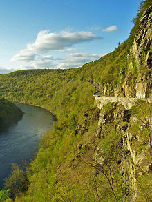
A few miles further on, the two routes split at the hamlet of Sparrow Bush. After passing through a wooded area and climbing some more, the road opens on to its most scenic portion, Hawk's Nest.
Here 97 perches on steep and stony cliffs, following a narrow, twisty course. Picturesque stone fencing prevents cars from falling into the river a hundred feet (30 m) below, and there are frequent overlooks to take in the view and, on nice summer days, the kayakers and rafters. It has been used in commercials for BMW, Honda, Mercedes-Benz, Saab and Cadillac models, as well as by American Express. Car and motorcycle enthusiasts, and more recently bicyclists and even skateboarders, have been drawn to the Hawk's Nest's combination of scenic beauty and challenge for many years.
Once past the Hawk's Nest, 97 again returns to river level as it crosses the Mongaup River and enters Sullivan County.
Sullivan County
Here the road runs more east–west, as does the river. Highway and the railroad tracks are never far away as 97 winds past several small hamlets that grew up around the railroad. In the slightly larger hamlet of Barryville, 97 meets its first state highway since Sparrow Bush as NY 55 crosses the highway on its way into Pennsylvania where it becomes that state's Route 434.
Continuing on past land mostly undeveloped as part of the Upper Delaware Scenic and Recreational River, 97 passes more small hamlets. Shortly after Minisink Ford and the restored Roebling's Delaware Aqueduct, the river turns northward again and so does 97. However, the highway strikes a course more inland, with more than a mile separating it from the river at Luxton Lake. The NY 52 junction heralds a return to the river route, however, and shortly thereafter 97 comes upon Narrowsburg, the largest community it will pass through between its termini (while still small). A bridge leads across to Darbytown and PA 652.
Having returned to the side of the Delaware, 97 hugs it closely up to Cochecton, where the old Newburgh-Cochecton Turnpike once reached the river and a bridge gives access to Damascus and PA 371. 97 goes on to Callicoon and its last state highway junction in Sullivan County, NY 17B. It avoids a bend in the river north of the quiet hamlet by heading more to the north, then rejoins the river past Hankins and Long Eddy until it reaches the Delaware County line.
Delaware County
In Delaware 97 again moves away from the river and finds some stretches more like other state highways and less like a river road, with long straightaways, wide turns, good pavement and gentle climbs. A few miles south of Hancock, 97 returns to the river and follows it past the confluence of its east and west branches and then enters the village. There, it collects PA 191 and ends at a junction with NY 17. The highway continues north as Delaware County Route 67 (Sands Creek Road) to end at NY 10.
History
The Delaware River corridor had been linked by a road along the cliffs overlooking the river since at least 1851.[citation needed] However, when the plans for a new highway through the corridor were initially drawn up, it was to bypass what became the Hawk's Nest in favor of a shoreline route.[citation needed] However, the Erie Railroad refused to sell the necessary right-of-way, forcing the state to construct the improved road along the cliffside instead.[citation needed]
In 1911, the New York State Legislature created Route 3-a, an unsigned legislative route extending from the Pennsylvania state line at Port Jervis to Route 4 (later NY 17) in Hancock along the Delaware River.[5] Very little of this highway actually existed in reality; by 1920, only 3.69 miles (5.94 km) of the 62.27-mile (100.21 km) long route had been built.[6] In the 1930 renumbering of state highways in New York, the segment of former Route 3-a from Port Jervis to Callicoon was designated as NY 97, even though two sections of the route—between NY 42 at Sparrow Bush and Mongaup and from Pond Eddy to near the hamlet of Tusten—were still incomplete. The remainder of old Route 3-a north of Callicoon, which was fully constructed by 1930, became part of NY 17B.[1][7] In 1932, then-Governor Franklin D. Roosevelt signed legislation designating NY 97 as the "Upper Delaware Scenic Byway".[citation needed]
On August 30, 1939, the entirety of NY 97 was officially opened to traffic. Several events were held to mark the road's opening, including a ribbon-cutting ceremony in Port Jervis featuring the mayors of Port Jervis and Hancock and a motorcade procession that traveled the length of the highway. In all, it cost $4 million[8] (equivalent to $63.3 million in 2011)[9] to build NY 97. The portion through the Hawk's Nest cost $2 million[8] (equivalent to $31.6 million in 2011)[9] to construct.[8] Following the road's completion, NY 97 was extended north to Hancock, overlapping NY 17B.[8][10][11] The overlap was eliminated in the mid-1960s when NY 17B was truncated to Callicoon.[12][13]
Near Cochecton, a historical marker points out that Route 97 passes the rock claimed by New Jersey colonists as the western end of the colony's northern border during the New York - New Jersey Line War in the 18th century.[citation needed] About a quarter of the route follows the old Delaware and Hudson Canal.[citation needed]
Major intersections
County Location Mile[2] Destinations Notes Orange Port Jervis 0.00 US 6 / US 209 / NY 42Southern terminus of NY 42 / NY 97 overlap; southern terminus of NY 42 Deerpark 2.95 NY 42 northHamlet of Sparrow Bush; northern terminus of NY 42 / NY 97 overlap Sullivan Highland 18.38 
 NY 55 / PA 434
Hamlet of Barryville; western terminus of NY 55; eastern terminus of PA 434[a] Tusten 32.21 NY 52 eastEastern terminus of NY 52 / NY 97 overlap 32.97 NY 52 westHamlet of Narrowsburg; western terminus of NY 52 / NY 97 overlap Cochecton 41.86  To PA 371 via CR 114
Delaware 46.29  NY 17B
Hamlet of Callicoon; western terminus of NY 17B Delaware Village of Hancock 69.44  NY 268
Southern terminus of NY 268  PA 191
Northern terminus of PA 191[a] 70.53 NY 17Exit 87 (NY 17) 1.000 mi = 1.609 km; 1.000 km = 0.621 mi Notes
- a. ^ a b The actual eastern terminus of PA 434 and the actual northern terminus of PA 191 is at the New York – Pennsylvania border in the middle of the Delaware River roughly 400 yards (370 m) from where their locally-maintained continuations into New York intersect NY 97.
References
- ^ a b Pennsylvania Department of Highways (1930) (PDF). Tourist Map of Pennsylvania (Map). ftp://ftp.dot.state.pa.us/public/pdf/BPR_pdf_files/Maps/Statewide/Historic_OTMs/1930fr.pdf. Retrieved May 24, 2009.
- ^ a b "2008 Traffic Volume Report for New York State" (PDF). New York State Department of Transportation. June 16, 2009. pp. 154–155. https://www.nysdot.gov/divisions/engineering/technical-services/hds-respository/NYSDOT%20TVR%202008%20by%20Route.pdf. Retrieved January 31, 2010.
- ^ New York State Route Bicycle Route 17 (Delaware County)
- ^ New York State Route Bicycle Route 17 (Sullivan County)
- ^ State of New York Commission of Highways (1919). The Highway Law. Albany, New York: J. B. Lyon Company. p. 68. http://books.google.com/books?id=hZ4AAAAAMAAJ&printsec=frontcover#PPA68,M1. Retrieved May 24, 2009.
- ^ New York State Department of Highways (1920). Report of the State Commissioner of Highways. Albany, New York: J. B. Lyon Company. p. 501. http://books.google.com/books?id=Sj4CAAAAYAAJ&printsec=titlepage#PPA501,M1. Retrieved May 24, 2009.
- ^ Dickinson, Leon A. (January 12, 1930). "New Signs for State Highways". The New York Times: p. 136.
- ^ a b c d "Open New Highway on the Delaware". The New York Times: p. 24. August 31, 1939.
- ^ a b Consumer Price Index (estimate) 1800–2008. Federal Reserve Bank of Minneapolis. Retrieved December 7, 2010.
- ^ Thibodeau, William A. (1938). The ALA Green Book (1938–39 ed.). Automobile Legal Association.
- ^ Gulf Oil Company (1940). New York Info-Map (Map). Cartography by Rand McNally and Company.
- ^ Sinclair (1964). New York and Metropolitan New York (Map). Cartography by Rand McNally and Company.
- ^ Esso (1968). New York (Map). Cartography by General Drafting (1969–70 ed.).
External links
Categories:- State highways in New York
- Delaware River
- Transportation in Orange County, New York
- Transportation in Sullivan County, New York
- Transportation in Delaware County, New York


Wikimedia Foundation. 2010.