- Pennsylvania Route 371
-
PA Route 371
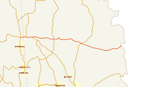
Route information Maintained by PennDOT Length: 23.45 mi[1] (37.74 km) Existed: 1936 – present Major junctions West end: 
 PA 171 / PA 374 near Union Dale
 PA 670 in Mount Pleasant Township
 PA 247 in Niagara
 PA 191 in Lebanon Township
East end:  CR 114 at New York state line in Damascus Township
Location Counties: Susquehanna, Wayne Highway system Roads in Pennsylvania
Interstate • US • State • Legislative←  PA 370
PA 372  →
→Pennsylvania Route 371 (designated by the Pennsylvania Department of Transportation as SR 0371) is a 23.45-mile (37.74-kilometer) long state highway located in Susquehanna and Wayne Counties. The western terminus is at Route 171 / Route 374 near the community of Union Dale in Herrick Center. The eastern terminus is the New York state line in Damascus Township on the Delaware River. It continues as Sullivan County Route 114 in New York towards New York State Route 97.
Route 371 originates as a road cut in 1791 and later used for the Newburgh and Cochecton Turnpike in 1806. The new turnpike was finished in 1811 and renamed as the Great Bend and Newburgh Turnpike in accordance for the extension to Great Bend, Pennsylvania. The turnpike was abandoned in 1853. Route 371 was originally designated along the turnpike route in 1936 by the Department of Highways from Great Bend to Damascus. The route remained intact until 1954, when the route was truncated back to Route 171 in Herrick Center. The route was replaced by Route 374 and Route 848 in 1961.
Contents
Route description
Pennsylvania Route 371
Route 371 begins at an intersection with Pennsylvania Route 171 and Pennsylvania Route 374 in the community of Herrick Center. The route heads eastward, progressing through rural forests north of Union Dale. Route 371 begins in Susquehanna County, but just a short distance from Herricks Center, crosses into Wayne County. The route heads to the east, but soon begins to curve to the north, entering the community of Belmont Corners. Route 371 becomes known as the Great Bend Turnpike, leaving Belmont Corners at an intersection with Pennsylvania Route 670 (Belmont Turnpike). At the intersection, Route 371 and Route 670 bcomes concurrent for a distance. The routes head eastward through the forests in northern Wayne County. A short distance later, Routes 371 and 670 enter the community of Pleasant Mount, where the alignment becomes surrounded by residences.[1]
In Pleasant Mount, Routes 371 and 670 head eastward as the main street in the community until a split at the eastern end of the community. There, Route 371 continues eastward along the Great Bend Turnpike while Route 670 forks to the southeast along the Bethany Turnpike. Route 371 heads eastward through fields until an intersection with "Crossroad", where it turns to the southeast towards the center of Mount Pleasant Township. The highway continues on the southeast pattern for a distance, past a large farm and into more forests nearby. At an intersection with Bush Road, Route 371 changes direction, heading to the northwest along the Turnpike. A short distance later, the highway heads through the rural farmlands until entering the community of Niagara. In the small community, the highway intersects with Pennsylvania Route 247, where they start a short concurrency. The two routes head northward for a short distance, until Route 371 splits to the east.[1]
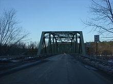 Cochecton–Damascus Bridge, the dividing line between PA 371 and Sullivan CR 114
Route 371 continues eastward through the rural regions, continuing its way through Mount Pleasant Township. The highway intersects with Township Road 613, where the highway makes a hairpin turn to the south. The route continues to the southeast into a denser portion of Lebanon Township. The route continues for a distance to the east until an intersection with Lebanon Township Road 614 in the community of Cold Spring. In Cold Spring, Route 371 turns to the southeast through deep forests until an intersection with Township Roads 612 and 617. There, the forests break, and the route continues to the southeast. A short distance later, Route 371 intersects with Pennsylvania Route 191 (Hancock Highway) in the community of Rileyville. There, the route begins to follow the alignment of the Newburgh and Cochecton Turnpike. Route 371 continues through rural farmlands until a hairpin turn in the deep forests nearby.[1]
After leaving the deep forests, the route re-emerges in Damascus Township's community of West Damascus. The route heads to the southeast even further into Fallsdale, where it passes two large ponds and several athletic fields. At the end of the eastern pond, Route 371 turns to the northeast crossing a creek and into the community of Tyler Hill. The route heads to the northeast through a small developed portion of the community before turning to the southeast and soon to the northeast again. The route continues to the northeast for a short distance before reaching the Delaware River, where PA 371 ends at the New York state line on the Cochecton–Damascus Bridge and continuing as Sullivan County Route 114.[1]
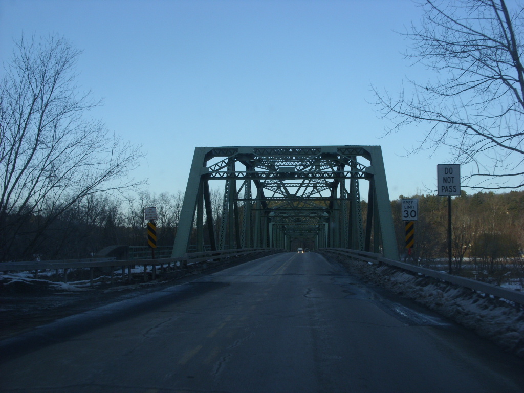
 Route 114, signed as County Route 114W just after the bridge from Damascus
Sullivan County Route 114
Upon crossing the state line, Pennsylvania Route 371 continues as Sullivan County Route 114. After leaving the Cochecton–Damascus Bridge, Route 114 heads through the small community of Cochecton, New York, which is developed, mostly by farmland and local homes. A short distance later, the highway crosses over the Erie Railroad, turning to the north which starts a parallel. The route heads northward through a small residential district before making a gradual turn to the east along a bend in the Delaware River. A short distance after the turn the right-of-way ends at an intersection with New York State Route 97. County Route 114, however, continues along a short concurrency towards Fosterdale. [2]
History
Old roads
Records indicate that the alignment of Route 371 was first constructed as a cut from the Delaware River to the community of Great Bend, Pennsylvania in 1791 through Wayne and Susquehanna Counties. In 1801, the state legislature of New York and Pennsylvania brought up the proposal for the Newburgh and Cochecton Turnpike (later the Great Bend and Newburgh Turnpike) to connect the Hudson River to the Delaware River.[3] Although the route was finished in New York, the portion in Pennsylvania was not legislated until March 29, 1804.[4] Construction through Wayne and Susquehanna Counties commenced in 1806, with completion of the roadway coming in 1811.[5] At that point, the turnpike was extended onto the cut in Pennsylvania to the Susquehanna River. The turnpike was used for transportation of farmers' goods and stock along with a route for pioneers to use for heading westward.[3] After construction of the original Cochecton–Damascus Bridge in 1817 (and later in 1821),[6] the area around the bridge became a bustling community. The alignment of what is now Route 371 eventually became littered with a large rate of development, with nineteenth-century style buildings constructed in Damascus. The turnpike itself fared poorly later on, and was abandoned in 1853. Although the roadway itself was abandoned, the turnpike corporation that was supposed to maintain the roadway remained intact until 1868, when it was dissolved. Even afterwards, the roadway remained the only physical route in the area until at least the 1890s.[3]
On August 14, 1992, the stretch of Route 371 from Galilee Road to the Delaware River was entered into the National Register of Historic Places as the Damascus Historic District. The record for the National Register included the roadway and forty different structures along the roadway for its historical significance.[7]
Designation
Originally, a short portion of Route 371 was part of Pennsylvania Route 170 in the 1928 mass numbering of state highways in Pennsylvania.[8] 83 years after the abandonment of the Great Bend and Newburgh Turnpike (1936), the Pennsylvania Department of Highways took over the alignment of the highway for the designation of Legislative Route 371. The route at that point began at an intersection of U.S. Route 11 in Great Bend to the state line on the Delaware River in Damascus.[9] The route remained intact along the turnpike for only eighteen years when in 1954, the Department of Highways truncated Route 371 back to the intersection with Route 171 in the community of Herrick Center.[10] Seven years later, the Department of Highways designated both Pennsylvania Route 374 on the alignment from Royal to Herrick Center and Pennsylvania Route 848 from the community of New Milford (south of Great Bend) to Gibson.[11]
Major intersections
County Location Mile[2] Destinations Notes Susquehanna Herrick Township 0.00 PA 171 / PA 374Eastern terminus of PA 374. Western terminus of PA 371. Wayne Mount Pleasant Township 1.33 PA 670Begin/end concurrency with PA 670 2.49 PA 670Begin/end concurrency with PA 670 Niagara 7.31 PA 247Begin/end concurrency with PA 247 7.45 PA 247Begin/end concurrency with PA 247 Lebanon Township 14.28 PA 191 (Hancock Highway)Damascus Township 23.45 CR 114Cochecton–Damascus Bridge. Eastern terminus of PA 371 1.000 mi = 1.609 km; 1.000 km = 0.621 mi See also
References
- ^ a b c d e Yahoo! Inc. Yahoo! Maps – Overview map of Pennsylvania Route 371 (Map). Cartography by NAVTEQ. http://maps.yahoo.com/#mvt=h&lat=41.71662&lon=-75.273735&zoom=12&q1=41.740281%2C-75.480718&q2=41.704983%2C-75.066778. Retrieved August 17, 2009.
- ^ a b Yahoo! Inc. Yahoo! Maps – Overview map of Sullivan County Route 114 (Map). Cartography by NAVTEQ. http://maps.yahoo.com/#mvt=h&lat=41.70819&lon=-75.0624&zoom=17&q1=41.704982%2C-75.066674&q2=41.711261%2C-75.058091. Retrieved August 20, 2009.
- ^ a b c "Damascus Historic District". The Living Group. 2009. http://www.livingplaces.com/PA/Wayne_County/Damascus_Township/Damascus_Historic_District.html. Retrieved November 2, 2009.
- ^ Hazzard, Samuel (1829). The Register of Pennsylvania: devoted to the preservation of facts and documents and every other kind of useful information respecting the state of Pennsylvania. W.F. Geddes. pp. 137. http://books.google.com/books?id=7XcFAAAAQAAJ&pg=PA137&lpg=PA137&dq=Great+Bend+and+Newburgh+Turnpike&source=bl&ots=6tSS1muRo7&sig=24GBZn7309w7x1c4LV0x_fWT-I4&hl=en&ei=lFzvSvXTE9HulAfqwPX_BA&sa=X&oi=book_result&ct=result&resnum=8&ved=0CCUQ6AEwBw#v=onepage&q=Great%20Bend%20and%20Newburgh%20Turnpike&f=false. Retrieved November 2, 2009.
- ^ Blackman, Emily C. (1873). History of Susquehanna County, Pennsylvania: from a period preceding its settlement to recent times. Claxton, Remsen, & Haffelfinger. pp. 510. http://books.google.com/books?id=Hao-AAAAYAAJ&pg=RA4-PA510&dq=Great+Bend+and+Newburgh+Turnpike&ei=ql3vSr2REaKKygSPy6CrAw&client=firefox-a#v=onepage&q=Great%20Bend%20and%20Newburgh%20Turnpike&f=false. Retrieved November 2, 2009.
- ^ Dale, Frank T. Bridges Over The Delaware River: A History of Crossings. New Brunswick: Rutgers University Press, 2003. ISBN 0813532132.
- ^ Historic Places, National Register (August 14, 1992), Damascus Historic District, Washington D.C.: National Park Service
- ^ Pennsylvania Department of Highways (1928). Map Showing Pennsylvania State Highways (Map).
- ^ Pennsylvania Department of Highways (1936). Map Showing Pennsylvania State Highways (Map).
- ^ Pennsylvania Department of Highways (1954). Pennsylvania Official Road Map (Map).
- ^ Pennsylvania Department of Highways (1961). Pennsylvania Official Road Map (Map).
External links
- Kitsko, Jeffrey J. (2009). "PA 371". Pennsylvania Highways. http://www.pahighways.com/state/PA351-400.html#PA371. Retrieved August 17, 2009.
- Prince, Adam J. (2005). "PA 371". State-Ends.com. http://www.state-ends.com/paends/state/371.html. Retrieved November 2, 2009.
Categories:- State highways in Pennsylvania
- Transportation in Susquehanna County, Pennsylvania
- Transportation in Wayne County, Pennsylvania


Wikimedia Foundation. 2010.