- Pennsylvania Route 191
-
PA Route 191
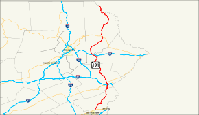
Route information Maintained by PennDOT Length: 111.54 mi[1] (179.51 km) Existed: 1961 – present Major junctions South end:  US 22 in Brodhead, PA
 PA 33 in Stockertown

 I-80/US 209 in Stroudsburg
 I-84 in Sterling Township
 US 6 in Honesdale
North end: 
 To NY 97 at New York state line at Hancock, NY
Location Counties: Northampton, Monroe, Pike, Wayne Highway system Roads in Pennsylvania
Interstate • US • State • Legislative←  PA 190
PA 192  →
→←  I-90
I-90
PA 91  →
→Pennsylvania Route 191 is a 111.54 mi (179.51 km)-long state highway in the U.S. state of Pennsylvania. The route, a major non-freeway corridor connecting the Lehigh Valley to The Poconos in eastern Pennsylvania, is designated from U.S. Route 22 in Brodhead to the New York state line over the Delaware River at Hancock, New York.
Commissioned in 1961, the route replaced the PA 12 and PA 90 numbers that were in place from the late 1920s to the 1960s. From 1961 to 1976, PA 191 was routed south of US 22 through Bethlehem and terminated at Pennsylvania Route 309 in Center Valley. Pennsylvania Route 378 replaced the designation from Center Valley to the Lehigh River crossing in Bethlehem.
Contents
Route description
Northampton County
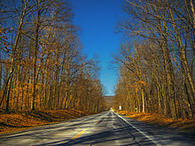 Pennsylvania Route 191 passes through the woods of Washington Township
Route 191 begins at an interchange with U.S. Route 22 in Bethlehem Township, as the Nazareth-Bethlehem Pike, a continuation of Linden Street from downtown Bethlehem. From there, PA 191 runs north-east past some rural and agricultural regions of Northampton County. Along the way, it intersects the eastern terminus of Pennsylvania Route 946 in Lower Nazareth Township.
Route 191 runs west of Nazareth Speedway, at the southern tip of Nazareth. The road enters the small borough from the south, while overlapping Pennsylvania Route 248 for one block. North of 248, Route 191 runs northward as Broad Street for three blocks and turns east onto Center Street for one block. The route then turns northward onto New Street in the northern sectors of Nazareth.
Outside of the borough, Route 191 is referenced as East Lawn Avenue, running eastward. Lawn Avenue becomes Industrial Boulevard where Route 191 interchanges Pennsylvania Route 33. The route turns north onto Main Street, then northeast on Bangor Road in Stockertown. The route traverses several hills and more rural land in Washington Township. Between Stockertown and Bangor the road runs northeast. In Bangor, Route 191 becomes 1st Street, while intersecting Pennsylvania Route 512.
Outside of Bangor, Route 191 is known as Valley View Drive. The road traverses the Blue Mountain range at the Northampton-Monroe county line.[2]
Monroe and Pike Counties
Route 191 enters the county at the summit of Blue Mountain as Godfrey Ridge Road. Upon entering Stroudsburg as Broad Street, the road intersects Pennsylvania Route 611. Traffic from 611 north has access only to I-80 east and US 209 northbound. Traffic from 191 north has access to I-80 west and US 209 southbound.
North of the I-80 overpass in downtown Stroudsburg, Route 191 intersects U.S. Route 209 Business, split into one-way couplets. Route 191 departs the downtown area as 5th Street, running north and entering a more mountainous region of The Poconos. In the northern suburbs of the borough, the route briefly overlaps Pennsylvania Route 447 along the western banks of the Brodhead Creek. North of the 447 overlap, 191 intersects Pennsylvania Route 715, while the elevation along Route 191 rises northward. In Paradise Valley, the road turns north north at the eastern terminus of Pennsylvania Route 940.
Route 191 then begins an overlap with Pennsylvania Route 390. The overlap ends in Mountainhome and 191 runs northwest along Chestnut Mountain. In Pike County, the route is known as La Anna Road for less than a mile.[2]
Wayne County
In the upper regions of The Poconos, Route 191 enters the final county of its course – Wayne. The route enters the county in South Sterling, where it intersects the northern terminus of Pennsylvania Route 423. Route 191 overlaps Pennsylvania Route 507 in the village of Newfoundland; Pennsylvania Route 447 terminates at the overlap. Away from the overlap with 507, Route 191 runs northwest. In the small village of Collapoose, 191 interchanges with Interstate 84, at exit 17.

Briefly north of I-84, Route 191 begins a concurrency with Pennsylvania Route 196. In Hamlin, the overlap intersects Pennsylvania Route 590. North of the village, Route 191 runs northeast from 196. In Lake Ariel, Pennsylvania Route 296 terminates at 191. Outside of the hamlet, Route 191 runs northeast as the Lake Ariel Highway.
In Honesdale, Route 191 enters the borough as Erie Street. Main Street, the main arterial of Honesdale, serves as the overlap for U.S. Route 6 and Route 191, for two blocks. North of the overlap, 191 intersects the southern end of Pennsylvania Route 670. Outside of Honesdale, Route 191 runs northeast, traversing mostly mountainous and rural land. In Rileyville, Route 191 becomes the Hancock Highway and intersects Pennsylvania Route 371. The Hancock Highway continues northward and begins to parallel the Delaware River.
Pennsylvania Route 370, is the final junction of the route in Pennsylvania, approximately two to four miles (6 km) southeast of Hancock, New York. The Hancock Highway becomes Pennsylvania Avenue, as Route 191 crosses the Delaware River and enters New York. In Hancock, the short Pennsylvania Avenue intersects New York State Route 97, less than a mile from exit 87 of New York State Route 17.[2]
History
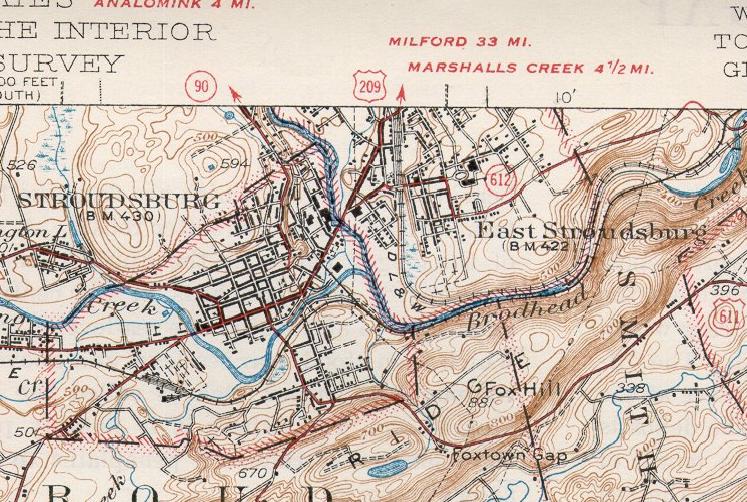
 1942 map of Stroudsburg showing Route 191 as Route 90.
In the 1920s and 1930s, the first 191 number was designated from the Baltimore Pike in Clifton Heights to Penrose Avenue in southwest Philadelphia.[3] The first state highway numbers to be assigned on the modern Route 191 were Pennsylvania Route 12 and Pennsylvania Route 90. PA 90 was designated from Stroudsburg to the New York-Pennsylvania border. PA 12 was designated from Center Valley to Stockertown. From the 1920s to the 1940s, the designation between Stockertown and Stroudsburg had no signed traffic route.[4] When both routes were commissioned, several spurs were as well. For Route 90, the following spurs were assigned in The Poconos region: Pennsylvania Routes 190, 290, 390, 490, and 590. For Route 12, the following spurs were assigned in The Poconos and Lehigh Valley regions: Pennsylvania Routes 212, 312, 412, 512, 612, and 712.[5]
By 1950, PA 90 was designated on the missing non-numbered gap between Stroudsburg and Stockertown.[6] In 1961, Route 191 was commissioned from the New York state line to U.S. Route 309 in Center Valley. The route replaced the entire designations of PA 12 and PA 90. In Bethlehem, PA 191 was designated onto Wyandotte Street, crossed the Lehigh River, went onto Main Street, turned onto Elizabeth Avenue, and turned onto Linden Street or Nazareth-Bethlehem Pike north of the city.[7]
By 1970, when Pennsylvania Route 378 was commissioned, PA 191 moved designations slightly in Bethlehem. Southbound 191 came from Nazareth, as Linden Street, and in Bethlehem, it turned west onto Union Boulevard. After it passed underneath I-378, the route turned south onto 3rd Street then onto the I-378 freeway. I-378 terminated at the bridge that crosses the Lehigh River and it continued as PA 191 (Wyandotte Street). By 1976, PA 191 was truncated to end at its current location and Pennsylvania Route 378 (formerly I-378) replaced its former routing from the Lehigh River bridge to Pennsylvania Route 309 in Center Valley.[8][9]
Major intersections
County Location Mile[1] Destinations Notes Northampton Bethlehem Township 0.00 US 22 (Lehigh Valley Thruway)Interchange. Continues south of Route 22 as Linden Street into Bethlehem. Lower Nazareth Township 1.98  PA 946
Eastern terminus of PA 946. Nazareth 4.27  PA 248
Southern terminus of concurrency. 4.48 PA 248Northern terminus of concurrency. Stockertown 7.50 PA 33Interchange. 7.70 Main Street (SR 2025) Bangor 16.93  PA 512
Monroe Stroudsburg 26.03  PA 611
26.46 I-80 / US 209Exit 307 (I-80/US 209). 26.52 

US 209 BUSSouthern terminus of concurrency. 26.63
US 209 BUSNorthern terminus of concurrency. Stroud Township 30.55  PA 447
Southern terminus of concurrency. 33.05 PA 447Northern terminus of concurrency. Paradise Township 35.41  PA 715
Northern terminus of PA 715. 38.37  PA 940
Eastern terminus of PA 940. 39.91  PA 390
Southern terminus of concurrency. Barrett Township 41.97 PA 390Northern terminus of concurrency. Pike No junctions Wayne Dreher Township 50.52  PA 423
Northern terminus of PA 423. 53.42  PA 507
Southern terminus of concurrency. 54.79 PA 447Northern terminus of PA 447. 55.22 PA 507Northern terminus of concurrency. Sterling Township 59.42 I-84Exit 17 (I-84). 60.33  PA 196
Southern terminus of concurrency. Salem Township 63.24  PA 590
64.38 PA 196Northern terminus of concurrency. Lake Ariel 66.90  PA 296
Southern terminus of PA 296. Honesdale 78.42 US 6 (Grand Army Of The Republic Highway)Southern terminus of concurrency. 79.04 US 6 (Grand Army Of The Republic Highway)Northern terminus of concurrency. 79.65  PA 670
Southern terminus of PA 670. Lebanon Township 89.56  PA 371
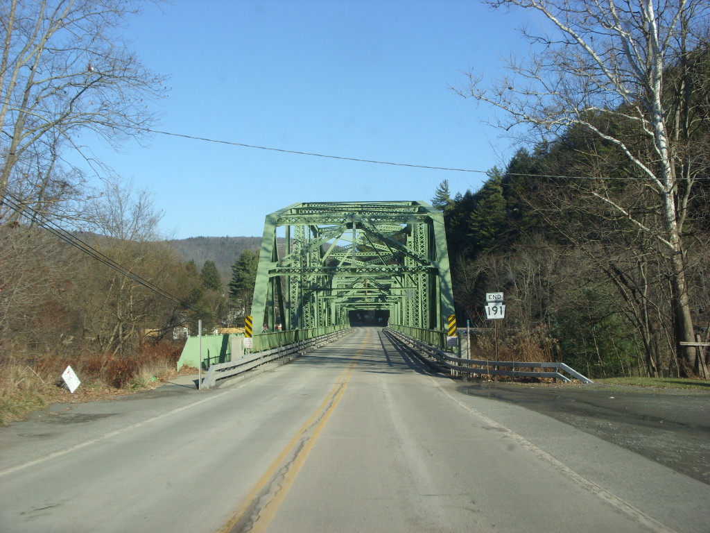
Buckingham Township 110.46  PA 370
Northern terminus of PA 370. The New York state line. 1.000 mi = 1.609 km; 1.000 km = 0.621 mi References
- ^ a b DeLorme Street Atlas USA 2007 software
- ^ a b c Google, Inc. Google Maps – overview map of Route 191 (Map). Cartography by Google, Inc. http://maps.google.com/maps?f=q&hl=en&geocode=&time=&date=&ttype=&q=Pennsylvania+Route+191&sll=37.0625,-95.677068&sspn=28.334641,59.765625&ie=UTF8&ll=41.112469,-75.316772&spn=1.680282,3.735352&z=8&om=1. Retrieved 2007-10-13.
- ^ Pennsylvania Department of Highways (1930). Statewide Map (back) (Map). ftp://ftp.dot.state.pa.us/public/pdf/BPR_pdf_files/Maps/Statewide/Historic_OTMs/1930bk.pdf. Retrieved 2007-10-14.
- ^ Pennsylvania Department of Highways (1929). Eastern Half of map (Map). http://filebox.vt.edu/users/bharper/roads/PA1929e.jpg. Retrieved 2007-10-14.
- ^ Pennsylvania Department of Highways (1940). Statewide Map (Map). ftp://ftp.dot.state.pa.us/public/pdf/BPR_pdf_files/Maps/Statewide/Historic_OTMs/1940fr.pdf. Retrieved 2007-10-14.
- ^ Pennsylvania Department of Highways (1950). Statwide Map (Map). ftp://ftp.dot.state.pa.us/public/pdf/BPR_pdf_files/Maps/Statewide/Historic_OTMs/1950fr.pdf. Retrieved 2007-10-14.
- ^ Pennsylvania Department of Highways (1961). Northampton County Map (Map). ftp://ftp.dot.state.pa.us/public/pdf/BPR_PDF_FILES/Maps/Type_10_GHS_Historical_Scans/Northampton_1961.pdf. Retrieved 2007-10-14.
- ^ Pennsylvania Department of Highways (1970). Statewide Map (back) (Map). ftp://ftp.dot.state.pa.us/public/pdf/BPR_pdf_files/Maps/Statewide/Historic_OTMs/1970bk.pdf. Retrieved 2007-10-14.
- ^ PennDOT (1976). Northampton County Map (Map). ftp://ftp.dot.state.pa.us/public/pdf/BPR_PDF_FILES/Maps/Type_10_GHS_Historical_Scans/Northampton_1976.pdf. Retrieved 2007-10-14.
External links
- Pennsylvania Highways: PA 151 - 200
- PA State Route 191 Ends
- PA Routes 191-200 - Central PA/MD Routes
Transportation infrastructure of the Lehigh Valley Interstates U.S. Routes Pennsylvania Routes New Jersey Routes County Routes Named roads/streets Bridges Albertus L. Meyers Bridge · Hill to Hill Bridge · Philip J. Fahy Memorial Bridge · Minsi Trail Bridge · Easton–Phillipsburg Toll Bridge · Northampton Street Bridge · Interstate 78 Toll Bridge
Tunnels Public transportation Lehigh and Northampton Transportation Authority (Bethlehem Loop) · Trans-Bridge Lines · NJ Transit
Airports Waterways Rail Categories:- State highways in Pennsylvania
- Transportation in Monroe County, Pennsylvania
- Transportation in Wayne County, Pennsylvania
- Transportation in Pike County, Pennsylvania
- Transportation in Northampton County, Pennsylvania


Wikimedia Foundation. 2010.