- Pennsylvania Route 940
-
PA Route 940
Route information Maintained by PennDOT Length: 44 mi[1] (71 km) Existed: 1928 – present Major junctions West end:  PA 309 in Hazleton
 I-80 in East Side

 I-80/I-476/PA Tpk near East Side
 I-380 in Pocono Summit
 PA 611 in Mount Pocono
East end:  PA 191 in Paradise Valley
Location Counties: Luzerne, Carbon, Monroe Highway system Roads in Pennsylvania
Interstate • US • State • Legislative←  PA 938
PA 941  →
→Pennsylvania Route 940 is a 44-mile (71 km) long Pennsylvania highway located in the sparsely-developed Poconos. It runs from Pennsylvania Route 309 in Hazleton to Pennsylvania Route 191 in Paradise Valley. Large segments of PA 940 are located in densely forested areas.
Contents
Route description
Luzerne County
PA 940 begins at an intersection with Pennsylvania Route 309 at the Hazleton city line. PA 940 begins as 22nd Street then makes a 35 degree turn to the northeast. In Hazle Township, PA 940 makes a right angle turns toward the east as Main Street. PA 940 has many turns in Hazle Township. In Freeland, PA 940 becomes Hazle Street then makes a northernly turn to become Centre Street. In downtown Freeland, PA 940 makes a 90 degree turn to the east and becomes South Street. As PA 940 exits the borough of Freeland, PA 940 continues toward the northeast as Foster Avenue. In White Haven, PA 940 becomes Church Street then interchanges with Interstate 80 at exit 273. In downtown White Haven, PA 940 intersects the southern terminus of Pennsylvania Route 437 while making a 90 degree turn toward the east and crosses the Lehigh River.[2]
Carbon County
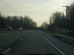 PA 940 at the I-80 interchange.
After crossing the Lehigh River, PA 940 has entered Carbon County and the borough of East Side. After crossing the Lehigh River, PA 940 makes a left turn to the north to become River Street, then curves to the east to become State Street. At the East Side borough boundary, PA 940 intersects the western terminus of Pennsylvania Route 534, the only route to Hickory Run State Park. In Kidder Township, PA 940 interchanges with Interstate 80 and Interstate 476 (N.E. Extension of the Pennsylvania Turnpike) at two trumpet interchanges that meet at PA 940 with traffic lights. East of the interchange, PA 940 goes under I-476/PA Turnpike into the village of Leonardsville.[2]
Monroe County
After crossing the Tobyhanna Creek, PA 940 has entered Monroe County. In Tobyhanna Township, PA 940 intersects Pennsylvania Route 115. In Tobyhanna Township, PA 940 has many S-curves and passes north of Pocono Lake. In the village of Pocono Lake right in front of Lake Naomi, PA 940 intersects the southern terminus of Pennsylvania Route 423. East of PA 423, PA 940 passes south of Lake Naomi. PA 940 also passes south of Stillwater Lake. Southeast of Stillwater Lake, PA 940 interchanges with Interstate 380 at exit 3. East of I-380, PA 940 becomes a freeway for less than a mile with one exit. East of I-380, PA 940 interchanges with Pennsylvania Route 314, and east of PA 314, PA 940 becomes at-grade again. In Mt. Pocono, PA 940 has a short concurrency with Pennsylvania Route 611 and intersects the southern terminus of Pennsylvania Route 196. In Paradise Valley, PA 940 intersects the southern terminus of Pennsylvania Route 390, and east of PA 390, PA 940 ends at an intersection with Pennsylvania Route 191.[2]
History
State Route 940 was first a state legislative route assigned in 1927. The highway was designated as Pennsylvania Route 15 from Locust Lake Village to Mount Pocono.[3] However, the designation was changed the next year with the mass numbering of state traffic routes. The segment from Blakeslee Corners to Swiftwater and the segment from Pocono Summit to Paradise Valley were designated SR 115 and SR 615. The rest was designated as SR 940.[4] In 1935, the eastern terminus was moved from Blakeslee Corners to Swiftwater with the advent of decommissioning of SR 115.[5] In 1946, SR 615 was decommissioned and the segment went unnumbered.[6] In 1956, the segment from Mount Pocono to Paradise Valley was designated as SR 196,[7] but when SR 940 was upgraded to an expressway in 1964 the SR 196 designated was removed and SR 940 was extended to an intersection with State Route 191 in Paradise Valley.[8]
Major intersections
County Location Mile Destinations Notes Luzerne Hazleton 0.0[1] PA 309White Haven 13.8 I-80Exit 273 (I-80). 14.3  PA 437
Southern terminus of PA 437. Carbon East Side 16.0  PA 534
Northern terminus of PA 534. Kidder Township 18.4 I-80
I-476/PA TpkExit 277 (I-80).
Exit 93 (Pocono Exit) (I-476/PA Tpk).Monroe Tobyhanna Township 24.8  PA 115
Pocono Pines 32.4  PA 423
Tobyhanna Township 36.6 I-380Exit 3 (I-380). 36.9  PA 314
Northern terminus of PA 314. Mount Pocono 38.8  PA 196
PA 611PA 611/PA 940 overlap for 80 yards.
Southern terminus of PA 196.Paradise Township 41.8  PA 390
Southern terminus of PA 390. 43.0 PA 1911.000 mi = 1.609 km; 1.000 km = 0.621 mi References
- ^ a b DeLorme Street Atlas USA 2007
- ^ a b c Pennsylvania Department of Transportation (2008). Pennsylvania - Official State Map (Map).
- ^ Pennsylvania Department of Highways (1927). Map Showing Pennsylvania State Highways (Map).
- ^ Pennsylvania Department of Highways (1928). Map Showing Pennsylvania State Highways (Map).
- ^ Pennsylvania Department of Highways (1935). Official Pennsylvania Road Map (Map).
- ^ Pennsylvania Department of Highways (1946). Official Pennsylvania Road Map (Map).
- ^ Pennsylvania Department of Highways (1956). Official Map: Pennsylvania (Map).
- ^ Pennsylvania Department of Highways (1964). Pennsylvania Official Highway Map (Map).
Roads of the Wyoming Valley Interstate Highways Expressways U.S. Routes Pennsylvania Routes Categories:- State highways in Pennsylvania
- Transportation in Luzerne County, Pennsylvania
- Transportation in Carbon County, Pennsylvania
- Transportation in Monroe County, Pennsylvania
- The Poconos
- Limited access Pennsylvania state routes

Wikimedia Foundation. 2010.