- Hickory Run State Park
Geobox Protected Area
name = Hickory Run State Park
native_name =
other_name =
other_name1 =
category_local = Pennsylvania State Park
category_iucn = III
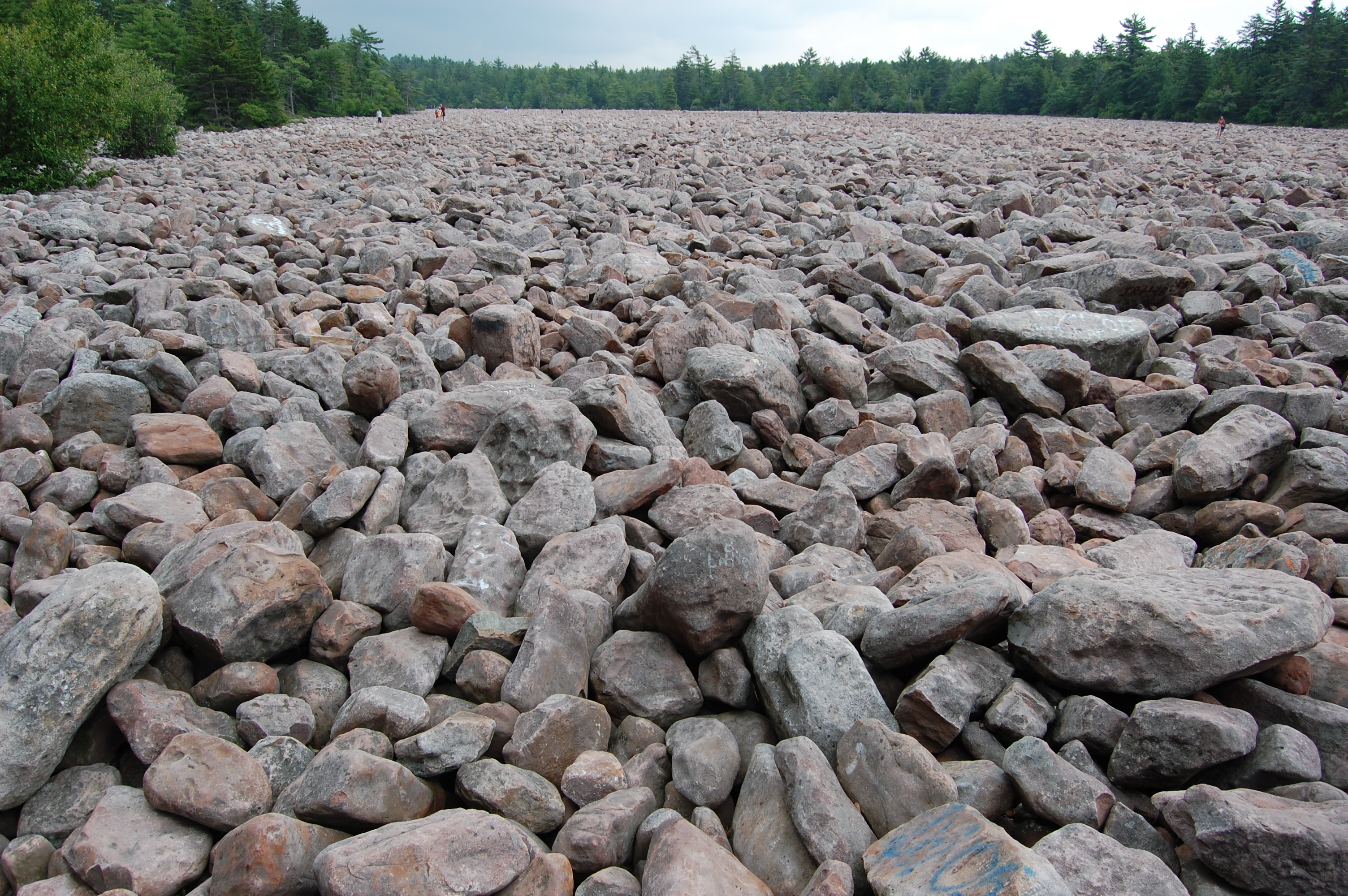
image_caption = Boulder Field at Hickory Run State Park, with people in the distance for scale
etymology_type = Named for
etymology = Hickory Run
country = United States
state = Pennsylvania
region_type = County
region = Carbon
district_type = Townships
district = Kidder
district1 = Penn Forest
city =
city1 =
location =
lat_d = 41
lat_m = 02
lat_s = 10
lat_NS = N
long_d = 75
long_m = 41
long_s = 02
long_EW = W
location_note = cite web
url=Gnis3|1192610
title=Hickory Run State Park
date =August 2 1979
work=Geographic Names Information System
publisher=United States Geological Survey
accessdate=2008-03-08]
elevation_imperial = 1647
elevation_round = 1
elevation_note =
area_unit = acre
area_imperial = 15550
area_round = 1
area1_imperial =
area1_type =
length_imperial =
length_orientation =
width_imperial =
width_orientation =
highest =
highest location =
highest_lat_d =
highest_lat_m =
highest_lat_s =
highest_lat_NS =
highest_long_d =
highest_long_m =
highest_long_s =
highest_long_EW =
highest_elevation_imperial =
lowest =
lowest_location =
lowest_lat_d =
lowest_lat_m =
lowest_lat_s =
lowest_lat_NS =
lowest_long_d =
lowest_long_m =
lowest_long_s =
lowest_long_EW =
lowest_elevation_imperial =
biome =
biome_share =
biome1 =
biome1_share =
geology =
geology1 =
plant =
plant1 =
animal =
animal1 =
established_type =
established = 1945
established1_type =
established1 =
management_body = Pennsylvania Department of Conservation and Natural Resources
management_location =
management_lat_d =
management_lat_m =
management_lat_s =
management_lat_NS =
management_long_d =
management_long_m =
management_long_s =
management_long_EW =
management_elevation =
visitation =
visitation_year =
free_type = Nearest city
free =Hazleton, Pennsylvania
free1_type =
free1 =

map_caption = Location of Hickory Run State Park in Pennsylvania
map_locator = Pennsylvania
website = [http://www.dcnr.state.pa.us/stateparks/parks/hickoryrun.aspx Hickory Run State Park]Hickory Run State Park is a convert|15500|acre|km2|2|adj=on Pennsylvania State Park in Kidder and Penn Forest Townships in Carbon County,
Pennsylvania in the United States. The park is spread across thePocono Mountains of NortheasternPennsylvania . The park is easily accessible fromInterstate 476 and Interstate 80.Hickory Run State Park is one of twenty-one chosen by the Pennsylvania Bureau of Parks for its "Twenty Must-See Pennsylvania State Parks" list. [cite web| url = http://www.dcnr.state.pa.us/stateparks/twenty/20parks.aspx | title = Twenty Must-See Pennsylvania State Parks | accessdate = 2007-08-08| publisher = Pennsylvania Department of Conservation and Natural Resources "Note: Despite the title, there are twenty-one parks in the list, with Colton Point and
Leonard Harrison State Park s treated as one."]Recreation
The park supports many activities, some of which vary seasonally. During the summer months,
swimming is available inSand Spring Lake , which is partially bordered by a sand beach. Beginning in 2008 lifeguards will not be posted at the beach. [cite web | url = http://www.timesleader.com/news/ap?articleID=384046 | title = Pa. state parks going without life guards at beaches in 2008 | accessdate = 2008-02-16 | publisher =The Times Leader ] In winter, the frozen lake can be used for ice skating. Seasonalhunting is permitted in many areas of the park, withwhite-tailed deer , black bear, andsquirrel s among the game that may be hunted legally. Additional hunting opportunities are available in nearby state game lands, some of which directly border the park.cite web
url = http://www.dcnr.state.pa.us/stateparks/parks/hickoryrun.aspx
title = Hickory Run State Park
accessdate = 2007-03-26
publisher = Pennsylvania Department of Conservation and Natural Resources]Geology
The most notable feature of Hickory Run State Park is the huge boulder field located in the northeast corner of the park. The boulder field can be reached by car on Boulder Field Road or by hiking the convert|3.5|mi|km|sing=on long Boulder Field Trail from the trailhead on SR 534. The field comprises about convert|720000|sqft|m2 or 16.5 acres, which is convert|0.026|sqmi|km2|1| in area (convert|1800|ft|1 east-west by convert|400|ft|1 north-south). The top of the boulder layer is virtually level with the approaching path. The immense weight of the boulders has compressed the underlying soil (convert|12|ft|0 or more. The boulder field was created about 20,000 years ago during the most recent glacial period. The boulders consist of the
sandstone and conglomerates identical to those capping the ridges that surround the field on three sides (theMississippian Pocono Formation ). Large amounts of melting waters from the glaciers apparently carried the boulders down from the ridges and into the valley where they now reside. The Boulder Field is truly a stunning sight, seemingly appearing out of nowhere in the park's dense woodland. Many visitors cannot resist hopping from boulder to boulder across the field. This unique geological landscape is aNational Natural Landmark .Hiking
The park contains more than convert|40|mi|km|0 of trails that offer a variety of
hiking experiences. For example, the convert|1.5|mi|1|adj=on long “Shades of Death” Trail follows the course of Sand Spring Run through dense rhododendron bushes that bloom from mid-June through mid-July. The run is dammed at certain points, creating scenic lakes. The Fireline, Gould and Pine Hill Trails are suitable for cross-country skiing in winter. A short convert|0.7|mi|1|adj=on walk on the Hawk Falls trail leads to a popular waterfall.Nearby state parks
The following state parks are within convert|30|mi|0 of Hickory Run State Park: [cite map |scale = 1:65,000| publisher= Pennsylvania Department of Transportation, Bureau of Planning and Research, Geographic Information Division | url= ftp://ftp.dot.state.pa.us/public/pdf/BPR_pdf_files/Maps/GHS/Roadnames/carbon_GHSN.pdf| title= 2007 General Highway Map Carbon County Pennsylvania | accessdate= 2007-07-27 "Note: shows Hickory Run State Park"] cite web
last = Michels
first = Chris
year = 1997
url = http://www2.nau.edu/~cvm/latlongdist.html
title = Latitude/Longitude Distance Calculation
publisher =Northern Arizona University
accessdate = 2008-04-20]
*Beltzville State Park (Carbon County)
*Big Pocono State Park (Monroe County)
*Frances Slocum State Park (Luzerne County)
*Gouldsboro State Park (Monroe and Wayne Counties)
*Jacobsburg Environmental Education Center (Northampton County)
*Lehigh Gorge State Park (Carbon and Luzerne Counties)
*Locust Lake State Park (Schuylkill County)
*Nescopeck State Park (Luzerne County)
*Tobyhanna State Park (Monroe and Wayne Counties)
*Tuscarora State Park (Schuylkill County)ources
Van Diver, B.B. (1990). "Roadside Geology of Pennsylvania". Missoula: Mountain Press Publishing Company.
References
External links
*
Wikimedia Foundation. 2010.