- U.S. Route 6 in Pennsylvania
-
This article is about the section of U.S. Route 6 in Pennsylvania. For the entire length of the highway, see U.S. Route 6.
- Pennsylvania Route 6 redirects here. For the short-lived Pennsylvania Traffic Route, now U.S. Route 219, see Pennsylvania Route 6 (1920s).
- "PA 6" and "PA 7" redirect here. For the congressional districts, see Pennsylvania's 6th congressional district and Pennsylvania's 7th congressional district.
U.S. Route 6
GAR Highway; Roosevelt Highway 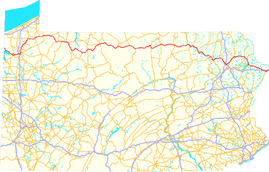
Route information Maintained by PennDOT Length: 394 mi[citation needed] (634 km) Existed: 1926 (1924 as PA 7) – present Major junctions West end:  US 6 near North Richmond, OH
 I-79 near Meadville
 US 15 in Mansfield
 I-81 near Scranton
East end:  US 6 / US 209 in Port Jervis, NY
Highway system United States Numbered Highways
List • Bannered • Divided • ReplacedRoads in Pennsylvania
Interstate • US • State • Legislative←  PA 5
PA 5PA 6  →
→←  US 6N
US 6N
PA 8  →
→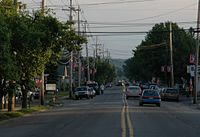 US Route 6 in Matamoras, Pennsylvania
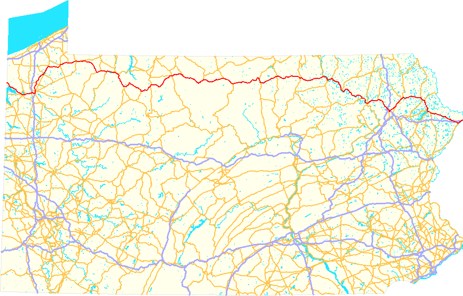
U.S. Route 6 travels east–west near the north edge of the U.S. state of Pennsylvania from the Ohio state line near Pymatuning Reservoir east to the Mid-Delaware Bridge over the Delaware River into Port Jervis, New York. It is the longest highway segment in the Commonwealth. Most of it is a two-lane rural highway, with some freeway bypasses around larger towns. Except east of Scranton, where it is paralleled by Interstate 84, it is the main route in its corridor. What is now Interstate 80—the Keystone Shortway—was once planned along the US 6 corridor as a western extension of I-84.[1] The corridor was originally the Roosevelt Highway from Erie, Pennsylvania to Port Jervis, New York, designated Pennsylvania Route 7 in 1924.[2] The PA 7 designation soon disappeared, but as US 6 was extended and relocated, the Roosevelt Highway followed it. The Pennsylvania section of US 6 was renamed the Grand Army of the Republic Highway in 1946; this name was applied to its full transcontinental length by 1953.[3]
US 6 meets with U.S. Route 19 near Meadville, where it turns north with US 19 to a point east of Edinboro. There it turns east (while U.S. Route 6N heads west to U.S. Route 20 at West Springfield) and passes through the Northern Tier of Pennsylvania. At Towanda it turns more southeasterly to reach Scranton, then turning back northeast out of Scranton to Carbondale and generally east and southeast to New York.
Contents
History
As approved by the American Association of State Highway Officials (AASHO) on November 11, 1926, the west end of US 6 was at Kane, where U.S. Route 120 continued west to Erie. (US 6 ended concurrent with U.S. Route 219, which ran east to Mt. Jewett along US 6 before turning north to New York.) US 6 also used present Pennsylvania Route 706, U.S. Route 11 and Pennsylvania Route 106 between Wyalusing and Carbondale, while U.S. Route 106 took the southerly route via Scranton.[4][5]
By the end of 1927, US 6 had replaced US 120 in running west from Kane to Erie (making US 120 no longer connect to its "parent" U.S. Route 20), and had swapped places with US 106 via Scranton; this took it along the Jefferson Highway. It was defined by AASHO to serve the following places in Pennsylvania: Erie, Waterford, Corry, Warren, Kane, Farmers Valley, Coudersport, Wellsboro, Canoe Camp, Mansfield, Towanda, Wyalusing, Tunkhannock, Clarks Summit, Scranton, Carbondale, Honesdale, Milford, and Matamoras.[6] By 1930 its west end was at 26th Street (U.S. Route 20) and State Street (US 6 - now Pennsylvania Route 505) in Erie. (By then U.S. Route 19 ended a block to the west on Peach Street, where it still ends today.)[7]
This original routing deviates majorly from present US 6 in the following places, roughly using the following current routes:[5]
- Pennsylvania Route 505 and Pennsylvania Route 97, Erie to Union City
- Pennsylvania Route 46, Pennsylvania Route 446 and Pennsylvania Route 155, Smethport to Port Allegany
- Pennsylvania Route 660 and U.S. Route 15 Business west of Mansfield
- Pennsylvania Route 92 and Pennsylvania Route 307, Tunkhannock to Clarks Summit
In 1931,[3] US 6 was extended west to Greeley, Colorado. It left its old route - which then became U.S. Route 6N - at Waterford, and headed south on former Pennsylvania Route 5 and U.S. Route 19 and west on U.S. Route 322 and former Pennsylvania Route 77 into Ohio. This whole section from Waterford to Cleveland, Ohio was regarded as temporary, but the only change was a relocation by 1936 along Pennsylvania Route 79 from Union City west to US 19 south of Waterford. (Former US 6 from Mount Union to Waterford became Pennsylvania Route 97. At the same time, US 6N was moved to the rest of former PA 79 from US 19 west to U.S. Route 20 - its current route.)[8]
Since then, only minor realignments and bypasses have been made to the route of US 6.
Major intersections
County Location Mile Destinations Notes Crawford Ohio state line 0.0 US 6 westContinues into Ohio Sadsbury Township 13.4  PA 618
Southern terminus of PA 618 Conneaut Lake 13.9  PA 285 west
Western end of concurrency with PA 285 14.3 
 US 322 west / PA 18 south (4th Street)
Western end of concurrencies with US 322 and PA 18 14.4 PA 285 east (3rd Street)Eastern end of concurrency with PA 285 Sadsbury Township 15.3 PA 18 northEastern end of concurrency with PA 18 Vernon Township 19.9 
 US 19 south / PA 98 (Perry Highway)
Southern end of concurrency with US 19,
southern terminus of PA 9821.0 I-79I-79 exit 147 21.8  PA 102 (Pennsylvania Avenue)
Southern terminus of PA 102 Meadville 22.8 US 322 east (Linden Street)Eastern end of concurrency with US 322 Saegertown 29.3  PA 198 east (State Street)
Southern end of concurrency with PA 198 30.0 PA 198 westNorthern end of concurrency with PA 198 Cambridge Springs 38.1 
 PA 86 / PA 408 (Main Street)
Northern and Western termini of PA 86/408 respectively 38.2  PA 99 (McClellan Street)
Southern terminus of PA 99 Erie LeBoeuf Township 44.2 US 6N / US 19 northNorthern end of concurrency with US 19,
eastern terminus of US 6NUnion City 52.9 PA 8 south (Main Street)Southern end of concurrency with PA 8 53.5 PA 8 north (Main Street)Northern end of concurrency with PA 8 Elgin 59.2  PA 89 north
Western end of concurrency with PA 89 Wayne Township 60.8 PA 89 southEastern end of concurrency with PA 89 Corry 64.8  PA 426 (Center Street)
Warren Columbus 67.6  PA 957 (Pike Road)
Western terminus of PA 957 Freehold 77.0  PA 958
Southern terminus of PA 958 Pittsfield 82.6  PA 27 west
Western end of concurrency with PA 27 Youngsville 85.3 PA 27 east (Main Street)Eastern end of concurrency with PA 27 Brokenstraw Township 89.1  US 62 south
Western end of concurrency with US 62, interchange Warren 94.0 

US 6 Bus. / US 62 north (Pennsylvania Avenue)Western terminus of US 6 BUS,
eastern end of concurrency with US 62, interchangeMead Township 96.9
US 6 Bus. (Pennsylvania Avenue)Eastern terminus of US 6 BUS 97.1  PA 59 (Kinzua Road)
Western terminus of PA 59 Sheffield 107.1  PA 666
Eastern terminus of PA 666 McKean Kane 122.6  PA 66 (Fraley Street)
Northern terminus of PA 66 123.1  PA 321 north (Hacker Street)
Western end of concurrency with PA 321 123.2 PA 321 southEastern end of concurrency with PA 321 Lantz Corners 130.6  US 219 (Buffalo Pittsburgh Highway)
Marvindale 140.3  PA 146
Western terminus of PA 146 Smethport 147.9 PA 59 (Main Street)Eastern terminus of PA 59 148.9  PA 46 north
Western end of concurrency with PA 46 East Smethport 149.6 PA 46 southEastern end of concurrency with PA 46 Port Allegany 157.3  PA 155 north (Main Street)
Northern end of concurrency with PA 155 158.5 PA 155 southSouthern end of concurrency with PA 155 Potter Coudersport 174.7  PA 44 north (Main Street)
Western end of concurrency with PA 44 176.7  PA 872
Northern terminus of PA 872 Sweden Valley 178.8 PA 44 south (Coudersport Jersey Shore Turnpike)Eastern end of concurrency with PA 44 Walton 189.3  PA 449 (Brooklyn Road)
Southern terminus of PA 449 Galeton 196.9  PA 144 (Bridge Street)
Northern terminus of PA 144 Tioga Gaines 201.5  PA 349 (Bridge Street)
Southern terminus of PA 349 Ansonia 208.9  PA 362
Western terminus of PA 362 Delmar Township 216.9  PA 287 north
Western end of concurrency with PA 287 Wellsboro 219.5  PA 287 south / PA 660 west (Main Street)
Eastern end of concurrency with PA 287,
western end of concurrency with PA 660Charleston Township 225.8 PA 660 eastEastern end of concurrency with PA 660 Mansfield 231.5 US 15Interchange 232.2
US 15 Bus. (Main Street)Richmond Township 234.0  PA 549
Southern terminus of PA 549 Bradford Troy 249.2  PA 14 south (Canton Street)
Western end of concurrency with PA 14 249.9 PA 14 northEastern end of concurrency with PA 14 North Towanda Township 266.7  US 220
Interchange Wysox 272.8  PA 187 (Rome Road)
Wyalusing Township 280.3  PA 409
Southern terminus of PA 409 Wyalusing 285.1  PA 706 (Church Street)
Western terminus of PA 706 Wyoming Braintrim Township 293.2  PA 367
Southern terminus of PA 367 Meshoppen 300.2  PA 267 (Auburn Street)
Southern terminus of PA 267 Washington Township 303.6  PA 87
PA 87Northern terminus of PA 87 Tunkhannock Township 307.8
US 6 Bus.Western terminus of US 6 BUS Tunkhannock 309.6  PA 29 (Bridge Street)
Tunkhannock Township 310.2  PA 92 south (Roosevelt Highway)
Western end of concurrency with PA 92 310.4
US 6 Bus.Eastern terminus of US 6 BUS 312.7 PA 92 northEastern end of concurrency with PA 92 Clinton Township 318.7  US 11 north (Lackawanna Trail)
Northern end of concurrency with US 11 Factoryville 319.3  PA 107
Western terminus of PA 107 Lackawanna LaPlume 321.3  PA 438 (La Plume Road)
Western terminus of PA 438 Dalton 323.1  PA 632 (Main Street)
Western terminus of PA 632, interchange South Abington Township 328.0  PA 407 (Grove Street)
328.2 
 I-476 / Penna. Tpk.
Northern terminus of I-476 US 11 (Scranton Expressway)Eastern end of concurrency with US 11 Scranton
I-81 / US 6 Bus.Interchange, Western end of concurrency with I-81, I-81 exit 194, Western terminus of US 6 BUS Dunmore 334.0  PA 347 (Blakely Street)
I-81 exit 188 335.6 
 I-81 south / I-84 / I-380
Southern end of concurrency with I-81, I-81 exit 187;
Western terminus of I-84 and the northern terminus of I-380, Exit 1 (Interstates 84 & 380)Throop Marshwood Road Exit 1 Olyphant East Lackawanna Avenue Exit 2 Jessup 340.2  PA 247 (Moosic Lake Road)
Exit 3 Archbald Salem Road Exit 4 Mayfield 345.6 PA 107 (Rushbrook Street)Eastern terminus of PA 107, Exit 5 Carbondale Township Meredith Street Exit 6 350.6
US 6 Bus.Eastern terminus of US 6 BUS, Exit 7 Wayne Waymart 354.3  PA 296
Prompton 358.5  PA 170
Southern terminus of PA 170 Honesdale 362.8  PA 191 north (Main Street)
Northern end of concurrency with PA 191 363.4 PA 191 south (Sunrise Avenue)Southern end of concurrency with PA 191 Indian Orchard 366.2  PA 652
Western terminus of PA 652 Hawley 371.6  PA 590 north (Hudson Street)
Northern end of concurrency with PA 590 Wilsonville 373.5 PA 590 southSouthern end of concurrency with PA 590 Pike Palmyra Township 374.9  PA 507
Northern terminus of PA 507 377.4  PA 402
Northern terminus of PA 402 Blooming Grove Township 380.9  PA 739 (Valley Road)
Northern terminus of PA 739 384.7  PA 434 east (Well Road)
Western end of concurrency with PA 434 384.7 PA 434 west (Shohola Road)Eastern end of concurrency with PA 434 Milford Township 395.5 I-84Interchange, I-84 exit 46 Milford 397.7 US 209 south (Harford Street)Western end of concurrency with US 209 Westfall Township 402.9 I-84Interchange, I-84 exit 53 New York state line US 6 east / US 209Continues into New York 1.000 mi = 1.609 km; 1.000 km = 0.621 mi
Concurrency terminus • Closed/Former • Incomplete access • UnopenedReferences
- ^ Official Route Numbering for the National System of Interstate and Defense Highways, August 14, 1957
- Note: the corridor had already been shifted south by September 1955, but the numbering was done on a map from August 2, 1947.
- ^ U.S. 22 - The William Penn Highway
- ^ a b Richard F. Weingroff, U.S. 6 - The Grand Army of the Republic Highway
- ^ United States System of Highways, November 11, 1926
- ^ a b 1927 map of Pennsylvania
- ^ United States Numbered Highways, 1927
- ^ 1930 map of Pennsylvania, back sidePDF (5.75 MiB)
- ^ Ohio Transportation Maps
External links
U.S. Route 6Previous state:
OhioPennsylvania Next state:
New YorkRoads of the Wyoming Valley Interstate Highways Expressways U.S. Routes US 6, US 11Pennsylvania Routes Highway transportation of Pike County, Pennsylvania Interstate Highways U.S. Highways U.S. Route 6- U.S. Route 206- U.S. Route 209
State Routes State Route 191- State Route 390- State Route 402- State Route 434- State Route 447- State Route 507- State Route 590- State Route 739- State Route 963-
Quadrant Routes QR 2001 (PA 962)
Categories:- U.S. Highways in Pennsylvania
- U.S. Route 6

Wikimedia Foundation. 2010.