- Pennsylvania Route 739
-
PA Route 739
Bethany Road
Dingman's Pike
Glen Eyre Road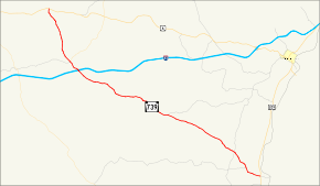
Route information Maintained by PennDOT Length: 19.36 mi[2] (31 km) Existed: 1967[1] – present Major junctions South end:  US 209 in Delaware Township
 I-84 near Lords Valley
North end:  US 6 in Blooming Grove
Location Counties: Pike Highway system Roads in Pennsylvania
Interstate • US • State • Legislative←  PA 737
PA 741  →
→Pennsylvania Route 739 is a Pennsylvania highway contained entirely within Pike County, Pennsylvania. It was signed in 1967, and runs for almost 19 miles (31 km).[1][3] Its northern terminus is at U.S. Route 6 in Blooming Grove, running south to U.S. Route 209 in Delaware Township. (There is some confusion regarding the official southern terminus of the highway.) PA 739's southern end marker was previously at the Dingman's Ferry Bridge, formally ending at the New Jersey state line over the Delaware River at Layton, New Jersey at County Route 560. It was moved back approximately .7 miles to the present location. This area south of Route 209 is now used by Quadrant Route 2019.
Traveling northward from the southern terminus, the highway passes through the Delaware Water Gap National Recreation Area. The highway also contains the Route 739 Business District. Route 739 runs under the names Dingman's Pike, Glen Eyre Road and Bethany Road.[4][5]
Contents
Route description
PA 2019
State Route 2019 begins at the Dingman's Ferry Bridge, where Sussex County Route 560 ends. The first sign that appears is for PA Route 739, which is an error, as PA 739 doesn't start for another 0.7 miles (1.1 km). The road starts by paying a toll for a bridge, which is manned by hand. PA 2019 goes through dense forests and passes its only intersection at half of a mile. PA 2019 ends at a traffic light with PA 739 and U.S. Route 209 in Dingmans Ferry.
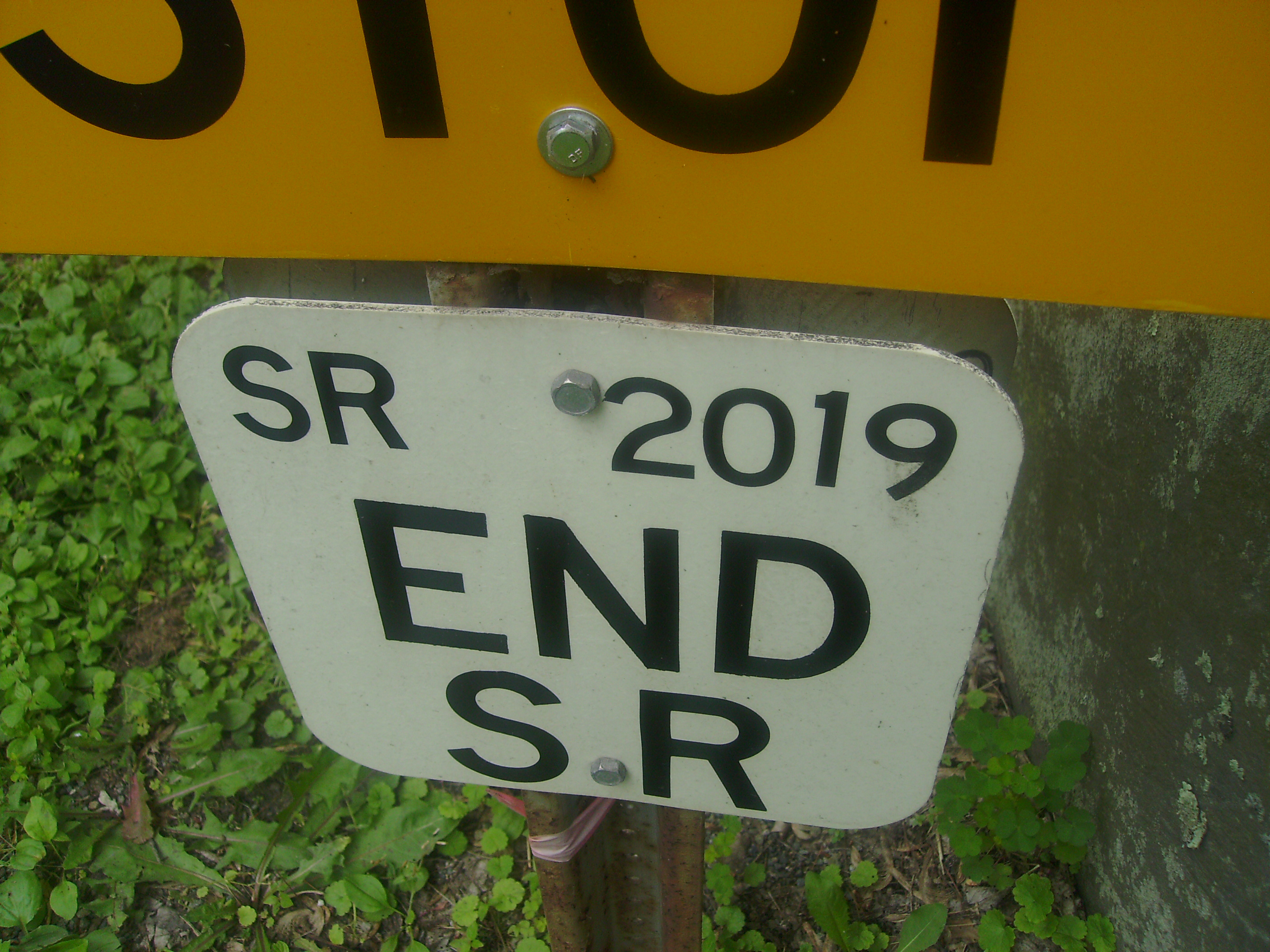
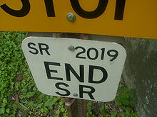 Signage for SR 2019's southern terminus
The southern terminus of Route 739 is unclear. A sign marking the end of the southbound route is in place near the junction with U.S. Route 209.[6] However, after entering Pennsylvania via the Dingman's Ferry Bridge, there is a marker in place immediately after the bridge signing the road as northbound 739. This leads to some confusion as to what the piece of road in the southbound lane in between US 209 and the state line at New Jersey's Sussex County Route 560 is. It is signed as Quadrant Route 2019, though most likely only for official PennDOT purposes.[6]
PA 739
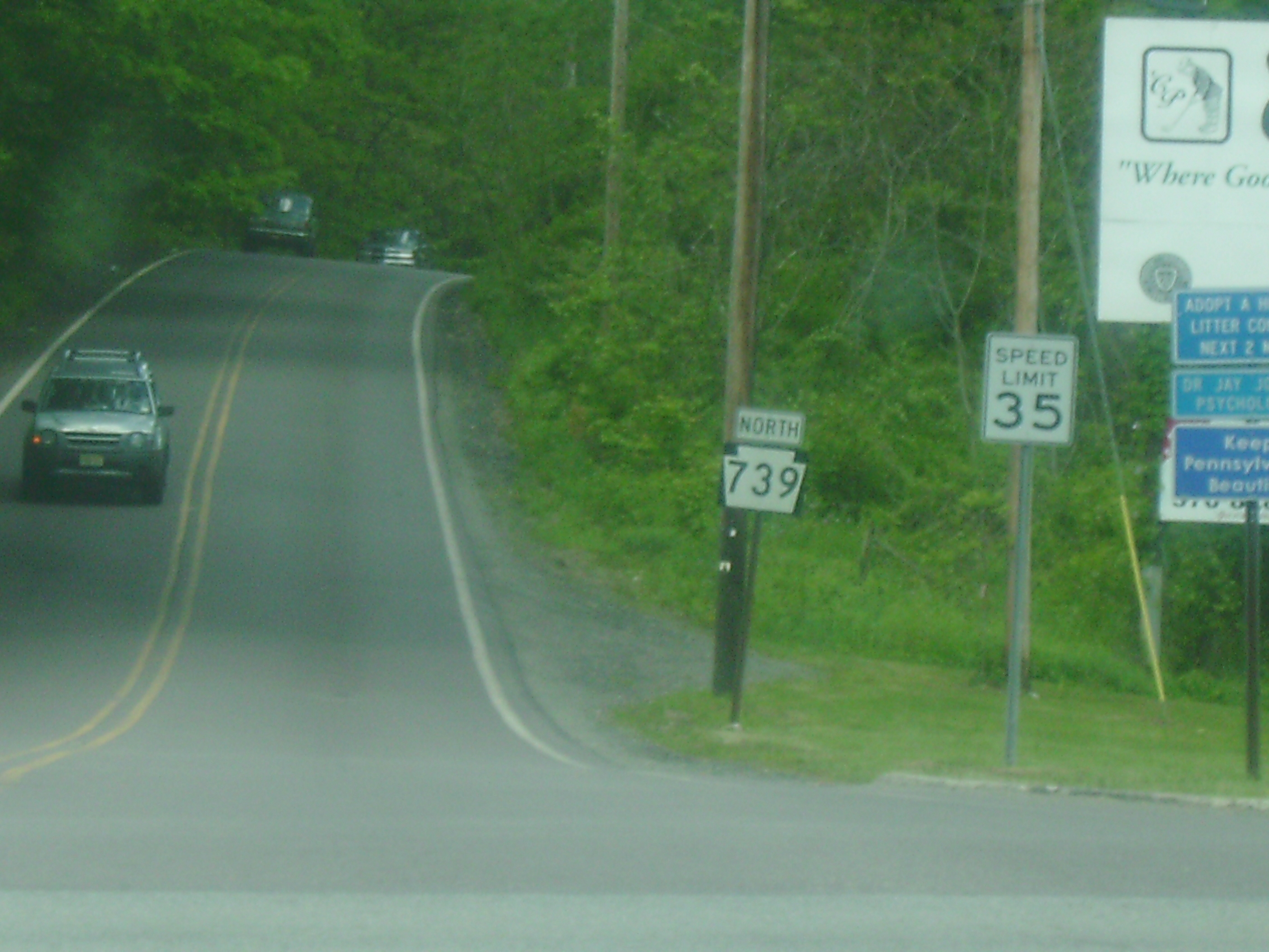
 PA 739 looking north from the southern terminus
PA Route 739 begins at a traffic light with U.S. Route 209 in Dingmans Ferry.The road starts going north through dense forests. After about 1-mile (1.6 km), Silver Lake Road (SR 2004), leaves to the left. Soon after the intersection with Sproul Road, PA 739 leaves the Delaware Water Gap National Recreation Area.[7] At milepost 2.45, 739 crosses a traffic light with Quadrant Route 2001, also known as Milford Road.[3] The road continues through the dense forest and passes three of five Dingman Township schools. At 7.40 miles (11.91 km), PA 739 meets up with Quadrant Route 2006 (Log Tavern Road).[3] PA 739 leaves Dingman Township and enters Blooming Grove Township.[7] Continuing north, PA 739 intersects with Interstate 84 at Exit 34 (formerly Exit 9) just south of Lords Valley. The road goes farther, crossing Quadrant Route 4004 and PA Route 434 at 14.26 miles (22.95 km). At this time, PA 739 changes names to Glen Eyre Road.[5] PA 739 ends at an intersection with U.S. Route 6 in Blooming Grove Township more than four miles (6 km) later.[6] Although the 739 ends at Route 6, the Glen Eyre Road designation continues on.[7]
History
 Quadrant Route 2019 (1993-present)
The road was designated Pennsylvania State Route 739 in 1967 and has kept the designation since then.[1] In 1978, the road just south of Interstate 84 to two miles (3 km) north of Dingmans Ferry was paved. From 1999 and before, the intersection with PA 434 used to be with PA 1001.[8] The road was changed to State Route 434 on the 2003 Pike County Maps.[9] The southern designation of PA 739, State Quadrant Route 2019, first appeared on the PennDOT's maps of Pike County in 1993.[10] That designation has existed ever since.
Construction
In 2003, the Pennsylvania Department of Transportation ordered excavation of the intersection of PA 739 and PA 2001 (Milford Road). The project was part of an $812,000 intersection improvement project, which was to be completed that summer.[11] During the week of September 21, 2001, the work of adding advanced warning signs to the PA 739/PA 2001 intersections were added.[12] During May 21 through May 25, 2007, lines were re-painted in Delaware Township.[13] From the week of September 15–22, 2001, Route 739 went through some drainage work.[14] In the year 2007, a program was started that would improve different roads around the state. There were three periods included. PA 739 was in the first period, due to finish in 2010. The project for 739 was highway restoration in curves and take about $300,000 to complete.[15]
Major intersections
PA 2019
The entire route is in Pike County.
Location Mile[2][3] Destinations Notes Delaware Township 0.00  CR 560 (Tuttles Corner Road)
Southern terminus of PA 2019. Dingmans Ferry Bridge 0.50 Johnny Bee Road 0.67  US 209 (Federal Highway) / PA 739 (Dingmans Turnpike)
Northern terminus of PA 2019. Right-of-way continues as Route 739. 1.000 mi = 1.609 km; 1.000 km = 0.621 mi PA 739
The entire route is in Pike County.
Location Mile[3] Destinations Notes Delaware Township 0.00 US 209 (Federal Highway) / SR 2019Southern terminus of PA 739. Lords Valley 14.19 I-84Exit 34 (I-84). Formerly Exit 9. 14.26  PA 434 / SR 4004
Southern terminus of PA 434. Blooming Grove Township 19.36 US 6 (Grand Army of the Republic Highway)Northern terminus of PA 739. 1.000 mi = 1.609 km; 1.000 km = 0.621 mi References
- ^ a b c Pennsylvania Highways - PA 739
- ^ a b Pennsylvania State Roads - 2010. Harrisburg, Pennsylvania: Pennsylvania Department of Tranpsortation. 2010.
- ^ a b c d e DeLorme Street Atlas USA 2007, Toggle Measure Tool
- ^ PENNDOT'S NORTHEASTERN PENNSYLVANIA ROADWORK SCHEDULE FOR NOVEMBER 16 - 23
- ^ a b Google, Inc. Google Maps – overview map of PA 739 by Google (Map). Cartography by Google, Inc. http://maps.google.com/maps?um=1&tab=wl&hl=en&q=PA-739. Retrieved June 8, 2009.
- ^ a b c Pennsylvania DOT Video log map
- ^ a b c PADOT - Pike County Map - 2004
- ^ PADOT - Type 10 Map of Pike County - 1999
- ^ PADOT - Type 10 Map of Pike County - 2003
- ^ PADOT - Type 10 Map of Pike County - 1993
- ^ DELAYS LIKELY DURING EXCAVATION WORK AT INTERSECTION OF PA ROUTE 739 AND STATE ROUTE 2001
- ^ PENNDOT'S NORTHEASTERN PENNSYLVANIA ROADWORK SCHEDULE FOR WEEK OF SEPTEMBER 21 - 29
- ^ Pike County - Construction - Times Tribune
- ^ PENNDOT'S NORTHEASTERN PENNSYLVANIA ROADWORK SCHEDULE FOR SEPTEMBER 15-22
- ^ Twelve Year Program Project Listing from PennDOT
External links
Categories:- State highways in Pennsylvania
- Transportation in Pike County, Pennsylvania


Wikimedia Foundation. 2010.