- Pennsylvania Route 402
-
PA Route 402
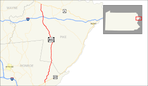
Route information Maintained by PennDOT Length: 29.31 mi[1] (47.17 km) Existed: 1928 – present Major junctions South end: 

 US 209/US 209 Business in Middle Smithfield Township
 I-84 in Blooming Grove Township
North end:  US 6 in Blooming Grove Township.
Location Counties: Monroe, Pike Highway system Roads in Pennsylvania
Interstate • US • State • Legislative←  PA 401
PA 403  →
→Pennsylvania Route 402 (designated by the Pennsylvania Department of Transportation as SR 0402) is a 29.31-mile (47.17 km) north–south state route in the Pennsylvania counties of Pike and Monroe. The southern terminus of the route is at U.S. Route 209 in the Smithfield Township village of Marshalls Creek. The northern terminus is at U.S. Route 6 in Blooming Grove Township. Route 402 has remained intact for most of its lifetime, with only one minor realignment after being assigned in 1928. Route 402 is also part of an on-hold project called the Marshalls Creek Bypass. The bypass was proposed in 1991 to relieve congestion on Route 402 in the village of Marshalls Creek.
Contents
Route description
Monroe County
Route 402 begins at an intersection with U.S. Route 209 in Smithifield Township. The southern terminus, located in the village of Marshalls Creek, is highly developed, with buildings surrounding the road for a short distance. The highway leaves downtown Marshalls Creek and enters a more suburban area. Route 402 turns northward, with its former road heading eastward. Pond Creek is the first landmark, passing just north of Marshalls Creek.[1]
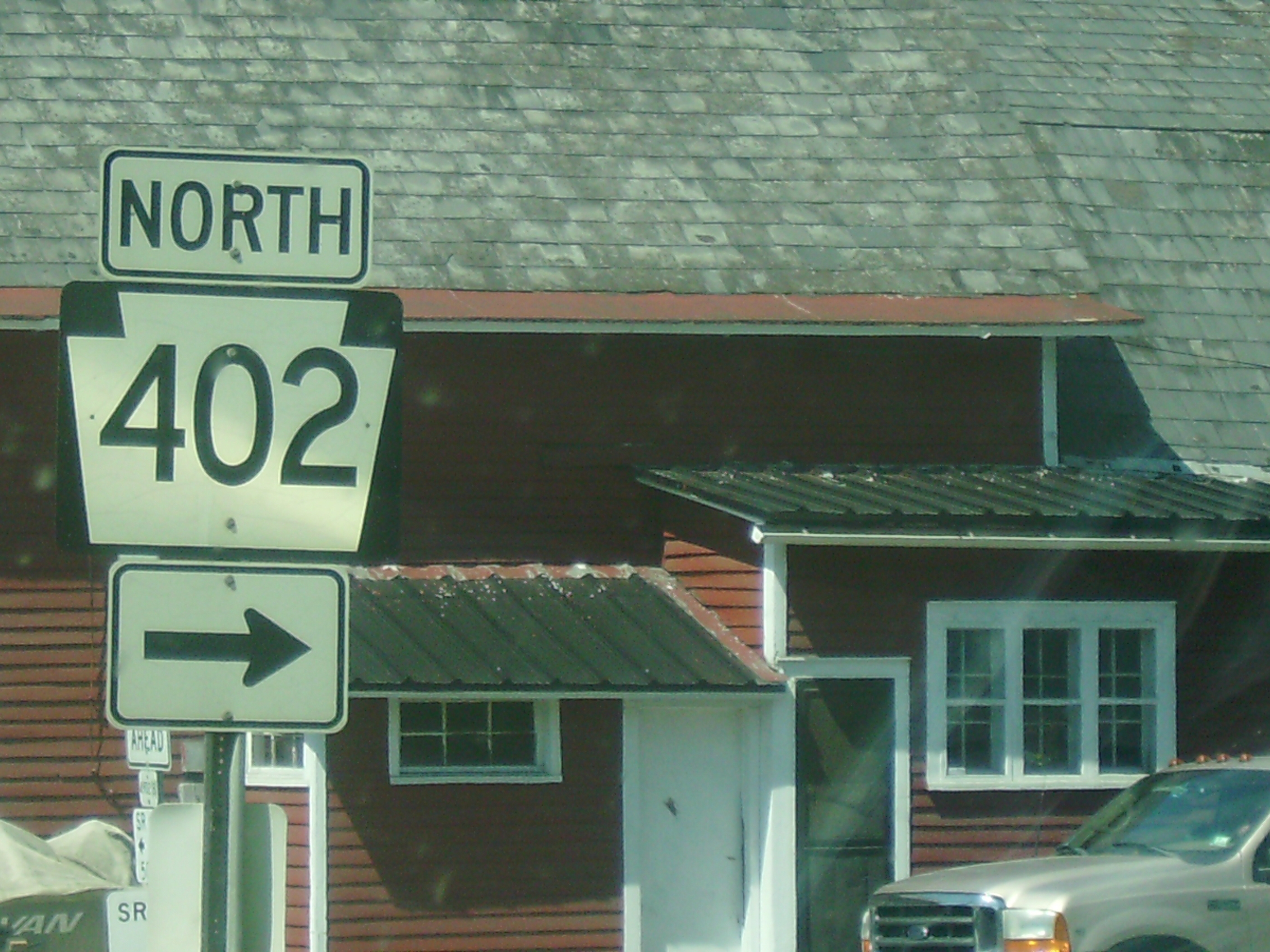
 PA 402 directional sign from U.S. 209 in Marshalls Creek
Route 402 heads north, passing through forests. The highway is at the point parallelling U.S. Route 209, which is just southeast of the road. White Heron Lake is close to the north, with the Pocono Mountains in the nearby area. Although the surroundings around Route 402 are still rural, nearby there are short roads that connect to local suburbs. The road, currently known as Resica Falls Road, passes through Poplar Bridge, where there are a park and several homes. In his popular 1960s novel "Stranger in a Strange Land", the late science-fiction author Robert A. Heinlein placed the fictional estate of character Jubal Harshaw in the rolling hills somewhere to the east of Route 402 probably between the Marshalls Creek and Resica Falls area.[1]
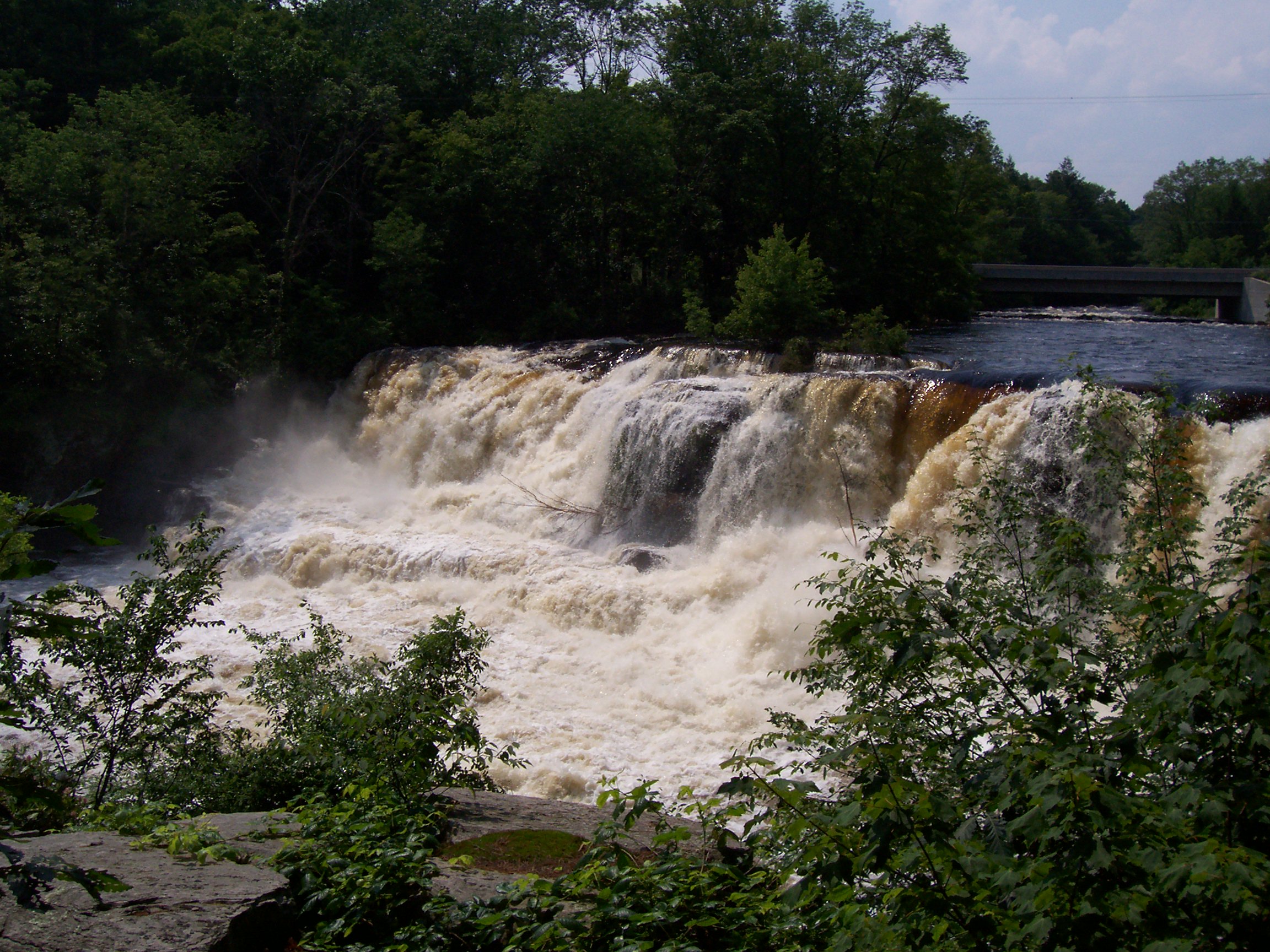
The Country Club of the Poconos is accessible from Route 402 as it heads northward out of Poplar Bridge. The highway becomes rural again, with trees surrounding the route for a distance. Route 402 crosses the Resica Falls, a waterfall on the Bush Kill. The road becomes rural again, leaving Monroe County for Pike County just after an intersection with Timothy Lake Road.[1]
 View from Route 402 as it crosses the Resica Falls
Pike County
The rest of PA 402 is in Pike County. Even after crossing the county line, Route 402 is mainly rural, with small breaks at intersections with local roads. 12 Mile Pond is visible to the east as the highway continues northward through the western parts of Pike County. Just after 12 Mile Pond, Route 402 passes Spruce Run Drive, a circle road that services local homes. The highway passes the Beaver Run Dump at a small highway intersection. Beaver Pond, a small pond in Pike County, is accessible just north of the dump off Beaver Run Road. North of Beaver Pond, Route 402 turns to the northeast, intersecting with Bushkill Falls Road (Pike County Quadrant Route 2003) soon after.[1]
The highway then passes Porters Lake, where it intersects with Silver Lake Road, a connector route from Route 402 to nearby PA 739. Silver Lake Road is also Quadrant Route 2004. Just north of Silver Lake Road, Pickerel Lake is accessible to the west. The highway is still rural, with trees continuously passing both sides. North of Pickerel Lake, Route 402 passes Pecks Pond and intersects with a former alignment of itself. The former alignment parallels Route 402 to the west and Pecks Pond to the east. After both roads intersect with 2 local roads, they merge together and Route 402 continues northward.[1]
Route 402 intersects with local roads north of Pecks Pond, heading now to the northwest. As the highway progresses, it enters Blooming Grove Township. Just after entering the township, Route 402 interchanges with Interstate 84 at Exit 30. Just north of I-84, the highway intersects Blooming Grove Road (Quadrant Route 4004). Continuing on its final stretch of highway, Route 402 heads northward, passing more forests, some homes and businesses as well.[1]
Just north of White Deer Lake, Route 402 heads northward, where it terminates at U.S. Route 6 soon after.[1]
History
Early history
Route 402 was assigned to most of its current routing in 1928, with the exception of a short segment at Pecks Pond, where it originally ran along the shoreline of the pond.[2] The route was realigned later onto its current routing.[1] The road was still under construction from 1931 to 1932, with the road being put together from Marshalls Creek to Snowhill Road. Route 402 was completed and paved in 1932.[2]
Route 402 originally ran farther south to PA 612 in East Stroudsburg. This original southern segment headed south of Marshalls Creek, passing Buttermilk Falls and terminating in the village of Minisink Hills.[3] This segment is now an alignment of U.S. Route 209, which once went into East Stroudsburg. The original 209 alignment is now US 209 Business.[4]
Marshalls Creek Bypass
In 1991, a bypass of the southern terminus of Route 402 was proposed by Monroe County, with approval by the Federal Highway Administration coming 10 years later.[5] This intersection was often congested, with local residents asking for a bypass of the highway. The project originally was going to cost $70 million in construction funds. This was true until Pyrite was found along the area where the bypass was to be constructed. Investigations into resolving problem ensued, with findings currently not released.[2]
Groundbreaking for the bypass began on August 24, 2005.[2] However, the first of three phases into completing the large project was to cost $14.2 million. $15 million was planned for the second phase, with $40 million coming for the final phase.[6] In April 2008, PennDOT put the construction on hold for the reason cited as skyrocketing construction prices. The 3.5 miles (5.6 km) bypass cost price had gone from $68 to over $200 million in funds.[7]
On April 17, 2008, local officials, along with state officials, met with officials of governor Edward Rendell, where a project redesign would be promised. A Monroe County official reportedly admitted that the Marshalls Creek Bypass is the only project on the endangered list, while PennDOT had originally said more were.[8]
Major intersections
County Location Mile[1] Destinations Notes Monroe Smithfield Township 0.00 US 209

US 209 BusinessHamlet of Marshalls Creek.
Northern terminus of US 209 Business.Pike Blooming Grove Township I-84Exit 30 (I-80). Formerly exit 8. 29.31 US 61.000 mi = 1.609 km; 1.000 km = 0.621 mi References
- ^ a b c d e f g h i j Yahoo! Inc. Yahoo! Maps – overview map of PA 402 (Map). Cartography by NAVTEQ. http://maps.yahoo.com/#mvt=m&lat=41.429197&lon=-75.135657&zoom=18&q1=41.042866%2C-75.127428&q2=41.429217%2C-75.137814. Retrieved 2008-05-26.
- ^ a b c d Kitsko, Jeff. "Pennsylvania Highways - Pennsylvania Route 402". http://www.pahighways.com/state/PA401-450.html#PA402. Retrieved 2008-06-26.
- ^ USGS (1943). Bushkill, PA quadrangle (Map). http://historical.maptech.com/getImage.cfm?fname=bshl43sw.jpg&state=PA. Retrieved 2008-05-27.
- ^ Pennsylvania Department of Transportation. 2007 PA State Map (Map). Cartography by PennDOT.
- ^ Brelje, Beth (April 9, 2008). "PennDOT stops work on Marshalls Creek Bypass". Pocono Record. http://www.poconorecord.com/apps/pbcs.dll/article?AID=/20080409/NEWS/804090313/-1/news0906. Retrieved 2008-05-26.
- ^ "Initial phase of bypass will cost $14.2 million". Pocono Record. May 21, 2005. http://www.poconorecord.com/apps/pbcs.dll/article?AID=/20050521/NEWS/80408031/-1/news0906. Retrieved 2008-05-26.
- ^ Pierce, David (April 8, 2008). "PennDOT slams brakes on Marshalls Creek Bypass". Pocono Record. http://www.poconorecord.com/apps/pbcs.dll/article?AID=/20080408/NEWS/80408020. Retrieved 2008-05-26.
- ^ "Bypass future remains wait-and-seeypass". Pocono Record. May 8, 2008. http://www.poconorecord.com/apps/pbcs.dll/article?AID=/20080508/NEWS/805080350. Retrieved 2008-05-26.
External links
Categories:- State highways in Pennsylvania
- Transportation in Monroe County, Pennsylvania
- Transportation in Pike County, Pennsylvania


Wikimedia Foundation. 2010.