- Pennsylvania Route 737
-
PA Route 737
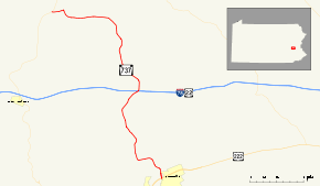
Route information Maintained by PennDOT Length: 10.58 mi[1] (17.03 km) Existed: 1962 – present Major junctions South end:  US 222 in Kutztown
 I-78 / US 22 in Greenwich Township
North end:  PA 143 in Albany Township
Location Counties: Berks Highway system Roads in Pennsylvania
Interstate • US • State • Legislative←  PA 732
PA 739  →
→Pennsylvania Route 737 (Route 737) is a state highway in Berks County, Pennsylvania. The route runs from U.S. Route 222 in Kutztown north to Pennsylvania Route 143 in Albany Township. Route 737 heads north from an interchange with the U.S. Route 222 Kutztown Bypass north of Kutztown on Krumsville Road. It continues north through a small part of Maxatawny Township into Greenwich Township. The road features an interchange with Interstate 78/U.S. Route 22 near the village of Krumsville. Route 737 then heads northwest into Albany Township where it ends Route 143 near the village of Kempton.
Route 737 was assigned to a formerly un-designated local road between Kutztown and Kempton in 1962. Around that time, U.S. Route 222 served as the southern terminus in downtown Kutztown. When the Kutztown Bypass was constructed in the 1970s, U.S. Route 222 was realigned off of Main Street in Kutztown and onto the bypass. The road, at that point, ended at the now locally-maintained Main Street until 1978, when the designation was truncated. Since then, the route has remained virtually untouched in alignment.
Contents
Route description
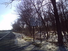
 Route 737 nearing the Kutztown Bypass (U.S. Route 222)
Route 737 begins at the southern point of the interchange with U.S. Route 222 north of the municipality of Kutztown. South of the interchange, the right-of-way continues as Greenwich Street into downtown Kutztown. From the interchange, Route 737 heads northward along the community borderline on Krumsville Road. The route heads northward through dense forestry and some small hills, quickly entering the community of Eagle Point. In Eagle Point, the road becomes slightly developed. After the highway intersects with Sweet Corn Drive, Route 737 leaves the community and begins its way to the northwest.[2]
Route 737 heads to the northwest, intersecting with Long Dam Road, which parallels through another set of deep forests. At a curve to the north, the highway intersects with Kutz Mill Road, the highway heads through a close area of fields and forests. At an intersection with Ebling Road, it begins curving its way through the area. After Wiltrout Road, the highway begins on a northward progression through Greenwich Township. After Sunrise Boulevard, Route 737 heads out of the developed area. Nearing an intersection with Sutter Road, Route 737 turns to the northeast and enters Krumsville.[2]
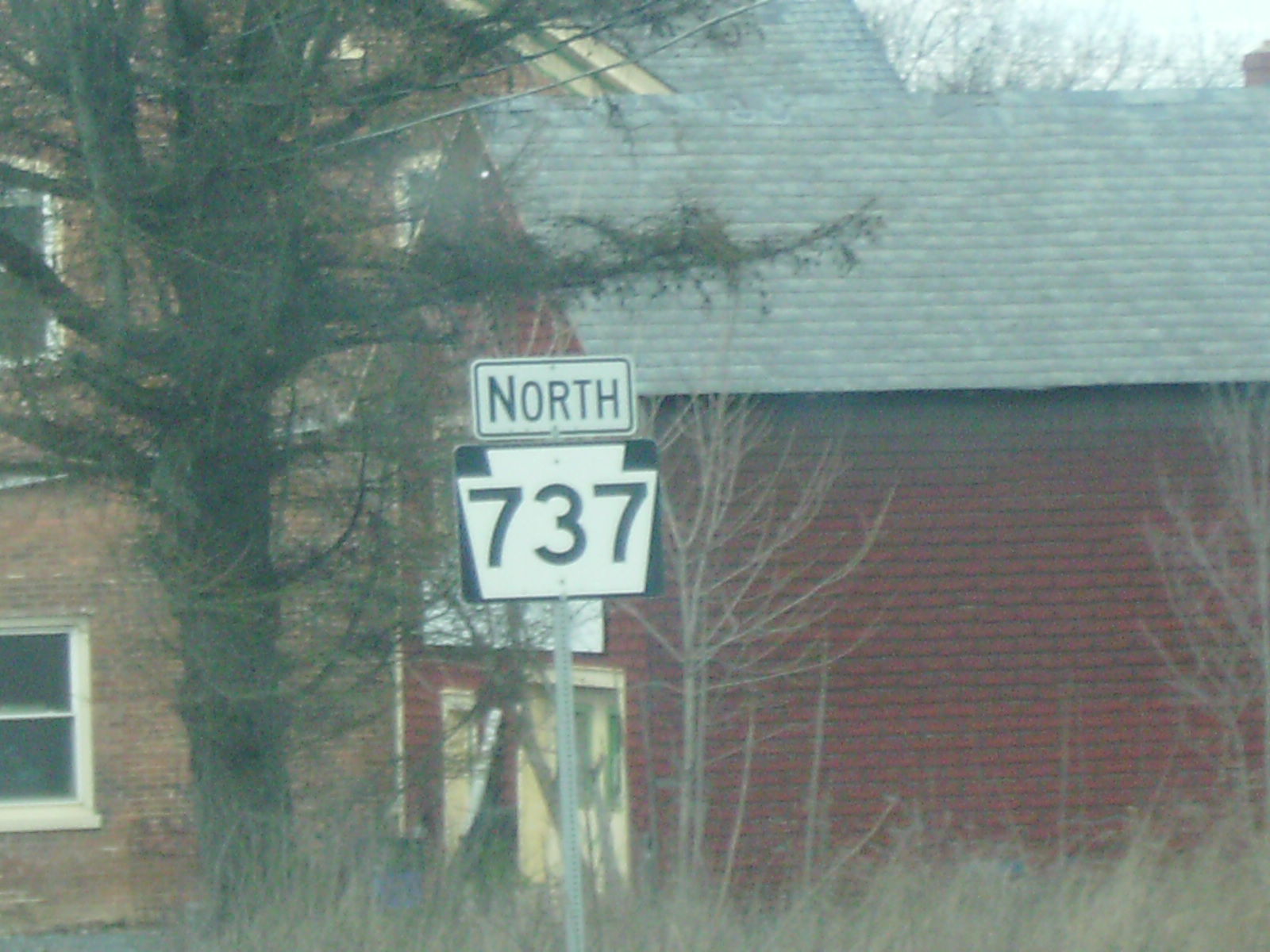
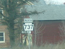 PA 737 heading northbound and into Krumsville
In Krumsville, the surroundings of the highway becomes more developed, passing local commercial businesses. There it interchanges with Interstate 78 and U.S. Route 22 at Exit 40. After the interchange, the highway heads northward into the rural regions of Krumsville, intersecting with the former alignment of U.S. Route 22.[3] At the intersection with Long Lane Road, Route 737 leaves Krumsville. There, the road becomes surrounded by fields, with several farmhouses in the area. After an intersection with Snyder Road, Route 737 begins to follow several bends in the highway, progressing its way towards Kempton. Eventually there is a curve to the northwest, and the highway enters the developed community of Stony Run. The highway enters and leaves, turning now in a westerly progression. Forests and fields surround the progressing highway from north and the south, as Route 737 makes its final turn and into Kempton, another developed area. After passing Albany Township Elementary School, the designation terminates at an intersection with Route 143 south of Trexler.[2]
History
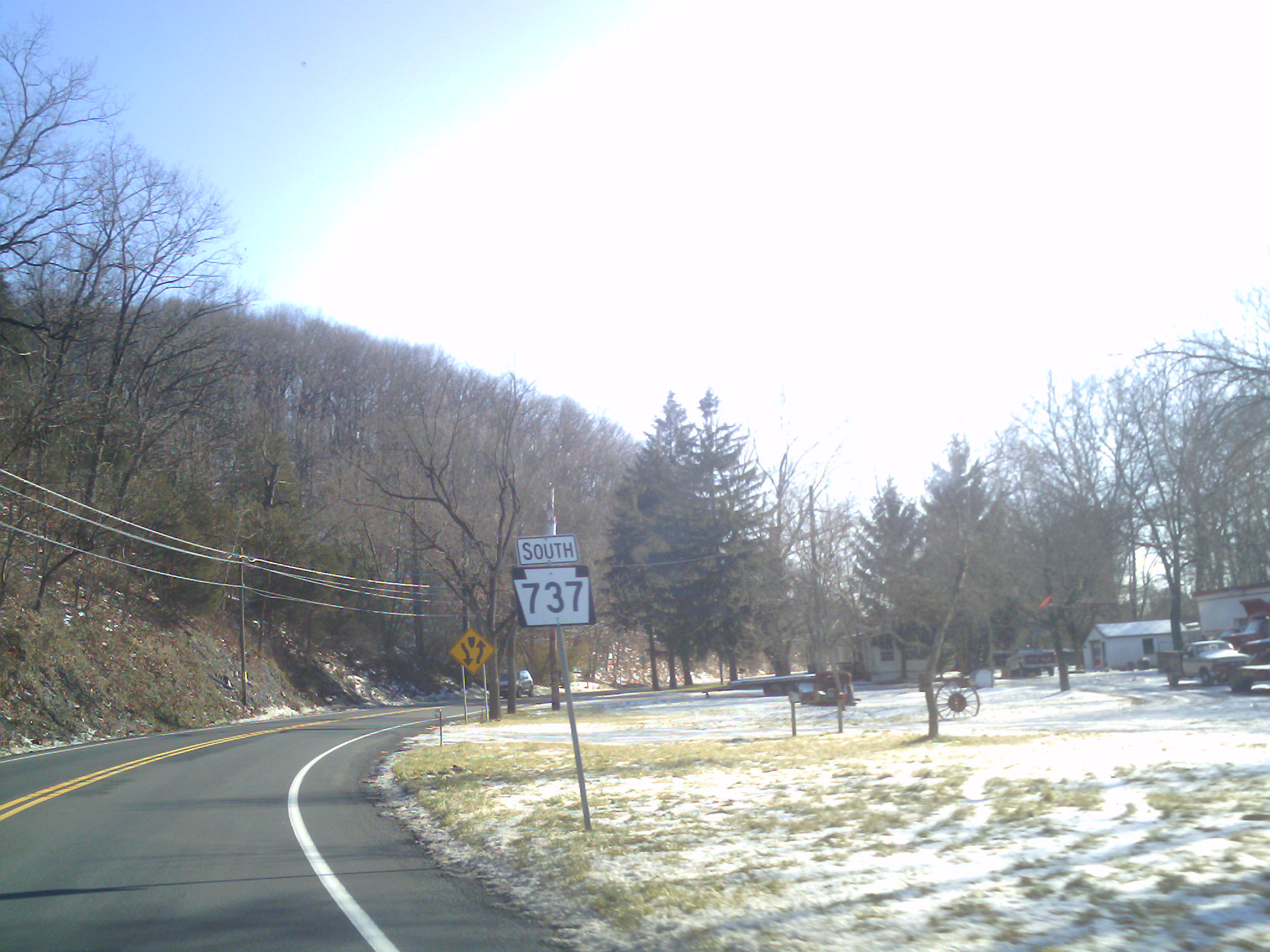
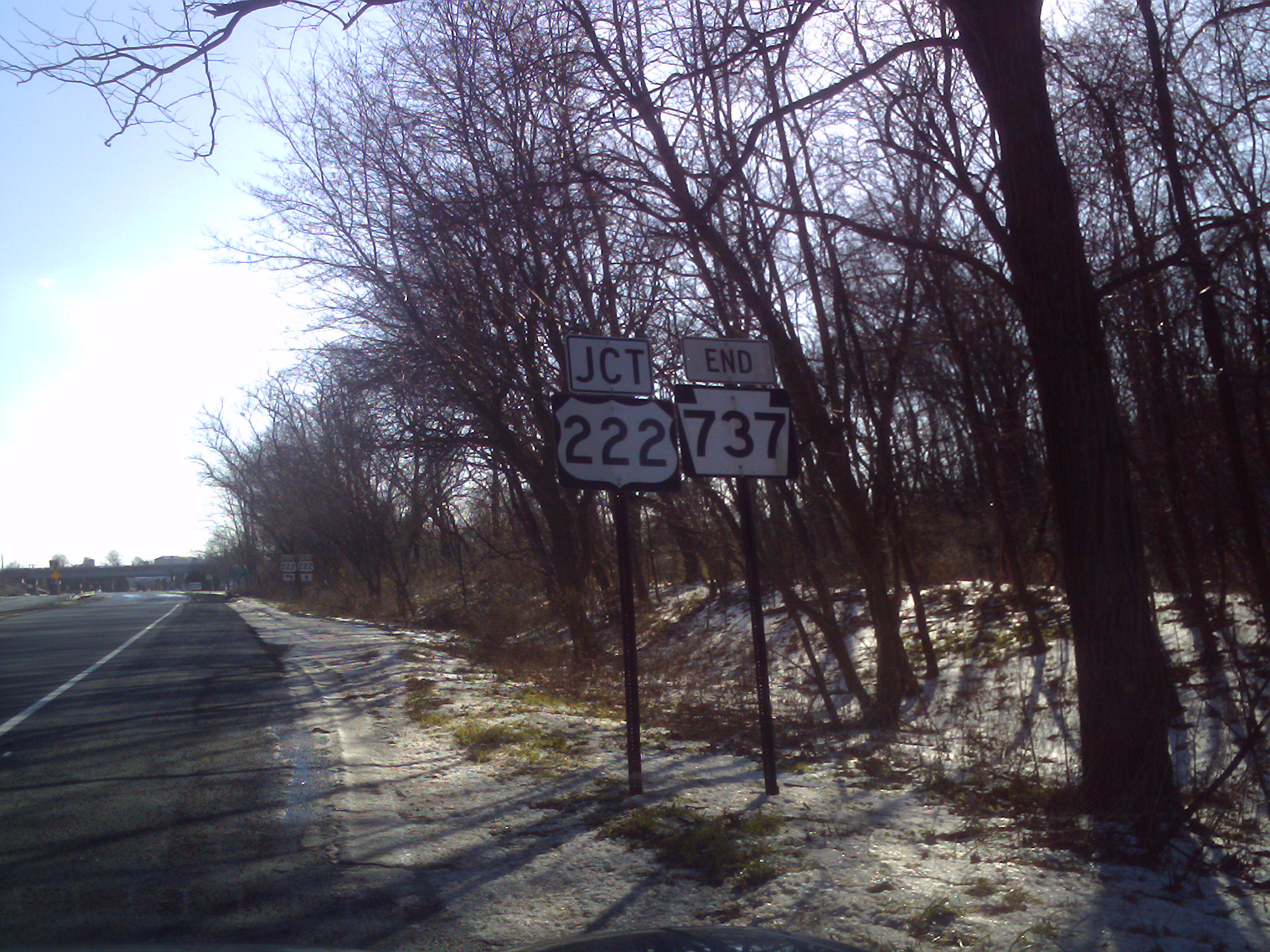
 PA 737 approaching its southern terminus. The sign designating the highway's end is visible to the center of the image
Route 737 originated as an unnumbered arterial highway from U.S. Route 222 in downtown Kutztown to Pennsylvania Route 143 at an intersection in Kempton.[4] The state took over the alignment in 1962, designating the highway as Route 737 on the alignment of the arterial highway.[5] In 1971, the newly-formed Pennsylvania Department of Transportation began construction on the Kutztown Bypass, an alignment of U.S. Route 222 that was planned to bypass downtown Kutztown. The bypass was constructed in September 1972 and U.S. Route 222 was realigned onto the new highway in 1973.[6] After the realignment, PA Route 737 now ended at unnumbered Main Street in downtown Kutztown for a short time.[7] By 1978, the southern terminus of PA 737 had been adjusted to the interchange with the Kutztown Bypass.[8] The route has remained virtually untouched since.[9] Route 737 and its interchange with Interstate 78 in Krumsville was reconstructed in 2006, with the interchange receiving additional truck lanes from I-78.[10] On July 23, 2009, the borough of Kutztown sold 5 acres (66,000 ft) of land to Maxatawny Township, Pennsylvania for future construction of a sewer plant.[11] In 2009, Berks County began to work on design for a new "Accelerated Bridge Program" for several bridges, one on Route 737 and two on nearby Quadrant Routes. The bridges are set to use stimulus money from the American Recovery and Reinvestment Act (ARRA), which will cost the county about $180,000 (2009 USD) for the studies.[12]
Major intersections
The entire route is in Berks County.
Location Mile[2][1] Destinations Notes Kutztown 0.00 US 222Kutztown Bypass interchange Krumsville I-78 / US 22Exit 40 (I-78/US 22). Old Route 22 Former alignment of US 22. Kempton 10.58 PA 1431.000 mi = 1.609 km; 1.000 km = 0.621 mi See also
- List of State Routes in Pennsylvania
- Pennsylvania Route 863 - a highway that follows a similar alignment to PA 737 to the east.
References
- ^ a b Pennsylvania State Roads - 2010. Harrisburg, Pennsylvania: Pennsylvania Department of Tranpsortation. 2010.
- ^ a b c d Yahoo! Inc. Yahoo! Maps – overview map of Pennsylvania Route 737 (Map). Cartography by NAVTEQ. http://maps.yahoo.com/#mvt=m&lat=40.526711&lon=-75.768449&zoom=14&q1=40.623522%2C-75.861919&q2=40.527298%2C-75.781924. Retrieved April 26, 2009.
- ^ Pennsylvania Department of Highways (1946). Pennsylvania Official Road Map (Map).
- ^ United States Geological Survey (1956). Hamburg, Pennsylvania 15-min quadrangle (Map). Cartography by United States Geological Survey. http://historical.mytopo.com/getImage.asp?fname=hamb56se.jpg&state=PA. Retrieved April 26, 2009.
- ^ Pennsylvania Department of Highways (1962). Pennsylvania Official Road Map (Map).
- ^ Research and Development, Offices of (2007). Report No. FHWA-RD. Federal Highway Administration.
- ^ Pennsylvania Department of Transportation (1974). Pennsylvania (Map). Cartography by Pennsylvania Department of Transportation.
- ^ Pennsylvania Department of Transportation (1978). Pennsylvania (Map). Cartography by Pennsylvania Department of Transportation.
- ^ Pennsylvania Department of Transportation (2009). Pennsylvania (Map). Cartography by Pennsylvania Department of Transportation.
- ^ "Pennsylvania’s 2007 Transportation Program". Pennsylvania Department of Transportation. 2007. http://google.com/search/cache?ei=UTF-8&p=Pennsylvania+Route+737+Berks+County&y=Search&xa=OOkH0t1VxEx7uJgX_UDchQ--%2C1249260954&fr=yfp-t-151&u=www.seda-cog.org/seda_cog/lib/seda_cog/trans/2007_twelve_year_program_narrative_and_listing.pdf&w=pennsylvania+pa+route+737+berks+county&d=Sz0fWxlMS2Vr&icp=1&.intl=us. Retrieved August 2, 2009.
- ^ DeLucas, Stephen F. (July 23, 2009). "Kutztown approves sale of land for sewer plant". Reading Eagle. http://www.readingeagle.com/article.aspx?id=149393. Retrieved August 2, 2009.
- ^ "Reading Area Transportation Study". Berks County, Pennsylvania. January 15, 2009. http://google.com/search/cache?ei=UTF-8&p=%22PA+737%22+November+2008+construction&y=Search&u=www.co.berks.pa.us/planning/lib/planning/rats/meetings_09/coordjan09minutes.pdf&w=%22pa+737%22+november+2008+construction&d=M3275xlMTD3m&icp=1&.intl=us. Retrieved August 2, 2009.
External links
- Kitsko, Jeffrey J. (2009). "PA 737". Pennsylvania Highways. pp. 701–750. http://www.pahighways.com/state/PA701-750.html#PA737.
Categories:- State highways in Pennsylvania
- Transportation in Berks County, Pennsylvania


Wikimedia Foundation. 2010.