- Interstate 78
Infobox road
route=78
type=I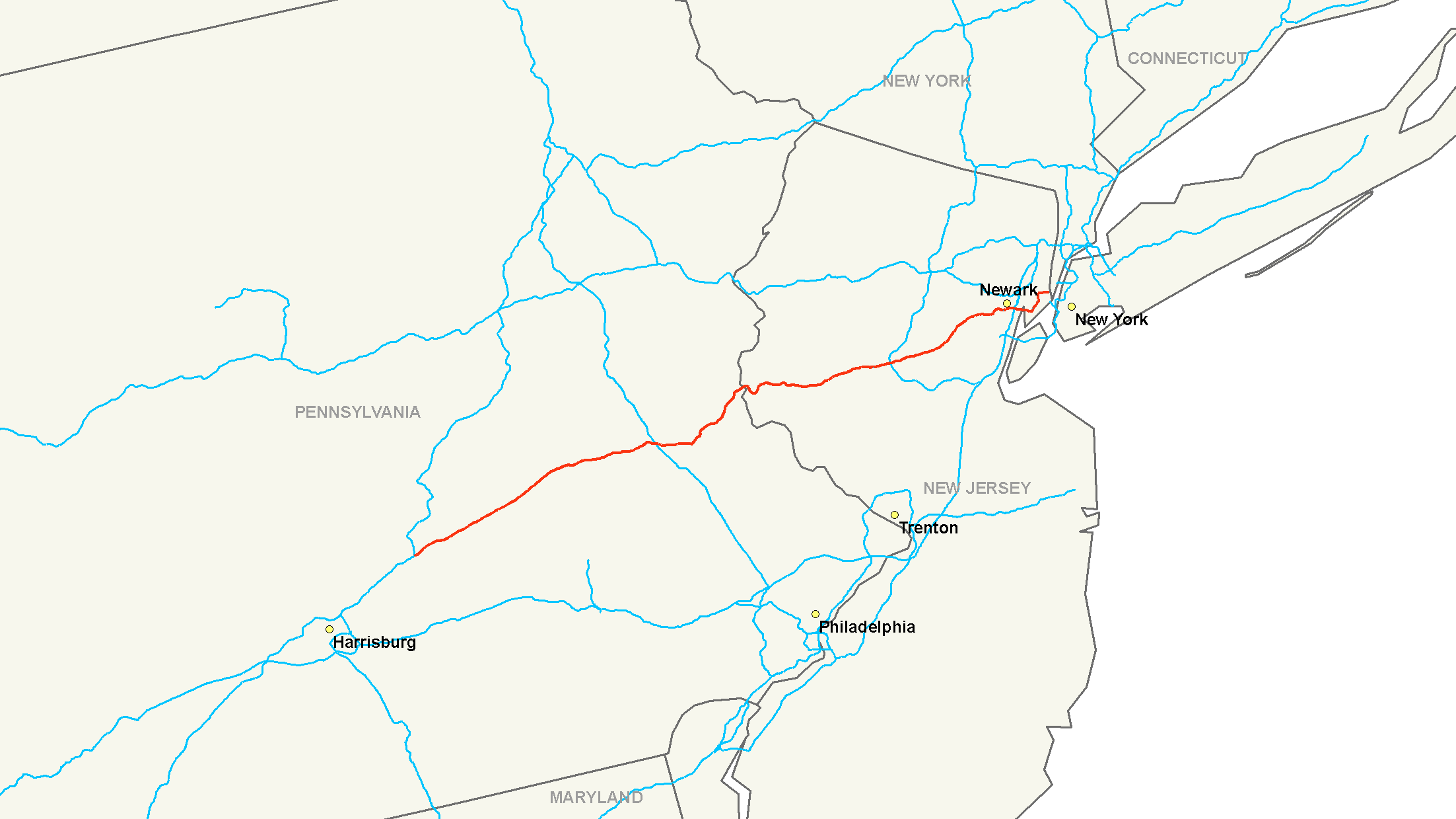
year_established=1957
length_mi=143.56
length_km=231.04
direction_a=West
direction_b=East
terminus_a=
terminus_b=Canal Street in Manhattan, NY
junction=
commons=categoryInterstate 78 (abbreviated I-78) is an
Interstate Highway in theNortheast United States , running 144 miles (231 km) from Interstate 81 northeast ofHarrisburg, Pennsylvania , throughAllentown, Pennsylvania , and western and northernNew Jersey to theHolland Tunnel and downtownNew York City .Route description
Pennsylvania
I-78 begins at a directional-T interchange with
Interstate 81 inUnion Township, Lebanon County, Pennsylvania , about 25 miles (40 km) northeast of Harrisburg. Near the east end of the county, at exit 8,U.S. Route 22 merges with I-78, running concurrent for the next 43 miles. [cite map|publisher=Google Maps |url=http://maps.google.com/maps?f=q&hl=en&geocode=&q=Bethel,+PA&ie=UTF8&ll=40.450605,-76.065216&spn=1.92281,3.641968&z=8&om=1|title=Overview Map of I-78 in Lebanon, Berks, and Lehigh Counties|accessdate=2007-08-31]At exit 51, in Upper Macungie Township, US 22 leaves the highway. Passengers traveling on I-78 eastbound must use this exit to access
I-476 (Northeast Extension of the Pennsylvania Turnpike ) and westbound travelers must use exit 53. From exits 53 to 60, I-78 is concurrent withPennsylvania Route 309 . The six lane overlap bypasses the City of Allentown to south and crosses South Mountain. [cite map|publisher=Google Maps|url=http://maps.google.com/maps?f=q&hl=en&geocode=&q=I-78,+Allentown,+PA&sll=40.486649,-76.065216&sspn=0.015014,0.028453&ie=UTF8&ll=40.570464,-75.538559&spn=0.239926,0.455246&z=11&om=1|title=Overview Map of I-78 southeast of Allentown|accessdate=2007-08-31] [cite map|publisher=Google Maps|url=http://maps.google.com/maps?f=q&hl=en&geocode=&q=I-78,+Allentown,+PA&sll=40.486649,-76.065216&sspn=0.015014,0.028453&ie=UTF8&ll=40.564294,-75.483027&spn=0.001875,0.003557&t=k&z=18&om=1|title=Overview Satellite Image of I-78 with six lanes|accessdate=2007-08-31]At exit 60 (A-B going westbound), PA 309 south leaves for the village of
Quakertown .cite web|author=Google Maps|url=http://maps.google.com/maps?hl=en&q=I-78,+PA&um=1&sa=N&tab=wl|title=Interstate 78 in Pennsylvania|accessdate=2007-08-31] Six miles later,Pennsylvania Route 412 interchanges with I-78 in Hellertown. Highway 412 also goes to Bethlehem andLehigh University . At mile marker 71.04,Pennsylvania Route 33 intersects at Exit 71. Route 33 traverses thePocono Mountains and goes to Bangor and Interstate 80. The final exit on Interstate 78 in Pennsylvania is for Morgan Hill Road, which goes toPennsylvania Route 611 and Easton. Interstate 78 then crosses theInterstate 78 Toll Bridge and entersNew Jersey .New Jersey
After the
Interstate 78 Toll Bridge , I-78 enters New Jersey as the "Phillipsburg-Newark Expressway".cite web|author=New Jersey Department of Transportation |url=http://www.state.nj.us/transportation/refdata/sldiag/00000078__-.pdf|title=Interstate 78 straight line diagram|accessdate=2007-08-31] The road begins by parallelling County Route 642 in the town of Alpha. At convert|3.94|mi|km, Exit 3, a partial cloverleaf interchange brings togetherU.S. Route 22 ,New Jersey Route 122 andNew Jersey Route 173 with Interstate 78 in Phillipsburg.cite web|author=Google Maps |url=http://maps.google.com/maps?hl=en&q=I-78,+New+Jersey,+United+States&um=1&sa=N&tab=wl|title=I-78, New Jersey, United States|accessdate=2007-08-31] U.S. Route 22 now becomes concurrent with 78 for the next convert|15|mi|km. Going westbound, exit 4 leaves to the right for County Route 637 and Warren Glen. The next exit, Exit 6, is for County Route 632 in Bloomsbury. However the route number is not signed on Interstate 78. Exit 7 is the first of several eastbounde exits for NJ 173. This one is located in Bloomsbury as 173 begins to parallel the interstate. Four miles later, Exit 11 leaves to the right as another Exit for NJ 173. Warren County 614 also is located off the exit. Exit 12, westbound is for NJ 173 again. However, Exit 12 eastbound is for afrontage road parallelling Interstate 78. Exit 13 is only westbound and is another exit for NJ 173. Nearby the exit, going eastbound, the frontage road merges in. Exit 15 is for NJ 173 and County Route 513 in Franklin Township. Exit 17 is for NJ 31 in Clinton. In the town of Annandale, US 22 leaves Interstate 78 at exit 18. Route 22 continues towards Bound Brook and Union County. At exit 20, Hunterdon CR 639 intersects. Hunterdon 639 heads towards the Round Valley Recreational Area. Exit 24 is for County Route 523 towards Oldwick. At exit 29,Interstate 287 ,U.S. Route 202 andU.S. Route 206 interchange with 78 in Bedminster. At this point, in Somerset County, Exits 33, 36 and 40 are for county routes in Warren Township. At exit 41, I-78 enters Union County. At exit 45, County Route 527 intersects after parallelling for some time. West of exit 48, I-78 splits into express and local carriageways. Exit 48 is forNew Jersey Route 24 in Springfield. Exit 49A is for one of route 24's spur routes,New Jersey Route 124 . Going westbound, Exit 52 is for theGarden State Parkway in Irvington. At Exits 57 and 58,New Jersey Route 21 ,U.S. Route 1 ,U.S. Route 9 andU.S. Route 22 intersect Interstate 78. The exit provides access to Newark Airport.East of exit 58 at the eastern tip of Newark, I-78 becomes the Newark Bay Extension of the
New Jersey Turnpike . Past the first toll plaza, I-78 interchanges Interstate 95 (New Jersey Turnpike) and crosses theNewark Bay via theNewark Bay Bridge . The first exit, 14A, is forNew Jersey Route 440 in Bayonne.Liberty State Park and theLiberty Science Center can be reached by taking Exit 14B. Exit 14C is the final numbered exit, providing access to theNew Jersey Turnpike .New Jersey Route 139 becomes concurrent with 78 as it approaches theHolland Tunnel and entersNew York .New York City
Its length in
New York is only 1/2 mile (1 km) - half of the Holland Tunnel and the plaza immediately beyond. The route was planned to run east and north through New York City to end at Interstate 95 inthe Bronx , but sections of the planned route, including theLower Manhattan Expressway , were cancelled.In New York City, I-78 continues through the Holland Tunnel plaza. The five separate exits from the tunnel are assigned numbers - exits 1 to 5 - in counterclockwise order. The last one - and the logical continuation east - is Exit 5, Canal Street. Under the original plans, I-78 was to continue acrossManhattan as theLower Manhattan Expressway onto theWilliamsburg Bridge , and then beyondI-278 on the never-built Bushwick Expressway throughBrooklyn intoQueens near theJFK Airport . A section of I-78 at the airport was built as theNassau Expressway , nowInterstate 878 , though most of the westbound side was never built. East of the airport, I-78 would have turned north on theClearview Expressway (built north of Hillside Avenue inQueens and now I-295), run across theThrogs Neck Bridge , and forked into two spurs, ending at I-95 via theThrogs Neck Expressway (now I-695) and theBruckner Interchange via theCross Bronx Expressway (now part of I-295). [ [http://www.dot.state.ny.us/tech_serv/high/tvwebpag.html NYSDOT - Traffic Count Information] ]Major intersections
*Interstate 81 in Union Township, Pennsylvania
*U.S. Route 22 in Union Township and Upper Macungie Township
*Interstate 476 via U.S. Route 22 near Allentown
*Interstate 287 in Bedminster, New Jersey
*U.S. Route 1-9 in Newark
*Interstate 95 (New Jersey Turnpike ) in NewarkAuxiliary routes
All of I-78's auxiliary routes serve New York City; however, none of these routes actually intersects I-78, following the route's truncation to the east end of the
Holland Tunnel .
*Interstate 278 runs fromU.S. Route 1/9 nearElizabeth, New Jersey over theGoethals Bridge , throughStaten Island , over theVerrazano Narrows Bridge and throughBrooklyn andQueens , and across theTriborough Bridge intothe Bronx to end at I-95 at theBruckner Interchange . I-278 was planned to extend west from Elizabeth to I-78 inUnion Township, Union County, New Jersey , and was to intersect I-78 at the east end of theWilliamsburg Bridge in Brooklyn. Until 1972, I-278 ran along Interstate 895 and a proposed extension to I-95, while I-278 east of I-895 was I-878.
*Interstate 478 is an unsigned designation for theBrooklyn-Battery Tunnel , a spur from I-278 intolower Manhattan . Plans were made to continue it north along theWest Side Highway (Route 9A) to I-78 at the Holland Tunnel, but have been canceled. Older plans would have given it the same purpose - connecting I-78 with I-278 - but along theManhattan Bridge .
*Interstate 678 runs from I-278 at theBruckner Interchange south over theBronx-Whitestone Bridge toJohn F. Kennedy International Airport . It was to intersect I-78 at its south end. Original plans took I-678 west on theGrand Central Parkway to I-278.
*Interstate 878 is an unsigned designation for part ofNew York State Route 878 , a short east-west freeway on the north edge ofJFK Airport . It was once planned as part of I-78, and now intersects I-678. The number was assigned in 1989.
*A former Interstate 878 existed from 1959 to 1972 along present I-278 east of Interstate 895. (I-895 was part of I-278.)In eastern Pennsylvania, Route 378 into downtown Bethlehem was onceInterstate 378 , but was redesignated as a state route after I-78 was rerouted to a new southerly alignment. An Interstate 178 was initially planned as an extension into downtown Allentown, but was cancelled due to local opposition.References
Wikimedia Foundation. 2010.