- Clinton Township, New Jersey
-
For the former township, see Clinton Township, Essex County, New Jersey.
Clinton Township, New Jersey — Township — Map of Clinton Township in Hunterdon County. Inset: Location of Hunterdon County highlighted in the State of New Jersey.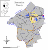 Census Bureau map of Clinton Township, New Jersey
Coordinates: 40°37′51″N 74°52′6″W / 40.63083°N 74.86833°WCoordinates: 40°37′51″N 74°52′6″W / 40.63083°N 74.86833°W Country United States State New Jersey County Hunterdon Incorporated April 12, 1841 Government[1] – Type Faulkner Act (Small Municipality) – Mayor Kevin Cimei (2012)[2] – Administrator Marvin Joss[3] Area – Total 33.9 sq mi (87.9 km2) – Land 30.0 sq mi (77.7 km2) – Water 3.9 sq mi (10.2 km2) Elevation[4] 427 ft (130 m) Population (2010 Census)[5] – Total 13,478 – Density 397.6/sq mi (153.3/km2) Time zone Eastern (EST) (UTC-5) – Summer (DST) EDT (UTC-4) ZIP code multiple Area code(s) 908 FIPS code 34-13750[6][7] GNIS feature ID 0882177[8] Website http://www.township.clinton.nj.us/ Clinton Township is a Township in Hunterdon County, New Jersey, United States. As of the United States 2010 Census, the township population was 13,478.[5]
Clinton Township was incorporated as a township by an Act of the New Jersey Legislature on April 12, 1841, from portions of Lebanon Township, based on the results of a referendum held that same day. Portions of the township have been take to form Clinton town (April 5, 1865, within the township; became independent in 1895), High Bridge township (March 29, 1871) and Lebanon borough (March 26, 1926).[9]
Annandale is a census-designated place and unincorporated area located within Clinton Township.
Contents
Geography
According to the United States Census Bureau, the township has a total area of 33.9 square miles (88 km2), of which, 30.0 square miles (78 km2) of it is land and 3.9 square miles (10 km2) of it (11.58%) is water.
Cushetunk Mountain is a ring-shaped mountain located in Readington Township and Clinton Township. Once an active volcano, the diabase mountain was formed 160 million years ago.[10] The Lenape called the mountain "Cushetunk" meaning "place of hogs" after the wild hogs found there.[11] In the 1960s, the valley was filled with water to create Round Valley Reservoir.

High Bridge Lebanon Twp Tewksbury Twp Town of Clinton
and Union Twp
 Clinton Twp

Franklin Township Raritan Twp Readington Twp Also, Lebanon is an independent municipality located entirely within the township.
Demographics
Historical populations Census Pop. %± 1930 1,856 — 1940 2,349 26.6% 1950 2,926 24.6% 1960 3,770 28.8% 1970 5,119 35.8% 1980 7,345 43.5% 1990 10,816 47.3% 2000 12,957 19.8% 2010 13,478 4.0% Population sources:
1930 - 1990[12] 2000[13] 2010[5]As of the census[6] of 2000, there were 12,957 people, 4,129 households, and 3,253 families residing in the township. The population density was 431.9 people per square mile (166.8/km²). There were 4,234 housing units at an average density of 141.1 per square mile (54.5/km²). The racial makeup of the township was 87.71% White, 6.96% African American, 0.20% Native American, 2.35% Asian, 0.07% Pacific Islander, 1.59% from other races, and 1.12% from two or more races. Hispanic or Latino of any race were 3.91% of the population.[13]
There were 4,129 households out of which 42.1% had children under the age of 18 living with them, 73.1% were married couples living together, 4.1% had a female householder with no husband present, and 21.2% were non-families. 17.4% of all households were made up of individuals and 5.1% had someone living alone who was 65 years of age or older. The average household size was 2.82 and the average family size was 3.23.[13]
In the township the population was spread out with 26.2% under the age of 18, 11.1% from 18 to 24, 28.8% from 25 to 44, 26.5% from 45 to 64, and 7.3% who were 65 years of age or older. The median age was 36 years. For every 100 females there were 118.4 males. For every 100 females age 18 and over, there were 124.8 males.[13]
The median income for a household in the township was $96,570, and the median income for a family was $106,448. Males had a median income of $77,229 versus $46,762 for females. The per capita income for the township was $37,264. About 0.3% of families and 0.9% of the population were below the poverty line, including none of those under age 18 and 3.6% of those age 65 or over.[13]
Government
Local government
Clinton Township is governed by the Faulkner Act (Small Municipality) form of government. The Faulkner Act allows municipalities to adopt a Small Municipality form of government only for municipalities with a population of under 12,000. The government consists of a Mayor and a four-member Township Council, with all positions elected at large in partisan elections. A Mayor is elected directly by the voters to a three-year term of office. Council members serve a term of three years, which are staggered so that two seats come up for election each year that the Mayor's seat does not.[1]
The Mayor is the township's executive official and is responsible for selecting the Municipal Clerk and Assessor, which are subject to confirmation by the Township Council. The Council is the township's legislative body and is responsible for ordinances, resolutions and the annual budget, as well as most hiring other than those positions delegated to the mayor. The mayor presides over and is eligible to vote at council meetings, but has no veto power.[14]
As of 2011[update], the Clinton Township Council consists of Mayor Kevin Cimei (term ends December 31, 2011), Jim Imbriaco (2012), John Lazarus (2013), Peter Marra (2012) and Harmen Vos (2013).[15]
Federal, state and county representation
Clinton Township is in the 7th Congressional district and is part of New Jersey's 23rd state legislative district.[16] The legislative district was kept unchanged by the New Jersey Apportionment Commission based on the results of the 2010 Census.[5]
New Jersey's Seventh Congressional District is represented by Leonard Lance (R, Clinton Township). New Jersey is represented in the United States Senate by Frank Lautenberg (D, Cliffside Park) and Bob Menendez (D, Hoboken).
23rd Legislative District (New Jersey) of the New Jersey Legislature, which is represented in the New Jersey Senate by Michael J. Doherty (R, Oxford Township) and in the New Jersey General Assembly by John DiMaio (R, Hackettstown) and Erik Peterson (R, Franklin Township).[17] The Governor of New Jersey is Chris Christie (R, Mendham).[18] The Lieutenant Governor of New Jersey is Kim Guadagno (R, Monmouth Beach).[19]
Hunterdon County is governed by a five-member Board of Chosen Freeholders, who serve three-year terms of office at-large, with either one or two seats up for election each year on a staggered basis.[20] As of 2011, Hunterdon County's Freeholders are Freeholder Director Matt Holt (Clinton Town), Freeholder Deputy Director Robert Walton (Hampton), William Mennen (Tewksbury Township),George B. Melick (Tewksbury Township), and Ronald Sworen (Frenchtown).[21]
Politics
Like most towns in Hunterdon County, Clinton Township leans very strongly towards Republican Party on the national and state levels.[22] In the 2004 Presidential Election, Clinton Township voters gave George W. Bush 4,389 votes (64.6% of the vote), to John Kerry's 2,340 (34.5%) out of 6,789 total votes cast.[23] In the 2008 Presidential Election, Republican John McCain received 59% of the vote, defeating Democrat Barack Obama, who received around 39%.[24] In the 2009 Gubernatorial Election, Republican Chris Christie received 70% of the vote, defeating Democrat Jon Corzine, who received around 20%.[22]
Education
The Clinton Township School District serves approximately 1,700 children in grades Pre-K through 8. Schools in the district (with 2009-10 school enrollment data from the National Center for Education Statistics[25]) are Spruce Run Elementary School (PreK-1; 326 students), Patrick McGaheran School (2&3; 333 students), Round Valley School (4-6; 605 students) and Clinton Township Middle School (7&8; 445). Students in grades 7 and 8 from Lebanon Borough attend the district as part of a sending/receiving relationship with the Lebanon Borough School District.[26]
Public school students in grades 9 through 12 attend North Hunterdon High School in Annandale as part of the North Hunterdon-Voorhees Regional High School District. in addition to students from Clinton Township, North Hunterdon High School serves students from Bethlehem Township, Clinton Town, Franklin Township, Lebanon Borough and Union Township.[27]
Transportation
Annandale is a New Jersey Transit railroad station on the Raritan Valley Line, in the Annandale section of Clinton Township. There is a station building that is no longer used and there are two small shelters. This station has limited weekday service and no weekend service.
Interstate 78, Route 22 and Route 31 all pass through Clinton Township.
Notable residents
Notable current and former residents of Clinton Township include:
- Leonard Lance (born 1952), member of the United States House of Representatives.[28]
References
- ^ a b 2005 New Jersey Legislative District Data Book, Rutgers University Edward J. Bloustein School of Planning and Public Policy, April 2005, p. 103.
- ^ 2011 New Jersey Mayors Directory, New Jersey Department of Community Affairs. Accessed July 20, 2011.
- ^ Administrator and Clerk, Clinton Township. Accessed July 2011.
- ^ U.S. Geological Survey Geographic Names Information System: Township of Clinton, Geographic Names Information System, accessed January 4, 2008.
- ^ a b c d 2011 Apportionment Redistricting: Municipalities sorted alphabetically, New Jersey Department of State, p. 2. Accessed July 20, 2011.
- ^ a b "American FactFinder". United States Census Bureau. http://factfinder.census.gov. Retrieved 2008-01-31.
- ^ A Cure for the Common Codes: New Jersey, Missouri Census Data Center. Accessed July 14, 2008.
- ^ "US Board on Geographic Names". United States Geological Survey. 2007-10-25. http://geonames.usgs.gov. Retrieved 2008-01-31.
- ^ "The Story of New Jersey's Civil Boundaries: 1606-1968", John P. Snyder, Bureau of Geology and Topography; Trenton, New Jersey; 1969. p. 154
- ^ Round Valley
- ^ Cushetunk Mountain
- ^ New Jersey Resident Population by Municipality: 1930 - 1990, Workforce New Jersey Public Information Network, backed up by the Internet Archive as of May 2, 2009. Accessed July 6, 2011.
- ^ a b c d e Census 2000 Demographic Profile Highlights: Clinton township, Hunterdon County, New Jersey, United States Census Bureau. Accessed July 20, 2011.
- ^ Form of Government, Clinton Township. Accessed July 20, 2011.
- ^ Mayor and Council, Clinton Township. Accessed March 13, 2011.
- ^ 2011 New Jersey Citizen's Guide to Government, New Jersey League of Women Voters, p. 56. Accessed July 20, 2011.
- ^ "Legislative Roster: 2010-2011 Session". New Jersey Legislature. http://www.njleg.state.nj.us/members/roster.asp. Retrieved 2010-07-25.
- ^ "About the Governor". New Jersey. http://www.nj.gov/governor/about/. Retrieved 2010-01-21.
- ^ "About the Lieutenant Governor". New Jersey. http://www.nj.gov/governor/lt/. Retrieved 2010-01-21.
- ^ About the Board, Hunterdon County, New Jersey. Accessed January 5, 2011.
- ^ Hunterdon County Board of Chosen Freeholders, Hunterdon County, New Jersey. Accessed February 9, 2011.
- ^ a b "Governor Hunterdon County". State of New Jersey. 2009. http://www.state.nj.us/state/elections/election-results/2009-governor_results-hunterdon.pdf. Retrieved 2010-04-23.
- ^ 2004 General Election Official Results - Clinton Township, accessed May 15, 2006
- ^ "Presidential Election Results Hunterdon County". State of New Jersey. 2009. http://www.state.nj.us/state/elections/election-results/08-gen-elect-presidential-results-hunterdon.pdf. Retrieved 2010-04-23.
- ^ Data for the Clinton Township School District, National Center for Education Statistics. Accessed July 20, 2011.
- ^ Clinton Township Middle School 2010 Report Card narrative, New Jersey Department of Education. Accessed July 20, 2011. "The Clinton Township Middle School opened its doors in September 2007 as the newest school in the district. It serves approximately 463 seventh and eighth grade students. The student body is comprised Clinton Township and Lebanon Borough students."
- ^ About the North Hunterdon-Voorhees Regional High School District, North Hunterdon-Voorhees Regional High School District. Accessed July 20, 2011. "North Hunterdon High School educates students from: Bethlehem Township, Clinton Town, Clinton Township, Franklin Township, Lebanon Borough, Union Township"
- ^ Staff. "Congressman Leonard Lance of Clinton Twp. should help return civility to political dialog", Hunterdon County Democrat, January 20, 2011. Accessed July 20, 2011. "That’s good news for Republican Congressman Leonard Lance, a Clinton Township resident, who won re-election in November to represent the 7th Congressional District, which includes much of Hunterdon County. "
External links
- Clinton Township website
- Hunterdon County webpage for Clinton Township
- Clinton Township School District
- Clinton Township School District's 2009–10 School Report Card from the New Jersey Department of Education
- Data for the Clinton Township School District, National Center for Education Statistics
- North Hunterdon-Voorhees Regional High School District
- Hunterdon Land Trust Alliance
- Fire Department
Municipalities and communities of Hunterdon County, New Jersey City 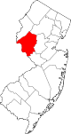
Boroughs Bloomsbury | Califon | Flemington | Frenchtown | Glen Gardner | Hampton | High Bridge | Lebanon | Milford | Stockton
Town Townships Alexandria | Bethlehem | Clinton | Delaware | East Amwell | Franklin | Holland | Kingwood | Lebanon | Raritan | Readington | Tewksbury | Union | West Amwell
CDPs Communities Oldwick | Pittstown | Pottersville | Raven Rock | Readington Village | Ringoes | Sergeantsville | Stanton | Three Bridges | Whitehouse
Categories:- 1841 establishments in the United States
- Faulkner Act Small Municipality
- Populated places established in 1841
- Townships in Hunterdon County, New Jersey


Wikimedia Foundation. 2010.