- Mid-Delaware Bridge
-
Mid-Delaware Bridge 
Bridge seen from Port Jervis side, upriverCarries Four lanes of US 6/US 209 Crosses Delaware River Locale Port Jervis, New York-Matamoras, Pennsylvania, USA Maintained by Joint Interstate Bridge Commission Design Continuous steel truss Total length 659 feet (201 m)[1] Width 44 feet (13.4 m)[1] Clearance below 25 feet (7.6 m)[1] Construction end 1939[1] Location of bridge within Matamoras and Port Jervis 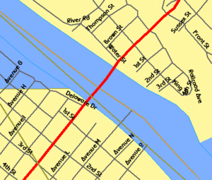
Coordinates 41°22′18″N 74°41′52″W / 41.37167°N 74.69778°WCoordinates: 41°22′18″N 74°41′52″W / 41.37167°N 74.69778°W The Mid-Delaware Bridge, sometimes known as the Port Jervis-Matamoras Bridge or the Fourth Barrett Bridge, is a continuous truss bridge which carries U.S. Routes 6 and 209 across that river between those two communities and thus the states of New York and Pennsylvania. It is the only four-lane bridge on the upper main stem of the Delaware.[1]
Contents
History
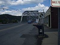 Bridge seen from US 6 and 209 on the Pennsylvania side
The current bridge, built by R.C. Ritz Construction Company in 1939 at a cost of $380,000, is the most recent in a long history of crossings between the two communities.[2] It began in the mid-19th century, when the local Milford and Matamoras Railroad settled a dispute with the larger, growing Erie Railroad with the latter's assent to a law requiring that it construct a bridge across the Delaware at Matamoras that could carry both road and rail traffic. It was supposed to have been completed by 1852, but due to the railroad's unsuccessful efforts to have the law requiring the bridge declared unconstitutional it only began building it that year. It was finished in 1854.[3]
In 1870 that bridge was destroyed in a storm. Directors of the Milford and Matamoras confronted Jay Gould about this in New York when the Erie showed no apparent interest in immediately rebuilding it. He told them the railroad had sold its interest in the bridge to another company, which turned out to be a dummy corporation. A new railroad bridge was built upstream
Port Jervis businessmen led by Charles St. John frustrated by the delays formed the Barrett Bridge Company to build a suspension bridge designed by John A. Roebling. The bridge which had two spans of 325 feet (99 m) opened in 1872.[4] In March 1875 an ice dam on the Delaware upstream broke and in the ensuing flood, it took out the newly built railroad bridge above the Barrett Bridge. The rail bridge then took out sections of the Barrett Bridge which floated 25 miles (40 km) downstream but were relatively undamaged. They were carted back and reassembled within a few weeks.[5][6]
It lasted until its destruction in the severe flood of October 1903.[7] A new Barrett Bridge was built shortly thereafter, using a design similar to the current bridge. In 1922 it was taken over by the new Joint Interstate Bridge Commission set up by the two states to manage their Delaware River bridges; tolls were eliminated. The toll house on the Port Jervis side still stands and has been incorporated into the popular Flo-Jean restaurant.[2]
The Barrett Bridge was finally retired in the late 1930s due to increasing auto and truck traffic, and the present structure built. It would be the only crossing in the area until Interstate 84 was completed in the 1960s with a bridge less than a mile downstream. The Mid-Delaware has proven hardier than its predecessors, standing firm through the post-hurricane flooding in 1955.[2] However, it was closed during the 2006 flooding due to the river waters overrunning its approach roads on either side.[8]
In June 2007, the Commission approved $550,000 worth of work to be completed in 2008. The abutment backwalls on both sides, and the pier expansion dam, will be repaired.[9]
See also
References
- ^ a b c d e Arbeitsblatt 3, retrieved June 9, 2007.
- ^ a b c Frank, Dale T.; Bridges over the Delaware River: A History Of Crossings, Rutgers University Press, New Brunswick, NJ, ISBN 0813532124, 2003, 139.
- ^ Ehrenreich, Thomas; 2001; "The story of a little railroad and a big bridge; Railroad Extra; retrieved from catskillarchive.com June 9, 2007.
- ^ http://www.usgennet.org/usa/ny/county/orange/pj/
- ^ The Wreck of the Barrett Bridge at Port Jervis - New York Times - March 21, 1875
- ^ The Port Jervis Flood - New York Times - March 18, 1875
- ^ Denenberg, David; 1872 Barrett; retrieved from bridgemeister.com June 9, 2007.
- ^ June 29, 2006; Raging floodwaters leave towns ravaged; WABC-TV; retrieved June 9, 2007.
- ^ June 8, 2007; Bi-state commission sets work plan for Upper Delaware Bridges; pocononews.net; retrieved June 9, 2007.
External links
- Port Jervis/Matamoras Bridge 6/28/06 Video from Times-Herald Record New Media showing 2006 flood at its height around bridge.
Crossings of the Delaware River Upstream
Pond Eddy BridgeMid-Delaware Bridge


Downstream
Interstate 84 Bridge
 Categories:
- Bridges in Orange County, New York
- Bridges completed in 1939
- Port Jervis, New York
- Bridges over the Delaware River
- U.S. Route 6
- Continuous truss bridges
- Bridges in Pike County, Pennsylvania
- Road bridges in New York
- Road bridges in Pennsylvania


Wikimedia Foundation. 2010.