- Pennsylvania Route 115
-
PA Route 115
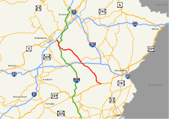
Major roads in the Poconos with PA 115 in redRoute information Maintained by PennDOT Length: 35.5 mi[2] (57.1 km) Existed: 1928[1] – present Major junctions South end:  US 209 in Brodheadsville
 I-80 in Tobyhanna Township

 I-476/Turnpike in Bear Creek Township
North end: 
 I-81/PA 309 near Wilkes-Barre
Location Counties: Luzerne, Monroe Highway system Roads in Pennsylvania
Interstate • US • State • Legislative←  PA 114
PA 116  →
→←  US 15
US 15
PA 16  →
→←  PA 438
PA 441  →
→Pennsylvania Route 115 (also known by the Pennsylvania Department of Transportation as SR 115) is a 35.1-mile (56.5 km) north–south state highway in eastern Pennsylvania. It stretches from U.S. Route 209 in Brodheadsville to Interstate 81 and Pennsylvania Route 309 near Wilkes-Barre. The road originated as the Sullivan Trail which later became known as the Easton and Wilkes-Barre Turnpike. The road serves as a connector between The Poconos and the Wyoming Valley.
Contents
Route description
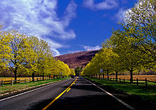 Former PA 115 near Wind Gap
PA 115 starts at a Y intersection with U.S. Route 209 in Brodheadsville. In Tunkhannock Township, PA 115 meets the northern terminus of Pennsylvania Route 903. In Tunkhannock Township is also the home of Pocono Raceway. In Tobyhanna Township, PA 115 intersects Interstate 80 at exit 284. North of I-80, PA 115 meets Pennsylvania Route 940 in the town of Blakeslee. In Bear Creek Village, PA 115 is called Bear Creek Boulevard and intersects Interstate 476 the Pennsylvania Turnpike at exit 105 (Wilkes-Barre interchange). In Plains Township outside of Wilkes-Barre, PA 115 terminates (ends) at an interchange with Interstate 81 (exit 170) and Pennsylvania Route 309 (North Cross Valley Expressway).
History
Old roads
PA 115 from Easton to Wilkes-Barre was originally a pathway made by General John Sullivan and his forces in 1779 during the American Revolution on their expedition from Easton to the Wyoming Valley. George Washington ordered Sullivan to march upstream the Susquehanna River to join General James Clinton's brigade at the Bradford County town of Tioga (now known as Athens). Soon after, Sullivan's army departed to Newtown, New York where they defeated the Iroquois and Cayuga Indians living in Western New York. His campaign was one of the most important military movements in the American Revolution. Some segments of the original path still remain today on PA 115 as Sullivan Trail.[3]
At the turn of the 19th century, the population and economy of Luzerne County continued to grow and there was a necessity for new roads to improve communication between distant settlements. Most of the early merchandise transportation in the area was done by Durham boats on the Lehigh and Susquehanna Rivers. This led Arnold Colt, a Luzerne County clerk, to construct a turnpike directly connecting the Wyoming and Lehigh Valleys on Sullivan's Trail. Colt then obtained a charter to incorporate the Easton and Wilkes-Barre Turnpike on February 11, 1803. The first 46 miles (74 km) of the turnpike from Wilkes-Barre to Wind Gap were finished by 1807. The road was completed by 1815 at a total expense of US$75,000.[3][4]
They are building a plank road to Slocum Hollow (now Scranton) to get to a railroad and they say that a man can get from Wilkes-Barre to New York in a day. It is almost beyond my belief. I wonder what will become of the old turnpike there is no more use for the old man and the old road.
The turnpike was initially used as major thoroughfare for conveying grains and plaster during War of 1812. When Northampton County farmers could not afford shipped plaster from the Eastern seaboard they became interested in New York plaster. The plaster was transported from New York via the Susquehanna River then onto the turnpike on wagons and sleds. Transporting this product became the turnpike's legacy as it transformed the road into an important commercial line.[5]
By the 1850s, the transport industry heavily favored trains over wagons and sleds. In 1851, the Lackawanna and Western Railroad was completed, connecting Scranton to upstate New York. The new railroad shortened the time required to ship goods between the two endpoints from ten days (by way of roads) to just one. The amount of traffic on the turnpike declined as a result. By the 1850s, the turnpike company had folded and the highway was abandoned.[6] From Bear Creek to Tobyhanna Township the name Easton and Wilkes-Barre Road is still marked on PA 115. The former southern extension of PA 115 from Brodheadsville to Wind Gap is marked as the Wilkes-Barre Turnpike.[7][8]
Designation
 PA 15 (1927-1928)
When Pennsylvania began maintenance over roads by the way of the Sproul Road Bill in May 1911,[9] the Luzerne County portion of present-day PA 115 was adopted as Legislative Route 169, the primary connector between Wilkes-Barre and the Poconos. The former southernmost segment of the route from Saylorsburg to Easton was adopted as Legislative Route 166.[10] The first traffic routes were assigned in 1924[11] and by 1927, the state had assigned LR 169 as Pennsylvania Route 15 only to be renumbered the following year as PA 115.[1]
When PA 115 was commissioned in 1928, the road was mostly aligned east–west and stretched from U.S. Route 220 in Montoursville to U.S. Route 611 in Mount Pocono. From Swiftwater to Tobyhanna Township the road followed present-day Pennsylvania Routes 940 and 314. The former routing from Montoursville to Wilkes-Barre became Pennsylvania Routes 309, 118, 154, and 87.[12] During the Great Depression, the southern branch of PA 115 was lengthened to U.S. Route 611 in Easton on the Sullivan Trail and the northern terminus was moved to the Montour County municipality of Mausdale along Pennsylvania Routes 254 and 642.[13][14]
After World War II, PA 115 was extended west to Pennsylvania Route 14 (currently PA 405) in Milton on modern PA 642.[15] The northern terminus was moved from Milton to U.S. Route 220 in Hughesville during the 1950s; this segment of the road followed what is now PA 118. By 1960, PA 115 was moved onto a limited-access road (now PA 33) from Saylorsburg to Pennsylvania Route 512.[16] The portion of PA 115's former surface alignment in Northampton County between Center Square in Easton and PA 191 in Stockertown is now designated as State Route 2025, an unsigned quadrant route.[17] By 1962, the northern terminus of PA 115 was moved from Hughesville to U.S. Route 309 (now PA 309 Business) in Wilkes-Barre Township.[18] In Wilkes-Barre, it used to followed Kidder Street, Butler Street, Main Street, Courtright Street, Carey Avenue, and crossed the Susquehanna River on Pierce Street.[19]
By 1972, the southern terminus was truncated from Easton to its current location.[20] The road followed Sullivan Trail, Third Street, College Avenue, Catell Avenue, and Knox Avenue through Easton.[19] PA 115 was extended back to its former alignments by 1980 via Kidder, Scott, Butler, and Pierce Streets through Wilkes-Barre and ended at U.S. Route 11 in Kingston.[21] The route was truncated to PA 309 at the intersection of Kidder and Spring Streets in Wilkes-Barre by 1989. A year later, the northern terminus was moved to its current location when the North Cross-Valley Expressway (PA 309) was completed.[22][23]
Major intersections
County Location Mile[2] Destinations Notes Monroe Brodheadsville 0.0 

 US 209 to PA 715
Tunkhannock 13.4  PA 903
Northern terminus of PA 903. Tobyhanna Township 15.3 I-80Exit 284 (I-80). 16.7  PA 940
Luzerne Bear Creek Village 31.4 I-476/Pa TpkExit 105 (Wilkes-Barre) (I-476/PA Turnpike). Plains Township 35.5 I-81/PA 309Exit 170 (I-81/PA 309). 1.000 mi = 1.609 km; 1.000 km = 0.621 mi References
- ^ a b Pennsylvania Department of Highways (1927). Pennsylvania Highway Map (Map). http://www.mapsofpa.com/roadcart/1927_2043m.jpg. Retrieved 2009-08-19.
- ^ a b Google, Inc. Google Maps – Pennsylvania Route 115 (Map). Cartography by Google, Inc. http://maps.google.com/maps?f=d&source=s_d&saddr=Brodheadsville,+Pennsylvania&daddr=PA-115+to:PA-115+to:PA-115+to:PA-115%2FWilkes-Barre+and+Easton+Rd+to:Bear+Creek+Blvd%2FPA-115+to:41.251484,-75.81871&geocode=FSRxcAIdj4aB-w%3BFUR-cgIdeil_-w%3BFfLGcgIdPsh--w%3BFcoDcwIdH49--w%3BFcBadAIdaAF9-w%3BFfi9dAIdln97-w%3B&hl=en&mra=dme&mrcr=4&mrsp=6&sz=12&via=4&sll=41.229282,-75.793648&sspn=0.113094,0.220757&ie=UTF8&ll=41.151774,-75.723267&spn=0.452912,0.883026&z=10. Retrieved 2009-08-20.
- ^ a b Bradsby, Henry C. (1893). History of Luzerne County, Pennsylvania with Biographical Selections Vol. 1. S. B. Nelson. pp. 127, 128, 129, 254, 534, 571, 638. http://books.google.com/books?id=4BkVAAAAYAAJ&pg=PR1#v=onepage&q=&f=false. Retrieved 2009-08-20.
- ^ Report, Volume 5, Part 3. Pennsylvania. Bureau of Industrial Statistics, Pennsylvania. Dept. of Internal Affairs, Pennsylvania. Bureau of Statistics of Labor and Agriculture. 1878. p. 592. http://books.google.com/books?id=FKjNAAAAMAAJ&dq=Wilkes-Barre%20Turnpike&lr=&pg=PA592#v=onepage&q=Wilkes-Barre%20Turnpike&f=false. Retrieved 2009-08-21.
- ^ a b Historical Record : the early history of Wyoming valley and contiguous territory Vol. 4-6. Press of the WilkesBarre Record. 1893. p. 11. http://books.google.com/books?id=G0cVAAAAYAAJ&dq=%22Easton%20Turnpike%22&lr=&pg=RA2-PA11#v=onepage&q=%22Easton%20Turnpike%22&f=false. Retrieved 2009-08-21.
- ^ History of Hanover Township: including Sugar Notch, Ashley, and Nanticoke boroughs : and also a history of Wyoming Valley, in Luzerne County, Pennsylvania. R. Baur. 1885. p. 248. http://books.google.com/books?id=OOMtAAAAYAAJ&dq=%22Wilkes-Barre%20turnpike%22%20maintained&pg=PA248#v=onepage&q=%22Wilkes-Barre%20turnpike%22%20maintained&f=false.
- ^ The Historical record of Wyoming Valley, Volumes 13-14. Press of the Wilkes-Barre Record. 1905. p. 200. http://books.google.com/books?id=uxUUAAAAYAAJ&dq=%22Easton%20Turnpike%22&lr=&pg=RA1-PA200#v=onepage&q=%22Easton%20Turnpike%22&f=false. Retrieved 2009-08-20.
- ^ "A pioneer family's fall; the history opened by the Drinker-Cooper tragedy. Henry Drinker's energy, which settled a large part of Pennsylvania and brought riches to himself" (PDF). New York Times. July 7, 1884. http://query.nytimes.com/mem/archive-free/pdf?res=9903E3DD143FE533A25754C0A9619C94659FD7CF. Retrieved 21 August 2009.
- ^ Ihmsen, JD (May 16, 1911). "Utilities and Road Bills Are Passed". The Pittsburgh Gazette Times. http://news.google.com/newspapers?id=JB8NAAAAIBAJ&sjid=M2YDAAAAIBAJ&pg=4420,2203476&dq=sproul+road+bill. Retrieved 23 August 2009.
- ^ Pennsylvania Department of Highways. 1911 State Highway Map (Map). ftp://ftp.dot.state.pa.us/public/pdf/BPR_pdf_files/Maps/Statewide/Historic_OTMs/1911.pdf. Retrieved 2008-08-22.
- ^ "U.S. 22 - The William Penn Highway History - Pennsylvania's Named Highways". Federal Highway Administration. http://www.fhwa.dot.gov/infrastructure/us22.cfm#Pennsylvania's_Named_Highways. Retrieved 22 August 2009.
- ^ Pennsylvania Department of Highways. 1930 State Highway Map (front) (Map). ftp://ftp.dot.state.pa.us/public/pdf/BPR_pdf_files/Maps/Statewide/Historic_OTMs/1930fr.pdf. Retrieved 2008-08-22.
- ^ Pennsylvania Department of Highways. 1937 State Highway Map (Map). http://www.mapsofpa.com/roadcart/1937_1044m.jpg. Retrieved 2008-08-22.
- ^ Pennsylvania Department of Highways. 1940 State Highway Map (front) (Map). ftp://ftp.dot.state.pa.us/public/pdf/BPR_pdf_files/Maps/Statewide/Historic_OTMs/1940fr.pdf. Retrieved 2008-08-22.
- ^ Pennsylvania Department of Highways. 1950 State Highway Map (front) (Map). ftp://ftp.dot.state.pa.us/public/pdf/BPR_pdf_files/Maps/Statewide/Historic_OTMs/1950fr.pdf. Retrieved 2008-08-22.
- ^ Pennsylvania Department of Highways. 1960 State Highway Map (front) (Map). ftp://ftp.dot.state.pa.us/public/pdf/BPR_pdf_files/Maps/Statewide/Historic_OTMs/1960fr.pdf. Retrieved 2008-08-22.
- ^ "Northampton County Map of State Routes". PennDOT. ftp://ftp.dot.state.pa.us/public/pdf/BPR_pdf_files/MAPS/TR&SR_type3/northampton_T3.PDF. Retrieved 2009-01-02.
- ^ United States Geological Survey (1962). Scranton quadrangle (Map). http://www.lib.utexas.edu/maps/topo/250k/txu-pclmaps-topo-us-scranton-1962.jpg. Retrieved 2008-08-24.
- ^ a b Pennsylvania Department of Highways. 1960 State Highway Map (back) (Map). ftp://ftp.dot.state.pa.us/public/pdf/BPR_pdf_files/Maps/Statewide/Historic_OTMs/1960bk.pdf. Retrieved 2008-08-22.
- ^ Pennsylvania Department of Transportation. 1972 Luzerne County Map (Map). ftp://ftp.dot.state.pa.us/public/pdf/BPR_PDF_FILES/Maps/Type_10_GHS_Historical_Scans/Monroe_1972.pdf. Retrieved 2008-08-22.
- ^ Pennsylvania Department of Highways. 1980 State Highway Map (back) (Map). ftp://ftp.dot.state.pa.us/public/pdf/BPR_pdf_files/Maps/Statewide/Historic_OTMs/1980bk.pdf. Retrieved 2008-08-22.
- ^ Pennsylvania Department of Highways. 1989 State Highway Map (back) (Map). ftp://ftp.dot.state.pa.us/public/pdf/BPR_pdf_files/Maps/Statewide/Historic_OTMs/1989bk.pdf. Retrieved 2008-08-22.
- ^ Pennsylvania Department of Transportation. 1990 Luzerne County Map (Sheet 1) (Map). ftp://ftp.dot.state.pa.us/public/pdf/BPR_PDF_FILES/Maps/Type_10_GHS_Historical_Scans/Luzerne_1990_Sheet_1.pdf. Retrieved 2008-08-22.
External links
- Kitsko, Jeffrey J. (2009). "PA 115". Pennsylvania Highways. http://www.pahighways.com/state/PA101-150.html#PA115. Retrieved August 20, 2009.
Roads of the Wyoming Valley Interstate Highways Expressways U.S. Routes Pennsylvania Routes Categories:- State highways in Pennsylvania


Wikimedia Foundation. 2010.