- Pennsylvania Route 632
-
PA Route 632
Route information Maintained by PennDOT Length: 7.96 mi[1] (12.81 km) Existed: 1961 – present Major junctions West end: 
 US 6 / US 11 in Dalton
 PA 407 in Waverly Township
 I-81 in Scott Township
 PA 347 in Scott Township
East end:  PA 247 in Scott Township
Location Counties: Lackawanna Highway system Roads in Pennsylvania
Interstate • US • State • Legislative←  PA 629
PA 633  →
→Pennsylvania Route 632 (designated by the Pennsylvania Department of Transportation as SR 632) is an 7.96-mile (12.81 km) long state highway located in Lackawanna county in Pennsylvania. The western terminus is at U.S. Route 6 and U.S. Route 11 in Dalton. The eastern terminus is at Route 247 in Scott Township.
Contents
Route description
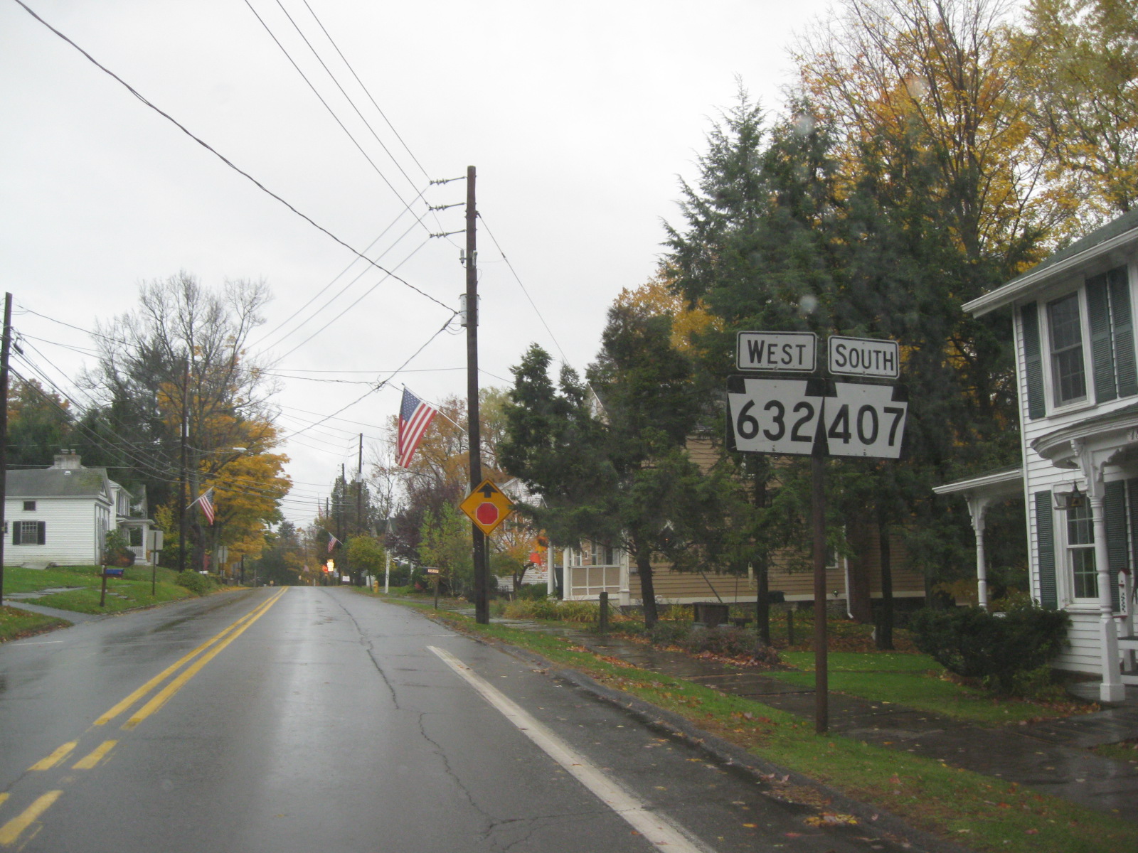
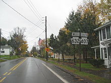 Route 632 and Route 407 heading southbound through downtown Waverly
Route 632 begins at an interchange with U.S. Route 6 and U.S. Route 11 (South Lackawanna Trail) in the borough of Dalton. The highway progresses eastward through Dalton as West Main Street until the intersection with Mill Street, when it changes to East Main Street. Route 632 turns to the southeast and passes along a commercial strip. After Lily Lake Road, the route changes to a residential street and soon leaves Dalton. Outside of Dalton, Route 632 retains the moniker for a short distance, crossing under the former alignment of the Delaware, Lackawanna and Western Railroad. The highway becomes rural, passing a local farm until the intersection with Armstrong and Dean Roads, where the name changes to Clinton Street as the road becomes residential once again. Entering Waverly Township, Route 632 turns eastward, passing the Waverly Elementary School and through a residential strip before intersecting with Route 407 in downtown Waverly. At the intersection with Route 407, Route 632 turns northward along North Abington Road and forms a short concurrency until the intersection with Carbondale Road, where Route 632 forks to the northeast.[2]
Route 632 heads to the northeast after leaving Route 407 and passes through a residential stretch in the northeast parts of Waverly. The route turns eastward then slowly southeastward and after an intersection with Miller Road, Route 632 becomes rural once again. The route passes a large farm and turns to the northeast and winds through rural forests for several miles until it passes a large industrial site and enters the interchange with Exit 197 of Interstate 81. Just after the interchange with Interstate 81, Route 632 passes through residences and intersects with Route 347. After Route 347, Route 632 heads eastward as Waverly Road until intersecting with Scott Road, where the highway turns to the southeast. Along the southeastern stretch, the highway passes numerous residences and a cemetery before entering the hamlet of Green Grove, where Route 632 becomes the primary street, before leaving for a short stretch of rural homes and then into more residences, where the highway intersects with Route 247. At the intersection the Route 632 designation ends as the right-of-way becomes part of Route 247.[2]
Major intersections
The entire route is in Lackawanna County.
Location Mile[1] Destinations Notes Dalton 0.00 US 6 / US 11 (South Lackawanna Trail) / SR 4017 (West Main Street)Western terminus of Route 632. Waverly Township 1.84 PA 407 south (North Abington Road)Southern terminus of concurrency with Route 407. 1.97 PA 407 north (North Abington Road)Northern terminus of concurrency with Route 407. Scott Township 4.83 I-81Exit 197 (Interstate 81) 5.24 PA 3477.96 PA 247Eastern terminus of Route 632. 1.000 mi = 1.609 km; 1.000 km = 0.621 mi References
- ^ a b Yahoo! Inc. Yahoo! Maps – Overview map of Pennsylvania Route 632 (Map). Cartography by NAVTEQ. http://maps.yahoo.com/#mvt=m&lat=41.525231&lon=-75.657173&zoom=13&q1=41.534869%2C-75.738444&q2=41.526548%2C-75.705452&q3=41.528347%2C-75.705023&q4=41.530917%2C-75.653439&q5=41.531495%2C-75.645757&q6=41.521793%2C-75.596791. Retrieved July 5, 2011.
- ^ a b Microsoft. Map of Overview map of Pennsylvania Route 632 – Bing Maps (Map). Cartography by NavTEQ, Inc. http://www.bing.com/maps/#Y3A9NDEuNTI4MzY0Mjk0NTQzOX4tNzUuNjY3NTMzOTE2NjUxMjgmbHZsPTEyJnN0eT1yJnJ0cD1wb3MuNDEuNTM0ODk3OTI5MjgxNTZfLTc1LjczODQ5NzUyNTQ1MzU3X25lYXIlMjBXJTIwTWFpbiUyMFN0JTJDJTIwRGFsdG9uJTJDJTIwUEElMjAxODQxNF9fX2FffnBvcy40MS41MjY2MDA1OTAzMTI4OTZfLTc1LjcwNTU4MTg3Mjg1MjYyX25lYXIlMjA3MDMlMjBDbGludG9uJTIwU3QlMkMlMjBXYXZlcmx5JTJDJTIwUEElMjAxODQ3MV9fX2FffnBvcy40MS41MzE1NjAyMTMxODAyNTZfLTc1LjY0NTgzOTk0NDQ4MThfbmVhciUyMFdhdmVybHklMjBSZCUyQyUyME9seXBoYW50JTJDJTIwUEElMjAxODQ0N19fX2FffnBvcy40MS41MjE4Mjk1NDQ1MTE4Ml8tNzUuNTk2NTcwMzA3ODQ4OTlfX19fYV8mbW9kZT1EJnJ0b3A9MH4wfjB+. Retrieved July 5, 2011.
External links
- Kitsko, Jeffrey J. (2011). "PA 632". Pennsylvania Highways. http://www.pahighways.com/state/PA601-650.html#PA632. Retrieved July 5, 2011.
- Prince, Adam J. (2002). "PA 632". State-Ends.com. http://www.state-ends.com/paends/state/632.html. Retrieved July 5, 2011.
Roads of the Wyoming Valley Interstate Highways Expressways U.S. Routes Pennsylvania Routes Categories:- State highways in Pennsylvania
- Transportation in Lackawanna County, Pennsylvania

Wikimedia Foundation. 2010.