- Pennsylvania Route 106
-
PA Route 106
Route information Maintained by PennDOT Length: 20.69 mi[1] (33 km) Existed: 1972 – present Major junctions West end:  US 11 in Kingsley
 PA 92 in Lenox
 I-81 in Lenox
 PA 374 from Royal to Clifford Township
East end: 
 US 6 Bus. in Carbondale
Location Counties: Susquehanna, Lackawanna Highway system Roads in Pennsylvania
Interstate • US • State • Legislative←  PA 105
PA 107  →
→Pennsylvania Traffic Route 106 (also known as PA 106) is a 20.69-mile (33.30 km) long state highway located in both Susquehanna and Lackawanna counties in Pennsylvania. Route 106 begins at a fork from U.S. Route 11 in the community of Kingsley. The route heads southeasterly for most of its length, interchanging with Interstate 81 in Lenox Township. Route 106 continues into the city of Carbondale, where the designation terminates at U.S. Route 6 Business (North Main Street), the former alignment of U.S. Route 6 through Carbondale.
Route 106 is one of five portions of the original U.S. Route 106, a spur of U.S. Route 6 through Pennsylvania. Route 106 went from U.S. Route 309 in Wyalusing to the New York state line in Damascus Township along current-day Route 652. The designation was eliminated in 1972 and replaced by Route 106 from Kingsley to Carbondale, Route 652 from Indian Orchard to Darbytown and Route 706 from Wyalusing to Nichols.
Contents
Route description
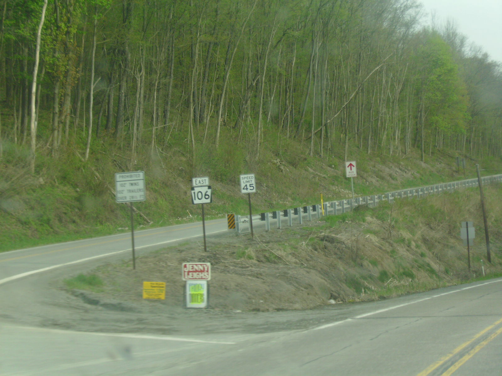
 Route 106 heading from its western terminus at U.S. Route 11 in Kingsley
Susquehanna County
Route 106 begins at an intersection with U.S. Route 11 in the community of Kingsley, Pennsylvania. The route heads to the southeast, paralleling U.S. Route 11 through forestry until the intersection with Jeffers Road, where it turns away from Route 11 and enters fields. The route makes several curves to the southeast and east, crossing through several large fields and industries. The route keeps turning to the southeast, re-entering the deep woods and passing a large pond near West Lenox. In West Lenox, Route 106 passes through forestry and residences until leaving the community for more forestry. After paralleling Creek Road for a distance, Route 106 enters the small community of Lenox, where the highway intersects Route 92 near some industry. A short distance later, the highway interchanges with Interstate 81 at Interchange 211. After Interstate 81, Route 106 continues paralleling the interstate through forestry. The highway continues eastward, paralleling Stone Road into East Lenox, Pennsylvania.[2]
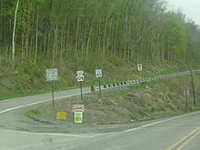
After crossing from East Lenox, Route 106 continues southeastward through fields and soon into a region of residences. The southeastern stretch continues for several miles into the community of West Clifford. There, Route 106 passes some homes and intersects with Route 374. The two designations become concurrent, paralleling the alignment of the Milford and Owego Turnpike Road through West Clifford. Routes 106 and 374 head southward and soon turn southwestward through forestry, until clearing into the community of Royal. In the small community, Routes 106 and 374 fork, with Route 374 heading southwestward to Glenwood and Route 106 heading southeastward through Royal. Route 106 continues further, entering deep woods once again after leaving Royal. At the intersection with Cemetery Road, the highway enters a large cemetery and into Clifford. There, the route crosses through a large residential and commercial community, intersecting with Susquehanna Quadrant Route 2008. The route continues southeastward through the residential area before crossing the county line into Lackawanna County.[2]
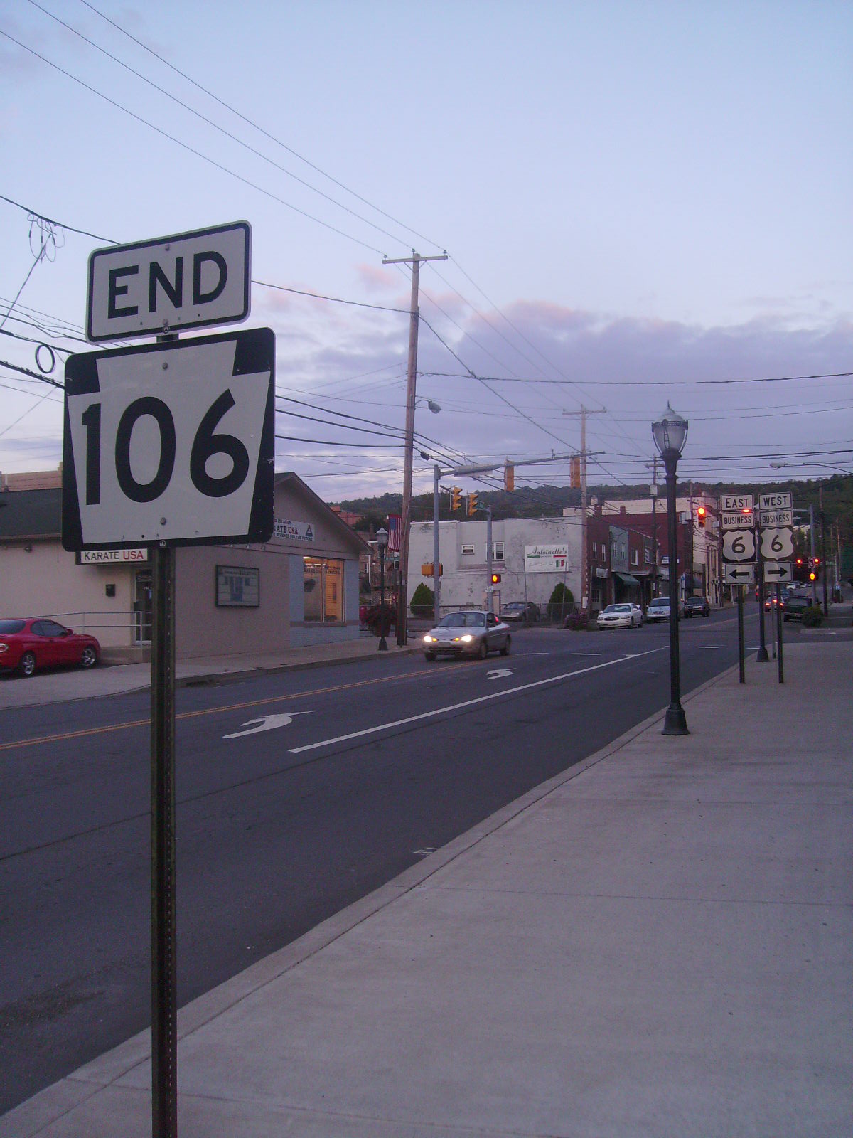
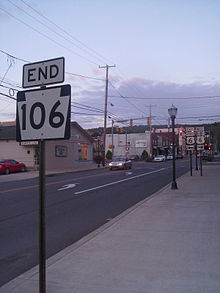 Route 106 at its eastern terminus with U.S. Route 6 Business in Carbondale
Lackawanna County
After crossing into Lackawanna County, Route 106 continues on a southeastern trend, crossing through homes before returning to the deep forestry in Greenfield Township. The route continues further, passing through a lumber yard, where it turns southward and further southeastward into the community of Finch Hill. In Finch Hill, Route 106 passes Our Mother of Sorrows Cemetery and intersects with Route 247 (Lakeland Drive) in the center of the town. After Route 247, Route 106 passes through a small residential district before reaching the Homestead Golf Course. The route passes along the southern side of the golf course and turns eastward after passing to the north of Merli-Sarnoski Park. After leaving the golf course behind, Route 106 makes a gradual turn to the southeast at Crystal Lake Road. There, the highway becomes known as Fall Brook Road, and turns southward through forestry. At the intersection with 43rd Street, Route 106 enters the city of Carbondale. The route, known now as Fallbrook Street, continues on a southeastern trend, entering a large residential district north of the business district. At the intersection with Dundaff Street, it turns southward again, paralleling a nearby river. At the intersection with River Street, Route 106 turns eastward along Salem Avenue, crosses the river and intersects with U.S. Route 6 Business (North Main Street) in Carbondale. At that intersection, the Route 106 designation terminates while Salem Avenue continues as Quadrant Route 1019 through Carbondale.[2]
History
Pennsylvania Route 106 was originally an alignment of Pennsylvania Route 47 designated in 1927.[3] This alignment stretched from U.S. Route 11 in Kingsley to the intersection with U.S. Route 6 in Carbondale. However, this designation was short-lived, and in 1928, the alignment was taken over as the centerpiece to U.S. Route 106, a U.S. Highway which began in the community of Wyalusing, Pennsylvania at U.S. Route 309.[4] The piece that is now PA 106 began in the community of Kingsley and went to the city of Carbondale. The route remained intact for almost 45 years,[5] and in 1972, the U.S. Route 106 designation was decommissioned and replaced by all new designations of Pennsylvania Route 706, PA 106, and Pennsylvania Route 652.[6]
Major intersections
County Location Mile[2] Destinations Notes Susquehanna Kingsley 0.00 US 11Lenox Township 5.65 PA 925.83 I-81Exit 211 (Interstate 81) Clifford Township 9.48 PA 374Northern terminus of concurrency with Route 374 10.76 PA 374Southern terminus of concurrency with Route 374 Lackawanna Greenfield Township 15.87  PA 247 (Lakeland Drive)
Carbondale 20.69
US 6 Bus. (Main Street)1.000 mi = 1.609 km; 1.000 km = 0.621 mi See also
References
- ^ Yahoo Maps (2009). Overview map of PA 106 (Map). Cartography by NAVTEQ Incorporated. http://maps.yahoo.com/#mvt=m&lat=41.755895&lon=-75.746986&zoom=17&q1=41.759633%2C-75.751042&q2=41.57362%2C-75.501811. Retrieved June 10, 2009.
- ^ a b c d Yahoo! Inc. Yahoo! Maps – Overview map of Route 106 with mileposts (Map). Cartography by NAVTEQ. http://maps.yahoo.com/#mvt=h&lat=41.572457&lon=-75.499204&zoom=18&q1=41.760265%2C-75.751407&q2=41.711188%2C-75.673644&q3=41.709844%2C-75.671133&q4=41.68471%2C-75.617983&q5=41.666695%2C-75.616996&q6=41.612621%2C-75.55833&q7=41.573465%2C-75.501682. Retrieved 11 March 2010.
- ^ Pennsylvania Department of Highways (1927). Map Showing Pennsylvania State Highways (Map).
- ^ Pennsylvania Department of Highways (1928). Map Showing Pennsylvania State Highways (Map).
- ^ Pennsylvania Department of Highways (1967). Pennsylvania (Map).
- ^ Pennsylvania Department of Transportation (1972-1973). Pennsylvania State Highway Map (Map).
External links
- Kitsko, Jeffrey J. (2010). "PA 106". Pennsylvania Highways. pp. 101–150. http://www.pahighways.com/state/PA101-150.html#PA106. Retrieved 11 March 2010.
Roads of the Wyoming Valley Interstate Highways Expressways U.S. Routes Pennsylvania Routes Categories:- State highways in Pennsylvania
- U.S. Route 6
- Transportation in Susquehanna County, Pennsylvania
- Transportation in Lackawanna County, Pennsylvania

Wikimedia Foundation. 2010.