- Pennsylvania Route 652
-
PA Route 652
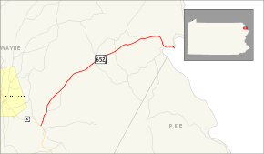
Route information Maintained by PennDOT Length: 10.57 mi[2] (17.01 km) Existed: 1972[1] – present Major junctions West end:  US 6 in Indian Orchard
East end:  NY 52/Sullivan CR 24 in Darbytown
Location Counties: Wayne Highway system Roads in Pennsylvania
Interstate • US • State • Legislative←  PA 651
PA 653  →
→Pennsylvania Route 652, designated by the Pennsylvania Department of Transportation (PennDOT) as State Route 0652, is a 10.57-mile (17.01 km) long east–west state highway located in the northeast Pennsylvania county of Wayne. The western terminus of the route is at U.S. Route 6 in the Texas Township community of Indian Orchard. The highways heads to the northeast, and reaches the eastern terminus at the New York-Pennsylvania border in Damascus Township, where Route 652 crosses the Narrowsburg–Darbytown Bridge over the Delaware River and into New York, continuing as New York State Route 52 and Sullivan County Route 24.
The highway originated as the easternmost stretch of United States Route 106 when the United States Highway System was first put together in 1926. The route, however, was assigned as a state highway in 1920. Route 652 was once used south of the alignment, in the northern suburbs in Philadelphia. Route 652 remained on that alignment until 1946, and in 1972, the 652 designation was reassigned onto the U.S. Route 106 alignment.
Contents
Route description
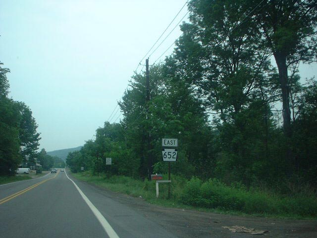
 The western terminus of Pennsylvania State Route 652 in Indian Orchard
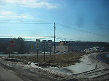
Route 652, better known as the Beach Lake Highway, begins at a three segment intersection with U.S. Route 6 (the Grand Army of the Republic Highway) in the small community of Indian Orchard, Pennsylvania. At the southern terminus, there are several commercial buildings that serve the local residents. Route 652 heads to the northeast, passing through a short patch of woods in the area of Indian Orchard. There is a short clearing, serving some residential homes and intersected with an unnamed local road, where it leaves Indian Orchard.[2]
Route 652 continues to the northeast out of Indian Orchard, where the surroundings of the highway became more open, with residential homes and fields surrounding the highway. The next few intersections are with local driveways, which serve the local residential homes. After a few driveways, Route 652 enters the community of Bethel. There, the highway becomes more developed, and the highway begins to pass more commercial developments. There, Route 652 intersects with Navajo Road, a local road which parallels the northbound highway. After an intersection with a local unnamed road, Route 652 leaves Bethel.[2]
 Route 652 eastbound reassurrance shield
After leaving Bethel, Route 652 continues its way northward, entering a deep patch of woodlands and paralleling to the east of Navajo Road, which intersected earlier. The deep patch continues, until there is a clearing for a commercial building, and after some more trees, the patch breaks up at Volunteer Road, a dead-end driveway. Route 652 continues now to the northeast, passing some local roads and intersecting with Gassen Road, a local highway in Berlin Township. After Gassen Road, the surroundings of the highway become highly developed, and after a short distance, intersects with another local road.[2]
Route 652 begins a northeastern progression, where it passes to the south of several ponds and several local residences. There are some short patches of the woodlands in the area. At an intersection with Dunn Road and Buckingham Road, Route 652 passes some local residences, and eventually becomes less developed with fields surrounding the highway in Berlin Township. At the intersection with Bayly Road, Route 652 turns on a short eastern progression and into the center of Berlin Township, where the highway becomes moderately developed, passing fields and homes. At an intersection with Trails Road, Route 652 turns to the northeast, leaving Berlin Township for Beach Lake, Pennsylvania.[2]
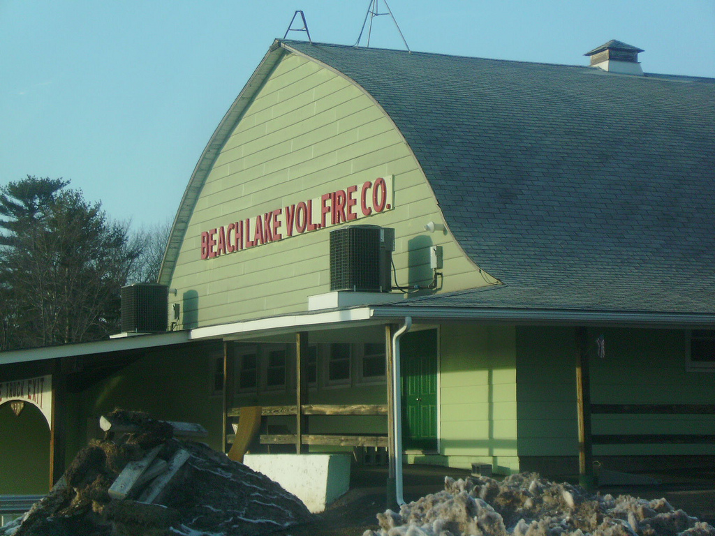
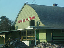 The Beach Lake Fire Company, a large building along PA 652 southbound in Beach Lake
Upon entering Beach Lake, the highway enters a short patch of forests, intersecting with a local road, Rosencraft Road, and an unnamed dead-end loop road. There, Route 652 becomes highly developed, passing several residences on both the northern and southern sides of the highway. Nearby the highway is Beach Lake, the body of water for which the community is named. At an intersection with Milanville, which forks off to the north, Route 652 passes to the east of the Beach Lake Volunteer Fire Department.[2]
There, in Beach Lake, Route 652 passes a more highly developed commercial region. After an intersection with Church Road, the highway begins a northeast progression, and leaves Beach Lake. Route 652 becomes less developed once again outside of Beach Lake, intersecting with Perkins Pond Road, crossing over a small creek in the area. After a process of a few hundred feet, the highway passes to the south of a small pond. At Perkins Pond Road, Route 652 turns to the northeast, the highway becomes known as the Beach Lake Highway on maps. The route becomes developed, passing a short set of development. At an intersection with Little Beach Lake Road, where Route 652 turns to the east and into Damascus Township.[2]
In Damascus Township, Route 652 continues through a moderate stretch of development and at an intersection with Trot Lane Road, the highway turns to the northeast once again. After the intersection, Route 652 passes a pond in the area of Darbytown to the south, intersecting with Clemen U Miller Road, and at Bavarian Hill Road, Route 652 continues to the east, running along the community line of Darbytown and Atco.[2]
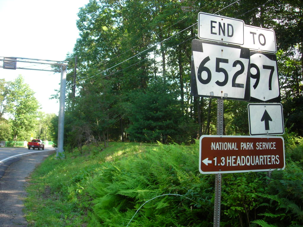
 Eastern terminus of Pennsylvania Route 652
In Atco and Darbytown, the highway is highly surrounded by the dense woodlans in the area. At Atco Road, Route 652 makes a dive to the south from its the rest of alignment, parallelling Plank Road to the east. Eventually, the highway leaves Atco and continues into downtown Darbytown, where the highway intersects with Peggy Runway Road, which heads southward along the Delaware River. There, the highway parallels the Delaware River and heading eastward. At an intersection with State Route 1017, Route 652 dips to the southeast and crosses the Narrowsburg-Darbytown Bridge and continued into New York as New York State Route 52 and Sullivan County Route 24.[2]
History
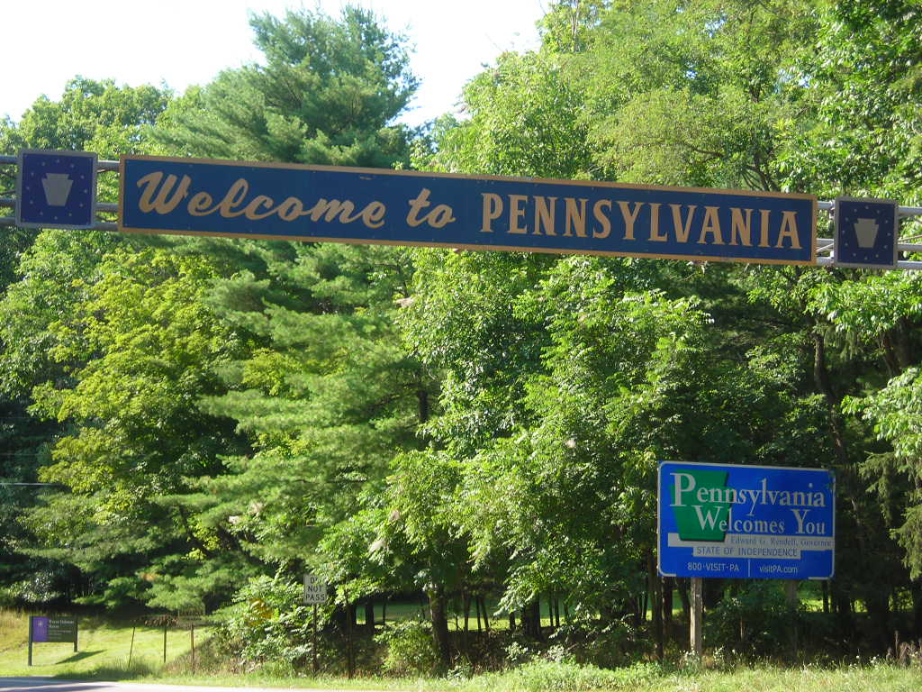
 Entering Pennsylvania on Route 652/NY 52. The newer style of sign is visible nearby
PA 652 was first assigned in 1928 to a series of local streets in the northwestern suburbs of Philadelphia. The southern terminus of the route was at the modern U.S. Route 30/Old Eagle School Road intersection on the Chester–Delaware county line near Devon to the west and Wayne to the east. PA 652 followed Old Eagle School Road north to King of Prussia, where the route turned east onto East Swedesford Road. At the location of the modern U.S. Route 422/U.S. Route 202 interchange, PA 652 turned north onto Guthrie Road, running alongside the right-of-way of what is now the US 422 expressway to North Gulph Road. PA 652 continued north on North Gulph Road to the Valley Forge National Historical Park, where it terminated at Pennsylvania Route 23.[3][4]
In 1946, PA 652 was transferred to the control of the local suburbs along its entire length, and control of the roads went to local highway departments.[5][6] The portion of the route between Guthrie Road and PA 23 returned to state control in 1967 when Pennsylvania Route 363 was routed onto North Gulph Road.[7]
The current alignment of Route 652 was classified as a state highway as early as 1920,[8] nine years after the Sproul Road Bill was passed by the Pennsylvania State Legislature. The Sproul Road Bill also assigned the first state highways in Pennsylvania.[9] There was no designation given to the highway.[10] From 1926 to 1972, the modern routing of PA 652 was part of U.S. Route 106.[11] The road also carried a portion of Pennsylvania Route 19 from 1927 to 1930.[12][13] In 1972, US 106 was decommissioned and replaced with the PA 652 designation between Indian Orchard and the Delaware River.[1][14][15]
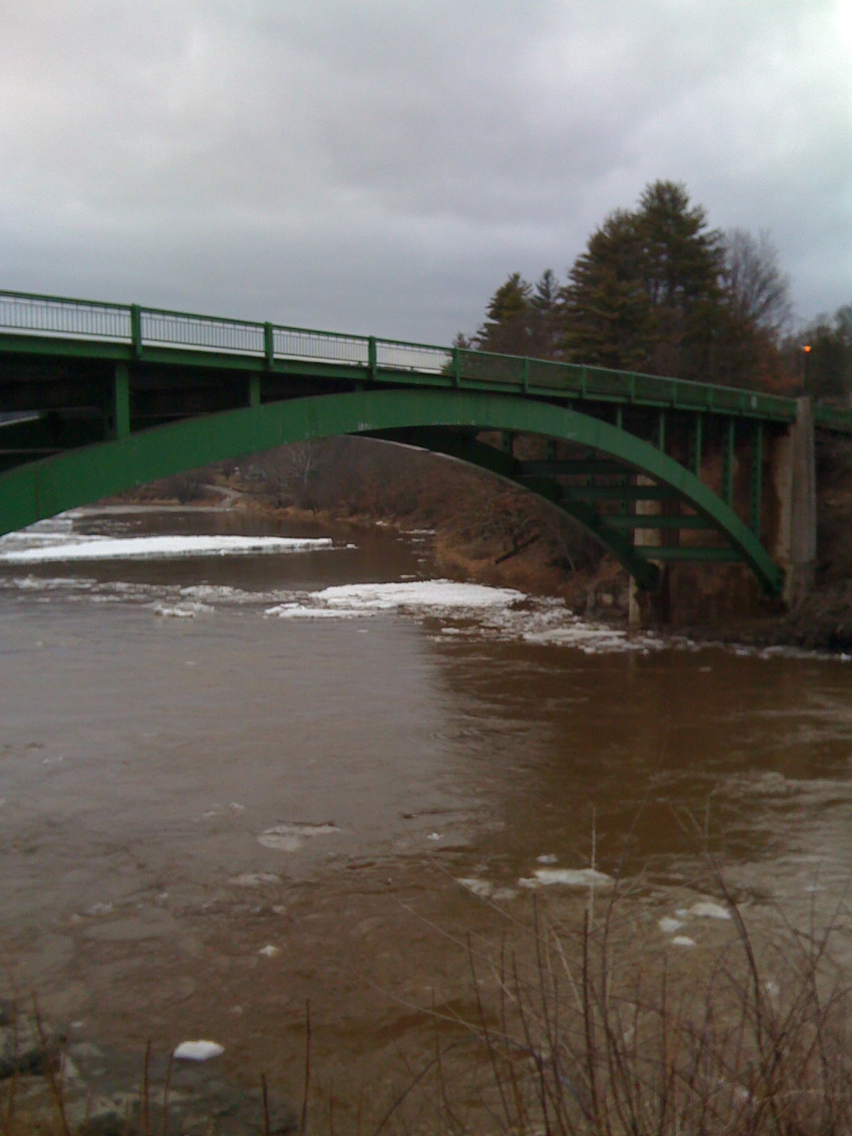
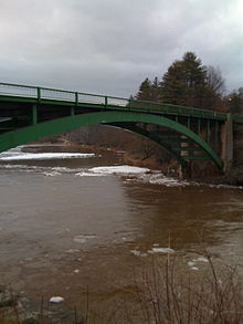 The Narrowsburg–Darbytown Bridge over the Delaware River. The state line is about mid-span, serving as PA 652's northern terminus
Route 652 has a consistent stretch of water crossings that helps put the highway together. The first bridge along the highway, built in 1925, was the U.S. Route 106 bridge spanning a tributary of the Delaware River. The concrete-paved span was reconstructed in 1980 and crosses the tributary into New York on a 50.85 feet (15.50 m) long span.[16] The next bridge was the current Narrowsburg–Darbytown Bridge, built in 1954 over the Delaware. The bridge is structurally deficient according to the United States Department of Transportation, and is in need of replacement. The bridge is 425 feet (130 m) long and made of steel.[17]
The final two bridges were constructed in 1964. The first was constructed for Route 106 over Indian Orchard Brook. It is located about 500 feet (150 m) east of State Route 2011 (Poor Farm Road). It is a structurally deficient, 20.99 feet (6.40 m) concrete bridge. There is no recorded estimate for replacement costs.[18] The second bridge is also over Indian Orchard Brook, and is in Texas Township. The bridge is 41.99 feet (12.80 m) long and built out of concrete, which handles an average of 6,804 commuters a year.[19]
Major intersections
The entire route is in Wayne County.
Location Mile[2][20] Destinations Notes Indian Orchard 0.00 US 6Bethel 0.84 Poor Farm Road (SR 2011) Beach Lake 5.09 SR 1011 Begin/end concurrency with SR 1011 5.62 SR 1011 Begin/end concurrency with SR 1011 6.52 Perkins Pond Road (SR 1013) Atco 8.94 Lassus Road (SR 1008) Darbytown 10.54 SR 1017 10.57 NY 52Narrowsburg–Darbytown Bridge over the Delaware River. 1.000 mi = 1.609 km; 1.000 km = 0.621 mi References
- ^ a b Pennsylvania Department of Transportation (1972-1973). Pennsylvania State Highway Map (Map).
- ^ a b c d e f g h i j Yahoo! Inc. Yahoo! Maps – overview map of Pennsylvania Route 652 (Map). Cartography by NAVTEQ. http://maps.yahoo.com/#mvt=m&lat=41.613582&lon=-75.084953&zoom=14&q1=41.546617%2C-75.213528&q2=41.609667%2C-75.061951. Retrieved 2008-09-29.
- ^ Pennsylvania Department of Highways (1928). Map Showing Pennsylvania State Highways (Map).
- ^ Automobile Blue Book. Harvard University. 1918. pp. 768. http://books.google.com/?id=LNgNAAAAYAAJ&pg=PA768&dq=Pennsylvania+Route+652. Retrieved 2009-01-11.
- ^ Pennsylvania Department of Highways (1946). Pennsylvania Official Road Map (Map).
- ^ Pennsylvania Department of Highways (1947). Pennsylvania Official Road Map (Map).
- ^ Pennsylvania Department of Highways (1967). Pennsylvania (Map).
- ^ A. Hoen & Co. (1920). Map of Pennsylvania State Highways (Map). Cartography by A. Hoen & Co..
- ^ Of Agriculture, Pennsylvania. Dept (1914). "Road Construction". Annual report of the Pennsylvania Department of Agriculture (1914 ed.). Pennsylvania Department of Agriculture. pp. 262. http://books.google.com/?id=jAgTAAAAYAAJ&pg=PA262&lpg=PA262&dq=Sproul+Road+Bill+1911. Retrieved March 27, 2009.
- ^ Benedict & Strum (1911-1912). Pennsylvania State Highways (Map). Cartography by Benedict & Strum.
- ^ United States Department of Transportation (1926). Overview map of all proposed U.S. Routes (Map). Cartography by United States Department of Transportation. http://www.okladot.state.ok.us/hqdiv/p-r-div/maps/misc-maps/1926us.pdf. Retrieved April 12, 2009.
- ^ Pennsylvania Department of Highways (1927). Map Showing Pennsylvania State Highways (Map).
- ^ Pennsylvania Department of Highways (1930). Map Showing Pennsylvania State Highways (Map).
- ^ Kitsko, Jeffrey J. (2009). "U.S. Route 106 (Decommissioned)". Pennsylvania Highways. pp. 1. http://www.pahighways.com/us/decommissioned/US106.html. Retrieved 2009-04-09.
- ^ *Kitsko, Jeffrey J. (2009). "PA 652". Pennsylvania Highways. pp. 651–700. http://www.pahighways.com/state/PA651-700.html#PA652. Retrieved 2009-04-09.
- ^ National Bridge Inventory (2007). "Structure #630652023002190". United States Department of Transportation. pp. 1. http://nationalbridges.com/nbi_record.php?StateCode=42&struct=630652023002190. Retrieved 2009-02-15.
- ^ National Bridge Inventory (2007). "Structure #630652025018440". United States Department of Transportation. pp. 1. http://nationalbridges.com/nbi_record.php?StateCode=42&struct=630652025018440. Retrieved 2009-02-15.
- ^ National Bridge Inventory (2007). "Structure #630652004000000". United States Department of Transportation. pp. 1. http://nationalbridges.com/nbi_record.php?StateCode=42&struct=630652004000000. Retrieved 2009-02-15.
- ^ National Bridge Inventory (2007). "Structure #630652002000000". United States Department of Transportation. pp. 1. http://nationalbridges.com/nbi_record.php?StateCode=42&struct=630652002000000. Retrieved 2009-02-15.
- ^ Yahoo! Inc. Yahoo! Maps – overview of intersections on PA 652 (Map). Cartography by NAVTEQ. http://maps.yahoo.com/#mvt=m&lat=41.610715&lon=-75.066786&zoom=16&q1=41.547297%2C-75.213084&q2=41.558184%2C-75.206776&q3=41.598954%2C-75.151415&q4=41.601843%2C-75.142317&q5=41.608036%2C-75.127769&q6=41.619555%2C-75.08524&q7=41.61025%2C-75.062194. Retrieved 2009-03-24.
Categories:- State highways in Pennsylvania
- Transportation in Wayne County, Pennsylvania


Wikimedia Foundation. 2010.