- Pennsylvania Route 363
-
PA Route 363
Route information Maintained by PennDOT Length: 11.86 mi[2] (19.09 km) Existed: by 1930[1] – present Major junctions South end:  US 422 in Audubon
North end:  PA 63 in Lansdale
Location Counties: Montgomery Highway system Roads in Pennsylvania
Interstate • US • State • Legislative←  PA 362
PA 364  →
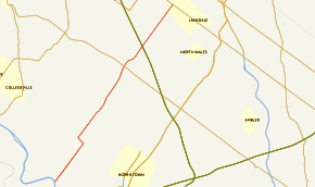
→Pennsylvania Route 363 (PA 363) is a state highway located in Montgomery County, Pennsylvania that is a spur of PA 63. The route runs 11.86 mi (19.09 km) from an interchange with U.S. Route 422 (US 422) near Valley Forge northeast to PA 63 in Lansdale. The route runs through suburban areas of central Montgomery County, passing some farmland in Worcester Township. PA 363 is designated along Trooper Road, Ridge Pike, Park Avenue, and Valley Forge Road. In the community of Worcester, the route crosses PA 73.
PA 363 was first designated by the Pennsylvania Department of Highways around 1930 to run from PA 23 in Port Kennedy to PA 63 in Lansdale. Between the 1940s and the 1960s, PA 363 extended west on present-day PA 23 to end near Valley Forge. In the 1960s, the route was redirected to follow Gulph Road to US 202 in King of Prussia. By 1989, the south end of PA 363 was relocated to the US 422 interchange. The Betzwood Bridge, which had carried PA 363 over the Schuylkill River, was removed in the 1990s but is expected to be rebuilt.
Contents
Route description
 PA 363 at intersection with Germantown Pike in Worcester Township
PA 363 begins at an interchange with US 422 (Pottstown Freeway) near Valley Forge National Historic Park in Montgomery County. From this point, the route heads northeast on four-lane divided Trooper Road, forming the border between Lower Providence Township to the northwest and West Norriton Township to the southeast. The road passes a business park to the northwest and residential neighborhoods to the southeast as it narrows into an undivided road and enters areas of shopping centers. Here, the route becomes a divided highway again and intersects Egypt Road.[3][4]
PA 363 continues as a two-lane undivided road past more homes as it continues to the Ridge Pike intersection. At this point, the route turns northwest onto Ridge Pike and fully enters Lower Providence Township, passing businesses as a three-lane road with a center left-turn lane. PA 363 turns northeast onto two-lane Park Avenue and runs through more residential areas. A short distance after crossing into Worcester Township, the route comes to the community of Fairview Village and crosses Germantown Pike in commercial areas.[3][4]
Upon crossing Germantown Pike, PA 363 becomes known as Valley Forge Road and continues into agricultural areas with scattered residential neighborhoods. The amount of development increases until the road comes to the junction with PA 73 (Skippack Pike) in the community of Worcester. After the PA 73 intersection, PA 363 continues past areas of housing developments to the west and farmland to the east before it reaches Morris Road. At this point, the route becomes the border between Towamencin Township to the northwest and Upper Gwynedd Township to the southeast, crossing under I-476 (Pennsylvania Turnpike Northeast Extension) along this stretch.[3][4]
The road passes through residential neighborhoods before entering commercial areas and crossing Sumneytown Pike. PA 363 runs past a mix of homes and businesses as it gains a center left-turn lane on the approach to the Allentown Road junction. A short distance later, the route enters Lansdale and passes homes as a two-lane road. PA 363 reaches its northern terminus at an intersection with PA 63 in Lansdale.[3][4]
History
When Pennsylvania first legislated routes in 1911, present-day PA 363 was not given a number with the exception of the Ridge Pike portion, which was designated as part of Legislative Route 146.[5] By 1930, PA 363 was designated to run between PA 23 in the Port Kennedy section of Upper Merion Township and PA 63 in Lansdale, heading north across the Schuylkill River near the present US 422 bridge, before picking up Trooper Road and following its current alignment north to Lansdale. Along Ridge Pike, PA 363 shared a concurrency with US 422. At this time, the entire length of the route was paved.[1]
By 1945, PA 363 was extended west to end at PA 23 a short distance to the east of the community of Valley Forge.[6] This portion of route was cosigned with PA 23 Truck by 1950.[7][8] PA 363 was rerouted to follow Gulph Road from Port Kennedy to US 202 in King of Prussia, with PA 23 being rerouted to follow the former PA 363 between Valley Forge and Port Kennedy, by 1967. Also by this time, the US 422 concurrency on Ridge Pike had been removed and a freeway had been built that connected PA 363 a short distance north of the Schuylkill River to the US 202 freeway on the border of Chester and Montgomery counties.[9]
By 1989, the southern terminus of PA 363 was cut back to its current location at the US 422 interchange.[10] In 1991, the Betzwood Bridge, which had carried PA 363 over the Schuylkill River, was closed because of structural issues.[11] The bridge was removed in 1995 and limited bicycle and pedestrian access to Valley Forge Park from the north, with a temporary bike path being erected on the parallel US 422 bridge.[12] Construction on a new bridge at this site is planned to begin in 2012.[13] This new bridge is planned to be for bicycles and pedestrians only and will provide better access to Valley Forge Park.[12] In addition, improvements to the interchange between PA 363 and US 422, which will add a ramp from PA 363 to westbound US 422, is expected to start in 2012.[13]
Major intersections
The entire route is in Montgomery County.
Location Mile[2] Destinations Notes Lower Providence Township 0.00 US 422 (Pottstown Expressway)Interchange Worcester Township 7.58  PA 73 (Skippack Pike)
Lansdale 11.86 PA 63 (West Main Street)1.000 mi = 1.609 km; 1.000 km = 0.621 mi References
- ^ a b Pennsylvania Department of Highways (1930). Tourist Map of Pennsylvania (Map). ftp://ftp.dot.state.pa.us/public/pdf/BPR_pdf_files/Maps/Statewide/Historic_OTMs/1930fr.pdf. Retrieved January 27, 2011.
- ^ a b Delorme Street Atlas USA 2007, Toggle Measure Tool
- ^ a b c d ADC Map (2006). Montgomery County, Pennsylvania (Map). 1"=2000' (18th ed.). ISBN 0-87530-775-2.
- ^ a b c d Google, Inc. Google Maps – overview of Pennsylvania Route 363 (Map). Cartography by Google, Inc. http://maps.google.com/maps?f=d&source=s_d&saddr=40.11317,+-75.41937&daddr=pa+63+and+pa+363&hl=en&geocode=FRIUZAIdFjGB-w%3BFUEkZgIdJxaD-ynjtsM3LaLGiTGgUa7ylKNFwg&mra=ls&sll=40.114364,-75.418053&sspn=0.007483,0.021136&ie=UTF8&t=h&z=11. Retrieved January 27, 2011.
- ^ Pennsylvania Department of Highways (1911). Map of Pennsylvania Showing State Highways (Map). ftp://ftp.dot.state.pa.us/public/pdf/BPR_pdf_files/Maps/Statewide/Historic_OTMs/1911.pdf. Retrieved January 27, 2011.
- ^ Pennsylvania Department of Highways (1945). Montgomery County (Map) (Sheet 2 ed.). ftp://ftp.dot.state.pa.us/public/pdf/BPR_PDF_FILES/Maps/Type_10_GHS_Historical_Scans/Montgomery_1945_Sheet_2.pdf. Retrieved January 27, 2011.
- ^ Pennsylvania Department of Highways (1950). Official Road Map of Pennsylvania (Map). ftp://ftp.dot.state.pa.us/public/pdf/BPR_pdf_files/Maps/Statewide/Historic_OTMs/1950fr.pdf. Retrieved January 27, 2011.
- ^ Pennsylvania Department of Highways (1950). Montgomery County (Map) (Sheet 1 ed.). ftp://ftp.dot.state.pa.us/public/pdf/BPR_PDF_FILES/Maps/Type_10_GHS_Historical_Scans/Montgomery_1950_Sheet_1.pdf. Retrieved May 21, 2007.
- ^ PennDOT (1967). Montgomery County (Map) (Sheet 1 ed.). ftp://ftp.dot.state.pa.us/public/pdf/BPR_PDF_FILES/Maps/Type_10_GHS_Historical_Scans/Montgomery_1967_Sheet_1.pdf. Retrieved January 27, 2011.
- ^ Pennsylvania Department of Transportation (1989). Pennsylvania Official Transportation Map (Map). ftp://ftp.dot.state.pa.us/public/pdf/BPR_pdf_files/Maps/Statewide/Historic_OTMs/1989fr.pdf. Retrieved January 27, 2011.
- ^ Goodman, Rhonda (April 7, 1994). "Wheels Are Turning On Bike Trail Project". The Philadelphia Inquirer. http://articles.philly.com/1994-04-07/news/25863390_1_penndot-bicycle-lane-path. Retrieved February 3, 2011.
- ^ a b "Old Betzwood Bicycle/Pedestrian Trail Project". Boles, Smyth Associates, Inc.. http://www.422improvements.com/News/images/PDFs/public-open-house-scheduled-for-betzwood-bridge-replacement.pdf. Retrieved February 3, 2011.
- ^ a b "Projects - 422 Improvements". GVF Transportation. http://www.422improvements.com/422-improvements/projects.aspx. Retrieved January 27, 2011.
External links
Road transportation infrastructure of the metro Philadelphia area Interstates U.S. Routes Pennsylvania Routes New Jersey Routes Delaware Routes Named roads/streets Benjamin Franklin Parkway · Broad Street · City Avenue · Front Street · Girard Avenue · Market Street · Roosevelt Boulevard · South Street · Chestnut Street · Walnut Street
Pennsylvania Turnpike · New Jersey Turnpike · Delaware Turnpike · Atlantic City Expressway · Schuylkill Expressway · Delaware Expressway · Blue Route · Vine St Expressway · North South Freeway · Lancaster Avenue · Bethlehem Pike · Baltimore Pike · Black Horse PikeBridges Delaware Memorial Bridge · Commodore Barry Bridge · Walt Whitman Bridge · Ben Franklin Bridge · Betsy Ross Bridge · Tacony–Palmyra Bridge · Burlington–Bristol Bridge · Delaware River – Turnpike Toll BridgeCategories:- State highways in Pennsylvania


Wikimedia Foundation. 2010.