- Pennsylvania Route 348
-
PA Route 348
Route information Maintained by PennDOT Length: 7.13 mi[1] (11.47 km) Existed: 1936 – present Major junctions West end:  PA 435 near Elmhurst
 PA 247 in Elmhurst
East end:  PA 590 near Hollisterville
Location Counties: Lackawanna, Wayne Highway system Roads in Pennsylvania
Interstate • US • State • Legislative←  PA 347
PA 349  →
→Pennsylvania Route 348 (designated by the Pennsylvania Department of Transportation as SR 348) is a 7.13-mile (11.47 km) long state highway located in Lackawanna and Wayne counties in Pennsylvania. The western terminus is at Route 435 near Elmhurst. The eastern terminus is at Route 590 near Hollisterville.
Contents
Route description
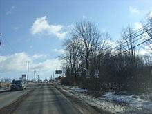 Route 348 approaching its eastern terminus north of the hamlet of Hollisterville at Route 590
Route 348 begins at an intersection with the southbound lanes of the divided Route 435 in Elmhurst, Pennsylvania. The route progresses northeastward as the Luzerne and Wayne County Pike through woodlands just north of Interstate 84. The two-lane road parallels the nearby interstate into a small residential area along the north side of the highway. Route 348 enters downtown Elmhurst and becomes a frontage road to Interstate 84. Both roads make a curve to the east and enter downtown Mount Cobb, Pennsylvania, a neighborhood of Elmhurst.[2]
Through Mount Cobb, Route 348 intersects with Route 247 and changes names to Mount Cobb Road. Crossing through several local residences and businesses, Route 348 curves eastward out of Mount Cobb, following a stretch of residences into the hamlet of Elmdale. In Elmdale, the route crosses over Wallenpaupack Creek and turns to the southeast. After an intersection with Old Mill Road, Route 348 crosses from Lackawanna County into Wayne County and changes names to the Mount Cobb Highway. A short distance over the county line, Route 348 passes north of the hamlet of Hollisterville and ends at a merge with Route 590, which continues on the right-of-way as the Hamlin Highway.[2]
Major intersections
County Location Mile[1] Destinations Notes Lackawanna Elmhurst Township 0.00 PA 435 southWestern terminus of Route 348. 2.97 PA 247Wayne Salem Township 7.13 PA 590 (Hamlin Highway)Eastern terminus of Route 348. Hamlet of Hollisterville. 1.000 mi = 1.609 km; 1.000 km = 0.621 mi References
- ^ a b Yahoo! Inc. Yahoo! Maps – Overview map of Pennsylvania Route 348 (Map). Cartography by NAVTEQ. http://maps.yahoo.com/#mvt=m&lat=41.412425&lon=-75.500244&zoom=13&q1=41.391026%2C-75.553127&q2=41.40981%2C-75.504718&q3=41.4047%2C-75.428833. Retrieved July 1, 2011.
- ^ a b Microsoft. Map of Overview map of Pennsylvania State Route 348 – Bing Maps (Map). Cartography by NavTEQ, Inc. http://www.bing.com/maps/#Y3A9cXd5cm44OHEzcmtuJmx2bD0xNyZzdHk9YiZydHA9cG9zLjQxLjM5MTAwNTAxMjM3MDI5Xy03NS41NTMxMzg2NjEzNzY5M19fX19hX35wb3MuNDEuNDA5ODU4ODY4NTAwOTdfLTc1LjUwNDk0MjgzNDM3NzI1X25lYXIlMjAxMTk5JTIwTW91bnQlMjBDb2JiJTIwUmQlMkMlMjBKZWZmZXJzb24lMjBUb3duc2hpcCUyQyUyMFBBJTIwMTg0MzYtMzMwMF9fX2FffnBvcy40MS40MDUwMDg0MTUwNjg3MzVfLTc1LjQyODA3MDI2NzM4ODgzX25lYXIlMjAyMzclMjBNb3VudCUyMENvYmIlMjBId3klMkMlMjBMYWtlJTIwQXJpZWwlMkMlMjBQQSUyMDE4NDM2X19fYV8mbW9kZT1EJnJ0b3A9MH4wfjB+. Retrieved July 1, 2011.
External links
- Kitsko, Jeffrey J. (2011). "PA 348". Pennsylvania Highways. http://www.pahighways.com/state/PA301-350.html#PA348. Retrieved July 1, 2011.
- Prince, Adam J. (2002). "PA 348". State-Ends.com. http://www.state-ends.com/paends/state/348.html. Retrieved July 1, 2011.
Roads of the Wyoming Valley Interstate Highways Expressways U.S. Routes Pennsylvania Routes Categories:- State highways in Pennsylvania
- Transportation in Lackawanna County, Pennsylvania
- Transportation in Wayne County, Pennsylvania


Wikimedia Foundation. 2010.