- Pennsylvania Route 435
-
PA Route 435
Route information Maintained by PennDOT Length: 14.44 mi[1] (23.24 km) Existed: 1972 – present Major junctions South end:  PA 507 near Gouldsboro
 PA 307 in Covington Township
 PA 502 in Covington Township
 PA 690 in Moscow
 PA 590 in Elmhurst Township
 PA 348 in Elmhurst Township
North end: 
 I-84 / I-380 in Dunmore
Location Counties: Monroe, Wayne, Lackawanna Highway system Roads in Pennsylvania
Interstate • US • State • Legislative←  PA 434
PA 436  →
→Pennsylvania Route 435 (designated by the Pennsylvania Department of Transportation as SR 435) is a 14.44-mile (23.24 km) long state highway located in Monroe, Wayne, and Lackawanna counties in Pennsylvania. The southern terminus is at PA 507 near Gouldsboro. The northern terminus is at Interstate 84 and Interstate 380 in Dunmore. The highway used to be part of U.S. Route 611 before the route was decommissioned.
Contents
Route description
Route 435 begins at a junction with Route 507 at the northwestern corner of Gouldsboro State Park in Monroe County. This junction takes place just east of the western terminus for Route 507 at Interstate 380's Exit 13. Route 435 heads northwestward out of Monroe County straight into Wayne County, paralleling a distance from Interstate 380 through the rural stretches of Clifton Township. The highway continues north as a two-lane road through Clifton, passing west of Big Bass Lake and soon the Covington Industrial Park. Route 435 continues a close parallel with the interstate as it passes east of Covington Lake and enters Covington Township in now Lackawanna County. Just north of the county line, Route 435 forks to the northeast at a junction with Route 307 (the Scranton-Pocono Highway).[2]
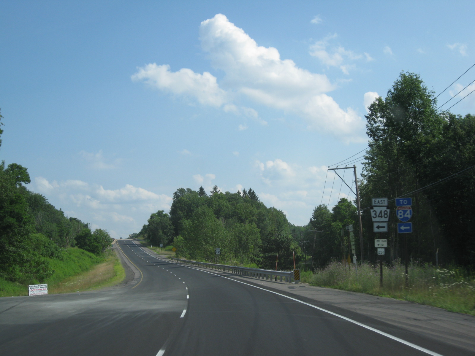
 Route 435 southbound in Elmhurst Township at the junction with Route 348
Route 435 continues to the northeast through the residential regions of Covington Township, passing into the small hamlet of Daleville. Through Daleville, the route remains residential, and enters the commercial hamlet and an intersection with Route 502 (Daleville Highway). Route 435 continues northward out of Daleville, beginning a parallel with the former Delaware, Lackawanna and Western Railroad main line past the Saint Catherine's Cemetery and soon into the borough of Moscow. Heading through Moscow, Route 435 gains the moniker of South Main Street, and makes a large curve along the railroad line to an intersection with Route 690 (New Street). Here, Route 435 and Route 690 begin a concurrency through downtown Moscow, passing the local train station and at the intersection with Church Street, Route 690 turns west onto Church while Route 435 continues north along North Main Street.[2]
Leaving downtown Moscow, Route 435 continues northward aside the Lackawanna Railroad main line. The forestry soon takes over and residences become sporadic as the route winds its way through Elmhurst Township. The rail line moves to the east a bit as both the railroad and Route 435 pass the Elmhurst Reservoir. Passing Fairview Memorial Park, Blue Shutters Road (Quadrant Route 2010) soon merges in. After the reservoir ends, Route 435 crosses under the curving rail line and continues northward into the hamlet of Elmhurst. Through Elmhurst, Route 435 begins a parallel with Route 590, which soon merges in with the main route. Route 435 now continues northwestward out of Elmhurst, crossing under Interstate 84. After this, Route 435 becomes a divided highway with two lanes in each direction. Immediately after the division, Route 348 merges into the highway. The highway winds along the Roaring Brook into Dunmore, following the Drinker Turnpike until it forks. Route 435 soon turns to the northwest once again and merges into Exit 2 on the now-concurrent Interstate 84 and Interstate 380 in Dunmore.[2]
Major intersections
County Location Mile[1] Destinations Notes Monroe Gouldsboro State Park 0.00 PA 507Southern terminus of Route 435. Lackawanna Covington Township 3.89 PA 307 (Scranton-Pocono Highway)Southern terminus of Route 307. 5.51 PA 502 (Daleville Highway)Western terminus of Route 502. Moscow 7.52 PA 690 east (New Street)Southern terminus of concurrency with Route 690. 7.65 PA 690 west (Church Street)Northern terminus of concurrency with Route 690. Elmhurst Township 11.18 PA 590Western terminus of Route 590. 11.95 PA 348Western terminus of Route 348. Dunmore 14.44 I-84 / I-380Northern terminus of Route 435. 1.000 mi = 1.609 km; 1.000 km = 0.621 mi References
- ^ a b Yahoo! Inc. Yahoo! Maps – Overview map of Pennsylvania Route 435 (Map). Cartography by NAVTEQ. http://maps.yahoo.com/#mvt=m&lat=41.315263&lon=-75.477189&zoom=12&q1=41.232048%2C-75.496415&q2=41.285795%2C-75.511007&q3=41.307591%2C-75.514097&q4=41.335244%2C-75.517787&q5=41.337049%2C-75.51856&q6=41.381694%2C-75.547485&q7=41.391997%2C-75.552935&q8=41.400496%2C-75.583061. Retrieved May 14, 2011.
- ^ a b c Microsoft. Map of Overview map of Pennsylvania Route 435 – Bing Maps (Map). Cartography by NavTEQ, Inc. http://www.bing.com/maps/#Y3A9cXc1MDJrOHE3eDFxJmx2bD0xNyZzdHk9YiZydHA9cG9zLjQxLjIzMTk4MTM3ODc5ODk1Xy03NS40OTYwOTUwMzMwNjU3OV9fX19hX35wb3MuNDEuMzM1MzA2NTAwMDA3ODdfLTc1LjUxNjkzMDE4MjU2Njg4X25lYXIlMjAyNjklMjBTJTIwTWFpbiUyMFN0JTJDJTIwTW9zY293JTJDJTIwUEElMjAxODQ0NC05MDM4X19fYV9+cG9zLjQxLjQwNjU4ODQ1NTg4MTc3NF8tNzUuNTY0Njg5NTgyNDkzN19uZWFyJTIwU1ItNDM1JTJDJTIwTW9zY293JTJDJTIwUEElMjAxODQ0NF9fX2FffnBvcy40MS40MDIxMDg5NjY4MDI0N18tNzUuNTg4MDI2MjkyNjc4MDhfbmVhciUyMFJhbXAlMkMlMjBTY3JhbnRvbiUyQyUyMFBBJTIwMTg1MTJfX19hXyZtb2RlPUQmcnRvcD0wfjB+MH4=. Retrieved May 14, 2011.
External links
- Kitsko, Jeffrey J. (2011). "PA 435". Pennsylvania Highways. http://www.pahighways.com/state/PA401-450.html#PA435. Retrieved May 14, 2011.
- Prince, Adam J. (2002). "PA 435". State-Ends.com. http://www.state-ends.com/paends/state/435.html. Retrieved May 14, 2011.
Roads of the Wyoming Valley Interstate Highways Expressways U.S. Routes Pennsylvania Routes Categories:- State highways in Pennsylvania
- Transportation in Monroe County, Pennsylvania
- Transportation in Wayne County, Pennsylvania
- Transportation in Lackawanna County, Pennsylvania

Wikimedia Foundation. 2010.