- Pennsylvania Route 29
-
"PA 29" redirects here. PA 29 may also refer to Pennsylvania's 29th congressional district.
PA Route 29

Route information Maintained by PennDOT Length: 118.05 mi[2] (189.98 km) Existed: 1928[1] – present Southern section Length: 43.46 mi[2] (69.94 km) South end:  US 30 in Malvern
Major
junctions: US 202 in Malvern
 US 422 in Mont Clare
North end: 
 I-78 / PA 309 in Allentown
Northern section Length: 74.59 mi[2] (120.04 km) South end:  I-81 in Ashley
Major
junctions: US 11 in Nanticoke
 US 6 in Tunkhannock
North end:  NY 7 near Brookdale
Location Counties: Chester, Montgomery, Berks, Lehigh, Luzerne, Wyoming, Susquehanna Highway system Roads in Pennsylvania
Interstate • US • State • Legislative←  PA 28
PA 28US 30 →←  PA 138
US 140  →
→Pennsylvania Route 29 (PA 29) is a 118 mile (189 km) long[2] north–south state highway that runs through most of eastern Pennsylvania. The route currently exists in two segments, a southern segment and a northern segment. The southernmost terminus of the designation is at U.S. Route 30 in Malvern. The northernmost terminus is at the New York-Pennsylvania border near Brookdale, Pennsylvania, where the route becomes New York State Route 7.
The route was continuous until 1966, when Route 29 was split into the two segments that exist today.
The southernmost 5 miles (8.0 km) of PA 29's northern segment is a limited-access highway known as the South Cross Valley Expressway.
Contents
Route description
Southern segment
Chester County
The 43-mile (69 km) long southern portion of PA 29 begins at U.S. Route 30 in the Philadelphia suburb of Malvern, located 20 miles (32 km) northwest of downtown Philadelphia in Chester County. Just north of US 30, PA 29 interchanges with U.S. Route 202 near the Penn State Great Valley Campus. The route continues to the northwest, passing under Interstate 76 (the Pennsylvania Turnpike) before taking on an increasingly northeastern alignment as it approaches the neighboring areas of Phoenixville and Mont Clare, geographically separated by only the Schuylkill River.
PA 29 enters Phoenixville from the south on State Road, which becomes Main Street upon entering the area. South of the town center, PA 29 meets Pennsylvania Route 23. On the opposite side of PA 23, PA 29 becomes Manavon Street. A short distance north of the intersection, PA 29 curves onto Starr Street for just over a half-mile. At the end of Starr, PA 29 makes a right onto the aptly named Bridge Street, crossing the Schuylkill River by way of the Mont Clare Bridge and entering Montgomery County in the process.
Montgomery County
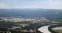
 View from southbound PA 29 north of Phoenixville.
Now in Mont Clare, PA 29 becomes Collegeville Road as it interchanges with U.S. Route 422, the Pottstown Expressway. Past the exit, PA 29 continues on its northeast alignment to Collegeville, where PA 29 turns to the north ahead of the Perkiomen Creek, becoming 2nd Avenue as it intersects the west end of the Germantown Pike in the borough center.
North of Collegeville, PA 29 becomes the Gravel Pike, paralleling the Perkiomen Creek as it proceeds north. Less than two miles (3 km) north of Collegeville, PA 29 intersects Pennsylvania Route 113.
In Schwenksville, Pennsylvania Route 73, which runs along the east bank of the Perkiomen for a short distance southeast of the area, crosses the Perkiomen and intersects PA 29. The two routes come together, joining north to Zieglersville, where PA 29 and PA 73 split, with PA 73 continuing to the northwest and PA 29 continuing north.
Near Green Lane, PA 29 breaks from its north–south alignment to pass to the east of the Upper Perkiomen Valley County Park and the Green Lane Reservoir Park. In Green Lane, PA 29 meets the western terminus of Pennsylvania Route 63. Northwest of this point, PA 29 returns to a north–south alignment at the northern edge of the Green Lane Reservoir Park.
Directly north of the reservoir in Pennsburg, PA 29 meets Pennsylvania Route 663. North of Pennsburg, PA 29 follows a northwesterly alignment to the Montgomery-Berks county line.
Berks County
The stay of PA 29 in Berks County is a brief one, as only two miles of the route are located in the county. Roughly a mile from the county line, PA 29 intersects Pennsylvania Route 100 in Hereford. PA 29 turns north onto PA 100, joining northward across the county line and into Lehigh County.
Lehigh County
Little more than three miles (5 km) from the county line, the concurrency comes to an end in Shimerville. While PA 100 heads to the northwest, PA 29 continues north toward Allentown, becoming Chestnut Street.
Now in Emmaus, PA 29 passes under Interstate 476, the Pennsylvania Turnpike's Northeast Extension, west of town before turning north onto Cedar Crest Boulevard PA 29 passes a pair of golf courses and Lehigh Valley Hospital before the southern segment terminates at exit 55 on Interstate 78 in Allentown, concurrent with Pennsylvania Route 309 at this point. One of the six regionally famous Yocco's Hot Dogs restaurants (known as Yocco's South) is located off of Route 29, in Emmaus, on Buckeye Road.
Northern segment
Luzerne County
50 miles (80 km) northwest of Dorneyville, the 74-mile (119 km) long northern segment of PA 29 begins at exit 164 on Interstate 81 in Ashley, Luzerne County. Heading west from I-81, PA 29 is a limited-access expressway containing three numbered exits and four overall, passing along the southern extents of Wilkes-Barre before returning to an at-grade road at U.S. Route 11 via a trumpet-style interchange that brings the expressway to an end. This is named the South Cross Valley Expressway.
US 11 and PA 29 join west along the west bank of the Susquehanna River to West Nanticoke, where PA 29 turns north, leaving US 11, which continues to parallel the Susquehanna for a considerable distance.
Due to the terrain of the area, the alignment of PA 29 between US 11 and Silkworth has a large amount of curves as it snakes northeast before returning west to Silkworth. At Silkworth, PA 29 returns to a northerly alignment.
In Pikes Creek, PA 29 intersects Pennsylvania Route 118. North of town, the terrain forces PA 29 to take on an erratic northwesterly routing, an alignment the route maintains into Wyoming County.
Wyoming County
Shortly after entering Wyoming County, PA 29 intersects the northern terminus of Pennsylvania Route 415 northeast of Harveys Lake. PA 29 turns to the north at this spot before making a wide turn to the east, passing through Noxen Township as it approaches Bowman Creek and the northern terminus of Pennsylvania Route 309, the same route that meets the northern terminus of PA 29's southern segment near Allentown.
North of Bowman Creek, near Evans Falls, PA 29 intersects the western terminus of Pennsylvania Route 292.
Between Evans Falls and Tunkhannock, PA 29 does not intersect any signed routes as it proceeds northeast through rural Pennsylvania. In Tunkhannock, however, PA 29 intersects both U.S. Route 6 and U.S. Route 6 Business before leaving north on Bridge Street.
PA 29 continues to the north as it enters Susquehanna County, the seventh and final county along PA 29's routing.
Susquehanna County
The southern portion of PA 29's routing through Susquehanna County takes on a nondescript feel, passing through Springville and Dimock as it proceeds north. The first signed state route that PA 29 meets in Susquehanna County, however, is located in Montrose, where PA 29 meets the Pennsylvania Route 167/Pennsylvania Route 706 concurrency, which begins just west of the intersection with PA 29. The three routes form a brief concurrency through the town before PA 29 turns north on the eastern edge of town.
Like the southern portion of the county, the routing north of Montrose lacks any notable locations or roads as PA 29 does not intersect another signed route during its northeasterly trek to the New York-Pennsylvania border, where the route becomes New York State Route 7.
History
Original route
PA 29 was created and first signed in 1928. During this time, construction began on the segment between Tunkhannock north to Springville. A year later, the stretch between Tunkhannock and Lemon, midway Tunkhannock and Springville, opened to traffic. Lemon to Springville opened the following year, in 1930.
In 1934, work started on the section between US 6 in Tunkhannock and Franklin Forks, located midway between Montrose and the state border. The construction was complete by the following year. In 1936, two major sections of the route, stretching between Evans Falls to Rosengrants, near Tunkhannock, and from Franklin Forks to the state line, were paved. A subsequent project united PA 29 into a single route, completing the road from Hazleton to Tunkhannock.
Two years later, the section from Rosengrants to Tunkhannock was paved. In 1940, the section between Bowmans Creek and Evans Falls was paved.
The first realignment of the route came in 1946 when PA 29 was routed to its current position between West Nanticoke and Silkworth, shifting the route from Cragle Hill Road and Swamp Road to U.S. Route 11 from Shickshinny to West Nanticoke. This routing replaced Pennsylvania Route 139.
The route was split in 1966, eliminating a number of overlaps that linked the two segments.
Post-split
In 1969, construction began on the South Cross Valley Expressway between Sugar Notch and the Nanticoke interchange. The expressway was extended to Interstate 81 in 1971 and opened in 1972.
Prior to construction of the US 202 expressway in 1970, PA 29 travelled entirely on Phoenixville Pike between Phoenixville and West Chester. PA 29 entered West Chester on Goshen Rd and Marshall Street ending at PA 100 in town. When the US 202 expressway was built, PA 29 was rerouted onto Morehall Rd. at Devault and ran south to junction US 202 and then end at US 30.[1] There are still today numerous road signs on Phoenixville Pike between Frazer and West Chester that label the road as PA 29.
In 1978, PA 29 was re-signed to the northern segment of the route after 12 years of not having a designation. The southern terminus was moved from West Nanticoke to the current end at I-81 exit 164 in Ashley.
There are future plans to extend the South Cross Valley Expressway in 2009.
Major intersections
Southern segment
County Location Mile[2] Destinations Notes Chester Malvern 0.00 US 30 (Lancaster Avenue)0.55 US 202Interchange. 2.46 
 I-76 / Penna. Tpk.
PA 29 passes under I-76/PA TPK. Proposed location of Great Valley Slip Ramp exit on the PA Turnpike. Phoenixville 6.72  PA 23 (Nutt Road)
Montgomery Mont Clare 10.11 US 422 (Pottstown Expressway)Interchange. Collegeville 14.39  PA 113 (Bridge Road)
Schwenksville 17.39  PA 73 east (Skippack Pike)
Southern terminus of concurrency. Zieglersville 19.63 PA 73 west (Big Road)Northern terminus of concurrency. Green Lane 24.41  PA 63 (Main Street)
Western terminus of PA 63. Pennsburg 28.99  PA 663 (Pottstown Avenue, Quakertown Avenue)
Berks Hereford 33.81  PA 100 south (Chestnut Street)
Southern terminus of concurrency. Lehigh Emmaus 37.86 PA 100 north (Kings Highway)Northern terminus of concurrency. Allentown 43.46 I-78 / PA 309Exit 55 (I-78/PA 309). 1.000 mi = 1.609 km; 1.000 km = 0.621 mi Northern segment
County Location Mile[2] # Destinations Notes Luzerne Ashley 0.00 I-81East end of the South Cross Valley Expressway Sugar Notch 1 Main Street (SR 2010) Warrior Run 2 South Main Street (SR 2008) Nanticoke 3 Sans Souci Parkway (SR 2002) 4.68 US 11West end of the South Cross Valley Expressway; eastern terminus of US 11 / PA 29 overlap Begin at-grade highway northbound and limited-access highway southbound West Nanticoke 6.20 US 11Western terminus of overlap Pikes Creek 16.72  PA 118
Wyoming Harveys Lake 24.60  PA 415
Western terminus of PA 415 Bowman Creek 30.30 PA 309Northern terminus of PA 309 Evans Falls 33.88  PA 292
Northern terminus of PA 292 Tunkhannock 39.72 US 639.85 
US 6 Bus.Susquehanna Montrose 61.30 
 PA 167 / PA 706
Western terminus of overlap 62.48 PA 167 / PA 706Eastern terminus of overlap Brookdale 74.59 NY 7Continuation into New York See also
Spur routes
- Pennsylvania Route 129 deleted
- Pennsylvania Route 229 deleted
- Pennsylvania Route 329
- Pennsylvania Route 529 deleted
- Pennsylvania Route 629 deleted
- Pennsylvania Route 729
- Pennsylvania Route 829
- Pennsylvania Route 929 deleted
References
Road transportation infrastructure of the metro Philadelphia area Interstates U.S. Routes Pennsylvania Routes New Jersey Routes Delaware Routes Named roads/streets Benjamin Franklin Parkway · Broad Street · City Avenue · Front Street · Girard Avenue · Market Street · Roosevelt Boulevard · South Street · Chestnut Street · Walnut Street
Pennsylvania Turnpike · New Jersey Turnpike · Delaware Turnpike · Atlantic City Expressway · Schuylkill Expressway · Delaware Expressway · Blue Route · Vine St Expressway · North South Freeway · Lancaster Avenue · Bethlehem Pike · Baltimore Pike · Black Horse PikeBridges Delaware Memorial Bridge · Commodore Barry Bridge · Walt Whitman Bridge · Ben Franklin Bridge · Betsy Ross Bridge · Tacony–Palmyra Bridge · Burlington–Bristol Bridge · Delaware River – Turnpike Toll BridgeTransportation infrastructure of the Lehigh Valley Interstates U.S. Routes Pennsylvania Routes New Jersey Routes County Routes Named roads/streets Bridges Albertus L. Meyers Bridge · Hill to Hill Bridge · Philip J. Fahy Memorial Bridge · Minsi Trail Bridge · Easton–Phillipsburg Toll Bridge · Northampton Street Bridge · Interstate 78 Toll Bridge
Tunnels Public transportation Lehigh and Northampton Transportation Authority (Bethlehem Loop) · Trans-Bridge Lines · NJ Transit
Airports Waterways Rail Roads of the Wyoming Valley Interstate Highways Expressways North Cross Valley Expressway, South Cross Valley Expressway, Central Scranton Expressway, North Scranton ExpresswayU.S. Routes Pennsylvania Routes Categories:- Lehigh Valley
- State highways in Pennsylvania
- Limited access Pennsylvania state routes


Wikimedia Foundation. 2010.