- Pennsylvania Route 28
-
PA Route 28
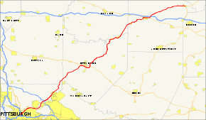
Route information Maintained by PennDOT Length: 97.6 mi[1] (157 km) Existed: 1927 – present Major junctions South end: 
 I-279/I-579 in Pittsburgh
 PA 8 in Etna

 I-76/Pa Tpk near Harmar
 US 422 in Kittanning
 PA 66 in New Bethlehem

 US 322/ PA 36 in Brookville
 I-80 near Brookville
North end:  US 219 in Brockway
Location Counties: Allegheny, Butler, Armstrong, Clarion, Jefferson Highway system Roads in Pennsylvania
Interstate • US • State • Legislative←  PA 27
PA 27PA 29  →
→Pennsylvania Route 28 is a major state highway which runs for 97 miles (157 km) from Interstate 279 and Interstate 579 at the Interstate 279 Interchange in Pittsburgh to U.S. Route 219 in Brockway in the U.S. state of Pennsylvania. The expressway from Kittanning to Pittsburgh is called the Alexander H. Lindsay Memorial Highway or the Allegheny Valley Expressway.
Contents
Route description
Pittsburgh area
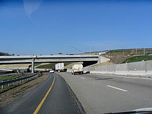
Heading north from the I-279/I-579 interchange, PA 28 is a surface street, running along the north bank of the Allegheny River. At the 40th Street Bridge, PA 28 becomes a limited-access highway, a property the road maintains throughout its run in the Pittsburgh metro area. In Etna, PA 28 interchanges with Pennsylvania Route 8 at exit 5 before departing the Blue Belt, which PA 28 is part of from I-279/I-579 to this point, at exit 6 near Aspinwall. Near Harmar Township, PA 28 meets Interstate 76 (the Pennsylvania Turnpike) and Pennsylvania Route 910 at exit 11.
Cheswick to Kittanning
 PA 28 at exit 12A (Pittsburgh Mills Blvd.).
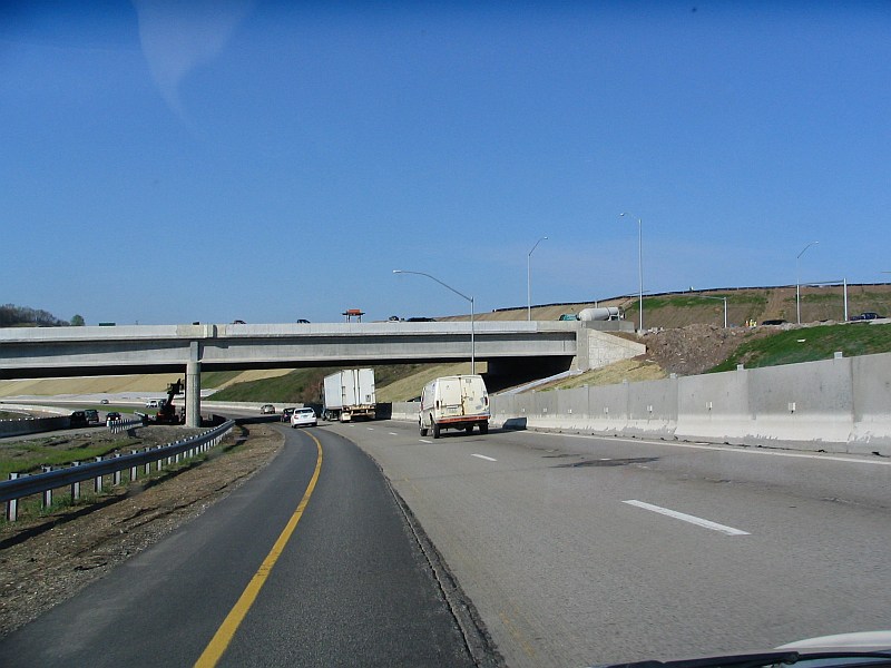
From the Pennsylvania Turnpike to U.S. Route 422 west of Kittanning, PA 28 has eight interchanges, including exits with Pittsburgh Mills Boulevard (exit 12A), Pennsylvania Route 366 (14), and Pennsylvania Route 356 (17), while continuing to parallel the Allegheny to the east. At exit 19, PA 28 merges with the limited-access US 422 and heads east along US 422 as it proceeds south of West Kittanning.
Upon crossing the Allegheny River and entering Kittanning, US 422 and PA 28 interchange with Pennsylvania Route 66. PA 66 then joins the concurrency for two miles (3 km) to an exit with U.S. Route 422 Business southeast of downtown Kittanning. Here, US 422 leaves the freeway and heads east toward Indiana while PA 28 and PA 66 remain concurrent as they progress northward.
Kittanning to New Bethlehem
The 39-mile (63 km) long freeway ends with a concurrency with Pennsylvania Route 66. In Rayburn Township, PA 28/PA 66 intersects the western terminus of Pennsylvania Route 85. After PA 85, PA 28/PA 66 head towards the northeast. In South Bethlehem, PA 28/PA 66 become North Street and Broad Street then intersecting the northern terminus of Pennsylvania Route 839.
Clarion County
After crossing the Redbank Creek, PA 28/PA 66 enters Clarion County and New Bethlehem. In downtown New Bethlehem, PA 66 splits off from PA 28 and making the PA 28/PA 66 concurrency one of the longest concurrencies in Pennsylvania. After the split, PA 28 heads northeast as Broad Street paralleling the Redbank Creek. In Hawthorn, PA 28 is called Brookville Street and meets the western terminus of Pennsylvania Route 536. North of PA 536, PA 28 begins to slide to the north instead of the northeast.
Jefferson County
In Summerville, PA 28's course begins to slide towards the northeast again and in Summerville, PA 28 is called Harrison Street. In Clover and Rose Townships, PA 28 parallels many railroads tracks that even cross it. In Brookville, PA 28 has a Wrong-way concurrency with U.S. Route 322 and Pennsylvania Route 36. The reason of the Wrong-way concurrency is that PA 28 is heading north while PA 36 is heading south on the concurrency with US 322. In downtown Brookville, PA 36 splits off from US 322/PA 28. Then after crossing the North Fork Creek, US 322/PA 28 meet the southern terminus of Pennsylvania Route 968. East of PA 968, US 322 splits off from PA 28 at a "T" interchange. East of Brookville in Pine Creek Township, PA 28 intersects Interstate 80 at exit 81 a Diamond interchange. North of I-80, PA 28 continues north as a local road without intersecting another route for more than 14 miles (23 km). PA 28 passes through the many wildlife in Pennsylvania through a forest region. In Brockway, PA 28 is called Main Street before terminating (ending) at a "T" intersection with U.S. Route 219.
History
The highway was signed in 1927 from Pittsburgh to Kittanning.
The highway was extended north to Brockway in 1928. In 1928, the route was under construction from Blawnox to Cheswick, Troy Hill Road to Oakland, and Hazen to Reitz Crossing Road. Those sections were completed the following year. In 1929, the section from Avella to Woodrow and from Hickory to Fort Cherry Road was under construction and finished the following year. In 1930, the section from Skyline Road to PA 18 was paved as well as in Venice. That year the western terminus was moved from Avella to Independence. In 1958, the highway was widened and a median installed at the interchange with the Turnpike. In 1961, the highways southern terminus was moved from Independence to PA 8 in Etna. The former section of PA 28 from South Main St. in the West End Valley to the intersection of Noblestown Rd. and Crafton Blvd. in Crafton Heights was redesignated as PA 60. The remaining 83-mile stretch from Crafton Heights to Independence was renumbered PA 50.

In 1963, this section opened to traffic from PA 8 north to the Highland Park Bridge interchange and the following year to Blawnox. Also that year, the Pittsburgh Area Transportation Plan recommended upgrading PA 28 and then PA 8, to a six-lane, limited-access highway starting 2,200 feet (670 m) west of the 31st Street Bridge and ending at the 40th Street Bridge. Full interchanges would be constructed at both bridges; however, this recommendation was not carried out. It also laid out a plan that would turn PA 28 into an expressway from Pittsburgh to Brookville, this too was not carried out.
In 1964, the highway was widened and a median installed on it between Brackenridge and the Butler County line. In 1968, construction began on the section from Blawnox to PA 910. The expressway was proposed from that point to the Butler County line. Construction also began on the section from Slate Lick to near Center Hill in the same year. In 1965, the route was moved from Courthouse Road into Kittanning to bypass the borough on its current alignment. In 1969, construction commenced on the section from PA 910 to Exit 12 and from Exit 16 to PA 356 and the Armstrong County line.
The start of the 1970s saw the construction extend from Exit 16 all the way to a new expressway alignment for US 422, also under construction, near West Kittanning. In 1971, construction commenced on the section from Exit 15 to Exit 16. In 1972, the expressway opened to traffic from Blawnox to PA 910 and from Exit 15 to US 422. However, PA 28's designation was not placed on the section from Exit 15 to Exit 16. The following year, the expressway opened from PA 910 to Exit 12.
In 1973, the route was extended to end at US 19/PA 65 at Chateau Street via Western Avenue and East Ohio Street.
In 1975, construction commenced on the section from Exit 12 to north of Tarentum; and during the following year, the construction was extended to Exit 15. In 1978, the PA 28 designation was routed onto the newly opened highway from Exit 11 to Exit 12 and from Exit 15 to Exit 16. The PA 28 designation still followed Freeport Road to connect between Exit 12 and Exit 15.
In 1980, the expressway opened from Exit 12 to Exit 13 and the PA 28 designation was moved onto this section. In 1984, the route was changed to follow Western Avenue, Allegheny Avenue, North Shore Drive, General Robinson Street, and Madison Avenue for northbound traffic, and Reedsdale Street for southbound traffic in Pittsburgh. The final section of the Allegheny Valley Expressway between Exit 13 and Exit 15 opened in 1985.
In 2011, the southbound lanes of PA 28 were shifted to bypass the intersection of the 40th Street Bridge. The northbound lanes are expected to be shifted in 2012 when an excavation lowers the roadbed of PA 28.[2]
Exit list
County Location Mile
[citation needed]# Destinations Notes Allegheny Pittsburgh 0.0 9th Street – North Shore River Avenue No southbound exit I-579 south (Veterans Bridge) – Liberty BridgeInterchange; southbound exit and northbound entrance Chestnut Street Interchange; northbound exit only 0.2 To I-279 / East Ohio StreetInterchange; no southbound entrance 1.1 1 31st Street Bridge, Rialto Street Millvale 1.9 2 40th Street Bridge Interchange northbound; at-grade intersection southbound South end of freeway 2.2 3 Millvale Etna 3.4 4 Etna Northbound exit and southbound entrance 3.9 5A R.D. Fleming Bridge (PA 8 south) – Sharpsburg Northbound exit and southbound entrance 4.2 5B PA 8 north – Butler, EtnaSigned as exit 5 southbound 5.8 6 To PA 8 south / Highland Park Bridge (Blue Belt) – AspinwallAspinwall 6.5 7 Delafield Avenue No southbound exit 7.2 8 Freeport Road, Fox Chapel Road, Waterworks Drive Blawnox 7.5 9 Blawnox Northbound exit and southbound entrance 8.6 10 R.I.D.C. Drive Harmar Township 11.6 11  PA 910 to Penna. Tpk. / I-76 – Harmarville, Harmar
Cheswick 13.4 12 Cheswick, Springdale 15.8 12A Pittsburgh Mills Boulevard Creighton 16.1 13 Russellton, Creighton Northbound exit and southbound entrance Tarentum 18.6 14  PA 366 – Tarentum, Brackenridge, New Kensington, Arnold, Lower Burrell, Fawn Township
Harrison Township 20.3 15 Natrona Heights, Fawn Township, Natrona, Brackenridge Harrison Township 23.3 16 Natrona Heights, Fawn Township, Freeport Northern end of former PA 908 (decommissioned in 1946) Butler Buffalo Township 25.0 17  PA 356 – Freeport, Butler
Armstrong North Buffalo Township 31.0 18 Slate Lick 37.1 19 US 422 west – Butler, West KittanningSouth end of US 422 overlap 39.8 A PA 66 south – Ford CitySouth end of PA 66 overlap 39.8 B 


To US 422 Bus. – Kittanning41.2 
US 422 east / US 422 Bus. west – Indiana, KittanningNorth end of US 422 overlap North end of freeway Rayburn Township 42.2  PA 85 east – Rural Valley, Plumville
South Bethlehem 59.3  PA 839 south – Mahoning Dam
Clarion New Bethlehem 59.7 PA 66 north – ClarionNorth end of PA 66 overlap Redbank Township 65.2  PA 536 east – Mayport
Jefferson Brookville 79.3 

 US 322 west / PA 36 north / PA 28 Truck north to I-80 – Leeper, Clarion
South end of US 322/PA 36 overlap 79.7 PA 36 south – PunxsutawneyNorth end of PA 36 overlap 80.2 Richards Street (SR 4005) – Richardsville, Ridgway Former PA 968 Pine Creek Township 80.9 US 322 east – ReynoldsvilleNorth end of US 322 overlap 82.0
I-80 / PA 28 Truck south – Clarion, DuBoisInterchange Brockway 97.6 US 219 – Ridgway, DuBoisPA 28 Truck

PA Route 28 Truck
Location: Brookville, Pennsylvania Existed: 1963–present Pennsylvania Route 28 Truck is a 3-mile (4.8 km) long truck route in Brookville, Jefferson County, Pennsylvania. As Route 28 travels through the Brookville city center, it becomes a narrow main street and features a relatively sharp turn near the county hospital. As a result, after the completion of Interstate 80, Route 28's truck traffic was shifted onto this freeway bypass from Exit 78 at Pennsylvania Route 36 (which Truck 28 is cosigned for its first 1/2 mile of existence) to Exit 81, where Route 28 meets the highway.
References
- ^ Pennsylvania Highways - Pennsylvania Route 28
- ^ Schmitz, Jon (September 28, 2011). "Whole new Route 28 beginning to emerge through construction". Pittsburgh Post-Gazette. http://www.post-gazette.com/pg/11271/1178066-53.stm. Retrieved October 4, 2011.
External links
Categories:- State highways in Pennsylvania
- Limited access Pennsylvania state routes


Wikimedia Foundation. 2010.