- Interstate 70 in Pennsylvania
-
This article is about the section of Interstate 70 in Pennsylvania. For the entire length of the highway, see Interstate 70.
Interstate 70
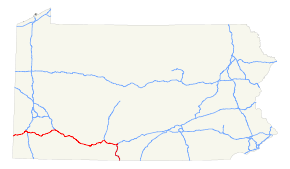
Route information Maintained by Pennsylvania DOT Length: 167.92 mi[1] (270.24 km) Major junctions West end:  I-70 at the West Virginia state line
 I-79 in Washington
 PA 43 in Fallowfield Township
 PA 51 in Rostraver Township

 in New Stanton
 I-76 in New Stanton

 I-99 / US 220 in Bedford

 I-76/US 30 in Breezewood
 US 522 near Warfordsburg
East end:  I-70 at the Maryland state line
Highway system Main route of the Interstate Highway System
Main • Auxiliary • BusinessRoads in Pennsylvania
Interstate • US • State • Legislative←  PA 69
PA 69PA 70  →
→←  PA 125
PA 127  →
→In the U.S. state of Pennsylvania, Interstate 70 runs east–west across the southwest part of the state serving the southern half of the Pittsburgh metropolitan area. About half of the route is concurrent with Interstate 76 along the Pennsylvania Turnpike (this is the oldest segment of I-70 in Pennsylvania, having been completed in 1940). I-70 is one of only a few Interstate Highways to have a traffic signal - in this case, with U.S. Route 30 at Breezewood, where it leaves the Turnpike and heads south towards Maryland.[2]
The portion of I-70 between Washington, Pennsylvania (immediately after it ends its brief concurrency with Interstate 79) and New Stanton, Pennsylvania falls well below modern Interstate Highway standards. This section, among other things, employs a jersey barrier in the very narrow median as well as very short entrance ramps at several interchanges, requiring a stop sign to be employed at these ramps instead of the typical yield sign. As the Pennsylvania Turnpike is grandfathered from Interstate standards as well as the aforementioned traffic signal in Breezewood, this makes the majority of I-70 not up to standards, with the short section south of Breezewood to Maryland as well as the 21-mile section from I-79 to West Virginia being the only sections of I-70 in Pennsylvania being up to Interstate standards.
I-70 crosses the Monongahela River on the Speers-Belle Vernon Bridge and the Youghiogheny River on the Smithton High Level Bridge.
History
By 1947, present Interstate 70 across Pennsylvania was included in the planned Interstate Highway System. The route from West Virginia split at Washington, with one branch heading northeast to meet the Pennsylvania Turnpike near Pittsburgh and the other heading east, bypassing Pittsburgh to the south (via a planned bypass of Pennsylvania Route 71) to the New Stanton interchange. The piece south from the Breezewood interchange into Maryland was also in the network.[3] The route between US 30 in Breezewood and US 522 in Warfordsburg was originally known as Pennsylvania Route 126. In 1957, preliminary numbers were assigned; the longer route via Pittsburgh (now Interstate 79 and Interstate 376) became the main line of I-70, while the southern bypass (now I-70) became Interstate 70S.[4] A southern extension of Interstate 79 (which had previously only run from Erie south to Pittsburgh) to Charleston, West Virginia in 1963 resulted in changes to I-70. On February 26, 1964, as part of the formation of Interstate 76 (east of downtown Pittsburgh), AASHTO approved a rerouting of I-70 along I-70S. The former I-70 became I-79 from Washington to downtown Pittsburgh and I-76 to and along the Turnpike to New Stanton.[5] This brought the routing of I-70 to its present form.
Exit list
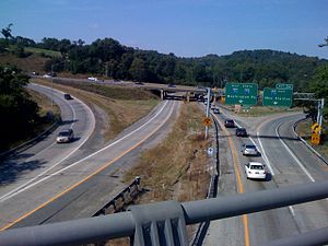 Interstate 70 (on top) merges with Interstate 79 going through Washington, Pennsylvania.
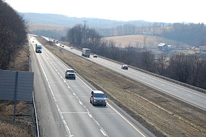 Interstate 70 through Buffalo Township in Washington County, Pennsylvania
County Location Mile[6] Exit Destinations Notes Washington Donegal Township 0.89 1 West Alexander 5.65 6  To PA 231 – Claysville
Buffalo Township 11.00 11  PA 221 – Taylorstown
North Franklin Township 14.81 15  US 40 (Chestnut Street)
Canton Township 15.96 16 Jessop Place Washington 16.65 17  PA 18 (Jefferson Avenue)
South Strabane Township 17.51 18 I-79 north – PittsburghWest end of I-79 overlap 18.56 19  US 19 (Murtland Avenue)
Signed as exits 19A (south) and 19B (north) 19.00 20  PA 136 (Beau Street)
21.02 21 I-79 south – MorgantownEast end of I-79 overlap Somerset Township 24.50 25  PA 519 – Eighty Four, Glyde
27.42 27 Dunningsville 30.50 31 Kammerer 32.54 32A  PA 917 – Ginger Hill
Bentleyville 32.94 32B To PA 917 south – BentleyvilleFallowfield Township 35.03 35  PA 481 – Monongahela, Centerville
36.43 36 Lover Westbound exit and eastbound entrance 37.46 37 Toll PA 43 – California, PittsburghSigned as exits 37A (south) and 37B (north) Speers 39.74 39 Speers 40.19 40  PA 88 – Charleroi, Allenport
Westmoreland Rostraver Township 40.72 41  PA 906 – Belle Vernon, Monessen
North Belle Vernon 41.46 42 North Belle Vernon Rostraver Township 42.13 42A Monessen Westbound exit and eastbound entrance 42.64 43 
 PA 201 to PA 837 (via Donora-Monessen Bridge) – Donora, Fayette City
Signed as exits 43A (south) and 43B (north) westbound 44.10 44 Arnold City 46.36 46 PA 51 – Uniontown, PittsburghSigned as exits 46A (south) and 46B (north) South Huntingdon Township 48.85 49 Smithton 51.13 51  PA 31 – Mt. Pleasant, West Newton
Signed as exits 51A (east) and 51B (west) 53.19 53 Yukon Sewickley Township 53.82 54 Madison New Stanton 56.87 57A Hunker Westbound exit and eastbound entrance 56.95 57B New Stanton Signed as exit 57 eastbound 57.32 To US 119 / Toll PA 66 north – Greensburg, Connellsville, Delmont I-76 west / Penna. Tpk. west – Pittsburgh, ClevelandWest end of I-76 overlap Donegal 91  PA 31 / PA 711 – Ligonier, Uniontown
Somerset Somerset 110  US 219 – Somerset, Johnstown
Bedford Bedford 146 I-99 / US 220 – Bedford, AltoonaEast Providence Township 161 I-76 east / Penna. Tpk. east – HarrisburgEast end of I-76 overlap East end of freeway US 30 east – McConnellsburg, Chambersburg, GettysburgWest end of US 30 overlap 147.05 147 US 30 west – EverettEast end of US 30 overlap; at-grade intersection West end of freeway Fulton 148.68 149 To US 30 west – Everett, South BreezewoodNo westbound entrance Brush Creek Township 151.16 151  PA 915 – Crystal Spring
155.75 156  PA 643 – Town Hill
Union Township 163.21 163  PA 731 south – Amaranth
Bethel Township 167.93 168 US 522 north – WarfordsburgWest end of US 522 overlap References
- ^ Route Log - Main Routes of the Eisenhower National System Of Interstate and Defense Highways - Table 1
- ^ Manuel Roig-Franzia, "The Town That Stops Traffic: Travelers Encounter Way Station as Way of Life in Breezewood," Washington Post, 22 November 2001, B1.
- ^ National System of Interstate Highways, August 2, 1947
- ^ Official Route Numbering for the National System of Interstate and Defense Highways, August 14, 1957
- ^ Ask the Rambler, Was I-76 Numbered to Honor Philadelphia for Independence Day, 1776?
- ^ Calculated using DeLorme Street Atlas USA 2007 software
Interstate 70Previous state:
West VirginiaPennsylvania Next state:
MarylandInterstate Highways in Pennsylvania Current Unbuilt 695 • 895Former Future Categories:- Interstate 70
- Interstate Highways in Pennsylvania


Wikimedia Foundation. 2010.