- Allegheny County belt system
-
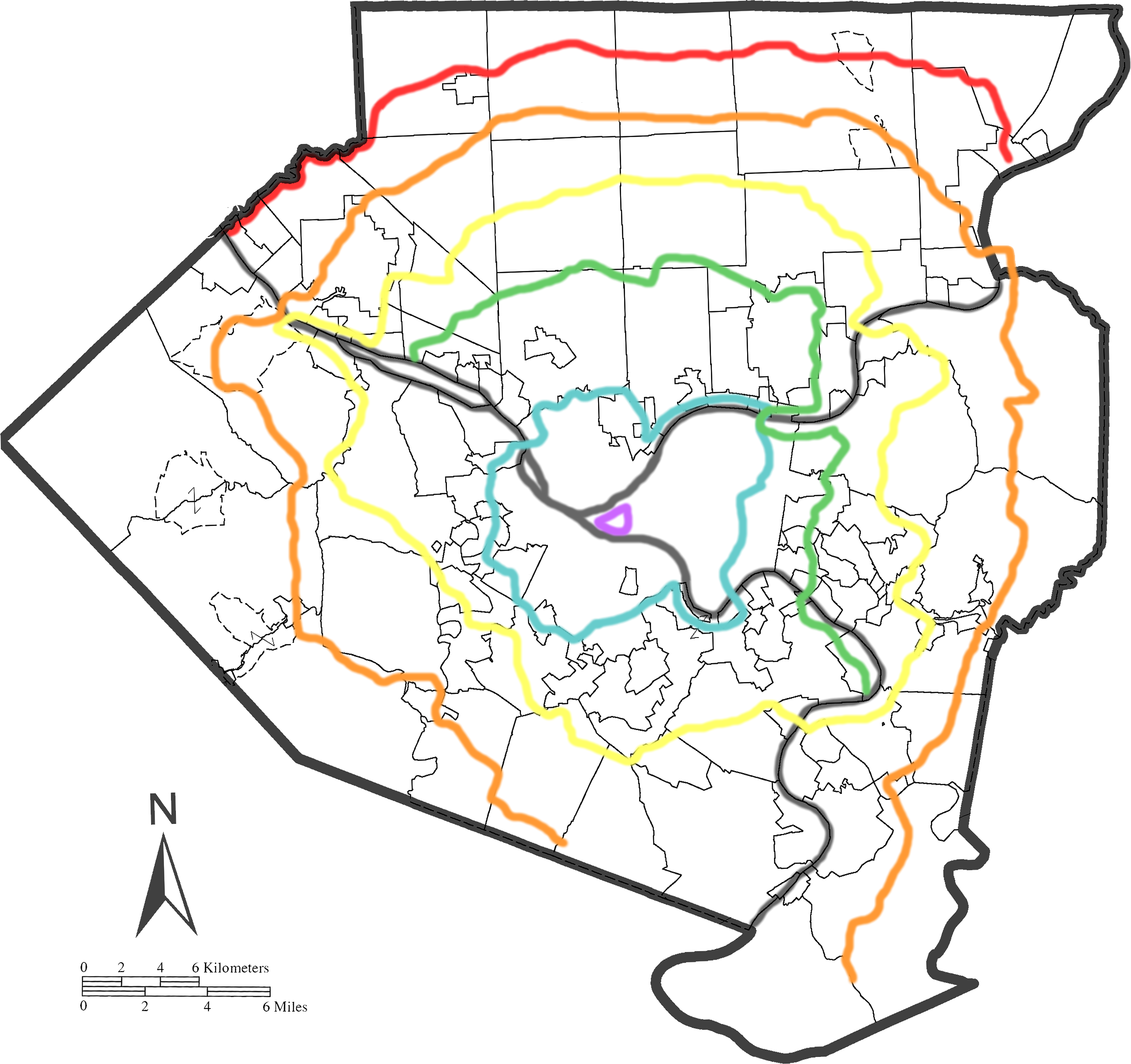
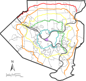 The Allegheny County belt system. (Click to expand.)
Red Belt Orange Belt Yellow Belt Green Belt Blue Belt Purple Belt (River)For belt ranks in the martial arts, see Kyū.The Allegheny County Belt System color codes miscellaneous county roads to form a unique system of routes in Allegheny County, Pennsylvania and around the city of Pittsburgh.
Unlike many major American cities that utilize number-coded limited-access roads to form belt systems, the belts in the Allegheny County Belt System are not intended to be used as a high-speed routes. Rather, the belt system is to be used as a navigational aid for motorists in unfamiliar portions of the county.[1] Roads that make up the Belt System retain their previous names. The five original routes are, from outermost to innermost, the Red, Orange, Yellow, Green, and Blue Belts. The Purple Belt was not part of the original system and was added later.
Contents
History
The Allegheny County Belt System was developed in the late 1940s by Joseph White, an engineer with the Allegheny County Department of Public Works, as a wayfarer system using a network of federal, state, and municipal roads to offer residents alternative traffic patterns which did not lead to downtown Pittsburgh's congested Golden Triangle. As such, it actually predates the Interstate Highway System developed during the Eisenhower administration.
From late 1951 to Spring 1952, the signs were posted throughout the finalized belt routes, starting with the Orange route, then Blue, Yellow, Red and Green.[2]
The belt routes were not intended as high speed or limited access roads, but instead as a well-defined road system away from the existing major arterials and their congestion.
The construction of the interstate highway system and regional parkways during the late 1950s through the early 1970s initially reduced the use and need of the belt routes. As urbanization of the county spread further out from the City of Pittsburgh, however, the Belt System helped to reduce the effects of suburban congestion. Many of the roads selected over fifty years ago today play key roles in the long-range regional transportation plans of Allegheny County. Many of the roads chosen for the belts have been converted from simple country lanes to urban collector roads and to urban arterials.
In its millennium edition, Pittsburgh Magazine (published by WQED television) recognized White as one of the one hundred most influential people of the 20th century in the Pittsburgh region. Rick Sebak from WQED television also produced a local feature on the Allegheny County Belt System in the 1990s.
The City of Pittsburgh developed a Purple Belt for the downtown area during the mid 1990s using the county system as a guideline.
Composition
The Belt System consists of six beltways. The Purple, Blue, Green, Yellow, Orange, and Red Belts travel distances of 2 miles (3.2 km), 38 miles (61 km), 39 miles (63 km), 78 miles (126 km), 92 miles (148 km), and 34 miles (55 km), respectively. The Purple, Blue, and Yellow belts are complete circular routes, beginning and ending at the same points. The Orange Belt was a complete circle until 12 miles (19 km) of the southernmost stretch (including its entire stretch through Washington County) was decommissioned in the 1970s to keep the belt system entirely in Allegheny County. It still briefly traverses Westmoreland County in New Kensington.
Prior to its acquisition by the Chevron Corporation in 1980, the Gulf Oil Corporation, with headquarters in Pittsburgh, published a map of Allegheny County prominently displaying the Belt System. Currently, Allegheny County produces maps featuring the Belt System.
Belts
Red Belt
Red Belt
Location: PA 65 in Leetsdale – 7th Avenue in Tarentum Length: 33.5 mi[3] (53.9 km) The Red Belt is the outermost belt in the system. Unlike the other belts in the system, the Red Belt does not make a part of a complete loop—instead, it runs entirely east–west across the northernmost part of Allegheny County.
The current Red Belt is 33.5 miles (53.9 km) long[3] and runs through largely rural communities.[1] It begins on PA 65 in Leetsdale in the west (just south of the Allegheny–Beaver County line) to PA 366 in Tarentum in the east. The Red Belt briefly enters Beaver County in two places where it crosses to the north bank of Big Sewickley Creek. Unlike other belts in the system, most of which access many state highways, the Red Belt only intersects numbered highways at its endpoints, along with US 19 in Marshall Township and at PA 8 in Richland Township. The original route of the belt ran from Arnold to PA 989 in West Economy.
Orange Belt
Orange Belt
Location: PA 88 in Library – PA 51 in Elizabeth Length: 91.7 mi[3] (147.6 km) The Orange Belt is longest belt in the system, running 91.7 miles (147.6 km).[3] For most of its route, it is the outermost route in the system, except for the north of the county, where the Red Belt runs. The Orange Belt was originally a complete circle until a 12-mile (19 km) stretch in the south from Bethel Park to Elizabeth was decommissioned (See decommissioned Orange Belt segment below).[citation needed]
The current Orange Belt runs through the northern, eastern,southern, and western sections of the county, connecting four county parks (including South Park and North Park) and the Pittsburgh International Airport.[1] It stretches from its southwestern terminus at PA 88 in Bethel Park northwest to Moon Township, then northeast to Richland Township, southeast to Plum, and finally southwest to its southeastern terminus at PA 51 in Elizabeth. Much of the route was previously rural, though suburban sprawl has placed it in many prominent commercial corridors.
The Orange Belt crosses or joins many Pennsylvania routes, including the entirety of PA 48, PA 50, PA 51, PA 56, PA 88, PA 366, PA 380, PA 910, and PA 978. It also crosses or joins I-376, US 22 and US 30. It crosses the Sewickley Bridge.
For 1.5 miles (2.4 km), the Orange Belt briefly enters Westmoreland County from the New Kensington Bridge to the county line on Logan's Ferry Road (formerly PA 909).
Decommissioned Orange Belt segment
Originally, the Orange Belt completed a 121-mile (195 km) circle by crossing into Washington County, but the southernmost stretch from Bethel Park to Elizabeth, including the entire 8.5-mile (13.7 km) Washington County segment, was removed in the 1970s to keep the Belt system within the Allegheny County border (with the exception of the brief stretch in Westmoreland County).
Starting at the current southwestern terminus at the intersection of Library and Clifton Roads in Bethel Park, the decommissioned Orange Belt begins at PA 88 South through Library and Finleyville (Washington County), then continues left onto Washington Avenue / Finleyville–Elrama Road, left onto PA 837 North (back into Allegheny County), and right onto PA 51 South for 2 miles (3.2 km) to the current southeastern terminus at PA 48 North.
Yellow Belt
Yellow Belt
Location: Pittsburgh Length: 77.6 mi[3] (124.9 km) The Yellow Belt is one of two belts, along with the Blue Belt, to make a complete loop around the city, over a distance of 77.6 miles (124.9 km)[3] through the northern, eastern, southern, and western sectors of the county.[1] For several miles in the southern part of the county, it is the outermost of the belts.
The Yellow Belt stretches from its southernmost point in South Park, north and west to the border of Moon, north and east to Hampton, and east as far as the border to Penn Hills/Plum before returning to the start. It crosses or follows PA 50, PA 51, PA 60, PA 65, PA 88, PA 121, PA 130, PA 148, PA 380, PA 791, and PA 910. It also crosses or follows US 19 and US 22 and also briefly follows I-79 from Neville Island to Glenfield, making it the only belt to be signed on an Interstate Highway.[4] It crosses the Neville Island Bridge and the Mansfield Bridge.
Curry Hollow Road composes a part of the Yellow Belt to the south of Pittsburgh. It connects with Lebanon Church Road at Pennsylvania Route 51 in Pleasant Hills, Pennsylvania, connecting Clairton Boulevard (PA 51) with Broughton Road, which connects with Pennsylvania Route 88 and Bethel Church Road. Curry Hollow was a former town along this road, where it crosses the CSX railroad tracks next to Jefferson Memorial Park. East of PA 51, the Yellow Belt becomes Lebanon Church Road and crosses Pennsylvania Route 885 in West Mifflin, Pennsylvania, connecting Clairton Boulevard (PA 51) with Pittsburgh-McKeesport Boulevard. The Allegheny County Airport is on the road. Both Curry Hollow Road and Lebanon Church Road are signed as SR 3048.
Green Belt
Green Belt
Location: PA 65 in Emsworth – PA 148 in McKeesport Length: 38.6 mi[3] (62.1 km) The Green Belt forms a half-circle around the city, with a length of 38.6 miles (62.1 km)[3], through suburban communities in the northern and eastern sectors of the county.[1] (The gap is due to geographic concerns rather than intersecting with other counties, as is the case with the Red Belt and the Orange Belt.)
The current Green Belt runs from its western terminus at PA 65 in Emsworth to PA 148 (and the Yellow Belt, the only point where one belt ends at another) in McKeesport, going north as far as Hampton Township. In its path around the city, the belt crosses or joins PA 8, PA 28, PA 65, PA 130, PA 148, and PA 837. It also briefly joins US 19.
The Green Belt runs through many Pittsburgh neighborhoods. Its most notable destinations include Kennywood and the Pittsburgh Zoo.
Blue Belt
Blue Belt
Location: Pittsburgh Length: 38.1 mi[3] (61.3 km) The Blue Belt is the innermost original belt in the system, making a complete 38.1-mile (61.3 km) circle around the city.[3]
The current Blue Belt runs relatively close to skirting the border of the City of Pittsburgh on all sides, though it does make excursions into border towns such as Dormont and McKees Rocks. It generally serves urban communities in the northern, southern, and eastern sectors of the county.[1] In its path around the city, the belt crosses or joins PA 8, PA 28, PA 51, PA 88, PA 121, and PA 837. It also briefly joins US 19. Only a small portion of the route (on PA 28) is a freeway. The belt crosses the Ohio River on the McKees Rocks Bridge, the Allegheny River on the Highland Park Bridge, and the Monongahela River on the Homestead Grays Bridge.
Dual Blue/Green Belt segment
For one mile in northeastern Pittsburgh, the Blue and Green Belts form the only dual-belt stretch in the system. The two belts meet at PA 28 (Blue northbound, Green southbound) at Exit 6–Highland Park Bridge. The Blue/Green Belt route runs across the bridge, around the loop, and at the intersection of Butler Street / Allegheny River Boulevard and Washington Boulevard. At this point, the belts split up; the Blue Belt continues with a right-hand turn onto Washington Boulevard (PA 8 South) and the Green Belt continues straight on Allegheny River Boulevard (beginning of PA 130 East).
Purple Belt
Purple Belt
Location: Downtown Pittsburgh Length: 2.03 mi[3] (3.27 km) The Purple Belt is the innermost colored belt in the system, running through downtown Pittsburgh. Unlike the other belts, it was established in 1995 in conjunction with the Pittsburgh Wayfinder System, a color-coded signage system downtown which helps tourists and locals find many of the common destinations in the city. (In the Wayfinder system, downtown destinations are colored purple. None of the other colors in that system correspond to the Belt System colors.) Thus, it uses a different style of signage than the other belts.
Unlike the other belts, the Purple Belt's primary intent is not for navigation around the circumference of the city, but rather to assist in navigation downtown. It is also the only one of the belts to not leave the city at any point. (The Blue Belt is the only other belt to enter the city at all.) Also, while signage for all of the other belts is maintained by the Allegheny County Department of Public Works, the Purple Belt is maintained by the City of Pittsburgh Department of Engineering and Construction.
The belt does not cross any numbered routes. It travels in a loop on four two-way streets—Stanwix Street, Fort Duquesne Boulevard/11th Street,[5] Grant Street and Boulevard of the Allies. (In the counter-clockwise direction, it follows Smithfield Street and 4th Avenue to bypass the left turn from Boulevard of the Allies onto Grant Street, which is prohibited at certain times.) This lies inside the area bounded by the Allegheny River, Interstate 579, Interstate 376 and Interstate 279.
References
- ^ a b c d e f County of Allegheny. Allegheny County Pennsylvania Information Map (Map).
- ^ "Red Belt Signs Go Up Next Week". Pittsburgh Press: p. 2. May 3, 1952. http://news.google.com/newspapers?id=ZAMiAAAAIBAJ&sjid=gk0EAAAAIBAJ&pg=2347,968108. Retrieved March 12, 2011.
- ^ a b c d e f g h i j k "Pittsburgh Belt System". http://www.pahighways.com/other/acbeltsystem.html. Retrieved 7-16-2010.
- ^ "Pittsburgh Belt System". http://www.pahighways.com/other/acbeltsystem.html. Retrieved 7-02-2008.
- ^ "Google Maps Street View". http://maps.google.com/maps/ms?ie=UTF8&hl=en&oe=UTF8&num=200&msa=0&msid=105324419178044045330.000477a1cd3681fd5c8a5&ll=40.443746,-80.003686&spn=0,359.961591&z=15&layer=c&cbll=40.443689,-80.003877&panoid=w0mYAWmHzQ_1vYR6nH9KBg&cbp=12,88.79,,2,1.25. Retrieved 3-06-2010.
External links
Categories:- Orbital roads in the United States
- Transportation in Pittsburgh, Pennsylvania
- Transportation in Allegheny County, Pennsylvania


Wikimedia Foundation. 2010.