- Interstate 579
-
Interstate 579
Route information Maintained by PennDOT Length: 1.57 mi[1] (2.53 km) Existed: 1960s – present Major junctions South end:  PA 885 in Pittsburgh
 PA 380 in Pittsburgh
North end: 


 I-279 / US 19 Truck / PA 28 in Pittsburgh
Highway system Auxiliary route of the Interstate Highway System
Main • Auxiliary • BusinessRoads in Pennsylvania
Interstate • US • State • Legislative←  PA 576
PA 580  →
→←  PA 478
I-480  →
→←  PA 875
PA 876  →
→Interstate 579 (abbreviated I-579) is a north–south Interstate Highway entirely within Pittsburgh, Pennsylvania. At 1.57 mi (2.53 km) long, it is short but not the shortest signed Interstate, an honor which belongs to I-375 in Michigan. I-579 is also known as the Crosstown Boulevard since it crosses the backside of Downtown Pittsburgh.
The northern terminus of I-579 is at Interstate 279 on the Veterans Bridge and the Interstate 279 Interchange, while the southern terminus splits into the Liberty Bridge and Boulevard of the Allies, which connects to eastbound Interstate 376. The intersection of I-579 and I-279 is in one direction only; northbound traffic on I-579 can proceed only northbound on I-279, while only southbound traffic on I-279 can exit onto I-579.
I-579 allows Liberty Bridge traffic easy access to I-279, and I-279 southbound traffic easier access to Consol Energy Center, downtown, and eastern regions of the city, while I-279 southbound continues to Heinz Field, PNC Park, and to westbound I-376 which leads to the Pittsburgh International Airport.
Construction on Interstate 579 was not completed until 1989, with the opening of the Veterans Bridge, and the opening of Interstate 579 was concurrent with the opening of an extension of Interstate 279 into the North Hills region of the Pittsburgh metropolitan area.
In the past, this was Interstate 479 and Interstate 876 prior to becoming Interstate 579.[citation needed]
Contents
Route description
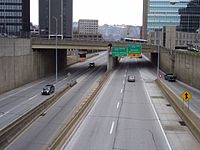 I-579 running through downtown Pittsburgh
I-579 begins at an interchange with PA 885 (Boulevard of the Allies) and the approach to the Liberty Bridge over the Monongahela River in Downtown Pittsburgh, heading to the north-northeast as a four-lane freeway. At the southern terminus, the highway has a northbound exit and southbound entrance providing access to 6th Avenue and Forbes Avenue near Duquesne University. The road passes several skyscrapers as it comes to an interchange at Centre Avenue with a northbound exit and southbound entrance that provides access to the Consol Energy Center. Immediately following is a left exit in the northbound direction and a southbound entrance that connects to 7th Avenue that serves the David L. Lawrence Convention Center. At this point, I-579 runs to the west of the Civic Arena and comes to the PA 380 interchange, a northbound exit and southbound entrance, in addition to a southbound exit and northbound entrance accessing 6th Avenue and 7th Avenue. The freeway turns north as it passes over railroad tracks to the east of Union Station, the Amtrak station serving Pittsburgh. Here, it is seven lanes total with three travel lanes in each direction and two reversible high-occupancy vehicle lanes in the center. The HOV lanes connect to Bedford Avenue near the Civic Arena at the south end. The highway turns northwest as it crosses the Allegheny River on the Veterans Bridge. A short distance after the bridge, I-579 ends at an interchange with I-279/US 19 Truck and PA 28, at which point the route merges into northbound I-279 with ramps to and from northbound PA 28.[2]
Exit list
There are no exit numbers on this Interstate Highway. The entire route is in Pittsburgh, Allegheny County.
Mile Destinations Notes 0.0 Liberty Bridge Southbound exit and northbound entrance  PA 885 south (Boulevard of the Allies) to I-376 east – Oakland, Monroeville
Southbound exit and northbound entrance 0.2 6th Avenue / Forbes Avenue Northbound exit and southbound entrance; access to Duquesne University and Robert Morris University 0.4 Centre Avenue - Consol Energy Center Northbound exit and southbound entrance 0.65 7th Avenue - Convention Center Northbound exit and southbound entrance 0.9 PA 380 east (Bigelow Boulevard)Northbound exit and southbound entrance 1.15 6th Avenue, 7th Avenue Southbound exit and northbound entrance; access to Consol Energy Center and David L. Lawrence Convention Center Veterans Bridge over the Allegheny River 1.3 PA 28 north – EtnaNorthbound exit and southbound entrance 1.57
I-279 / US 19 Truck northNorthbound exit and southbound entrance 1.000 mi = 1.609 km; 1.000 km = 0.621 mi See also
- Interstate 283 - another short interstate in Pennsylvania.
References
- ^ Route Log - Auxiliary Routes of the Eisenhower National System Of Interstate and Defense Highways - Table 2
- ^ Google, Inc. Google Maps – overview of Interstate 579 (Map). Cartography by Google, Inc. http://maps.google.com/maps?f=d&source=s_d&saddr=40.4355508,+-79.99477&daddr=40.4537,+-79.99678&geocode=FV__aAIdbmA7-w%3BFURGaQIdlFg7-w&hl=en&mra=ls&sll=40.435899,-79.993762&sspn=0.001862,0.005284&ie=UTF8&t=h&z=14. Retrieved January 15, 2011.
External links
Auxiliary routes of Interstate 79 
Auxiliary routes of Interstate 76 
Interstate Highways in Pennsylvania Current Unbuilt 695 • 895Former Future Road transportation infrastructure of the metro Pittsburgh area Interstates U.S. Routes Pennsylvania State Routes Named roads/streets Becks Run Road · Boulevard of the Allies · Brownsville Road · Canton Avenue · Carson Street · Centre Avenue · Curry Hollow Road · Fifth Avenue · Forbes Avenue · Fort Pitt Boulevard · Lebanon Church Road · Liberty Avenue · Penn Avenue · Pennsylvania Turnpike · Saw Mill Run Boulevard · Stanwix Street · Walnut StreetBridges 16th Street Bridge · 30th Street Bridge · 31st Street Bridge · 40th Street Bridge · Birmingham Bridge · Fort Duquesne Bridge · Fort Pitt Bridge · George Westinghouse Bridge · Glenwood Bridge · Highland Park Bridge · Homestead Grays Bridge · Hot Metal Bridge · Liberty Bridge · McKees Rocks Bridge · Panther Hollow Bridge · Schenley Bridge · Senator Robert D. Fleming Bridge · Smithfield Street Bridge · South Tenth Street Bridge · Three Sisters (Roberto Clemente Bridge, Andy Warhol Bridge, Rachel Carson Bridge) · Veterans Bridge · West End BridgeTunnels Wayfinder systems Categories:- Interstate Highways in Pennsylvania
- Three-digit Interstate Highways
- Interstate 76 (east)


Wikimedia Foundation. 2010.