- Point State Park
Geobox Protected Area
name = Point State Park
native_name =
other_name =
other_name1 =
category_local = Pennsylvania State Park
category_iucn = V
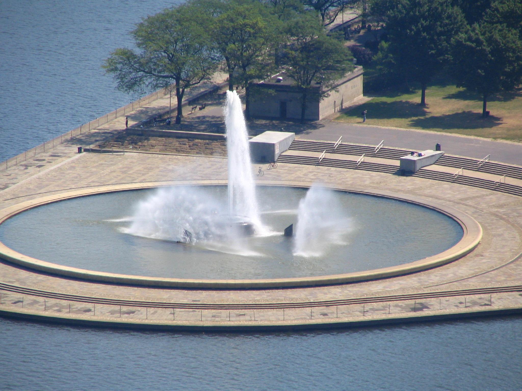
image_caption = Point State Park and the fountain
etymology_type = Named for
etymology = the Point of confluence of the Allegheny andMonongahela River s forming theOhio River
country = United States
state = Pennsylvania
region_type = County
region = Allegheny
district =
city = Pittsburgh
location =
lat_d = 40
lat_m = 26
lat_s = 30
lat_NS = N
long_d = 80
long_m = 00
long_s = 43
long_EW = W
location_note = cite web
url=Gnis3|1184180
title=Point State Park
date =August 2 1979
work=Geographic Names Information System
publisher=United States Geological Survey
accessdate=2008-05-26]
elevation_imperial = 718
elevation_round = 1
elevation_note =
area_unit = acre
area_imperial = 36
area_round = 1
area1_imperial =
area1_type =
length_imperial =
length_orientation =
width_imperial =
width_orientation =
highest =
highest location =
highest_lat_d =
highest_lat_m =
highest_lat_s =
highest_lat_NS =
highest_long_d =
highest_long_m =
highest_long_s =
highest_long_EW =
highest_elevation_imperial =
lowest =
lowest_location =
lowest_lat_d =
lowest_lat_m =
lowest_lat_s =
lowest_lat_NS =
lowest_long_d =
lowest_long_m =
lowest_long_s =
lowest_long_EW =
lowest_elevation_imperial =
biome =
biome_share =
biome1 =
biome1_share =
geology =
geology1 =
plant =
plant1 =
animal =
animal1 =
established_type =
established = 1974
management_body = Pennsylvania Department of Conservation and Natural Resources
management_location =
management_lat_d =
management_lat_m =
management_lat_s =
management_lat_NS =
management_long_d =
management_long_m =
management_long_s =
management_long_EW =
management_elevation =
visitation =
visitation_year =
free_type =
free =
free1_type =
free1 =

map_caption = Location of Point State Park in Pennsylvania
map_locator = Pennsylvania
map_first =
website = [http://www.dcnr.state.pa.us/stateparks/parks/point.aspx Point State Park] Infobox_nrhp | name =Forks of the Ohio
nrhp_type = nhl
caption =
location=
locmapin =
area =
built =
architect=
architecture=
designated=October 9 1960 cite web|url=http://tps.cr.nps.gov/nhl/detail.cfm?ResourceId=473&ResourceType=Site |title= Forks of the Ohio |accessdate=2008-07-02|work=National Historic Landmark summary listing|publisher=National Park Service]
added =October 15 ,1966
governing_body =
refnum=66000643cite web|url=http://www.nr.nps.gov/|title=National Register Information System|date=2007-01-23|work=National Register of Historic Places|publisher=National Park Service]Point State Park is a Pennsylvania state park on convert|36|acre|km2|2 in Downtown Pittsburgh, Allegheny County,
Pennsylvania , USA, at the confluence of the Allegheny and Monongahela rivers, forming theOhio River .Built on land acquired via
eminent domain from industrial enterprises in the 1950s, the park opened in1974 when construction was completed on its iconic fountain. Pittsburgh settled on the current design after rejecting an alternative plan for aPoint Park Civic Center designed byFrank Lloyd Wright .The park also includes the outlines and remains of two of the oldest structures in Pittsburgh, Fort Pitt and
Fort Duquesne . TheFort Pitt Museum , housed in the MonongahelaBastion of Fort Pitt, commemorates theFrench and Indian War (1754–1763), in which the area soon to become Pittsburgh was a major battlefield.Recreation
Today the park provides recreational space for workers, visitors, and residents in downtown Pittsburgh and also acts as the site for major cultural events in the city, including the
Three Rivers Arts Festival and Three Rivers Regatta. The park, a registeredNational Historic Landmark , is operated by thePennsylvania Bureau of State Parks .cite web
url = http://www.dcnr.state.pa.us/stateparks/parks/point.aspx
title = Point State Park
accessdate = 2007-01-20
publisher =Pennsylvania Department of Conservation and Natural Resources ]The Fountain
The fountain in Point State Park, which sprays water up to 150 feet (46 m) in the air at the head of the
Ohio River , draws upon water from the "Wisconsin Glacial Flow," anunderground river that passes beneath the park. [ cite web | url = http://www.clpgh.org/exhibit/neighborhoods/point/point_n77.html | title = The Point: The Underground River | accessdate = 2008-05-24 | publisher = Carnegie Library of Pittsburgh]Renovations
Michael DeBerardinis, Secretary of the
Pennsylvania Department of Conservation and Natural Resources , announced a $25 million dollar plan to renovate Point State Park onOctober 11 ,2006 . The plans call for improving the green spaces within the park, expanding recreational opportunities, preserving historical installations, and updating outdated amenities. The project is scheduled to be completed within four years, with the majority of the work to be completed in time for Pittsburgh's 250th anniversary celebration in 2008.Cite news|url=http://www.post-gazette.com/pg/06285/729339-53.stm|title=State will provide $25 million for Point State Park|author=Don Hopey|work=Pittsburgh Post-Gazette |date=October 12, 2006]Sections of the park have fallen into disuse since it was established in 1974. The
homeless have used the trenches surrounding the foundations of the remains ofFort Pitt as a temporary shelter for years.Graffiti on the structures of the park has become a major problem. Sections of the park are littered with fence posts, cut logs, plastic drums, and rolled up snow drift fencing. The walkways have become cracked and are beginning to fall apart. The goal of the restoration project is to reestablish the park as a recreational destination.Plans for improving the park include installing new pumps and pipes in the fountain, establishing a seating area around the fountain and a wading area for children, restoring the river walk with steps that lead into the river, building kiosks for information and concessions, renovating the rest rooms, renovating the
water taxi landings and surrounding docks, and installing wirelessinternet access hubs.These plans are not being put into place without some controversy. On
January 25 ,2007 , 13 members of two locallabor union s were arrested for blocking access by contractors to the work sites at the remnants of Fort Pitt. The unions were protesting the use of four nonrepresented workers by the contractor. In addition, advocates for historical preservation disagreed with the decision to bury the remnants of the fort's walls, which could damage the bricks and remove the walls from public access. [ cite web | url = http://www.pittsburghlive.com/x/pittsburghtrib/news/cityregion/s_490354.html | title = 13 arrested at Point State Park | accessdate = 2007-01-26 | author = Allison M. Heinrichs | publisher = Pittsburgh Tribune-Review]Point State Park was reopened to the public in the spring of 2008. The renovation process took a year and a half to complete. [cite web | url = http://www.post-gazette.com/pg/08143/883885-53.stm | title = Refurbished Point State Park to open May 30 | accessdate = 2008-05-22 | author = Mark Belko | publisher = Pittsburgh Post-Gazette]
History
The confluence of the Allegheny and Monongahela rivers, creating the Ohio River, has greatly impacted the history of Point State Park. It was once at the center of river travel, trade, and even wars throughout the pioneer history of western Pennsylvania. During the mid 1700s, the armies of France and the Great Britain carved paths through the wilderness to control the point area and trade on the rivers. The French built
Fort Duquesne in 1754 on foundations ofFort Prince George , which had been built by the colonial forces ofVirginia .cite book | author=Alberts, Robert C. | title=The Shaping of the Point: Pittsburgh's Renaissance Park | location=Pittsburgh | publisher=University of Pittsburgh Press | year=1980 | id=ISBN 0-8229-3422-1]The French held Fort Duquesne during the
French and Indian War , and it became one of the focal points for that war because of its strategic riverside location in disputed territory. The French held the fort successfully early in the war, turning back the expedition led by GeneralEdward Braddock . A smaller attack by James Grant in September1758 was repulsed, but with heavy losses. Two months later, onNovember 25 , theForbes Expedition , under General John Forbes, captured the site after the French destroyed Fort Duquesne the day before. The British built a much larger fort on the site and named it Fort Pitt.The Forbes Expedition was successful where the Braddock expedition had failed because of the
Treaty of Easton , in which local American Indians agreed to abandon their alliance with the French. American Indians, primarily Delawares andShawnee , made this agreement with the understanding that the British military would leave the area after the war. The Indians wanted atrading post on the spot, but they did not want a British army garrison. The British, however, built Fort Pitt on the site, naming it afterWilliam Pitt the Elder .As a result, in 1763 local Delawares and Shawnees took part in
Pontiac's Rebellion , an effort to drive the British from the region. The Indians'siege of Fort Pitt began onJune 22 1763 , but the fort was too strong to be taken by force. In negotiations during the siege, the commander of Fort Pitt gave two Delaware emissaries blankets that had been exposed to smallpox, in hopes of infecting the surrounding Indians and ending the siege. The attempt was probably unsuccessful, and onAugust 1 ,1763 , most of the Indians broke off the siege to intercept an approaching force under ColonelHenry Bouquet , resulting in theBattle of Bushy Run . Bouquet fought off the attack and relieved Fort Pitt on August 20.After Pontiac's War, Fort Pitt was no longer necessary to the British Crown, and was abandoned to the locals in 1772. At that time, the Pittsburgh area was claimed by both Virginia and Pennsylvania, and a power struggle for the region commenced. Virginians took control of Fort Pitt, and for a brief while in the 1770s it was called Fort Dunmore, in honour of Virginia's Governor Lord Dunmore. The fort was a staging ground in
Dunmore's War of 1774.During the
American Revolutionary War , Fort Pitt was the headquarters for the western theatre of the war.A small brick building called the Blockhouse—actually an outbuilding known as a
redoubt —remains in Point State Park, the only intact remnant of Fort Pitt. It was erected in 1764, and is believed to be the oldest building, not only in Pittsburgh, but in western Pennsylvania. Used for many years as a house, the blockhouse was purchased and has been preserved for many years by the Daughters of the American Revolution, who open it to the public.Nearby state parks
The following state parks are within convert|30|mi|km|0 of Point State Park:cite web
last = Michels
first = Chris
year = 1997
url = http://www2.nau.edu/~cvm/latlongdist.html
title = Latitude/Longitude Distance Calculation
publisher =Northern Arizona University
accessdate = 2008-04-23] [cite web
url = http://www.dcnr.state.pa.us/stateparks/parks/region_pittsburgh.aspx
title = Find a Park Pittsburgh and its Countryside
accessdate = 2007-01-20
publisher =Pennsylvania Department of Conservation and Natural Resources ] [cite map |scale = 1:65,000| publisher= Pennsylvania Department of Transportation, Bureau of Planning and Research, Geographic Information Division
url= ftp://ftp.dot.state.pa.us/public/pdf/BPR_pdf_files/Maps/GHS/Roadnames/allegheny_GHSN.PDF
title= 2007 General Highway Map Allegheny County Pennsylvania
accessdate= 2007-07-27 "Note: shows Point State Park"]
*Allegheny Islands State Park (Allegheny County)
*Hillman State Park (Washington County)
*Raccoon Creek State Park (Beaver County)References
External links
*
Wikimedia Foundation. 2010.