- Pennsylvania Route 885
-
PA Route 885
Route information Maintained by PennDOT Length: 14.1 mi[1] (22.7 km) Existed: 1928 – present Major junctions South end:  PA 837 in Clairton
 I-376 in Pittsburgh
North end:  I-579 in Pittsburgh
Location Counties: Allegheny Highway system Roads in Pennsylvania
Interstate • US • State • Legislative←  PA 884
PA 886  →
→Pennsylvania Route 885 is a 14.1 mi (22.69 km) long north–south state highway in the U.S. State of Pennsylvania. It runs from Pennsylvania Route 837 in Clairton to Interstate 579 in Pittsburgh. The route is entirely within Allegheny County and serves as a connector between the City of Pittsburgh and its southern suburbs.
Contents
Route description
Clairton to Oakland
Route 885 starts in the Wilson section of Clairton at the intersection with State Street (Pennsylvania Route 837). From there, the route runs uphill heading southwest as Walnut Avenue before turning north at the west end of Clairton. Outside the vicinity, the route journeys northwest as Clairton Road while traversing a rural and mountainous region of Allegheny County. Route 885 then travels towards the north while passing through the western regions of West Mifflin. Shortly after becoming a four-lane undivided highway, it bypasses the Century III Mall to the east, the fourth largest shopping mall in the Greater Pittsburgh area.[1]
Route 885 briefly runs concurrent with Lebanon Church Road (Yellow Belt) before bearing north as Lebanon Road where it passes underneath a runway of Allegheny County Airport. North of the airport, it journeys past elevations of up to 1,200 feet before turning northwest onto Mifflin Road.[1] Route 885 then enters the city of Pittsburgh via the neighborhood of Hays as Ashby Street where it meets Pennsylvania Route 837 at an interchange. Shortly after, it crosses the Monongahela River via the Glenwood Bridge and enters the neighborhood of Hazelwood.[1]
In Hazelwood, Route 885 travels northwest as Second Avenue and Irvine Street. In the northern section of Hazelwood, the route turns onto Greenfield Avenue before running beneath the railroad tracks. From there, Route 885 again becomes Second Avenue and parallels the Monongahela River to the south and the Three Rivers Heritage Trail to the north. Upon entering Oakland, the academic and cultural center of Pittsburgh, the route turns north onto Bates Street and right away has an interchange with Interstate 376 (overlapped with US 22 and US 30). Route 885 follows Bates Street before bearing west onto the Boulevard of the Allies.[1]
Boulevard of the Allies
The northernmost segment of Route 885 is designated as the Boulevard of the Allies in dedication of the Allies victory in World War I.[2] The route joins the Boulevard less than a mile west of Schenley Park in Oakland.[1] The route embarks across the Southern sectors of Oakland as a four-lane divided highway. As the route journeys west, it meets Interstate 376 and Forbes Avenue at a partial interchange near Birmingham Bridge. Route 885 then travels along a cliff, parallel to both Interstate 376 and the Monongahela River to the south and enters the Pittsburgh neighborhood of Bluff, also known as Uptown. Route 885 also passes to the south of Mercy Hospital and Duquesne University before ending at a partial interchange with Interstate 579 and the Liberty Bridge in Downtown Pittsburgh.[1]
History
Planning began in the early 1920s for the Boulevard of the Allies, extending east from Second Avenue and Grant Street to Oakland.[3] The first part of the Boulevard of the Allies was dedicated on August 8, 1921, and the entire highway opened to traffic on October 2, 1923, including several viaducts and widenings of the existing Emily Street to a terminus at Wilmot Street and Forbes Avenue. One of the first interconnected traffic signal systems was installed a month later (November 13) on the Boulevard downtown as an experiment.[4] Prior to completion, its cost was reported as $1.6 million per mile, the most expensive road in the world at the time.[5] In 1924, the Boulevard became part of an alternate bypass route of the Lincoln Highway, whose original route used Bigelow Boulevard into downtown; this left the Boulevard at Forbes Avenue (its original terminus), following Beeler Street, Wilkins Avenue, and Dallas Avenue to the main route on Penn Avenue near East Liberty.[6][7]
U.S. Route 22 and U.S. Route 30 were designated along the William Penn and Lincoln Highways through Pittsburgh in 1926; the Boulevard of the Allies bypass alignment was chosen for both routes.[8] The portion of the road east from Forbes Avenue to Bates Street, still known as Wilmot Street, became a part of Route 885 by 1940.[9] With the completion of the Penn-Lincoln Parkway East in the late 1950s, US 22 and US 30 were moved off the Boulevard, and PA 885 was extended west a short distance to the interchange near the Birmingham Bridge. The construction of I-579 in the early 1960s cut the path of westbound Boulevard traffic into downtown;[10] eventually the PA 885 designation was continued west to this interchange.
Major intersections
The entire route is in Allegheny County.
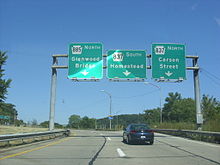
Location Mile Destinations Notes Clairton 0.00 PA 837 south (State Street)Southern terminus of PA 885. West Mifflin Lebanon Church Road Yellow Belt. Pittsburgh PA 837 (Riverton Street)Interchange. 
 I-376/US 22/US 30 East (Penn-Lincoln Parkway)
Exit 73 (I-376/US 22/US 30). Eastbound entrance. I-376/US 22/US 30 (Penn-Lincoln Parkway)Exit 72B (I-376/US 22/US 30). Westbound exit. I-579 north (Crosstown Boulevard)Northern terminus of PA 885. Southern terminus of I-579. 1.000 mi = 1.609 km; 1.000 km = 0.621 mi References
- ^ a b c d e f g "Overview of PA 885". Google Maps. http://maps.google.com/maps?f=d&source=s_d&saddr=Walnut+Ave&daddr=40.4074341,-79.9433367+to:Unknown+road&geocode=FZYOZwIdhf08-w%3BFYqRaAIdWCk8-ykJCEW5t_E0iDH3p0sRjEmQvw%3BFQQAaQIdCmM7-w&hl=en&mra=dme&mrcr=0&mrsp=0&sz=18&via=1&sll=40.30874,-79.8876&sspn=0.002127,0.005284&ie=UTF8&ll=40.35387,-79.886398&spn=0.136049,0.338173&z=12. Retrieved 02-12-2010.
- ^ "Pittsburgh In Site". Pittsburgh In Site. 2007. http://www.wqed.org/ondemand/pgh_insite/?id=21. Retrieved 02-12-2011.
- ^ American Historical Society, History of Pittsburgh and Environs, Volume III, 1922, p. 697
- ^ G.M. Hopkins Co., Volume 1 - Central Pittsburgh: Wards 1-6 and 9, 1923
- ^ University of Pittsburgh, Historic Pittsburgh - Chronology (1921-1923), accessed October 2007
- ^ Lincoln Highway Resource Guide, Appendix A - Lincoln Highway Chronology
- ^ Mixer's motor maps and tours. New England Hotels Pub. Corp.. 1 January 1925. http://books.google.com/books?id=ijlKAAAAMAAJ. Retrieved 3 October 2010.
- ^ Gulf Refining Company, Map No. 4: Automobile Roads in Pennsylvania (H.M. Gousha Company), 1928
- ^ Pennsylvania Department of Highways, Official Road Map of Pennsylvania, 1940
- ^ Pennsylvania Department of Highways, General Highway Map: Allegheny County, Pennsylvania, 1964
External links
Categories:- State highways in Pennsylvania
- Transportation in Allegheny County, Pennsylvania


Wikimedia Foundation. 2010.