- Youghiogheny River
Geobox River
name = Youghiogheny River
native_name =
other_name =
other_name1 =

image_size = 300
image_caption = Ohiopyle Falls along the Youghiogheny
country =United States
state =Pennsylvania
state1 =Maryland
state2 =West Virginia
region_type = Counties
region = Allegheny, PA
region1 = Westmoreland, PA
region2 = Fayette, PA
region3 = Somerset, PA
region4 = Garrett, MD
region5 = Preston, WV
city = McKeesport, PA
city1 = Connellsville, PA
length_imperial = 122
length_note = Gnis|595217]
watershed_imperial = 1715
watershed_note = Based on information fromUnited States Geological Survey (USGS); [http://waterdata.usgs.gov/nwis/uv?03083500 USGS 03083500 Youghiogheny River at Sutersville, PA] retrieved March 17, 2007. Sutersville is several miles upriver from McKeesport and thus the real figure is higher.]
discharge_location = Sutersville, PA
discharge_imperial = 3477
discharge_max_imperial = 35500
discharge_min_imperial = 717
discharge_note = USGS, [http://waterdata.usgs.gov/nwis/annual/?referred_module=sw&site_no=03083500&por_03083500_5=1822631,00060,5,1921,2005&year_type=W&format=html_table&date_format=YYYY-MM-DD&rdb_compression=file&submitted_form=parameter_selection_list Table of average annual daily discharges for Youghiogheny River at Sutersville, PA] , retrieved March 17, 2007. Figure cited is for 2005, most recent year for which figures are available.]
discharge1_location = Oakland, MD
discharge1_imperial = 329
discharge1_note = USGS, [http://waterdata.usgs.gov/nwis/annual/?referred_module=sw&site_no=03075500&por_03075500_1=1382607,00060,1,1941,2005&year_type=W&format=html_table&date_format=YYYY-MM-DD&rdb_compression=file&submitted_form=parameter_selection_list Table of average annual daily discharge for Youghiogheny River at Oakland, PA] , retrieved March 17, 2007. FFigure cited is for 2005, most recent year for which figures are available.]
source_name = Silver Lake
source_location =
source_district =
source_region = Preston County
source_state = WV
source_country =
source_lat_d = 39
source_lat_m = 15
source_lat_s = 00
source_lat_NS = N
source_long_d = 79
source_long_m = 29
source_long_s = 30
source_long_EW = W
source_elevation_imperial = 2500
source_length_imperial =
mouth_name =Monongahela River
mouth_location = McKeesport
mouth_district =
mouth_region = Allegheny County
mouth_state = PA
mouth_country =
mouth_lat_d = 40
mouth_lat_m = 21
mouth_lat_s = 19
mouth_lat_NS = N
mouth_long_d = 79
mouth_long_m = 52
mouth_long_s = 16
mouth_long_EW = W
mouth_elevation_imperial = 718
mouth_elevation_note =
tributary_left =
tributary_left1 =
tributary_right =Casselman River
tributary_right1 =
free_name =
free_value =
map_size = 300
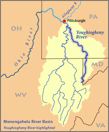
map_caption = Map of the Monongahela River basin, with the Youghiogheny River highlighted.The Youghiogheny River, or the Yough River for short, is atributary of theMonongahela River , approximately 122 mi (195 km) long, in theU.S. states ofWest Virginia ,Maryland , andPennsylvania . It drains an area on the west side of theAllegheny Mountains northward into Pennsylvania, providing the drainage for extreme western Maryland in the watershed of theMississippi River .Geography
The Youghiogheny rises in northern West Virginia, in Preston County southeast of Kingwood and near
Backbone Mountain . The headwaters are approximately 10 mi (16 km) north of the headwaters of the North Branch of thePotomac River . It flows NNE intoGarrett County, Maryland , flowing north past Oakland and roughly parallel to the West Virginia border, separated by approximately 3 mi (5 km). It enters southwestern Pennsylvania on the border between Fayette and Somerset counties. It flows northwest through a gap inChestnut Ridge and then past Connellsville. It joins the Monongahela from the southeast at McKeesport, southeast of Pittsburgh.Upstream from
Confluence, Pennsylvania , approximately 6 mi (10 km) north of Pennsylvania border, the river is impounded by the 184 ft (56 m) high Youghiogheny Dam to form theYoughiogheny River Lake , a reservoir that stretches upstream into northern Maryland. The dam was completed in 1944 primarily forflood control.History
In the colonial era and in the early United States, the valley of the river provided an important route of access through the mountains for settlers and military forces from
Virginia to theOhio Country of Western Pennsylvania. In 1754, as a militia officer of the British colony of Virginia,George Washington followed the river in an attempt to find a water route toFort Duquesne , then held by the French.During the uncommonly severe winter of 1787-88,
American pioneers to the Northwest Territory departedNew England and cut trails westward through the mountains. At Sumrill’s Ferry, present-dayWest Newton, Pennsylvania , on the Youghiogheny River, the men built flatboats which carried them down the Youghiogheny River to theMonongahela River , and then to theOhio River , and onward to theNorthwest Territory .Zimmer, "True Stories from Pioneer Valley", 14-17.]A former pioneer fort at Somerville, Pennsylvania was inundated by the building of the Youghiogheny Dam. Perryopolis in northern Fayette County, Pennsylvania is the site of the George Washington Grist Mill. The
Youghiogheny River Trail follows the river in southwestern Pennsylvania southeast of Connellsville.Fallingwater , designed byFrank Lloyd Wright , is located in the river valley southeast of Connellsville.A portion of the river in Maryland has been set aside by the state as Youghiogheny Scenic and Wild River.
Recreation
Part of the
Great Allegheny Passage , a multi-use trail along the formerPittsburgh and Lake Erie Railroad right-of-way extends from Confluence to McKeesport. From Confluence, it connects toWashington, DC , and will soon connect from McKeesport to Pittsburgh.recreation:
* Top Yough, nearSwallow Falls State Park (Class IV-V)
* Upper Yough, from Sang Run toFriendsville, Maryland (Class IV-V)
* Lower Yough, which runs throughOhiopyle State Park fromOhiopyle, Pennsylvania to Bruner Run (Class III-IV)
* Middle Yough, fromConfluence, Pennsylvania to Ohiopyle (Class II)
* Ohiopyle Falls inOhiopyle State Park : this spectacular 18-ft waterfall is legal for kayakers and canoeists to run on "only" one weekend a year (Class IV), during a race and festival.
* Further downstream, near Connellsville, PA, the river is much slower, without whitewater rapids, and is able to be piloted by personal tubes, kayaks or canoes.The Youghiogheny is also known for fishing, having brown andrainbow trout , as well as smallmouth above the power plant discharge.Crossings
ee also
*
List of Maryland rivers
*List of Pennsylvania rivers
*List of West Virginia rivers
*Meshach Browning (1781-1859), early backwoodsman and explorer of the Youghiogheny countryTreatment in fiction
The Youghiogheny River was likely the inspiration for the fictional Yuggogheny River, whose valley was used by Michael Chabon for the setting of his short story "In the Black Mill" from the 2000 collection "Werewolves in their Youth". In Chabon's 2000 Pulitzer Prize winning novel "The Amazing Adventures of Kavalier & Clay", an expert or experts on Yuggogheny cannibal cults are present at the party where Joe Kavalier saves Salvador Dalí from drowning.
References
* Palmer, Tim (1984). "Youghiogheny: Appalachian River". University of Pittsburgh Press. ISBN 0822953617.
External links
* [http://waterdata.usgs.gov/pa/nwis/current/?type=flow U.S. Geological Survey: PA stream gaging stations]
* [http://www.lrp.usace.army.mil/rec/lakes/youghiog.htm U.S. Army Corps of Engineers: Youghiogheny River Lake]
* [http://www.dnr.state.md.us/publiclands/western/youghiogheny.html State of Maryland: Youghiogheny Scenic and Wild River]
* [http://www.fallinpa.com/fallinpa/railsToTrails.jsp?section=youghiogheny Youghiogheny River Trail]
* [http://www.watsonschoice.com/GuideBook/DayTrips/Attractions/YoughioghenyRiverTrail.htm Youghiogheny River Trail]
* [http://www.americanwhitewater.org/rivers/id/753/ National Whitewater River Inventory: Upper Yough]
* [http://www.americanwhitewater.org/rivers/id/1687/ National Whitewater River Inventory: Lower Yough]
* [http://www.americanwhitewater.org/rivers/id/1686/ National Whitewater River Inventory: Middle Yough]
* [http://www.americanwhitewater.org/rivers/id/3192/ National Whitewater River Inventory: Ohiopyle Falls]
* [http://wvrivers.org West Virginia Rivers Coalition]
Wikimedia Foundation. 2010.