- New York State Route 7
-
This article is about the current alignment of NY 7. For previous alignments of NY 7, see New York State Route 7 (disambiguation).
NYS Route 7

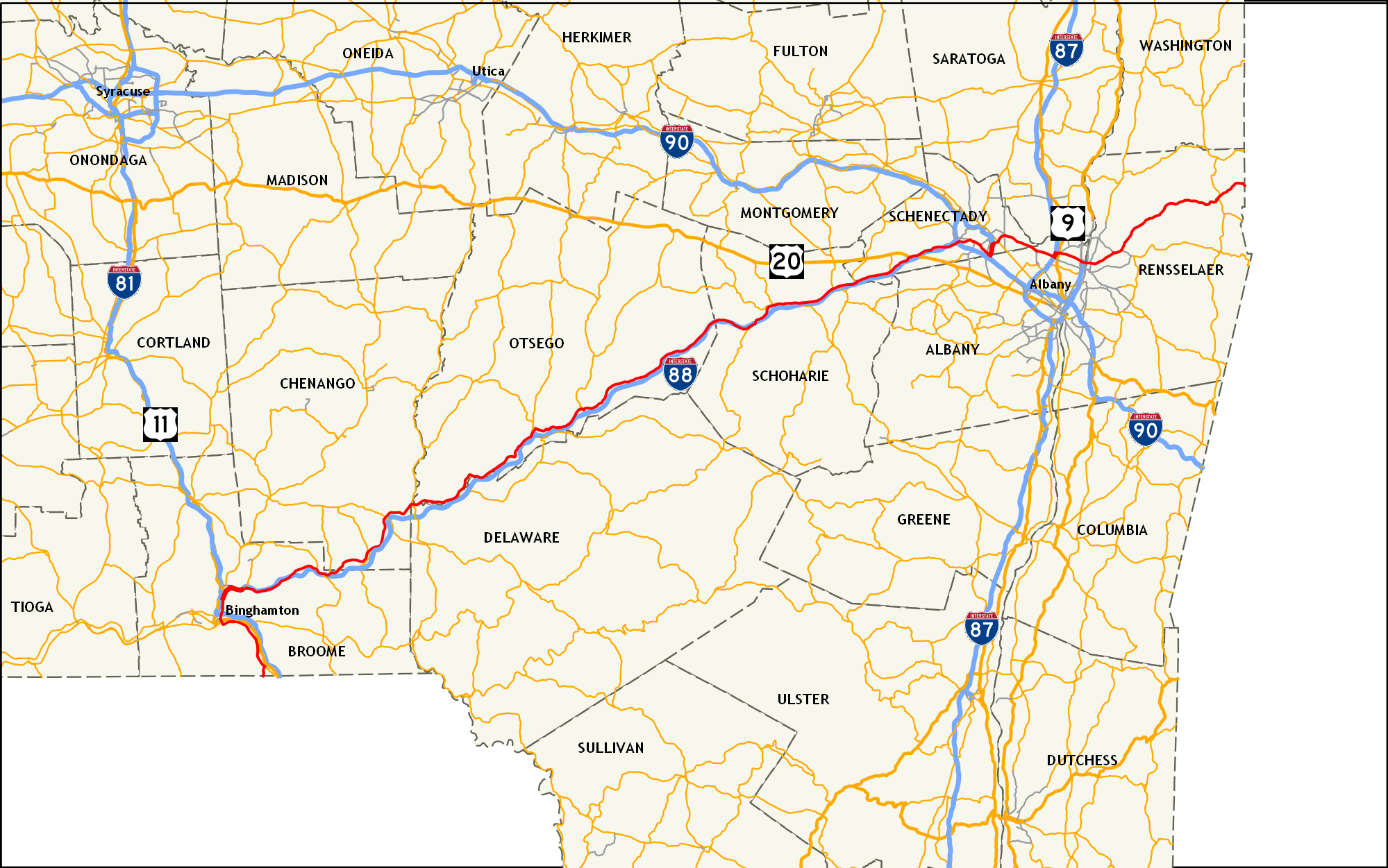
Map of eastern New York with NY 7 highlighted in redRoute information Maintained by NYSDOT and the cities of Binghamton and Oneonta Length: 180.47 mi[3] (290.44 km) History: Designated NY 9 in 1924;[1] renumbered to NY 7 in 1927[2] Major junctions West end:  PA 29 at Conklin
 I-81 / NY 17 in Binghamton
 NY 8 in Sidney
 NY 28 in Oneonta
 US 20 in Duanesburg
 NY 5 in Schenectady
 I-87 in Latham
 I-787 in Green Island
East end:  VT 9 at Hoosick
Location Counties: Broome, Chenango, Otsego, Schoharie, Schenectady, Albany, Rensselaer Highway system Numbered highways in New York
Interstate • U.S. • N.Y. (former) • Reference • County←  NY 6N
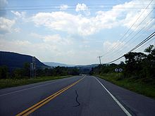
NY 6NNY 8 →New York State Route 7 (NY 7) is a 180-mile (290 km) long New York State Highway that runs from the New York/Pennsylvania border south of Binghamton, New York to the New York/Vermont border east of Hoosick. Most of the road runs along the Susquehanna Valley, closely paralleling Interstate 88 throughout that road's length. Portions of the highway route near the cities of Binghamton, Schenectady, and Troy date back to the early 19th century.
Contents
Route description
Binghamton area
NY 7 begins at the Pennsylvania state line south of Corbettsville, where the road continues into Pennsylvania as Pennsylvania Route 29. Like PA 29 to the south, NY 7 follows Snake Creek north to Corbettsville, where it meets NY 7A on the banks of the Susquehanna River. From Corbettsville northward, NY 7 becomes the riverside highway, following the river (as well as U.S. Route 11 and Interstate 81 on the opposite bank) through Conklin to eastern Binghamton, where it indirectly connects to US 11 via a bridge over the Susquehanna.
 The exit for NY 7 from I-81/NY 17 in Binghamton.
The route continues west into downtown along Conklin Avenue, then heads north on Tompkins Avenue to traverse the Susquehanna River. On the opposite bank, NY 7 intersects US 11 and becomes Brandywine Avenue. After three blocks, NY 7 merges with NY 363, a limited-access highway. While NY 363 terminates at the merge, NY 7 follows the right-of-way of NY 363 northward, connecting to the concurrent routes of I-81 and NY 17 by way of an interchange before leaving the city limits.
Immediately north of Binghamton in Port Dickinson, NY 7 merges with Interstate 88 across the Chenango River from the western terminus of I-88 at I-81. NY 7 and I-88 continue to the northeast along the Chenango River through Chenango Bridge (where the routes meet NY 12A) and Port Crane (where NY 7 and I-88 meet NY 369 and leave the path of the Chenango River) before separating in Sanitaria Springs. NY 7 is signed north-south from the PA line to I-88 near Binghamton, while the remainder of the route is signed east-west.
Binghamton to Schenectady
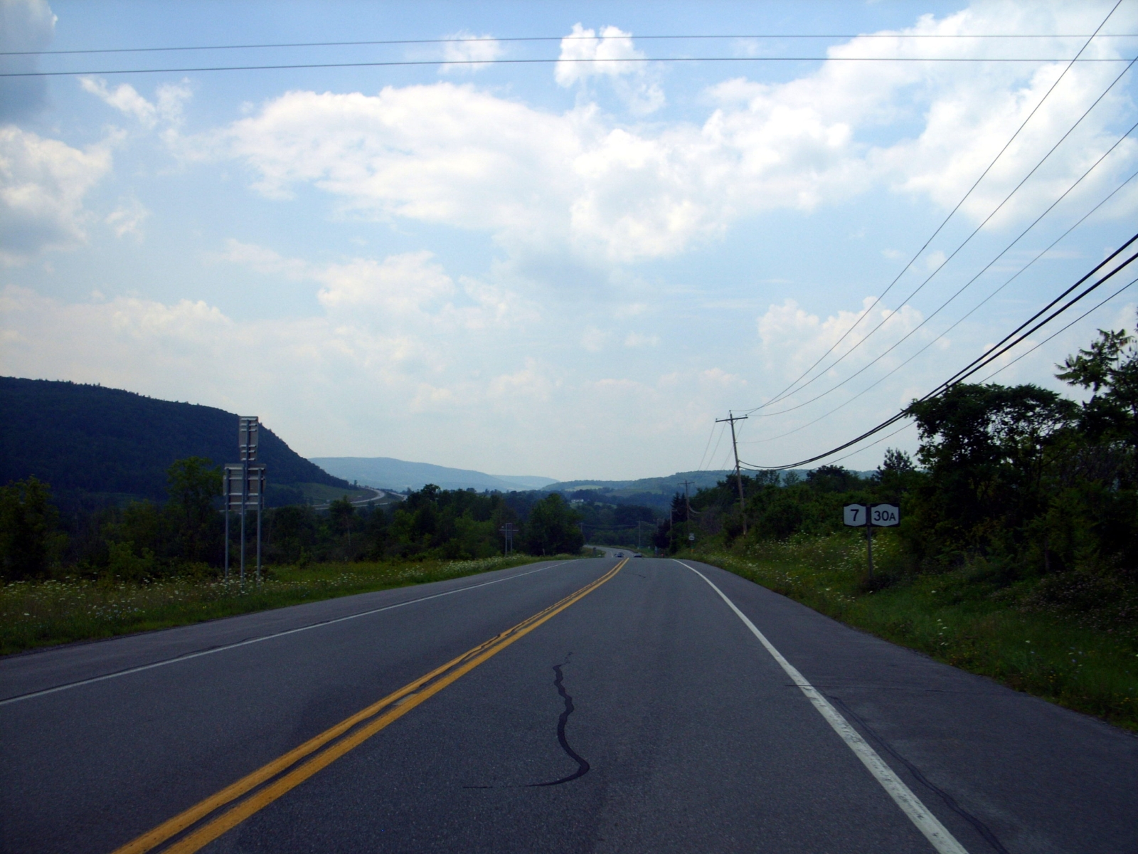
 NY 7 overlaps NY 30A in the town of Schoharie
From Sanitaria Springs eastward, NY 7 and I-88 follow parallel routings through Colesville to Harpursville, where NY 7 overlaps NY 79 for a short distance and intersects NY 235 outside of the community. East of NY 235, NY 7 rejoins the Susquehanna River, following the river (as well as I-88 on the opposite bank) through several riverside villages (including Bainbridge) to Oneonta. West of the city, NY 7 meets NY 23 and joins the route into the heart of Oneonta. Near the eastern edge of the city, NY 23 breaks from NY 7 while NY 7 continues onward in the shadow of I-88 and the Susquehanna River. To the northeast in Colliersville, the Susquehanna separates from NY 7 and is joined by NY 28 while NY 7 continues along the path of Schenevus Creek.
Both NY 7 and I-88 head northeast along the creek through numerous communities to Richmondville, where NY 7 meets NY 10 at an interchange with I-88 near Cobleskill Creek. NY 10 turns east onto NY 7, forming an overlap along the creek to Cobleskill before separating from NY 7 in the center of the village at an intersection with NY 145. NY 145 then overlaps NY 7 east out of the village before separating midway between Cobleskill and Schoharie near Howe Caverns. North of Schoharie, NY 7 briefly overlaps NY 30A across Schoharie Creek before intersecting NY 30 west of the Schoharie-Schenectady County line.
Capital District
In Duanesburg, southwest of Schenectady, NY 7 intersects U.S. Route 20 and meets I-88 once more at exit 24. Both routes continue northeast along Normans Kill into western Schenectady, where I-88 meets NY 7 one final time by way of another interchange before terminating at an interchange with the New York State Thruway (Interstate 90). NY 7, however, passes over the Thruway with no connection and heads east into Rotterdam as Duanesburg Road. In the center of the community, NY 7 turns east onto Curry Road, remaining on the roadway to an interchange with Interstate 890 adjacent to the Schenectady-Albany County line. NY 7 merges with I-890 northward for two exits (creating a wrong-way concurrency) before exiting onto the Crosstown Arterial.
At the end of the arterial in eastern Schenectady, NY 7 becomes the at-grade Troy-Schenectady Road as it heads along the south bank of the Mohawk River into Albany County. Shortly after entering the county and the Town of Colonie, NY 7 leaves the river and progresses southeast toward the hamlet of Latham. Soon after passing the Albany International Airport and prior to entering the center of Latham, NY 7 meets Interstate 87 (the Adirondack Northway) at exit 6. Here, NY 7 joins the Adirondack Northway northward while Troy-Schenectady Road continues east as NY 2. At exit 7, NY 7 separates from the Adirondack Northway and continues east on a freeway known locally as "Alternate Route 7". The route connects to U.S. Route 9 and Interstate 787/NY 787 by way of interchanges prior to crossing over the Hudson River and into Troy over the Collar City Bridge. The route remains a limited-access highway to 8th Street, where it becomes the at-grade Hoosick Street.
NY 7 continues east through Troy, intersecting NY 40 before exiting the city. Past Troy, the land surrounding NY 7 is largely rural as it heads through Pittstown to Hoosick, where it meets and is briefly concurrent to NY 22. Farther east, NY 7 intersects the western end of the Bennington Bypass, a limited-access highway leading to Bennington, Vermont, before crossing into Vermont and becoming Vermont Route 9.
History
Origins and assignment
The history of parts of Route 7 date back to shortly after the settlement of Hoosick in 1688. Hoosick was a part of the Manor of Rensselaerswyck and a public manor road was laid from Rensselaer to the site later of Troy at a ferry crossing, and then to the northeast as far as Hoosick. The section of Route 7 from Troy to Hoosick is that old manor road.[4] The 19th century toll road known as the Troy and Schenectady Turnpike (now the Troy-Schenectady Road) chartered in 1802, connecting the cities of Troy and Schenectady.[5] Another turnpike road, the Troy Turnpike, was established in 1831 and went east from Troy to Bennington, Vermont.[6] The road between Binghamton (at the location known as Chenango Point) through the village of Unadilla to the town of Otego was also an old turnpike road (Unadilla Turnpike) that was chartered in 1806.[7]
The state took over maintenance of certain trunk line highways at the beginning of the 20th century. Most of modern NY 7 was first defined in the 1909 Highway Law (amended in 1911)[8] as State Route 7, which was designated from the Pennsylvania line at Binghamton town to Harpursville, then along the Susquehanna Valley through Oneonta to the town of Schoharie. From there, the legislative route 7 went east via Berne and New Scotland to Albany. The portion of modern NY 7 continuing northeast to Schenectady was part of State Route 7A. The road between Troy and Schenectady was defined as part of State Route 42, while that between Troy and Hoosick was part of State Route 22.
In 1924, when state highways were first publicly signed, most of what is now NY 7 between Binghamton and the Vermont state line was designated as NY 9,[1] continuing the numbering of New England Route 9 in Vermont. Within Albany, NY 9 followed the modern routing of NY 2 through Latham to Troy, where the connection to the modern alignment of NY 7 was made via current U.S. Route 4.[9] In 1927, NY 9 was redesignated as NY 7 to avoid conflict with US 9.[2] The route north of Binghamton remained unchanged in the 1930 renumbering;[10] however, south of Binghamton, NY 7 was extended to the Pennsylvania state line, where it became PA 29.[11][12]
Realignments
Over the years, NY 7 has been realigned to follow different routings in and around the cities it serves. Prior to 1930, NY 7 began at Court Street in Binghamton and followed Chenango Street north into Fenton, where it turned east and continued through Port Crane to the Colesville hamlet of Sanitaria Springs.[13][14] In the 1930 renumbering, NY 7 was extended south to Pennsylvania by way of Court Street, Tompkins Street, and Conklin Avenue.[12][15] NY 7 was realigned slightly by 1947 to follow Robinson Street and Brandywine Avenue between Chenango and Tompkins Streets.[15] Ca. 1961, the Brandywine Highway, a four-lane arterial through Binghamton and Port Dickinson, opened to traffic as a realignment of NY 7.[16][17] The portion of NY 7 between Port Dickinson and Sanitaria Springs was relocated onto a new limited-access highway between 1968 and 1973.[18][19] The segment of Chenango Street between the Binghamton city line and current NY 7 in Port Dickinson (a distance of 1.07 miles or 1.72 kilometres) is now NY 990H, an unsigned reference route.[3][20] The former routing of NY 7 between Port Crane and Sanitaria Springs is now NY 7B.[20]
In Schenectady, it was originally routed along Broadway, State Street, Nott Terrace, and Union Street.[2] It was shifted at some point between 1938 and 1947 to avoid downtown along Curry Road, Altamont Avenue and Brandywine Avenue.[15][21] Meanwhile, the portion of Curry Road between Altamont Avenue and NY 146 was designated as NY 146C in the mid-1930s.[22][23] NY 7 was rerouted ca. 1962 to follow Curry Road east from Altamont Avenue to the new Interstate 890, where NY 7 turned north and followed I-890 to modern exit 7. Here, the route split from I-890 and continued to the junction of Union Street and Rosendale Road east of the city by way of a new arterial. The NY 146C designation was removed from Curry Road as part of the change.[17][24] NY 7's former routing along Altamont Avenue from Curry Road to the Schenectady city line (a length of 0.96 miles or 1.54 kilometres) is now the unsigned NY 911H.[3][20] Prior to the creation of the modern reference route system, Altamont Avenue was designated as NY 951. Reference markers along the route still bear this number.[25]
In 1981, the Collar City Bridge was built, connecting Green Island with Troy in the Capital District.[26] By 1985, construction had begun on the NY 7 freeway, then marked as NY 7 Alternate, between Interstate 87 and Interstate 787 west of Green Island.[27] In 1986, NY 7 "Alternate" opened, becoming part of a realigned NY 7.[26] The old surface alignment was designated as an extension of NY 2.[28]
Suffixed routes
NY 7 currently has two spurs, both located in the Southern Tier. A third formerly existed in the Capital District near Schenectady.
- NY 7A (1.74 miles or 2.80 kilometres) is a spur in the Broome County town of Conklin that connects NY 7 to the Pennsylvania state line. While NY 7 follows a creek valley to the Pennsylvania border, NY 7A continues NY 7's course along the Susquehanna River valley, paralleling US 11 and I-81.[3] When NY 7A was assigned as part of the 1930 renumbering of state highways in New York, it connected to PA 602;[11][12] it now connects to SR 1033, an unsigned quadrant route.[29]
- The NY 7B designation has been assigned to two distinct routes.
- The original NY 7B was an alternate route of NY 7 from Unadilla to Oneonta that was assigned as part of the 1930 renumbering. It overlapped NY 28 from North Franklin to Oneonta.[30][31] On January 1, 1970, the Unadilla – North Franklin portion of NY 7B was renumbered to NY 357.[32]
- The current NY 7B is a 3.71-mile (5.97 km) spur in the Broome County towns of Fenton and Colesville.[3] It follows the former, pre-expressway routing of NY 7 between NY 369 in the hamlet of Port Crane and NY 7 in the hamlet of Sanitaria Springs.[33] Prior to becoming NY 7B in the 1990s,[34][35] it was designated NY 990K, an unsigned reference route.[36]
- NY 7C was a loop off of NY 7 east of Schenectady in the Capital District. The majority of the route was located in Schenectady County; however, the easternmost 40 yards (37 m) of the route was located in Albany County. It began at NY 7 in Niskayuna and proceeded east along Rosendale Road into Colonie, where it ended at NY 7. The route was assigned ca. 1961[17][37] and removed in the late 1960s.[18][38] Ownership and maintenance of NY 7C's former routing in Schenectady County was transferred from the state of New York to the county on April 1, 1980, as part of a highway maintenance swap between the two levels of government.[39] This portion of the route is now designated as County Route 158.[40]
Major intersections
County Location Mile[3] Destinations Notes Broome Conklin 0.00 PA 29Continuation into Pennsylvania 1.26  NY 7A
NY 7ANorthern terminus of NY 7A City of Binghamton 11.11  US 11
US 1111.57  NY 363
Northern terminus of NY 363 11.97 I-81 / NY 17Exit 4 (I-81/NY 17) 14.14  I-88 west
Exit 1 (I-88/NY 7); western terminus of I-88 / NY 7 overlap Fenton 15.90  NY 12A
Exit 2 (I-88/NY 7); eastern terminus of NY 12A Port Crane 18.16  NY 369
Exit 3 (I-88/NY 7) Colesville 21.36 I-88 eastExit 4 (I-88/NY 7); eastern terminus of I-88 / NY 7 overlap Fenton 21.59  NY 7B
NY 7BEastern terminus of NY 7B Colesville 28.56  NY 79 west
Western terminus of NY 7 / NY 79 overlap Nineveh 29.81 NY 79 eastEastern terminus of NY 7 / NY 79 overlap 30.97  NY 235
Southern terminus of NY 235 Chenango Village of Afton 37.27  NY 41
NY 41Village of Bainbridge 43.01  NY 206
Otsego Town of Sidney 47.32 NY 8Town of Unadilla 53.49  NY 357
Western terminus of NY 357 Village of Otego 67.72  NY 205
Town of Oneonta 68.69  NY 23 west
Western terminus of NY 7 / NY 23 overlap 70.95 NY 23 eastEastern terminus of NY 7 / NY 23 overlap Town of Milford 76.00 NY 28Schoharie Village of Richmondville 103.20  NY 10 south
Western terminus of NY 7 / NY 10 overlap Town of Richmondville 105.73 I-88Exit 20 (I-88) Village of Cobleskill 107.70  NY 10 north / NY 145 north
Eastern terminus of NY 7 / NY 10 overlap; western terminus of NY 7 / NY 145 overlap 111.07 NY 145 southEastern terminus of NY 7 / NY 145 overlap Town of Schoharie 115.87  NY 30A north
Western terminus of NY 7 / NY 30A overlap 117.01 NY 30A southEastern terminus of NY 7 / NY 30A overlap 119.06  NY 30
NY 30Schenectady Delanson 123.89  NY 395
Duanesburg 127.24 US 20Princetown 128.23 I-88Exit 24 (I-88) Town of Rotterdam 133.15 
 I-88 to I-90 / Thruway
Exit 25 (I-88) 134.07  NY 337
Southern terminus of NY 337 135.62  NY 159
Eastern terminus of NY 159 136.16  NY 158
Northern terminus of NY 158 138.44 
 NY 146 to I-890 east
Albany Guilderland 139.14 I-890Exit 9 (I-890); southern terminus of I-890 / NY 7 overlap Schenectady Schenectady 140.71 I-890 westExit 7 (I-890); northern terminus of I-890 / NY 7 overlap 141.55 NY 5Niskayuna 142.70 Rosendale Road Former western terminus of NY 7C Albany Town of Colonie 146.39 Rosendale Road / Vly Road Former eastern terminus of NY 7C 149.92  I-87 south / NY 2
Exit 6 (I-87); southern terminus of I-87 / NY 7 overlap; western terminus of NY 2 150.53 I-87 northExit 7 (I-87); northern terminus of I-87 / NY 7 overlap West end of freeway section 151.00 
 US 9 / NY 9R – Latham, Cohoes
154.41  I-787 / NY 787 – Albany, Watervliet, Cohoes
Exits 9E-W (I-787); northern terminus of I-787; southern terminus of NY 787 Rensselaer Troy Downtown Troy Eastbound exit and westbound entrance 155.02 8th Street At-grade intersection East end of freeway section 155.12  NY 40
NY 40Southern terminus of NY 40 Brunswick 158.75  NY 142
Eastern terminus of NY 142 159.78  NY 278
Northern terminus of NY 278 Hoosick 176.02  NY 22 south
Western terminus of NY 7 / NY 22 overlap 176.35 NY 22 northEastern terminus of NY 7 / NY 22 overlap 179.57  To VT 279 (NY 915G)
180.47 VT 9Continuation into Vermont 1.000 mi = 1.609 km; 1.000 km = 0.621 mi References
- ^ a b "New York's Main Highways Designated by Numbers". The New York Times: p. XX9. December 21, 1924.
- ^ a b c Automobile Blue Book. 1 (1927 ed.). Chicago: Automobile Blue Book, Inc. 1927. This edition shows U.S. Routes as they were first officially signed in 1927.
- ^ a b c d e f "2008 Traffic Volume Report for New York State" (PDF). New York State Department of Transportation. June 16, 2009. pp. 16–19, 262, 291. https://www.nysdot.gov/divisions/engineering/technical-services/hds-respository/NYSDOT%20TVR%202008%20by%20Route.pdf. Retrieved January 30, 2010.
- ^ Barnett, J. N. (1881). History of Gilead Evangelical Lutheran Church, Centre Brunswick, Rensselaer Co., N. Y., and its vicinity. Fort Wayne, Indiana: Gazette Co.. pp. 10.
- ^ Howell, George Rogers (1886). History of the County of Schenectady, N.Y., from 1662 to 1886. W.W. Munsell and Co. Publishers.
- ^ Anderson, George Baker (1897). "History of Troy, New York". D. Mason and Co. Publishers. http://history.rays-place.com/ny/ren-troy-ny1.htm. Retrieved November 24, 2007.
- ^ New York State Legislature (1806). "98". Laws of the State of New York. 4. Albany, New York: Websters and Skinner. p. 448. http://books.google.com/books?id=iWQ4AAAAIAAJ&pg=PA448#v=onepage&q&f=false. Retrieved May 4, 2010.
- ^ State of New York Commission of Highways (1919). The Highway Law. Albany, New York: J. B. Lyon Company. http://books.google.com/books?id=hZ4AAAAAMAAJ. Retrieved May 4, 2010.
- ^ Rand McNally (1926). Rand McNally Road Atlas (Map). http://www.broermapsonline.org/members/NorthAmerica/UnitedStates/Midatlantic/NewYork/unitedstates1926ra_009.html. Retrieved September 12, 2007.
- ^ Dickinson, Leon A. (January 12, 1930). "New Signs for State Highways". The New York Times: p. 136.
- ^ a b Automobile Blue Book Inc. (1929). Automobile Blue Book (Map). http://www.broermapsonline.org/members/NorthAmerica/UnitedStates/Midatlantic/Pennsylvania/bluebook1929_015.html. Retrieved September 12, 2007.
- ^ a b c Pennsylvania Department of Highways (1930) (PDF). Tourist Map of Pennsylvania (Map). ftp://ftp.dot.state.pa.us/public/pdf/BPR_pdf_files/Maps/Statewide/Historic_OTMs/1930fr.pdf. Retrieved September 12, 2007.
- ^ Automobile Blue Book. 3. Automobile Blue Book Inc.. 1929. p. 18. http://www.broermapsonline.org/members/NorthAmerica/UnitedStates/Midatlantic/NewYork/bluebook1929_014.html. Retrieved December 5, 2009.
- ^ Standard Oil Company of New York (1929). New York in Soconyland (Map). Cartography by General Drafting.
- ^ a b c State of New York Department of Public Works. Official Highway Map of New York State (Map). Cartography by General Drafting (1947–48 ed.).
- ^ Gulf (1960). New York and New Jersey Tourgide Map (Map). Cartography by Rand McNally and Company.
- ^ a b c Sunoco (1961). New York and Metropolitan New York (Map). Cartography by H.M. Gousha Company (1961–62 ed.).
- ^ a b Esso (1968). New York (Map). Cartography by General Drafting (1969–70 ed.).
- ^ Sunoco (1973). New York (Map). Cartography by H.M. Gousha Company (1973 ed.).
- ^ a b c New York State Department of Transportation (January 2009) (PDF). Official Description of Highway Touring Routes, Bicycling Touring Routes, Scenic Byways, & Commemorative/Memorial Designations in New York State. https://www.nysdot.gov/divisions/operating/oom/transportation-systems/repository/2009%20tour-bk.pdf. Retrieved December 6, 2009.
- ^ Thibodeau, William A. (1938). The ALA Green Book (1938–39 ed.). Automobile Legal Association.
- ^ Texas Oil Company (1934). Road Map of New York (Map). Cartography by Rand McNally and Company.
- ^ Standard Oil Company (1936). New York (Map). Cartography by General Drafting.
- ^ Esso (1962). New York with Sight-Seeing Guide (Map). Cartography by General Drafting.
- ^ Perry, N.W.. "Reference Routes, Region 1". Empire State Roads. http://www.empirestateroads.com/sr/refroute1.html. Retrieved December 6, 2009.
- ^ a b National Bridge Inventory, a database compiled by the United States Department of Transportation Federal Highway Administration, available at www.nationalbridges.com. Accessed September 12, 2007.
- ^ Rand McNally (1985). New York (Map). ISBN 0-528-91040-X.
- ^ DeLorme Mapping (1990). Upstate New York City Street Maps (Map). 1" = 1/2 mile. Cartography by DeLorme Mapping (1st ed.). p. 39, section E1. ISBN 0-89933-300-1.
- ^ Pennsylvania Department of Transportation (2010) (PDF). General Highway Map – Susquehanna County, Pennsylvania (Map). ftp://ftp.dot.state.pa.us/public/pdf/BPR_pdf_files/Maps/GHS/Roadnames/susquehanna_GHSN.PDF. Retrieved May 4, 2010.
- ^ Standard Oil Company of New York (1930). Road Map of New York (Map). Cartography by General Drafting.
- ^ Automobile Legal Association (ALA) Automobile Green Book, 1930–31 and 1931–32 editions, (Scarborough Motor Guide Co., Boston, 1930 and 1931). The 1930–31 edition shows New York state routes prior to the 1930 renumbering
- ^ State of New York Department of Transportation (January 1, 1970) (PDF). Official Description of Touring Routes in New York State. http://www.greaternyroads.info/pdfs/state70.pdf. Retrieved January 3, 2010.
- ^ Sinsabaugh, Mark. "New York State Route 7B". New York Routes. http://www.gribblenation.net/nyroutes/ind/001_009.htm#007b. Retrieved November 26, 2007.
- ^ New York State Department of Transportation (1994). Chenango Forks Digital Raster Quadrangle (Map). 1:24,000. http://www.nysgis.state.ny.us/gisdata/quads/drg24/dotpreview/index.cfm?code=w32. Retrieved November 5, 2010.
- ^ National Geographic Maps (2001). National Geographic Road Atlas (Map). Cartography by Mapquest. p. 77, section Q15. ISBN 1572625473.
- ^ Perry, N.W.. "NYS Reference Routes: Region 9". Empire State Roads. http://www.empirestateroads.com/sr/refroute9.html. Retrieved November 26, 2007.
- ^ Gulf (1960). New York and New Jersey Tourgide Map (Map). Cartography by Rand McNally and Company.
- ^ State of New York Department of Transportation (January 1, 1970) (PDF). Official Description of Touring Routes in New York State. http://www.greaternyroads.info/pdfs/state70.pdf. Retrieved December 5, 2009.
- ^ New York State Legislature. "New York State Highway Law § 341". http://public.leginfo.state.ny.us/menugetf.cgi?COMMONQUERY=LAWS. Retrieved December 5, 2009.
- ^ New York State Department of Transportation (1992). Niskayuna Digital Raster Quadrangle (Map). 1:24,000. http://www.nysgis.state.ny.us/gisdata/quads/drg24/dotpreview/index.cfm?code=r48. Retrieved December 5, 2009.
External links
Categories:- State highways in New York
- Transportation in Broome County, New York
- Transportation in Chenango County, New York
- Transportation in Otsego County, New York
- Transportation in Schoharie County, New York
- Transportation in Schenectady County, New York
- Transportation in Albany County, New York
- Transportation in Rensselaer County, New York
- Limited-access roads in New York


Wikimedia Foundation. 2010.