- New York State Route 146
-
NYS Route 146

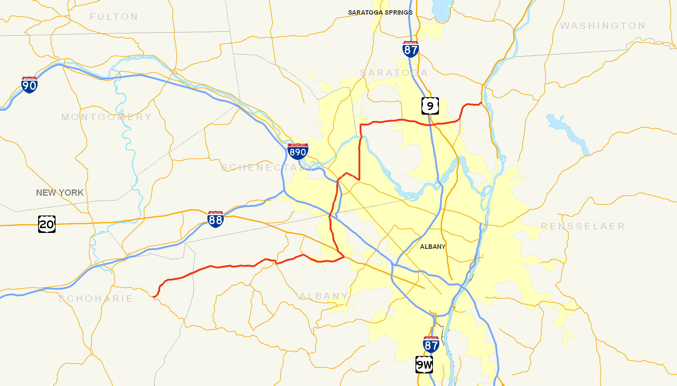
Map of the Capital District with NY 146 highlighted in redRoute information Maintained by NYSDOT, Schenectady County, and the city of Schenectady Length: 42.80 mi[2] (68.88 km) Existed: 1930[1] – present Major junctions West end:  NY 443 in Wright
 US 20 in Guilderland
 I-890 in Rotterdam
 NY 5 in Schenectady
 I-87 in Clifton Park
East end: 
 US 4 / NY 32 in Halfmoon
Location Counties: Schoharie, Albany, Schenectady, Saratoga Highway system Numbered highways in New York
Interstate • U.S. • N.Y. (former) • Reference • County←  NY 145
NY 146A  →
→New York State Route 146 (NY 146) is a state highway in the Capital District of New York in the United States. It extends for 43 miles (69 km) from Gallupville at NY 443 to near Mechanicville at U.S. Route 4 (US 4) and NY 32. NY 146 is a major thoroughfare in the city of Schenectady, just outside of Albany. Most of the route follows an east–west alignment; however, the middle third of the route between Guilderland and Clifton Park runs in a more north–south manner in order to serve Schenectady. At one time, NY 146 had three spur routes; only one—NY 146A—still exists.
NY 146 was assigned as part of the 1930 renumbering of state highways in New York. At the time, NY 146 began at modern NY 443 in Berne and followed what is now NY 156 northeast to Altamont while modern NY 146 west of Altamont was part of NY 156. The alignments of the two routes were flipped in the late 1930s. Other minor realignments have occurred since, most notably near Mechanicville.
Contents
Route description
 NY 146 westbound approaching its western terminus at NY 443 in Gallupville
Schoharie and Albany Counties
NY 146 begins at a T-intersection with NY 443 in Gallupville, a hamlet within the town of Wright.[3] The highway spends only 4.24 miles (6.82 km) in Schoharie County before passing into neighboring Albany County.[2] Along this stretch, NY 143 has an intersection with County Route 26 (CR 26, named Larry Hill Road) just over 1 mile (1.6 km) from NY 443.[3] After crossing into Albany County, NY 146 turns eastward and heads toward Albany, the capital of New York. In the Knox hamlet of West, NY 146 intersects CR 259. As NY 146 reaches the hamlet of East a short time later, it meets CRs 252, 260, 261, and 262 in quick succession. NY 146 continues eastward, passing through a rural area of Albany County on its way to the town of Guilderland and the village of Altamont contained within.[4]
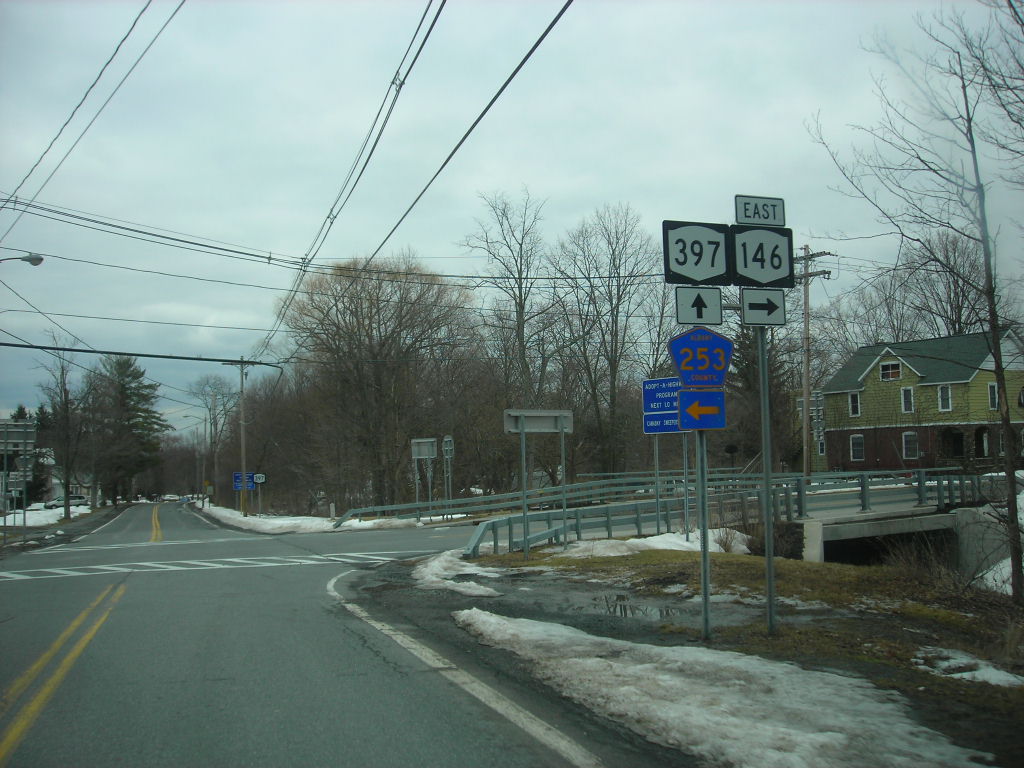
 NY 146 at the intersection with NY 397 and Albany CR 253 in Altamont
NY 146 enters Altamont from the west on Western Avenue. At Maple Avenue, NY 146 turns south to follow that street for two blocks while NY 397 begins on the road that NY 146 vacates. NY 146 leaves Maple Avenue at Main Street—the latter of which connects to NY 156 one block to the west—and follows Main Street eastward out of the village.[4] After leaving Altamont, NY 146 continues for about 3 miles (5 km) through a lightly populated portion of Guilderland before intersecting with the southern terminus of NY 158. The route progresses onward, intersecting CRs 201 and 202 and passing over the CSX Transportation-owned Selkirk Subdivision railroad line and Normans Kill before meeting US 20 at Hartmans Corners. NY 146 joins US 20 for about 0.7 miles (1.1 km) northwestward to McCormack Corners, where NY 146 leaves US 20 and heads northward toward Schenectady County. The route passes over the New York State Thruway (Interstate 90 or I-90) just south of the county line.[5]
Schenectady and Saratoga Counties
At the county line, Fort Hunter Road (CR 71) leaves to the left just before an interchange with I-890. NY 146 continues on through Rotterdam, meeting NY 7 at a junction about 2 miles (3.2 km) south of Schenectady. The route continues on, paralleling I-890 into the Schenectady city limits at Glengary Avenue.[6] Here, maintenance of the route shifts from the New York State Department of Transportation (NYSDOT) to the city of Schenectady.[7] Five blocks later, NY 146 intersects with Altamont Avenue (unsigned NY 911H) just before crossing over I-890 and entering Schenectady's downtown district.[6] In downtown Schenectady, NY 146 follows Brandywine Avenue northeastward past an intersection with NY 5 (State Street) to Union Street, where the route turns to follow Union eastward out of the city.[8] Upon crossing into Niskayuna, ownership of the route shifts to Schenectady County, which maintains the roadway as CR 159. CR 159 ends five blocks later at Balltown Road (unsigned NY 914T). NY 146 turns north onto Balltown, becoming NYSDOT maintained once more in the process.[7]
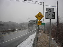 NY 146 crossing over the Mohawk River
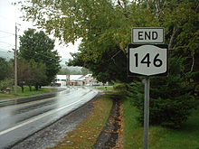
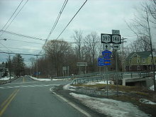
3.5 miles (5.6 km) north of Union Street, NY 146 crosses over the Mohawk River and enters Saratoga County. On the north bank of the river in Clifton Park, CRs 88 and 91 terminate at NY 146 in opposite directions. This portion of CR 91 was once part of NY 146B, a former spur of NY 146.[8] NY 146 turns eastward three-quarters of a mile (1.2 km) later at a junction with Glenridge Road (unsigned NY 914V) and CR 110. Just outside of Clifton Park Center, NY 146 meets NY 146A, the lone remaining spur of NY 146. Soon after the NY 146A intersection, the route encounters I-87 (the Adirondack Northway) at exit 9 and intersects US 9.[9] About 2 miles (3.2 km) east of US 9 in Halfmoon, NY 236 merges in from the south. NY 146 veers northward at this junction, then breaks eastward a mile (1.6 km) later at an intersection with CR 1345 southwest of Mechanicville. NY 146 comes to an end soon afterward at US 4 and NY 32 south of Mechanicville on the banks of the Hudson River.[10]
History
NY 146 was assigned as part of the 1930 renumbering of state highways in New York and originally extended from NY 43 (now NY 443) in Berne northeast through Schenectady to US 4 and NY 32 in Mechanicville. The portion of the route northeast of Altamont generally followed its modern alignment; however, west of Altamont, NY 146 followed what is now NY 156. At the time, the portion of modern NY 146 west of Altamont was part of NY 156.[1][11] The alignments of NY 146 and NY 156 west of Altamont were flipped ca. 1940. Although most of former NY 146 west of Altamont became part of NY 156,[12][13] a one-block section of Main Street within the village did not and is now designated as NY 912C, an unsigned reference route. The 0.08-mile (0.13 km) route serves as a connector between NY 156 and NY 146, which do not meet despite both highways using Main Street as an entrance to the village.[2] Both NY 156 and NY 146 are marked with signs directing traffic to the other route by way of this one block of Main Street.
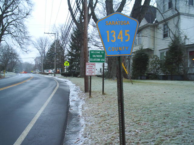
 CR 1345 entering the town of Halfmoon
In Schenectady, NY 146 was originally routed on Union, Jay, and Nott Streets and Van Vranken Avenue through the northern portion of the city.[14] It was realigned between 1938 and 1947 to bypass the northern part of the city on Balltown Road.[15][16] The New York State Department of Transportation (NYSDOT) has reserved the NY 646 designation for the former routing of NY 146 through Schenectady; however, there is no timetable for its assignment.[17] In Halfmoon, NY 146 was initially routed on Pruyn Hill Road and South Street in the vicinity of Mechanicville.[11] The route was altered in the late 1940s to follow a new highway that bypassed Mechanicville to the south.[16][18] The portion of NY 146's former routing outside of the Mechanicville city limits is now designated and signed as CR 1345, reflecting the number of the legislative state highway (SH 1345) that makes up the portion of NY 146 in Halfmoon and thus once followed Pruyn Hill Road.[19] CR 1345 is the only signed four-digit county route in New York.[20]
Future
The New York State Department of Transportation (NYSDOT) has identified the NY 146 corridor from Riverview Road to Glen Ridge Road as in need of future improvements. Intersection improvements are scheduled at the NY 146 / Aqueduct Road / Williams Road and NY 146 / Riverview Road intersections. This part of the project will be built in 2008 and is to include new turn lanes at each intersection. To the south, the Rexford Bridge over the Mohawk River and the surrounding roadway will be improved in stages, with completion expected by 2017. The objective of these projects is to improve highway capacity and safety along the corridor.[21]
Suffixed routes
As many as three spurs once led from NY 146; however, two no longer exist.
- NY 146A is a short 6.38-mile (10.27 km) road in Clifton Park and Ballston Lake that connects NY 146 in Clifton Park to NY 50 in Ballston Lake.[2] It was assigned ca. 1932.[14][22]
- NY 146B was a spur in the town of Clifton Park. It began at NY 146 in the hamlet of Rexford and ended in the hamlet of Groom Corners. It was assigned ca. 1932[14][22] and removed ca. 1965.[23][24] Its routing is now part of CR 91.[7][25]
- NY 146C was a connector between NY 7 and NY 146 in Rotterdam. The route was assigned in the mid-1930s[26][27] and replaced with a rerouted NY 7 ca. 1962.[28][29]
Major intersections
County Location Mile[2] Destinations Notes Schoharie Wright 0.00 NY 443Albany Altamont 11.37  NY 397
Southern terminus of NY 397 11.70  To NY 156 via Main Street (NY 912C)
Guilderland 14.06  NY 158
Southern terminus of NY 158 17.71 US 20 eastEastern terminus of US 20 / NY 146 overlap 18.39 US 20 westWestern terminus of US 20 / NY 146 overlap Schenectady Town of Rotterdam 21.72 
 I-890 east to I-90 / Thruway
Exit 9 (I-890) to exit 25 (I-90 / Thruway) 22.08  NY 7 to I-890 west
Schenectady 24.72 NY 5Saratoga Clifton Park  CR 91 (Riverview Road)
Hamlet of Rexford; former western terminus of NY 146B 35.07 NY 146ASouthern terminus of NY 146A 37.45 I-87Exit 9 (I-87) Halfmoon 37.77  US 9
US 940.03  NY 236
Northern terminus of NY 236 42.80 US 4 / NY 321.000 mi = 1.609 km; 1.000 km = 0.621 mi References
- ^ a b Automobile Legal Association (ALA) Automobile Green Book, 1930/31 and 1931/32 editions, (Scarborough Motor Guide Co., Boston, 1930 and 1931). The 1930/31 edition shows New York state routes prior to the 1930 renumbering
- ^ a b c d e "2008 Traffic Data Report for New York State" (PDF). New York State Department of Transportation. June 16, 2009. pp. 251–252, 342. https://www.nysdot.gov/divisions/engineering/technical-services/hds-respository/NYSDOT_Traffic_Data_Report_2008.pdf. Retrieved December 8, 2009.
- ^ a b Google, Inc. Google Maps – overview map of NY 146 in Gallupville (Map). Cartography by Google, Inc. http://maps.google.com/maps?hl=en&q=NY+Route+146,+Gallupville&um=1&ie=UTF-8&sa=N&tab=wl. Retrieved September 19, 2007.
- ^ a b Google, Inc. Google Maps – overview map of NY 146 in Altamont (Map). Cartography by Google, Inc. http://maps.google.com/maps?hl=en&q=NY+Route+146,+Altamont&um=1&ie=UTF-8&sa=N&tab=wl. Retrieved September 19, 2007.
- ^ Google, Inc. Google Maps – overview map of NY 146 in Guilderland (Map). Cartography by Google, Inc. http://maps.google.com/maps?hl=en&q=NY+Route+146,+Guilderland&um=1&ie=UTF-8&sa=N&tab=wl. Retrieved September 19, 2007.
- ^ a b Google, Inc. Google Maps – overview map of NY 146 in Schenectady (Map). Cartography by Google, Inc. http://maps.google.com/maps?hl=en&q=NY+Route+146,+Schenectady&um=1&ie=UTF-8&sa=N&tab=wl. Retrieved September 19, 2007.
- ^ a b c New York State Department of Transportation (1993). Schenectady Digital Raster Quadrangle (Map). 1:24,000. http://www.nysgis.state.ny.us/gisdata/quads/drg24/dotpreview/index.cfm?code=r47. Retrieved December 12, 2009.
- ^ a b Google, Inc. Google Maps – overview map of NY 146 in Rexford (Map). Cartography by Google, Inc. http://maps.google.com/maps?hl=en&q=NY+Route+146,+Rexford&um=1&ie=UTF-8&sa=N&tab=wl. Retrieved September 19, 2007.
- ^ Google, Inc. Google Maps – overview map of NY 146 in Clifton Park (Map). Cartography by Google, Inc. http://maps.google.com/maps?hl=en&q=NY+Route+146,+Clifton+Park&um=1&ie=UTF-8&sa=N&tab=wl. Retrieved September 19, 2007.
- ^ Google, Inc. Google Maps – overview map of NY 146 in Mechanicville (Map). Cartography by Google, Inc. http://maps.google.com/maps?ie=UTF8&ll=42.878543,-73.716545&spn=0.044908,0.11467&z=14. Retrieved April 7, 2008.
- ^ a b Standard Oil Company of New York (1930). Road Map of New York (Map). Cartography by General Drafting.
- ^ Standard Oil Company (1939). New York (Map). Cartography by General Drafting.
- ^ Gulf Oil Company (1940). New York Info-Map (Map). Cartography by Rand McNally and Company.
- ^ a b c Texas Oil Company (1932). Texaco Road Map – New York (Map). Cartography by Rand McNally and Company.
- ^ Thibodeau, William A. (1938). The ALA Green Book (1938–39 ed.). Automobile Legal Association.
- ^ a b State of New York Department of Public Works. Official Highway Map of New York State (Map). Cartography by General Drafting (1947–48 ed.).
- ^ New York State Department of Transportation (January 2009) (PDF). Official Description of Highway Touring Routes, Bicycling Touring Routes, Scenic Byways, & Commemorative/Memorial Designations in New York State. https://www.nysdot.gov/divisions/operating/oom/transportation-systems/repository/2009%20tour-bk.pdf. Retrieved July 16, 2009.
- ^ Esso (1949). New York (Map). Cartography by General Drafting (1950 ed.).
- ^ New York State Department of Transportation (1992). Mechanicville Digital Raster Quadrangle (Map). 1:24,000. http://www.nysgis.state.ny.us/gisdata/quads/drg24/dotpreview/index.cfm?code=q49. Retrieved December 12, 2009.
- ^ Perry, N.W.. "Saratoga County Roads". Empire State Roads. http://www.empirestateroads.com/cr/crsaratoga.html. Retrieved December 12, 2009.
- ^ New York State Department of Transportation. "Route 146 Riverview Rd. to Glenridge Rd.". https://www.nysdot.gov/regional-offices/region1/projects/balltown-rexford. Retrieved September 21, 2007.
- ^ a b Kendall Refining Company (1931). New York (Map). Cartography by H.M. Gousha Company.
- ^ Standard Oil Company (1964–65). New York State Map (Map).
- ^ Mobil Service (1965). New York (Map). Cartography by Rand McNally.
- ^ New York State Department of Transportation (1992). Niskayuna Digital Raster Quadrangle (Map). 1:24,000. http://www.nysgis.state.ny.us/gisdata/quads/drg24/dotpreview/index.cfm?code=r48. Retrieved December 12, 2009.
- ^ Texas Oil Company (1934). Road Map of New York (Map). Cartography by Rand McNally and Company.
- ^ Standard Oil Company (1936). New York (Map). Cartography by General Drafting.
- ^ Sunoco (1961). New York and Metropolitan New York (Map). Cartography by H.M. Gousha Company (1961–62 ed.).
- ^ Esso (1962). New York with Sight-Seeing Guide (Map). Cartography by General Drafting.
External links
Categories:- State highways in New York
- Transportation in Schoharie County, New York
- Transportation in Schenectady County, New York
- Transportation in Saratoga County, New York
- Transportation in Albany County, New York


Wikimedia Foundation. 2010.