- New York State Route 30
-
"NY 30" redirects here. NY 30 may also refer to New York's 30th congressional district.This article is about the current alignment of NY 30. For the former alignment of NY 30 in eastern New York, see New York State Route 30 (1924–1930).
NYS Route 30

Map of New York with NY 30 highlighted in redRoute information Maintained by NYSDOT and the city of Amsterdam Length: 300.71 mi[2] (483.95 km) Existed: 1930[1] – present Major junctions South end:  NY 17 in Hancock
 NY 28 at Pepacton Reservoir
 US 20 in Duanesburg

 I-90 / Thruway in Amsterdam
 NY 8 in Speculator
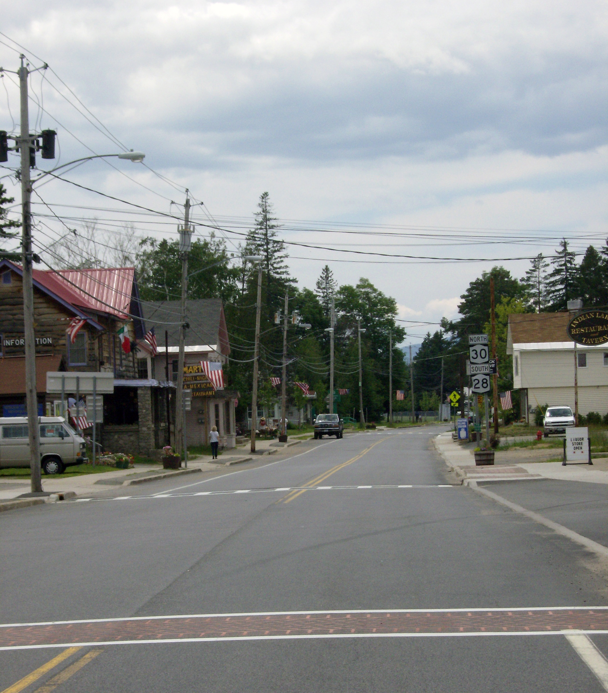
NY 28 at Indian Lake
 US 11 in Malone
North end:  Route 138 in Constable
Location Counties: Delaware, Schoharie, Schenectady, Montgomery, Fulton, Hamilton, Franklin, St. Lawrence Highway system Numbered highways in New York
Interstate • U.S. • N.Y. (former) • Reference • County←  NY 29A
NY 30A  →
→New York State Route 30 (NY 30) is a state highway in the central part of New York in the United States. It extends for 300.71 miles (483.95 km) from an interchange with NY 17 in the Southern Tier to the Canadian border in the state's North Country, where it continues into Quebec as Route 138. On a regional level, the route serves to connect the Catskill Park to the Adirondack Park. In the latter, NY 30 is known as the Adirondack Trail. Aside from the state parks, the route serves the city of Amsterdam (where it meets the New York State Thruway) and several villages.
NY 30 was assigned in the 1930 renumbering of state highways in New York to most of its modern routing south of Wells, replacing a series of designations that had been assigned to the highway in the 1920s. The portion of what is now NY 30 north of Speculator was initially part of NY 10. When that route was truncated to Arietta ca. 1960, NY 30 was extended northward over NY 10's former alignment by way of an overlap with NY 8.
Contents
Route description
The New York State Department of Transportation (NYSDOT) maintains all but 0.97 miles (1.56 km) of NY 30's 301-mile (484 km) alignment. The only section not maintained by the state is located in the city of Amsterdam, where the route is locally maintained from Prospect Street (two blocks north of NY 67) to the northern city line.[3]
Hancock to Schoharie
NY 30 begins at an interchange with NY 17 in the town of Hancock adjacent to the confluence of the East Branch of the Delaware River and the Beaverkill River. The route follows the East Branch northeast to Downsville, where it meets NY 206. NY 206 follows NY 30 across the East Branch into Catskill Park, where the routes split near Brock Mountain. NY 30 exits the park and crosses over the river once more soon after. Near Margaretville, NY 30 briefly overlaps NY 28 before turning northward toward Roxbury, where the route passes the John Burroughs Memorial State Historic Site.[4] New York Governor David Paterson designated the stretch of NY 30 within Margaretville the "David C. Brinkerhoff Memorial Highway", after the New York State Trooper who was slain in pursuit of Travis Trimm near the village on April 25, 2007.[5]
 NY 30 begins its 300-mile (483 km) journey here at NY 17 in Hancock.
From Roxbury, NY 30 follows the East Branch to Grand Gorge in northeastern Delaware County, where the East Branch comes to an end amidst the mountains. NY 30, meanwhile, intersects NY 23 in the center of the hamlet.[4]
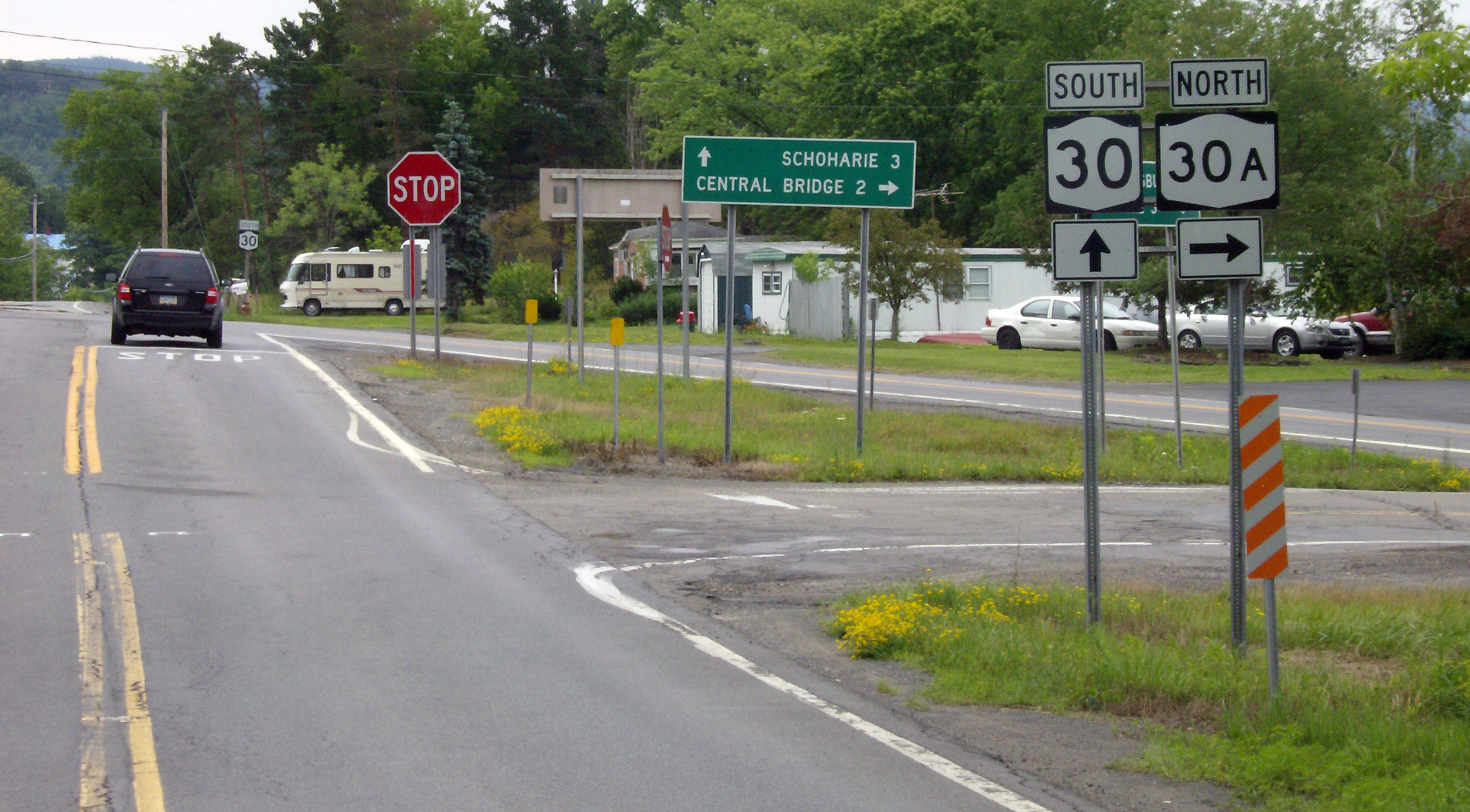
 NY 30 southbound, traffic stopping at the southern terminus of NY 30A, which does not stop.
North of Grand Gorge, NY 30 crosses into Schoharie County and intersects NY 990V, one of four reference routes in New York erroneously signed as a touring route, near the northeastern edge of the Schoharie Reservoir in Gilboa. From NY 990V northward, NY 30 follows the Schoharie Creek through Schoharie County to Middleburgh, where it intersects NY 145. To the north in Schoharie, NY 30 meets NY 443 before splitting into NY 30 and NY 30A north of the village, with Schoharie Creek largely following NY 30A. While NY 30A connects to Interstate 88 (I-88) by way of an interchange a short distance to the north, NY 30 has no connection to the freeway. Just past I-88, NY 30 intersects NY 7. Shortly after passing NY 7, NY 30 enters Schenectady County.[4]
Schoharie to Adirondack Park
In Schenectady County, Schoharie Creek breaks from NY 30A and returns to the vicinity of NY 30 as it intersects U.S. Route 20 (US 20) in Esperance. From Esperance northward, the creek becomes roughly equidistant from both NY 30 and NY 30A as all three entities cross into Montgomery County. Near the northeastern corner of the county, NY 30 enters the city of Amsterdam. The route meets the New York State Thruway (I-90) and NY 5S via separate interchanges before heading downhill as a four-lane divided highway approaching the Mohawk River (here part of the Erie Canal). Historically, the bridge over the river was a straight line to Market Street, which is visible as one approaches northbound. Segments of downtown Market Street remain in use today. With the 1977 creation of the Amsterdam Mall, NY 30, together with NY 5 and NY 67, were re-routed onto splits.[6][7] After the splits rejoin, NY 30 continues on Market Street and leaves the city and, for all purposes, the county.[4]
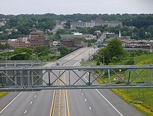 NY 30 approaching Amsterdam with Market Street hill visible in the background
In adjacent Fulton County, NY 30 crosses NY 29 near Broadalbin, then curves gently to the east after an intersection with County Route 155 (CR 155), a historical routing of NY 29. 0.25 miles (0.40 km), NY 30 turns left toward Mayfield; CR 155 continues eastward. The concurrency between the two routes is unsigned.[4]
NY 30 historically followed School Street through the village of Mayfield. The new routing has it heading toward Riceville, where NY 30A rejoins NY 30. Here, the Adirondack Trail begins as NY 30 turns right, following the right-of-way of NY 30A into Adirondack Park shortly before entering Mayfield.[4]
Adirondack Park and Franklin County
NY 30 runs through the Adirondacks, accessing communities such as Speculator, Blue Mountain Lake, and Tupper Lake as a scenic byway named the Adirondack Trail.[4][8] From Wells to Speculator, NY 30 is concurrent to NY 8, then with NY 28 from Indian Lake to Blue Mountain Lake. Between Blue Mountain Lake and Long Lake, NY 30 is concurrent with the eastern third of NY 28N.[4]
Near Tupper Lake, it skirts the boundary between Franklin and Saint Lawrence for a considerable distance before entering Tupper Lake and intersecting NY 3. The two routes overlap to Harrietstown, where NY 30 splits from NY 3 and heads north along a series of lakes, including Upper Saranac Lake and Meacham Lake. North of Duane, NY 30 exits Adirondack Park and heads north towards Malone. Within the village, NY 30 briefly overlaps US 11. The Adirondack Trail ends at the east end of the overlap. The route continues north out of the village to the Canadian border in Constable, where it becomes Route 138 upon entering Quebec.[4]
History
Old roads
Route 30 made up part of the privately-owned Middletown and Roxbury Turnpike. The turnpike, which accessed the villages of Middletown and Roxbury, was created in 1808.[9] The highway was about 23 miles (37 km) long, as that is the current stretch of Route 30 from Middletown to Roxbury.[2]
The stretch of Route 30 from Middleburgh to Schoharie was also once part of the Middleburgh and Schoharie Plank Road.[9]
Designation
Prior to 1930, the modern routing of NY 30 carried a large number of designations. Between Margaretville and Grand Gorge in the town of Roxbury, what is now NY 30 was designated as part of NY 19. From Mayfield north to Malone, most of the current routing of NY 30 carried a designation. The portion from the modern junction of NY 30 and NY 30A in Mayfield to Speculator was part of NY 54. From Speculator to Indian Lake, NY 30 was the northernmost segment of NY 80.[1] Between Indian Lake and Long Lake, NY 30 comprised the western half of NY 10A.[10] Past Long Lake, NY 30 was part of NY 10 north to the modern junction of NY 30 and NY 186 west of Harrietstown. From NY 186 to modern NY 86 in Paul Smiths, the present alignment of NY 30 was unnumbered. Between Paul Smiths and Malone, NY 30 was part of NY 3. The remainder of NY 30 was unnumbered.[1]
In the 1930 renumbering, NY 30 was largely assigned to its current alignment between the Hancock hamlet of East Branch and Wells, where it terminated at NY 8. Past Wells, the modern alignment of NY 30 was designated as NY 8 to Spectator and as NY 10 north to the Canadian border.[1][11] NY 10 was truncated southward to NY 8 in Arietta ca. 1960, at which time NY 30 was extended north to Quebec along the former alignment of NY 10.[12][13]
Realignments
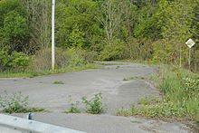 One of the entrances of the Old Route 30 trail
NY 30 has been realigned in two areas along its routing. The first realignment was in the Schoharie Valley near the hamlets of Breakabeen and Fultonham. NY 30 was originally routed along the base of Toepath Mountain near Fultonham and along a pair of village streets in Breakabeen. In the 1950s, a proposal was made to reroute NY 30 onto a new routing in the base of the valley surrounding Schoharie Creek.[citation needed] The proposal was approved, and the new alignment of NY 30 opened ca. 1970.[14][15] The former routing of NY 30 from Max V. Shaul State Park near Breakabeen to Fultonham, still visible from the modern alignment of the route, was closed to the public and guardrails were installed to stop motor traffic from using the route. However, biking and walking was still allowed, and the old highway is now a 1.5-mile (2.4 km) long trail known as "Old Route 30". The trail is not maintained; thus, the quality of the blacktop along Old Route 30 has deteriorated over the years. There are significant potholes and overhanging trees, but the path is still traversable.
The second realignment of NY 30 was in the vicinity of the village of Northville. NY 30 originally entered the village by way of Bridge Street and followed Bridge, Main, and Reed Streets through the village. It continued along the eastern bank of the Great Sacandaga Lake on what is now Old State Road and Old Northville Road and rejoined its modern alignment in the town of Hope.[11] The route was realigned ca. 1961 to follow a new highway along the western lakeshore, bypassing Northville entirely.[13][16] The portion of Bridge Street from NY 30 to the Northville village line remains state-maintained as NY 920H, an unsigned reference route 0.23 miles (0.37 km) in length.[2] Farther north, the portion of Old Northville Road from the Fulton–Hamilton county line to its junction with NY 30 is maintained by Hamilton County as CR 15.[17]
NY 30A

NY 30A (34.86 miles or 56.10 kilometres) is a loop of NY 30, running west of NY 30 from north of Schoharie to south of Mayfield through Fultonville, Fonda, Johnstown, and Gloversville.[2] It was assigned in the late 1950s.[13][18]
Major intersections
County Location Mile[2] Destinations Notes Delaware Town of Hancock 0.00 NY 17Exit 90 (NY 17) Colchester 14.92  NY 206 west
Hamlet of Downsville; western terminus of NY 30 / NY 206 overlap 18.02 NY 206 eastEastern terminus of NY 30 / NY 206 overlap Middletown 37.92 NY 28 northSouthern terminus of NY 28 / NY 30 overlap Margaretville 41.36 NY 28 southNorthern terminus of NY 28 / NY 30 overlap Roxbury 60.42  NY 23
NY 23Hamlet of Grand Gorge Schoharie Gilboa 63.40  NY 990V
Western terminus of NY 990V Town of Middleburgh 82.56  NY 145 north
Western terminus of NY 30 / NY 145 overlap Village of Middleburgh 82.67 NY 145 southEastern terminus of NY 30 / NY 145 overlap Town of Schoharie 88.75  NY 443
Western terminus of NY 443 90.18  NY 30A to I-88
Southern terminus of NY 30A Town of Esperance 92.10  NY 7
NY 7Schenectady Duanesburg 96.09 US 20102.19  NY 159
Western terminus of NY 159 Montgomery Florida 107.91  NY 161
Eastern terminus of NY 161 City of Amsterdam 109.72 I-90 / ThruwayExit 27 (I-90 / Thruway) 110.03  NY 5S
NY 5S110.63  NY 5 east
110.73  NY 67 west
Southern terminus of NY 30 / NY 67 overlap 110.83 NY 5 west110.94 NY 67 east (Church Street)Northern terminus of NY 30 / NY 67 overlap Fulton Town of Mayfield 118.95  NY 29
NY 29122.29  NY 349
Eastern terminus of NY 349 123.88 NY 30ANorthern terminus of NY 30A Hamilton Wells 153.27 NY 8 northSouthern terminus of NY 8 / NY 30 overlap Speculator 162.97 NY 8 southNorthern terminus of NY 8 / NY 30 overlap Indian Lake 186.62 NY 28 northSouthern terminus of NY 28 / NY 30 overlap 198.02  NY 28 south / NY 28N
Hamlet of Blue Mountain Lake; northern terminus of NY 28 / NY 30 overlap; southern terminus of NY 28N / NY 30 overlap; western terminus of NY 28N Long Lake 208.63 NY 28N eastNorthern terminus of NY 28N / NY 30 overlap St. Lawrence Piercefield 221.96  NY 421
Eastern terminus of NY 421 Franklin Tupper Lake 230.79  NY 3 west
Western terminus of NY 3 / NY 30 overlap Harrietstown 236.32 NY 3 eastEastern terminus of NY 3 / NY 30 overlap 250.57  NY 186
Western terminus of NY 186 Brighton 257.36  NY 86
NY 86Western terminus of NY 86 266.28  NY 458
Eastern terminus of NY 458 Duane 274.64  CR 26
CR 26Former western terminus of NY 99 Village of Malone 288.81  NY 11B west
Southern terminus of NY 11B / NY 30 overlap 289.07  US 11 south / NY 11B / NY 37
Northern terminus of NY 11B / NY 30 overlap; western terminus of US 11 / NY 30 overlap; eastern terminus of NY 11B and NY 37 289.48 US 11 northEastern terminus of US 11 / NY 30 overlap Constable 295.34  NY 122 east
Eastern terminus of NY 30 / NY 122 overlap 295.42 NY 122 westWestern terminus of NY 30 / NY 122 overlap 300.71 Route 138Continuation into Quebec 1.000 mi = 1.609 km; 1.000 km = 0.621 mi References
- ^ a b c d Dickinson, Leon A. (January 12, 1930). "New Signs for State Highways". The New York Times: p. 136.
- ^ a b c d e "2008 Traffic Data Report for New York State" (PDF). New York State Department of Transportation. June 16, 2009. pp. 168–171, 346. https://www.nysdot.gov/divisions/engineering/technical-services/hds-respository/NYSDOT_Traffic_Data_Report_2008.pdf. Retrieved December 7, 2009.
- ^ "Montgomery County Inventory Listing" (CSV). New York State Department of Transportation. March 2, 2010. https://www.nysdot.gov/divisions/engineering/technical-services/hds-repository2/INV_2010-03-02_montgomery.csv. Retrieved December 20, 2010.
- ^ a b c d e f g h i Google, Inc. Google Maps – overview map of NY 30 (Map). Cartography by Google, Inc. http://maps.google.com/maps?sourceid=navclient&ie=UTF-8&rlz=1T4ADBF_enUS232US232&q=from%3A%20Unknown%20road%20%4041.993191%2C%20-75.131792%20to%3A%20Main%20St%2FRT-30%20%4042.298230%2C%20-74.557240%20to%3ART-30%20%4042.864410%2C%20-74.203920%20to%3ART-30%2FRT-8%20%4043.499464%2C%20-74.279797%20to%3ART-30%20%4043.982510%2C%20-74.452193%20to%3ART-30%20%4044.407280%2C%20-74.258350%20to%3ART-30%20%4044.992400%2C%20-74.308170&um=1&sa=N&tab=wl. Retrieved July 9, 2008.
- ^ "Road renamed for slain state trooper". Kingston Daily Freeman. July 11, 2008.
- ^ Kerr, Doug. "Picture of NY 30, 5, and 67 in Amsterdam". Mark Sinsabaugh. http://www.gribblenation.net/nyroutes/images/photos/routes/030/030-11093n.jpg. Retrieved September 21, 2008.
- ^ Google, Inc. Google Maps – overview map of NY 30 in Amsterdam (Map). Cartography by Google, Inc. http://maps.google.com/maps?sourceid=navclient&ie=UTF-8&rlz=1T4ADBF_enUS232US232&q=from%3A%20E-19A%20Bridge%2C%20Amsterdam%2C%20NY%20to%3APerth%20Rd%2FRT-30%2FRT-30S&um=1&sa=N&tab=wl. Retrieved September 21, 2008.
- ^ "New York State Highway Law § 342-b". New York State Legislature. 2008. http://caselaw.lp.findlaw.com/nycodes/c50/a14.html. Retrieved September 21, 2008.
- ^ a b Legislative Document. New York State Legislature. p. 829. http://books.google.com/books?id=rd5KAAAAMAAJ&pg=PT81#PPT844,M1.
- ^ Automobile Legal Association (ALA) Automobile Green Book, 1930–31 and 1931–32 editions, (Scarborough Motor Guide Co., Boston, 1930 and 1931). The 1930–31 edition shows New York state routes prior to the 1930 renumbering
- ^ a b Standard Oil Company of New York (1930). Road Map of New York (Map). Cartography by General Drafting.
- ^ Imperial Oil (1959). Ontario (Map). Cartography by General Drafting. http://www.ontarioroadmaps.ca/Oil_Companies/Esso/1959/Maps/EasternOntario.jpg. Retrieved September 14, 2007.
- ^ a b c Gulf Oil Company (1960). New York and New Jersey Tourgide Map (Map). Cartography by Rand McNally and Company.
- ^ Federal Highway Administration (2008). "Structure 1053510". National Bridge Inventory. United States Department of Transportation. http://nationalbridges.com/nbi_record.php?StateCode=36&struct=000000001053510. Retrieved May 19, 2009.
- ^ Federal Highway Administration (2008). "Structure 1053520". National Bridge Inventory. United States Department of Transportation. http://nationalbridges.com/nbi_record.php?StateCode=36&struct=000000001053520. Retrieved May 19, 2009.
- ^ Sunoco (1961). New York and Metropolitan New York (Map). Cartography by H.M. Gousha Company (1961–62 ed.).
- ^ New York State Department of Transportation (1969). Hope Falls Digital Raster Quadrangle (Map). 1:24,000. http://www.nysgis.state.ny.us/gisdata/quads/drg24/dotpreview/index.cfm?code=n45. Retrieved May 19, 2009.
- ^ Esso (1958). New York with Special Maps of Putnam–Rockland–Westchester Counties and Finger Lakes Region (Map). Cartography by General Drafting (1958 ed.).
External links
- Alps' Roads – New York State Route 30
- New York Routes – New York State Route 30
- New York State Highway Termini – New York State Route 30
- NY 30: The Adirondack Trail
 Highways in Hamilton County, New York
New York State Route 8 • New York State Route 10 • New York State Route 28 • New York State Route 28N • New York State Route 30
Categories:- State highways in New York
- Transportation in Delaware County, New York
- Transportation in Schoharie County, New York
- Transportation in Schenectady County, New York
- Transportation in Montgomery County, New York
- Transportation in Fulton County, New York
- Transportation in Hamilton County, New York
- Transportation in Franklin County, New York
- Transportation in St. Lawrence County, New York


Wikimedia Foundation. 2010.