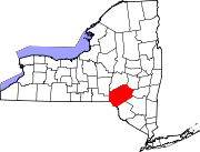
- Colchester, New York
-
Colchester, New York — Town — Location within the state of New York Coordinates: 42°1′45″N 74°57′56″W / 42.02917°N 74.96556°W Country United States State New York County Delaware Government - Type Town Council - Town Supervisor Robert Homovich (R) - Town Council Members' ListArea - Total 142.2 sq mi (368.3 km2) - Land 137.4 sq mi (356.0 km2) - Water 4.8 sq mi (12.3 km2) Elevation 2,388 ft (728 m) Population (2000) - Total 2,042 - Density 14.9/sq mi (5.7/km2) Time zone Eastern (EST) (UTC-5) - Summer (DST) EDT (UTC-4) ZIP code 13856 Area code(s) 607 FIPS code 36-16793 GNIS feature ID 0978848 Colchester is a town in Delaware County, New York, USA. The population was 2,042 at the 2000 census.
The Town of Colchester is in the southwest part of the county.
Contents
History
Colchester was formed from part of the Town of Middletown in 1792.
Geography
The south town line is the border of Sullivan County, New York.
According to the United States Census Bureau, the town has a total area of 142.2 square miles (368 km2), of which, 137.4 square miles (356 km2) of it is land and 4.8 square miles (12 km2) of it (3.35%) is water.
Demographics
As of the census[1] of 2000, there were 2,042 people, 837 households, and 547 families residing in the town. The population density was 14.9 people per square mile (5.7/km²). There were 1,587 housing units at an average density of 11.5 per square mile (4.5/km²). The racial makeup of the town was 98.53% White, 0.34% African American, 0.20% Native American, 0.15% Asian, 0.10% from other races, and 0.69% from two or more races. Hispanic or Latino of any race were 0.78% of the population.
There were 837 households out of which 24.3% had children under the age of 18 living with them, 54.2% were married couples living together, 7.3% had a female householder with no husband present, and 34.6% were non-families. 29.6% of all households were made up of individuals and 15.8% had someone living alone who was 65 years of age or older. The average household size was 2.32 and the average family size was 2.86.
In the town the population was spread out with 21.0% under the age of 18, 6.1% from 18 to 24, 23.5% from 25 to 44, 26.5% from 45 to 64, and 22.9% who were 65 years of age or older. The median age was 45 years. For every 100 females there were 93.6 males. For every 100 females age 18 and over, there were 92.9 males.
The median income for a household in the town was $32,147, and the median income for a family was $37,895. Males had a median income of $27,143 versus $20,694 for females. The per capita income for the town was $15,636. About 8.5% of families and 12.7% of the population were below the poverty line, including 22.2% of those under age 18 and 7.8% of those age 65 or over.
Communities and locations in Colchester
- Cook's Falls –
- Corbett –
- Downsville – A hamlet and former village in the town.
- Little Spring Brook- A small hamlet on the eastern most side of the town of Colchester, New York. Located 5 miles (8.0 km) north of Roscoe, New York and 5 miles (8.0 km) south of the Pepacton Reservoir on NYS Route 206. Population is 15 full time residents and 35 seasonal residents. Little Spring Brook is the gateway to more than 1,000 acres (4.0 km2) of NYS Land and Forest Preserve (New York) managed by the New York State Department of Environmental Conservation which is used for seasonal hunting, snowmobiling and hiking.
- Horton –
- Pepacton Reservoir – Part of the New York City Water System.
- Shinhopple –
Notable residents
- William Elbridge Sewell, Governor of Guam was born here.
References
- ^ "American FactFinder". United States Census Bureau. http://factfinder.census.gov. Retrieved 2008-01-31.
External links
Coordinates: 42°09′37″N 75°04′39″W / 42.16028°N 75.0775°W
Municipalities and communities of Delaware County, New York County seat: Delhi Towns Villages Delhi | Deposit‡ | Fleischmanns | Franklin | Hancock | Hobart | Margaretville | Sidney | Stamford | Walton
Hamlets Andes | Arkville | Downsville | Grand Gorge | Islamberg
Footnotes ‡This populated place also has portions in an adjacent county or counties
Categories:- Towns in New York
- Populated places in Delaware County, New York
Wikimedia Foundation. 2010.


