- New York State Route 421
-
NYS Route 421
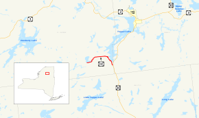
Map of the Tupper Lake area with NY 421 highlighted in redRoute information Maintained by NYSDOT Length: 5.70 mi[3] (9.17 km) Existed: ca. 1931[1][2] – present Major junctions West end: Dead end at Horseshoe Lake in Piercefield East end:  NY 30 in Piercefield
Location Counties: St. Lawrence Highway system Numbered highways in New York
Interstate • U.S. • N.Y. (former) • Reference • County←  NY 420
NY 422  →
→New York State Route 421 (NY 421) is a short state highway located within Adirondack Park in the southeastern corner of St. Lawrence County, New York, United States. It is a narrow, two-lane spur route connecting NY 30 to Horseshoe Lake by way of Tupper Lake. A dead end sign is posted immediately off NY 30, the only route with which it intersects. The entire road is located in the town of Piercefield, although that name is not posted on NY 421. The route offers access to several picnic and snowmobile areas.
The eastern portion of NY 421 was built in the 1920s under the terms of a 1923 law authorizing the construction of a highway leading from modern NY 30 north to Warren Point. NY 421 was assigned to the entirety of the north–south highway ca. 1931. The roadway connecting Horseshoe Lake to Tupper Lake was built ca. 1962 and became part of NY 421 by 1968. NY 421's former routing to Warren Point remained a state highway up through 1999, when a law was passed allowing the New York State Department of Transportation (NYSDOT) to remove it from the state highway system once NYSDOT was able to transfer ownership and maintenance of the highway to another entity.
Contents
Route description
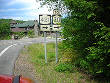 Sign assembly along NY 421 eastbound near the Veterans' Mountain Camp
NY 421 begins at an intersection with NY 30 near the St. Lawrence – Franklin County line in the town of Piercefield, located near the center of Adirondack Park. The highway heads northward as the two-lane Paradise Point Road, offering access to private residences as it crosses over the Bog River and runs along the western edge of Tupper Lake. After 1.6 miles (2.6 km), NY 421 comes to the Veterans' Mountain Camp at Paradise Point. Here, Paradise Point Road continues east to the camp while NY 421 heads north to a cluster of buildings at a junction with Warren Point Road. Here, NY 421 turns to head westward into the wilderness of the park.[4]
It proceeds west for roughly 2 miles (3.2 km) before curving to the southwest as it approaches Horseshoe Lake. It runs along the southern edge of the lake to its western extent, where it turns northward to follow the lake's western shore to the isolated hamlet of Horseshoe. The route proceeds northward through Horseshoe to what was once a railroad crossing, where NY 421 comes to an end. The roadway also ends here, as only dirt trails exist beyond this point.[4]
History
In 1923, the New York State Legislature passed a law authorizing the construction of a highway connecting Route 24 (an unsigned legislative route that is now part of NY 30) to the new Veterans' Mountain Camp, an American Legion camp on Tupper Lake. The work was funded through appropriations defined in the law.[5] The highway was completed by 1929[6] and extended from modern NY 30 north to a dead end at Warren Point.[7] In the 1930 renumbering of state highways in New York, hundreds of state-maintained highways that did not yet have a designation were assigned one.[8] The Veterans' Mountain Camp highway was designated as NY 421 by the following year.[1][2]
A highway leading westward from NY 421 southwest of Warren Point to Horseshoe Lake was completed ca. 1962.[9][10] It became part of an extended NY 421 by 1968. The former routing of NY 421 north to Warren Point, legislatively designated as State Highway 9106B, was initially considered a spur of NY 421;[11][12] it was later redesignated as NY 971D, an unsigned reference route.[13] After the Veterans' Mountain Camp was closed in the 1960s, the property was sold off to private owners, turning NY 971D into little more than a private drive. Thus, the road saw little use, handling less than 10 vehicles per day on average. As a result, the New York State Department of Transportation (NYSDOT) no longer considered the highway worthy of inclusion in the state highway system and began to take steps to remove the highway from the system.[7]
On February 22, 1999, NYSDOT sent a memorandum to the New York State Senate that laid out the groundwork for a bill which, if passed, would allow NYSDOT to remove NY 971D from the state highway system once it was able to transfer ownership and maintenance of the highway to another entity.[7] The memo was officially made into a bill on March 29 when State Senator Raymond Meier introduced bill S4159 in the New York State Senate. An identical bill (A8056) was introduced in the New York State Assembly on April 26 by the Assembly Rules Committee at the request of Assemblyman David Gantt. S4159 passed the Senate on April 28 and replaced A8056 in the Assembly on June 17, on which day it also passed the Assembly. The bill was signed into law by Governor George Pataki on July 27, 1999.[14] The former routing of NY 971D is now officially a private drive.[15]
Major intersections
The entire route is in Piercefield, St. Lawrence County.
Mile[3] Destinations Notes 0.00 Dead end at Horseshoe Lake 5.70 NY 301.000 mi = 1.609 km; 1.000 km = 0.621 mi References
- ^ a b Standard Oil Company of New York (1930). Road Map of New York (Map). Cartography by General Drafting.
- ^ a b Standard Oil Company (1931). New York (Map). Cartography by General Drafting.
- ^ a b "2008 Traffic Data Report for New York State" (PDF). New York State Department of Transportation. June 16, 2009. p. 312. https://www.nysdot.gov/divisions/engineering/technical-services/hds-respository/NYSDOT_Traffic_Data_Report_2008.pdf. Retrieved December 8, 2009.
- ^ a b Google, Inc. Google Maps – overview map of NY 421 (Map). Cartography by Google, Inc. http://maps.google.com/maps?sourceid=navclient&ie=UTF-8&rlz=1T4ADBF_enUS232US232&q=from:+Paradise+Point+Rd+%4044.120120,+-74.539520+to:+RT-421+%4044.124800,+-74.626497&um=1&sa=N&tab=wl. Retrieved April 10, 2008.
- ^ New York State Legislature (1923). Laws of the State of New York. 1–2. p. 177.
- ^ Standard Oil Company of New York (1929). New York in Soconyland (Map). Cartography by General Drafting.
- ^ a b c New York State Legislature; et al. (July 28, 1999). "Bill S4159 (1999) and related documents" (PDF). http://image.iarchives.nysed.gov/images/images/115656.pdf. Retrieved December 17, 2009.
- ^ Dickinson, Leon A. (January 12, 1930). "New Signs for State Highways". The New York Times: p. 136.
- ^ Sunoco (1961). New York and Metropolitan New York (Map). Cartography by H.M. Gousha Company (1961–62 ed.).
- ^ Esso (1962). New York with Sight-Seeing Guide (Map). Cartography by General Drafting.
- ^ New York State Department of Transportation (1968). Piercefield Digital Raster Quadrangle (Map). 1:24,000. http://www.nysgis.state.ny.us/gisdata/quads/drg24/dotpreview/index.cfm?code=g42. Retrieved December 17, 2009.
- ^ New York State Department of Transportation (1969). Long Tom Mountain Digital Raster Quadrangle (Map). 1:24,000. http://www.nysgis.state.ny.us/gisdata/quads/drg24/dotpreview/index.cfm?code=g41. Retrieved December 17, 2009.
- ^ Perry, N.W.. "Region 7 Reference Routes". Empire State Roads. http://www.empirestateroads.com/sr/refroute7.html. Retrieved December 17, 2009.
- ^ New York State Legislature. "Bill Status Search by Bill Number". http://public.leginfo.state.ny.us/menugetf.cgi. Retrieved December 17, 2009.
- ^ "St. Lawrence County Inventory Listing" (CSV). New York State Department of Transportation. October 1, 2009. https://www.nysdot.gov/divisions/engineering/technical-services/hds-repository2/INV_2009-10-01_StLawrence.csv. Retrieved December 16, 2009.
External links
Categories:- State highways in New York
- Transportation in St. Lawrence County, New York


Wikimedia Foundation. 2010.