- New York State Route 67
-
NYS Route 67
Route information Maintained by NYSDOT, the town of Ephratah, the cities of Amsterdam, Johnstown and Mechanicville, and the village of Ballston Spa Length: 86.55 mi[2] (139.29 km) Existed: 1930[1] – present Major junctions West end:  NY 5 in St. Johnsville
 NY 30A in Johnstown
 NY 5 / NY 30 in Amsterdam
 I-87 in Malta

 US 4 / NY 32 in Mechanicville
East end:  VT 67 at Hoosick
Location Counties: Montgomery, Fulton, Saratoga, Rensselaer, Washington Highway system Numbered highways in New York
Interstate • U.S. • N.Y. (former) • Reference • County←  NY 66
NY 66NY 68  →
→New York State Route 67 (NY 67) is an east–west state highway in eastern New York in the United States. The western terminus of the route is at an intersection with NY 5 in the town of St. Johnsville. Its eastern terminus is at the Vermont state line in Hoosick, where it continues eastward as Vermont Route 67.
Contents
Route description
Montgomery and Fulton Counties
NY 67 begins at an intersection with NY 5 east of the village of St. Johnsville in the town of the same name. It heads eastward across northern Montgomery County as New Turnpike Road to the Fulton County line, where maintenance of NY 67 shifts from the New York State Department of Transportation (NYSDOT) to the town of Ephratah. Thus, the 0.34-mile (0.55 km) segment of New Turnpike Road between the county line and NY 10 has no reference markers. This segment of the route also lacks any shoulders. At NY 10, maintenance of NY 67 returns to NYSDOT as it turns north to overlap NY 10 into the hamlet of Ephratah.[3]
In Ephratah, NY 67 splits from NY 10 and heads east as a narrow and winding highway. It continues into the town of Johnstown, where it meets the eastern terminus of the aforementioned New Turnpike Road (an unimproved town road) at Eppie Corners and winds through hilly terrain through the hamlet of Keck's Center. It intersects the north end of NY 334 before passing into the city of Johnstown. In the western part of the city, NY 67 follows West Main Street for several blocks to William Street, where it is joined by NY 29. After crossing downtown, the overlap with NY 29 ends with NY 29 continuing straight (east) on East Main Street and NY 67 veering southeast onto East State Street. The route exits the city just southeast of a junction with NY 30A. NY 67 proceeds onward, passing the Fulton County Airport, Hamilton-Fulton-Montgomery BOCES, and Fulton-Montgomery Community College before reentering Montgomery County.
Second pass through Montgomery County
Once again in Montgomery County, NY 67 follows a winding, narrow path. One steep curve was eliminated in the early 2000s northwest of Fort Johnson. In Fort Johnson, NY 67 joins NY 5 toward Amsterdam.
In Amsterdam, NY 67 enters with NY 5 as West Main Street. After passing an unusual flashing traffic light at Guy Park Manor, a four-lane highway begins parallel to Main Street. Historically, NY 67 and NY 5 followed Main Street through the city. With the 1977 creation of the Amsterdam Mall, NY 67 and NY 5, together with NY 30, were re-routed onto splits comprising the Amsterdam Arterial.[citation needed] After a left exit for NY 30 southbound and a link to the Thruway, NY 67 follows underneath NY 30 southbound, then takes a left exit next to the mall. NY 67 then follows NY 30 North, crossing NY 5 westbound, then splitting off toward Ballston Spa, passing through the hamlet of Manny Corners, south of the village of Hagaman.
Saratoga County
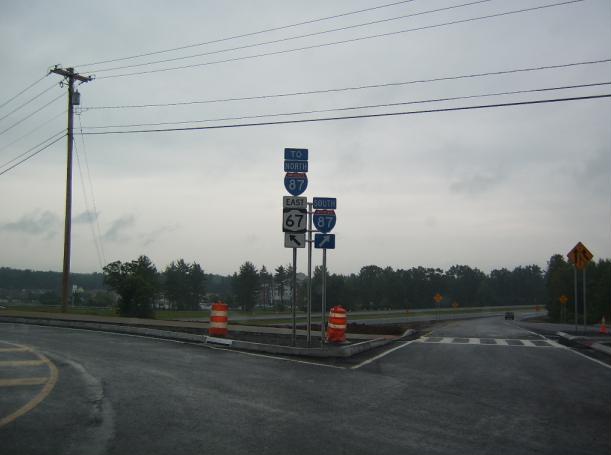
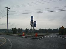 NY 67 at I-87
NY 67 enjoys a wider route, enabling faster driving and more gentle curves, passing south of the village of Galway. In Ballston Spa, NY 67 meets NY 50, turning south and overlapping for about a mile. NY 67 then splits off to the east, heading toward the Adirondack Northway at Malta.
In the Malta Area, NY 67 enters as Dunning Street. Immediately before I-87, there is a roundabout at State Farm Road. A second roundabout shortly thereafter handles the southbound ramp traffic of I-87 exit 12, with a third roundabout handing northbound on the other side. A fourth roundabout handles an intersection with Malta Commons and Kelch Drive, and a fifth handles the intersection with US 9, beginning the overlap with US 9.
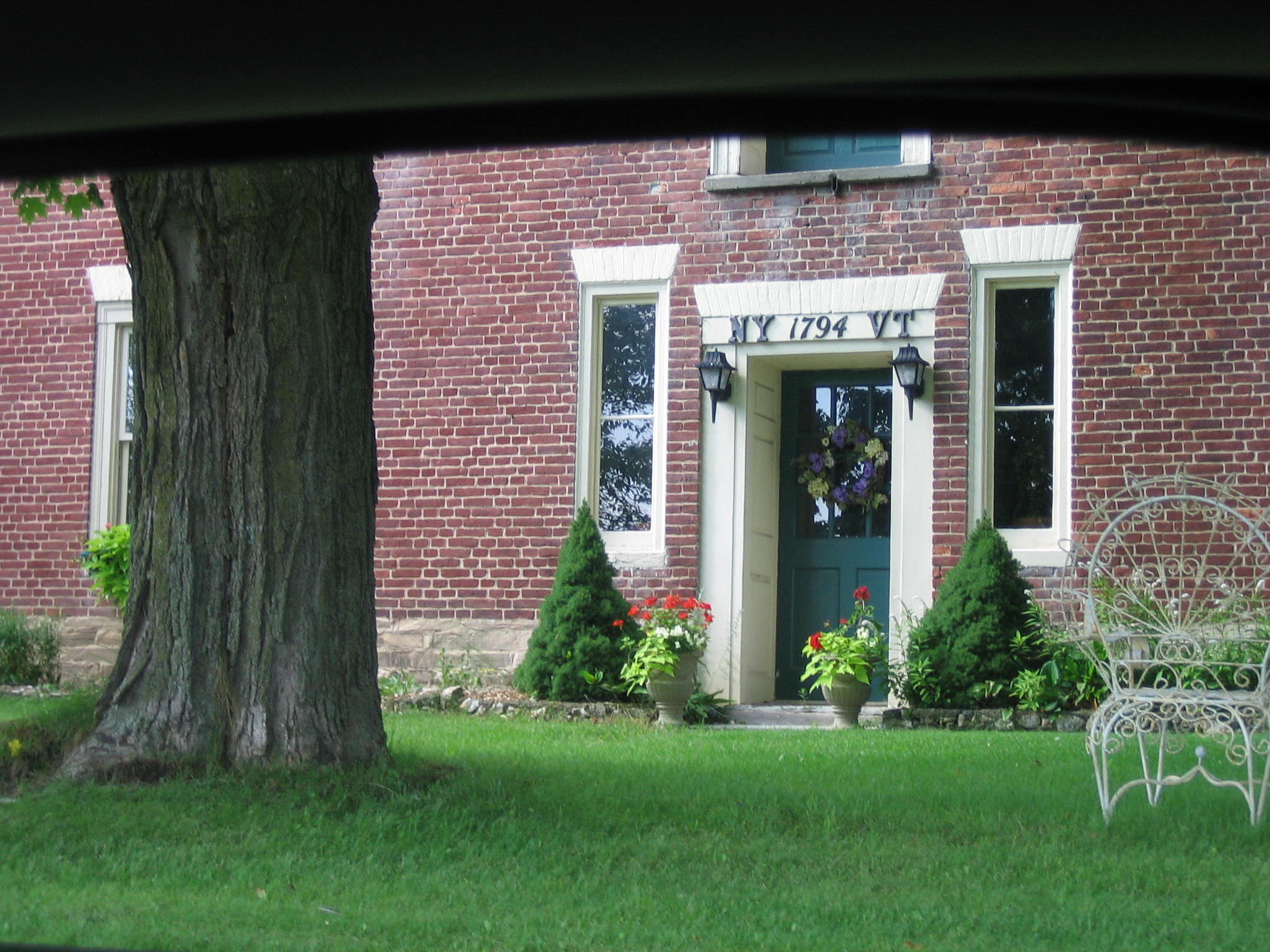
 A house straddling the New York-Vermont state line located on NY/VT 67.
After the final roundabout, NY 67 turns south, concurrent with US 9 for 1.5 miles (2.4 km), just north of the village of Round Lake. Here, the route heads eastward, taking a winding path toward Mechanicville and the Hudson River. After entering the city, NY 67 becomes concurrent with US 4 and NY 32 for less than 0.1 miles (0.2 km), then heads east toward Schaghticoke, crossing the Hudson on the Mechanicville Bridge.
Rensselaer and Washington Counties
Old Schaghticoke Road carries NY 67 eastward and uphill, meeting NY 40 as Reservoir Road. Turning left and overlapping, the routes enter Schaghticoke upon crossing the Hoosic River. Passing through the village, NY 67 splits right at the Schaghticoke Fairgrounds, where CR 125, an old routing of NY 67, enters from the left. NY 67 turns to cross the Hoosic River again in Valley Falls, running south of the river through Buskirk and crossing again in Eagle Bridge to briefly enter Washington County.
NY 67 meets NY 22 in White Creek after 0.9 miles (1.4 km). Turning right, running concurrent for 0.6 miles (1.0 km), the paired routes re-enter Rensselaer County. Once back in Rensselaer County, the routes split at Hoosick Junction. Passing through farmland, NY 67 ends at the Vermont state line, continuing as Vermont Route 67.
History
The portion of modern NY 67 between what is now NY 147 south of Galway and the southern end of the overlap with NY 50 south of Ballston Spa was originally designated as part of two legislative routes by the New York State Legislature in 1908. From Galway to Ballston Spa, what is now NY 67 was part of Route 37. The modern overlap with NY 50 was part of Route 25.[4] In 1912, Route 37 was realigned between Kimball Corners and Saratoga Springs to use modern NY 29. Its former routing between Kimball Corners and Ballston Spa via Galway was redesignated as Route 37-a. Also added in 1912 was Route 37-b, a spur route that ran from Route 25 south of Ballston Spa east to what is now U.S. Route 9 in Malta via current NY 67.[5][6] The Route 37-a and Route 37-b designations were eliminated on March 1, 1921.[7]
When the first set of posted routes in New York were assigned in 1924, the section of modern NY 67 between Round Lake and Mechanicville was designated as part of NY 6.[8][9] Most of NY 6, including the section from Round Lake to Malta, was renumbered to US 9 in 1927.[10] In the 1930 renumbering of state highways in New York, US 9 was realigned onto its modern alignment between Albany and Round Lake. Its former routing from Round Lake to Malta became part of the new NY 67,[1] which extended west to NY 10 in Ephratah and east to the Vermont state line via Johnstown, Amsterdam, Ballston Spa, Stillwater, and Hoosick. From Galway to Malta, NY 67 utilized the former alignments of legislative Routes 25, 37-a and 37-b. Between Mechanicville and Schaghticoke, NY 67 initially ran concurrent with US 4 and NY 32 to Stillwater, where it turned east and followed what is now Rensselaer County Route 125 across the Hudson River to NY 40 north of Schaghticoke.[11]
On April 1, 1980, ownership and maintenance of NY 67 between the access road to lock 4 of the Champlain Canal and NY 40 was transferred from the state of New York to Rensselaer County as part of a highway maintenance swap between the two levels of government. One highway transferred from the county to the state at this time was Old Schaghticoke Road, which extended from the county line at Mechanicville east to NY 40 just southwest of Schaghticoke.[12] NY 67 was realigned to follow the new state highway between Mechanicville and Schaghticoke[13][14] while the county-maintained portion of its former alignment became County Route 125. The short piece of NY 67's former routing between US 4 and NY 32 in Stillwater and the access road to Champlain Canal lock 4 remained state-maintained[15][16] and became NY 915C, an unsigned reference route.[17]
A second maintenance swap, this time between the state and Montgomery County, occurred on April 1, 1981. As part of the swap, ownership and maintenance of New Turnpike Road[12] (County Route 52[18][19]) between NY 5 outside of St. Johnsville and the Fulton County line was transferred from Montgomery County to the state of New York.[12] The new state highway became a westward extension of NY 67, which overlapped a section of NY 10 between Ephratah and NY 10's junction with New Turnpike Road.[13][14] The 0.34-mile (0.55 km) section of New Turnpike Road between the Fulton County line and NY 10 was never transferred to the state and is still maintained by the town of Ephratah.[3]
Major intersections
County Location Mile[2] Destinations Notes Montgomery Town of St. Johnsville 0.00 NY 5Fulton Ephratah 6.11  NY 10 south
Southern terminus of NY 10 / NY 67 overlap 7.74 NY 10 northNorthern terminus of NY 10 / NY 67 overlap Town of Johnstown 14.98  NY 334
Northern terminus of NY 334 City of Johnstown 16.66  NY 29 west
Western terminus of NY 29 / NY 67 overlap 16.97 NY 29 eastEastern terminus of NY 29 / NY 67 overlap 17.54 NY 30AMontgomery Town of Amsterdam 23.80 Antlers Road (CR 3) / McDonald Drive (CR 38) Only appearance of pentagonal county route signs in Montgomery County Fort Johnson 24.90 NY 5 westWestern terminus of NY 5 / NY 67 overlap City of Amsterdam 27.87 NY 5 eastEastern terminus of NY 5 / NY 67 overlap 27.94 NY 30 southSouthern terminus of NY 30 / NY 67 overlap 28.04 NY 528.15 NY 30 northNorthern terminus of NY 30 / NY 67 overlap Saratoga Charlton 37.74  NY 147
Ballston Spa 47.48  NY 50 north
Northern terminus of NY 50 / NY 67 overlap Ballston 48.37 NY 50 southSouthern terminus of NY 50 / NY 67 overlap Malta 51.70 I-87Exit 12 (I-87); two roundabouts service this interchange 52.15  US 9 north
Northern terminus of US 9 / NY 67 overlap; roundabout Round Lake – Malta line 53.73 US 9 southSouthern terminus of US 9 / NY 67 overlap; roundabout Mechanicville 60.03 US 4 south / NY 32 southWestern terminus of US 4 / NY 32 / NY 67 overlap 60.13 US 4 north / NY 32 northEastern terminus of US 4 / NY 32 / NY 67 overlap Rensselaer Town of Schaghticoke 66.13  NY 40 south
Western terminus of NY 40 / NY 67 overlap Village of Schaghticoke 67.68 NY 40 northEastern terminus of NY 40 / NY 67 overlap Washington White Creek 80.00  NY 22 north
Western terminus of NY 22 / NY 67 overlap Rensselaer Hoosick 82.49 NY 22 southEastern terminus of NY 22 / NY 67 overlap 86.55 VT 67Continuation into Vermont 1.000 mi = 1.609 km; 1.000 km = 0.621 mi References
- ^ a b Dickinson, Leon A. (January 12, 1930). "New Signs for State Highways". The New York Times: p. 136.
- ^ a b "2008 Traffic Volume Report for New York State" (PDF). New York State Department of Transportation. June 16, 2009. pp. 126–128. https://www.nysdot.gov/divisions/engineering/technical-services/hds-respository/NYSDOT%20TVR%202008%20by%20Route.pdf. Retrieved January 30, 2010.
- ^ a b "Fulton County Inventory Listing" (CSV). New York State Department of Transportation. March 2, 2010. https://www.nysdot.gov/divisions/engineering/technical-services/hds-repository2/INV_2010-03-02_fulton.csv. Retrieved May 12, 2010.
- ^ State of New York Department of Highways (1909). The Highway Law. Albany, New York: J. B. Lyon Company. pp. 62, 65. http://books.google.com/books?id=jZ0AAAAAMAAJ&pg=PA62. Retrieved May 12, 2010.
- ^ New York State Legislature (1918). "Tables of Laws and Codes Amended or Repealed". Laws of the State of New York passed at the One Hundred and Forty-First Session of the Legislature. Albany, New York: J. B. Lyon Company. pp. 72–73. http://books.google.com/books?id=ffqwAAAAIAAJ&pg=RA1-PA72. Retrieved May 12, 2010.
- ^ New York State Department of Highways (1920). Report of the State Commissioner of Highways. Albany, New York: J. B. Lyon Company. pp. 551–552. http://books.google.com/books?id=Sj4CAAAAYAAJ&pg=PA551. Retrieved May 12, 2010.
- ^ New York State Legislature (1921). "Tables of Laws and Codes Amended or Repealed". Laws of the State of New York passed at the One Hundred and Forty-Fourth Session of the Legislature. Albany, New York: J. B. Lyon Company. p. 42. http://books.google.com/books?id=6pE4AAAAIAAJ&pg=PA42. Retrieved May 12, 2010.
- ^ "New York's Main Highways Designated by Numbers". The New York Times: p. XX9. December 21, 1924.
- ^ Rand McNally and Company (1926). Rand McNally Auto Road Atlas (eastern New York) (Map). http://www.broermapsonline.org/members/NorthAmerica/UnitedStates/Midatlantic/NewYork/unitedstates1926ra_009.html. Retrieved May 12, 2010.
- ^ Automobile Blue Book. 1 (1927 ed.). Chicago: Automobile Blue Book, Inc. 1927. This edition shows U.S. Routes as they were first officially signed in 1927.
- ^ Standard Oil Company of New York (1930). Road Map of New York (Map). Cartography by General Drafting.
- ^ a b c New York State Legislature. "New York State Highway Law § 341". http://public.leginfo.state.ny.us/LAWSSEAF.cgi?QUERYTYPE=LAWS+&QUERYDATA=$$HAY341$$@TXHAY0341+&LIST=LAW+&TARGET=VIEW. Retrieved May 12, 2010.
- ^ a b State of New York (1981). I Love New York Tourism Map (Map). Cartography by Rand McNally and Company.
- ^ a b Rand McNally and Company (1985). New York (Map). ISBN 0-528-91040-X.
- ^ New York State Department of Transportation (1992). Mechanicville Digital Raster Quadrangle (Map). 1:24,000. http://www.nysgis.state.ny.us/gisdata/quads/drg24/dotpreview/index.cfm?code=q49. Retrieved May 12, 2010.
- ^ New York State Department of Transportation (1992). Schaghticoke Digital Raster Quadrangle (Map). 1:24,000. http://www.nysgis.state.ny.us/gisdata/quads/drg24/dotpreview/index.cfm?code=q50. Retrieved May 12, 2010.
- ^ New York State Department of Transportation (January 2009) (PDF). Official Description of Highway Touring Routes, Bicycling Touring Routes, Scenic Byways, & Commemorative/Memorial Designations in New York State. https://www.nysdot.gov/divisions/operating/oom/transportation-systems/repository/2009%20tour-bk.pdf. Retrieved May 12, 2010.
- ^ New York State Department of Transportation (1977). Fort Plain Digital Raster Quadrangle (Map). 1:24,000. http://www.nysgis.state.ny.us/gisdata/quads/drg24/dotpreview/index.cfm?code=q41. Retrieved May 12, 2010.
- ^ New York State Department of Transportation (1977). Canajoharie Digital Raster Quadrangle (Map). 1:24,000. http://www.nysgis.state.ny.us/gisdata/quads/drg24/dotpreview/index.cfm?code=q42. Retrieved May 12, 2010.
External links
Categories:- State highways in New York
- Transportation in Rensselaer County, New York
- Transportation in Montgomery County, New York
- Transportation in Fulton County, New York
- Transportation in Saratoga County, New York
- Transportation in Washington County, New York

Wikimedia Foundation. 2010.