- New York State Route 68
-
NYS Route 68
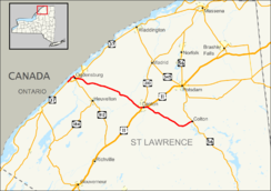
Map of the North Country with NY 68 highlighted in redRoute information Maintained by NYSDOT and the city of Ogdensburg Length: 33.43 mi[3] (53.80 km) Existed: mid-1920s[1][2] – present Major junctions West end:  NY 37 near Ogdensburg
 US 11 in Canton
East end:  NY 56 in Colton
Location Counties: St. Lawrence Highway system Numbered highways in New York
Interstate • U.S. • N.Y. (former) • Reference • County←  NY 67
NY 67NY 69  →
→New York State Route 68 (NY 68) is an east–west state highway located entirely within St. Lawrence County in the North Country of New York in the United States. The western terminus is at an intersection with NY 37 in Oswegatchie, just west of the Ogdensburg city limits. The eastern terminus is at a junction with NY 56 in the community of Colton within the town of Colton. Along the way, NY 68 passes through the village of Canton, where it overlaps with U.S. Route 11 (US 11) through the village.
NY 68 was assigned in the mid-1920s, but only from Canton to Ogdensburg. The route was extended to Colton in 1930, then truncated slightly to end at the NY 37 bypass in the 1970s. NY 68 was re-extended to its current length in 1982 as part of a highway maintenance swap between New York State and St. Lawrence County.
Contents
Route description
The vast majority of NY 68 is maintained by New York State Department of Transportation (NYSDOT). The only section not maintained by the state lies within the city of Ogdensburg, where the route is locally maintained from the junction of State and Canton Streets to the southeastern city line.[4]
Ogdensburg to Canton
Route 68 begins at an intersection with NY 37 (the Seaway Trail) in Ogdensburg. The route heads to the northeast, along the outskirts of downtown Ogdensburg. Along the way, it passes residential homes and several commercial businesses, parallelling the MacDonald-Cartier Freeway (Highway 401) to the north in Ontario and NY 37 to the south. Route 68 crosses a branch of the St. Lawrence River in downtown Ogdensburg, passing Crescent Park soon after. Route 68 heads to the south, intersecting with NY 37 once again along with NY 812 near the Seaway Shopping Center.[5]
After Routes 37 and 812, the road begins to leave Ogdensburg, and the lands around Route 68 become less developed. Route 68 passes the Ogdensburg International Airport after the intersection with County Route 28A. The highway crosses through Oswegatchie uneventfully, entering the hamlet of Flackville. Much of the region between Ogdensburg and Canton is mostly fields, and Route 68 heads through sparsely populated areas until it reaches Canton. The highway parallels a creek before entering the village of Canton.[5]
Canton to Colton
In downtown Canton, Route 68 intersects with US 11 before passing Rushton Falls. Routes 11 and 68 become concurrent through downtown Canton, passing St. Lawrence University and its golf course. At the intersection with NY 310, Routes 11 and 68 split, with 68 heading to the southeast. The urbanization of Route 68 quickly dissipates again, going down hills for some distance. When the road enters the hamlet of Langdons Corners, it passes to the north of Watermann Hill. Several miles later, Route 68 enters Colton and terminates at an intersection with NY 56.[5]
History
When NY 68 was assigned in the mid-1920s, it extended only from US 11 in Canton to the intersection of State and Ford Streets (then-NY 3 and later NY 37) in Ogdensburg.[1][2] In the 1930 renumbering of state highways in New York, NY 68 was extended eastward through Canton to Colton, where it ended at NY 56.[6] In the late 1950s, NY 37 was rerouted to bypass Ogdensburg to the south on a new alignment;[7][8] however, NY 68 continued to extend past the arterial to Ford Street as late as 1969.[9] By the following year, NY 68 was truncated to the intersection of Canton and State Streets, eliminating an overlap with NY 87.[10] NY 68 was truncated again in the mid-1970s to end at its junction with NY 37 southeast of the city center.[11][12]
On September 1, 1982, ownership and maintenance of the portion of NY 68 between the hamlet of Pierrepont and NY 58 in Colton was transferred from St. Lawrence County to the state of New York as part of a highway maintenance swap between the two levels of government. Also exchanged in the swap was the portion of former NY 37 between the western end of the Ogdensburg bypass and the Ogdensburg city line, which had been county maintained prior to this point.[13] Following the swap, NY 68 was re-extended into Ogdensburg, following its former alignment as well as that of NY 37 north and west to its current terminus west of Ogdensburg.[14]
Major intersections
The entire route is in St. Lawrence County.
Location Mile[3] Destinations Notes Ogdensburg 0.00 NY 372.95  NY 37 / NY 812
Town of Canton 15.02  CR 14
CR 14Former eastern terminus of NY 186 Village of Canton 19.93 US 11 southWestern terminus of US 11 / NY 68 overlap Town of Canton 21.32  US 11 north / NY 310
Eastern terminus of US 11 / NY 68 overlap; southern terminus of NY 310 Colton 33.43 NY 56Hamlet of Colton 1.000 mi = 1.609 km; 1.000 km = 0.621 mi References
- ^ a b "New York's Main Highways Designated by Numbers". The New York Times: p. XX9. December 21, 1924.
- ^ a b Rand McNally and Company (1926). Rand McNally Auto Road Atlas (eastern New York) (Map). http://www.broermapsonline.org/members/NorthAmerica/UnitedStates/Midatlantic/NewYork/unitedstates1926ra_009.html. Retrieved May 13, 2010.
- ^ a b "2008 Traffic Volume Report for New York State" (PDF). New York State Department of Transportation. June 16, 2009. p. 128. https://www.nysdot.gov/divisions/engineering/technical-services/hds-respository/NYSDOT%20TVR%202008%20by%20Route.pdf. Retrieved January 30, 2010.
- ^ "St. Lawrence County Inventory Listing" (CSV). New York State Department of Transportation. March 2, 2010. https://www.nysdot.gov/divisions/engineering/technical-services/hds-repository2/INV_2010-03-02_st_lawrence.csv. Retrieved December 20, 2010.
- ^ a b c Google, Inc. Google Maps – overview map of NY 68 (Map). Cartography by Google, Inc. http://maps.google.com/maps?sourceid=navclient&ie=UTF-8&rlz=1T4ADBF_enUS232US232&q=from:+RT-68+N+%4044.679239,+-75.519198+to:+Downtown+Arterial+Hwy/RT-68+%4044.692564,+-75.504183+to:Colton-Pierrepont+Rd/RT-68+%4044.550000,+-74.936500&um=1&sa=N&tab=wl. Retrieved March 26, 2008.
- ^ Dickinson, Leon A. (January 12, 1930). "New Signs for State Highways". The New York Times: p. 136.
- ^ Esso (1958). New York with Special Maps of Putnam–Rockland–Westchester Counties and Finger Lakes Region (Map). Cartography by General Drafting (1958 ed.).
- ^ Gulf Oil Company (1960). New York and New Jersey Tourgide Map (Map). Cartography by Rand McNally and Company.
- ^ New York State Department of Transportation (1969). Ogdensburg Digital Raster Quadrangle (Map). 1:24,000. http://www.nysgis.state.ny.us/gisdata/quads/drg24/dotpreview/index.cfm?code=c35. Retrieved May 13, 2010.
- ^ State of New York Department of Transportation (January 1, 1970) (PDF). Official Description of Touring Routes in New York State. http://www.greaternyroads.info/pdfs/state70.pdf. Retrieved January 3, 2010.
- ^ Shell Oil Company (1973). New York (Map). Cartography by H.M. Gousha Company (1973 ed.).
- ^ Exxon (1977). New York (Map). Cartography by General Drafting (1977–78 ed.).
- ^ New York State Legislature. "New York State Highway Law § 341". http://public.leginfo.state.ny.us/LAWSSEAF.cgi?QUERYTYPE=LAWS+&QUERYDATA=$$HAY341$$@TXHAY0341+&LIST=LAW+&TARGET=VIEW. Retrieved May 13, 2010.
- ^ I Love New York (2009). New York State Map (Map). Cartography by Map Works.
External links
Categories:- State highways in New York
- Transportation in St. Lawrence County, New York


Wikimedia Foundation. 2010.