- New York State Route 812
-
NYS Route 812
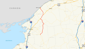
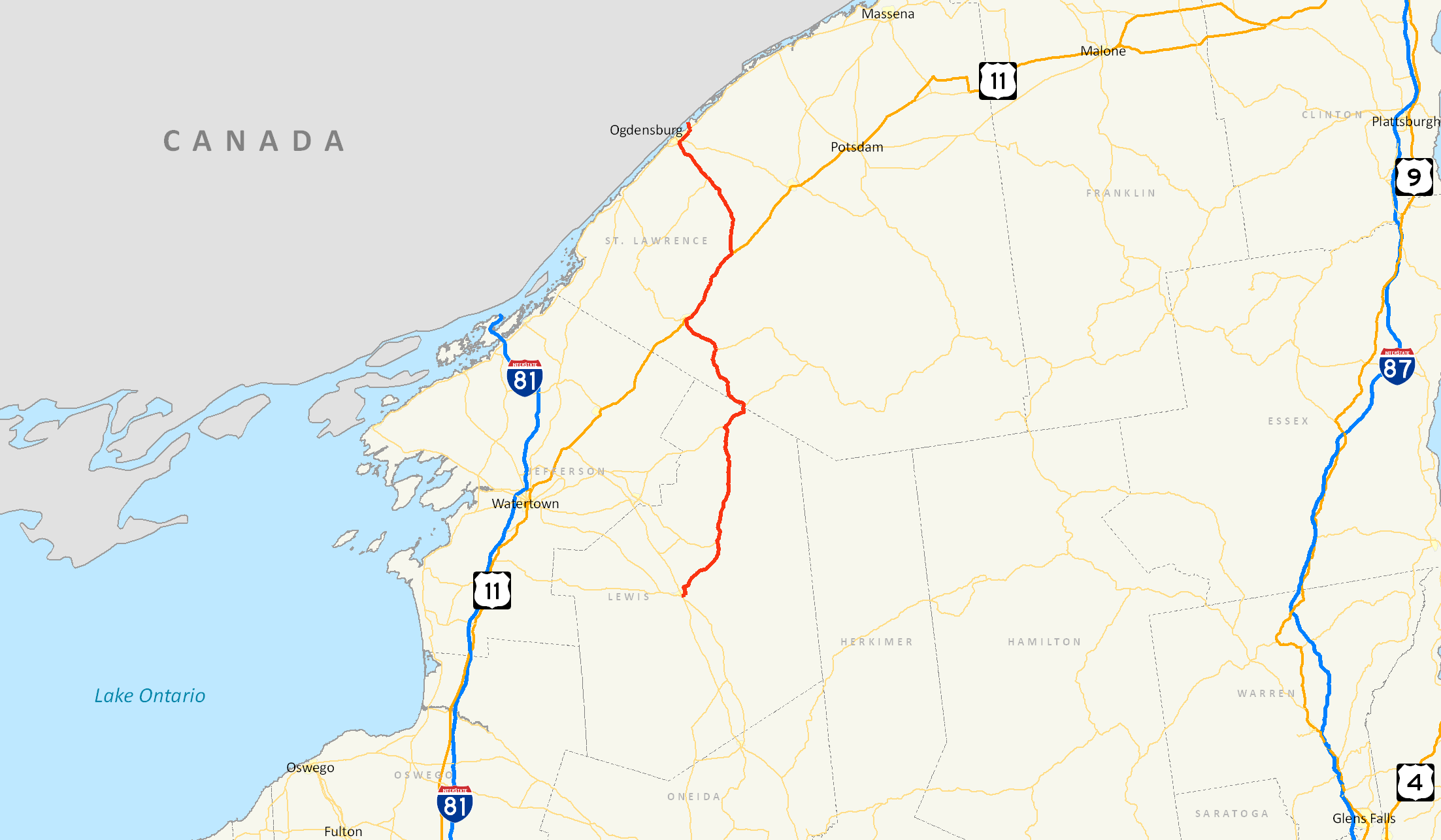
Map of northern New York with NY 812 highlighted in redRoute information Maintained by NYSDOT and the Ogdensburg Bridge and Port Authority Length: 80.91 mi[3] (130.21 km) Existed: late 1970s[1][2] – present Major junctions South end: 
 NY 12 / NY 26 in Lowville
 NY 3 in Harrisville

 US 11 / NY 58 in Gouverneur
 NY 37 in Ogdensburg
North end:  Highway 16 at Ogdensburg
Location Counties: Lewis, St. Lawrence Highway system Numbered highways in New York
Interstate • U.S. • N.Y. (former) • Reference • County←  I-790
I-790NY 825  →
→New York State Route 812 (NY 812) is a state highway in the North Country of New York in the United States. The southern terminus of the route is at an intersection with NY 12 and NY 26 in the Lewis County village of Lowville. Its northern terminus is at the Canada – United States border in Ogdensburg, where it crosses the Ogdensburg–Prescott International Bridge and connects to Highway 16 in Ontario. While most of NY 812 passes through rural areas of the North Country, the route also serves several villages and small communities.
The origins of NY 812 date back to the 1930 renumbering of state highways in New York, when the portion of modern NY 812 from Lowville to Croghan became part of NY 26A and the segment of modern NY 812 between De Kalb and Ogdensburg was designated as the northernmost portion of New York State Route 87. NY 87 originally extended as far south as Harrisville; however, it was truncated north to Edwards in the 1940s and farther north to De Kalb in the 1970s.
In the late 1970s, all of NY 87 and the Lowville–Croghan leg of NY 26A were replaced with NY 812, a new route that began in Lowville and passed through Croghan, Harrisville, Gouverneur, and De Kalb before ending near Ogdensburg. At the time, two sections of the route—from the Croghan village line to a point west of Harrisville and from Harrisville to Fowler—were maintained by the counties that they passed through, and a piece between NY 126 and the Croghan village line was maintained by the village itself. The state of New York assumed maintenance of the Croghan–Harrisville segment in 1980 and took over the Harrisville–Fowler section in 1982.
Contents
Route description
Lewis County
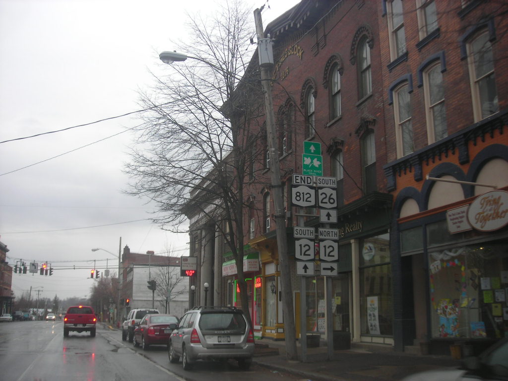
NY 812 begins at an intersection with NY 12 and NY 26 in the center of Lowville. NY 26, concurrent with NY 12 south of this point, leaves NY 12 and follows NY 812 for several blocks along North State Street before NY 812 turns northeast onto Bostwick Street. Just before Bostwick ends at East State Street, NY 812 turns off and begins its progression northward through a largely rural area of the North Country. As it exits the village of Lowville (and enters the town of the same name), it begins to parallel the western bank of the Black River. The two entities remain close for roughly 1 mile (1.6 km) before NY 812 crosses over the river and enters New Bremen.[4]
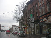 Southern terminus of NY 812 in Lowville
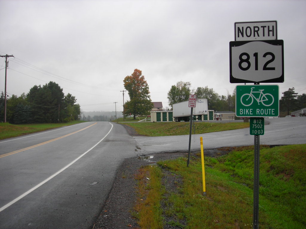
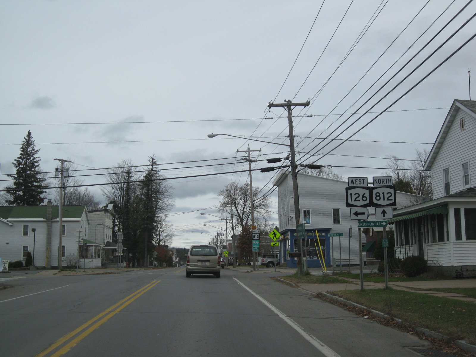
In the hamlet of New Bremen, NY 812 intersects County Route 33 (CR 33), a riverside roadway bypassing both Croghan and Beaver Falls along the east bank of the Black River, southwest of Duflo Airport. NY 812 continues onward, crossing the Black Creek as it enters Croghan, a village situated on the New Bremen – Croghan town line. At the center of the community, NY 812 meets the eastern terminus of NY 126.[4]
Outside of Croghan, NY 812 traverses the Beaver River just north of the village line. The route and the river continue northward along parallel routings for a brief distance before the two separate near the hamlet of High Falls. While the river curves east toward the hamlet, NY 812 presses northward through the rural hamlets of Indian River and Dutton Corners into the town of Diana, where NY 812 starts to parallel the west branch of the Oswegatchie River as both continue north through the town. At Tylers Corners, NY 812 intersects NY 3 and joins the route eastward into Harrisville, where the conjoined routes cross over the Oswegatchie. Northeast of Harrisville in extreme southwestern St. Lawrence County, NY 812 breaks from NY 3 and heads northwest through Pitcairn (crossing over the Oswegatchie once more in the process).[4]
St. Lawrence County
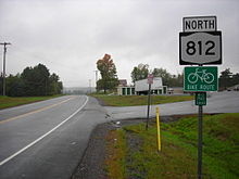 Northbound on NY 812 in Pitcairn, just north of where NY 812 leaves NY 3
From Harrisville, NY 812 travels north through an area of Pitcairn and Fowler. This area contains numerous small lakes and rivers and is predominantly rural in nature. Within Fowler, the route serves the hamlet of Balmat (located on the eastern edge of Sylvia Lake) before intersecting NY 58 in the hamlet of Fowler. Here, NY 812 joins NY 58 northeast along the southern bank of the now-unified Oswegatchie River to the village of Gouverneur, where NY 812 leaves NY 58 but joins U.S. Route 11 (US 11) at the heart of the community.[4]
Outside of the village in the town of the same name, US 11 and NY 812 head northeast, roughly paralleling the Oswegatchie once more into the De Kalb village of Richville. The routes quickly exit the village and separate shortly thereafter south of the hamlet of De Kalb, with the Oswegatchie leaving the path of US 11 and following NY 812. NY 812 heads north, serving De Kalb and crossing over the Oswegatchie south of an intersection with CR 14, a connector leading to Rensselaer Falls that was once NY 186. Here, NY 812 begins to the northwest as it approaches the village of Heuvelton.[4]
Within the village, NY 812, here known as State Street, intersects NY 184 just before traversing the Oswegatchie one final time. The name remains for three blocks before NY 812 departs the village and reemerges into the town of Oswegatchie. Farther north, NY 812 passes by the Ogdensburg International Airport before meeting NY 37 at an interchange just south of the Ogdensburg city limits. NY 812 joins NY 37 here, following the route through the southern reaches of the city. The conjoined routes intersect NY 68 before separating near the northeastern city limits. Past NY 37, NY 812 continues onto the Ogdensburg–Prescott International Bridge over the St. Lawrence River, where it becomes Highway 16 upon crossing the Canada – United States border into Ontario.[4]
History
In the 1930 renumbering of state highways in New York, what is now NY 812 between Lowville and Croghan became the southern leg of NY 26A, an alternate route of NY 26 between Lowville and Carthage. Farther north, the portion of modern NY 812 between De Kalb and Ogdensburg became part of NY 87,[5] a route extending from Harrisville to Ogdensburg via Edwards, Russell and De Kalb.[6] From Harrisville to Fowler, NY 87 followed a parallel alignment to modern NY 812 along Hands Flats, Stone, and Pitcairn Roads, and CR 135. Between Fowler and De Kalb, NY 87 used what is now NY 58, CR 24, and CR 17 before following current NY 812 north to Ogdensburg. The portion of NY 87 between De Kalb Junction and De Kalb was concurrent with US 11.[7] Both US 11 and NY 87 were shifted south onto a new highway ca. 1936, at which time the former routing of US 11 between the new road and De Kalb became part of NY 87.[8][9]
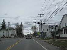 NY 812 north at NY 126 in Croghan. Prior to the 1970s, NY 26A entered this junction on modern NY 812 and left to the west on current NY 126.
NY 87 was gradually truncated northward over time. The first change to the route's southern end came in the early 1940s when it was moved northeastward to the eastern terminus of its former overlap with NY 58 in Edwards.[10][11] It was moved once more, this time to what was the west end of its overlap with US 11 in De Kalb, in the early 1970s.[12][13] NY 87 was eliminated entirely in the late 1970s when it became part of NY 812, a new route extending from Lowville to Ogdensburg via Croghan, Harrisville, Gouverneur, and De Kalb that also supplanted NY 26A south of Croghan.[1][2]
When NY 812 was first assigned, it was locally maintained from NY 126 in Croghan to NY 3 in Diana and from NY 3 in Pitcairn to NY 58 in Fowler. The section of the route between NY 126 and the Croghan village line was maintained by the village of Croghan; however, the rest of the two locally-maintained sections were maintained by Lewis and St. Lawrence Counties. Most of the Lewis County-owned section was co-designated as CR 11; however, the short piece between the Croghan village line and Belfort Road was part of CR 10.[14][15] In St. Lawrence County, NY 812 was overlaid on the existing CR 73 from NY 3 to Stone Road, CR 99 between Stone Road and Balmat, and CR 56 from Balmat to Fowler.[16][17] The state of New York assumed ownership and maintenance of NY 812 between Croghan and Diana on April 1, 1980, as part of a highway maintenance swap between the state and Lewis County that transferred NY 194 to the county. Ownership of NY 812 from Pitcairn to Fowler was transferred to the state on September 1, 1982, as part of a highway maintenance swap between the state and St. Lawrence County.[18]
Major intersections
County Location Mile[3] Destinations Notes Lewis Village of Lowville 0.00 NY 12 / NY 26 southSouthern terminus of NY 26 / NY 812 overlap 0.37 NY 26 northNorthern terminus of NY 26 / NY 812 overlap Village of Croghan 9.90  NY 126
Eastern terminus of NY 126 Diana 26.65 NY 3 westSouthern terminus of NY 3 / NY 812 overlap St. Lawrence Pitcairn 31.09 NY 3 eastNorthern terminus of NY 3 / NY 812 overlap Fowler 41.11 NY 58 southSouthern terminus of NY 58 / NY 812 overlap Village of Gouverneur 47.20 US 11 south / NY 58 northNorthern terminus of NY 58 / NY 812 overlap; southern terminus of US 11 / NY 812 overlap De Kalb 58.63 US 11 northNorthern terminus of US 11 / NY 812 overlap Heuvelton 70.44  NY 184
Eastern terminus of NY 184 Ogdensburg 76.92 NY 37 westWestern terminus of NY 37 / NY 812 overlap 77.26  NY 68
NY 68Ogdensburg–Lisbon line 79.33 NY 37 eastEastern terminus of NY 37 / NY 812 overlap Ogdensburg 80.91 Highway 16Ogdensburg–Prescott International Bridge; continuation into Ontario 1.000 mi = 1.609 km; 1.000 km = 0.621 mi References
- ^ a b Exxon (1977). New York (Map). Cartography by General Drafting (1977–78 ed.).
- ^ a b Exxon (1979). New York (Map). Cartography by General Drafting.
- ^ a b "2008 Traffic Data Report for New York State" (PDF). New York State Department of Transportation. June 16, 2009. p. 325. https://www.nysdot.gov/divisions/engineering/technical-services/hds-respository/NYSDOT_Traffic_Data_Report_2008.pdf. Retrieved November 15, 2009.
- ^ a b c d e f I Love New York (2007). 30th Anniversary New York (Map). Cartography by Map Works.
- ^ Dickinson, Leon A. (January 12, 1930). "New Signs for State Highways". The New York Times: p. 136.
- ^ Automobile Legal Association (ALA) Automobile Green Book, 1930–31 and 1931–32 editions, (Scarborough Motor Guide Co., Boston, 1930 and 1931). The 1930–31 edition shows New York state routes prior to the 1930 renumbering
- ^ Standard Oil Company of New York (1930). Road Map of New York (Map). Cartography by General Drafting.
- ^ Sun Oil Company (1935). Road Map & Historical Guide – New York (Map). Cartography by Rand McNally and Company.
- ^ Standard Oil Company (1936). New York (Map). Cartography by General Drafting.
- ^ Shell Oil Company (1940). Map of New York (Map). Cartography by H.M. Gousha Company.
- ^ Esso (1942). New York with Pictorial Guide (Map). Cartography by General Drafting.
- ^ State of New York Department of Transportation (January 1, 1970) (PDF). Official Description of Touring Routes in New York State. http://www.greaternyroads.info/pdfs/state70.pdf. Retrieved November 15, 2009.
- ^ Shell Oil Company (1973). New York (Map). Cartography by H.M. Gousha Company (1973 ed.).
- ^ New York State Department of Transportation (1969). Croghan Digital Raster Quadrangle (Map). 1:24,000. http://www.nysgis.state.ny.us/gisdata/quads/drg24/dotpreview/index.cfm?code=i35. Retrieved November 15, 2009.
- ^ New York State Department of Transportation (1969). Remington Corners Digital Raster Quadrangle (Map). 1:24,000. http://www.nysgis.state.ny.us/gisdata/quads/drg24/dotpreview/index.cfm?code=h36. Retrieved November 15, 2009.
- ^ New York State Department of Transportation (1968). Harrisville Digital Raster Quadrangle (Map). 1:24,000. http://www.nysgis.state.ny.us/gisdata/quads/drg24/dotpreview/index.cfm?code=g36. Retrieved November 15, 2009.
- ^ New York State Department of Transportation (1969). Gouverneur Digital Raster Quadrangle (Map). 1:24,000. http://www.nysgis.state.ny.us/gisdata/quads/drg24/dotpreview/index.cfm?code=f35. Retrieved November 15, 2009.
- ^ New York State Legislature. "New York State Highway Law § 341". http://public.leginfo.state.ny.us/LAWSSEAF.cgi?QUERYTYPE=LAWS+&QUERYDATA=$$HAY341$$@TXHAY0341+&LIST=LAW+&TARGET=VIEW. Retrieved November 1, 2010.
External links
Categories:- State highways in New York
- Transportation in Lewis County, New York
- Transportation in St. Lawrence County, New York

Wikimedia Foundation. 2010.