- Croghan (village), New York
-
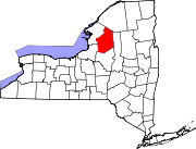
Croghan, New York — Village — Local grocery store and traditional soda fountain in Main Street, Croghan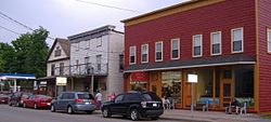 Location within the state of New York
 Croghan, New York
Coordinates: 43°53′31″N 75°23′28″W / 43.89194°N 75.39111°WCoordinates: 43°53′31″N 75°23′28″W / 43.89194°N 75.39111°W Country United States State New York County Lewis Area – Total 0.4 sq mi (1.1 km2) – Land 0.4 sq mi (1.1 km2) – Water 0.0 sq mi (0.0 km2) Elevation 827 ft (252 m) Population (2000) – Total 665 – Density 1,525.7/sq mi (589.1/km2) Time zone Eastern (EST) (UTC-5) – Summer (DST) EDT (UTC-4) ZIP code 13327 Area code(s) 315 FIPS code 36-19070 GNIS feature ID 0947761 Croghan is a village in Lewis County, New York, USA. Its population was 665 at the 2000 census.[1]
The village is situated mainly in the south part of the town of Croghan, with a small part in New Bremen. The town and the village were both named after George Croghan, a soldier in the War of 1812.
The village slogan, which reflects Croghan's proximity to the Adirondack Mountains, is "In the Foothills of the Adirondacks."[2]
Contents
History
The village was once a booming region for the lumber industry. During the late 19th century, one particularly influential member of the local community was the millionaire lumber baron, Theodore B. Basselin, whose estate sat on the corner of Main Street and Bank Street. His mansion remains there to this day.[3] Basselin is now buried in a private family plot along Main Street, next to the village library, which once served as the opera house.
Croghan survived two major fires in the early 1900s, the first which claimed the lives of two small children. The fire started next to where Stumps Tavern now sits along Main and Mechanic and engulfed most of the village, even burning down the massive Catholic Church and divinity school.
The village now takes great pride in its "world famous Croghan Bologna" and was a center of the pure maple syrup industry before a microburst in the mid-1990s which brought extremely high winds, destroying many of the older, larger trees.
Croghan is popular with avid outdoorsmen from around the country who visit the area in the summer for fishing and camping, in the fall for hunting, and in the winter for sledding.
Geography
Croghan is located at 43°53′31″N 75°23′28″W / 43.89194°N 75.39111°W (43.892068, -75.391207), at the junction of New York State Routes 126 and 812.[4]
According to the United States Census Bureau, the village has a total area of 0.4 square miles (1.1 km²). None of the area is covered with water.[1]
The Beaver River flows through the village. Croghan is northeast of the county seat, Lowville.
Adjacent communities
Kirschnerville is to the east of Croghan, New Bremen to its south; Beaver Falls is down the Beaver River to the west, and Belfort up the river to the northeast.
Demographics
As of the census[5] of 2000, there were 665 people, 284 households, and 178 families residing in the village. The population density was 1,525.7 people per square mile (583.5/km²). There were 323 housing units at an average density of 741.1 per square mile (283.4/km²). The racial makeup of the village was 98.65% White, 0.60% Black or African American, 0.15% Native American, 0.45% Asian, and 0.15% from two or more races. Hispanic or Latino of any race were 0.45% of the population.
There were 284 households out of which 28.5% had children under the age of 18 living with them, 49.6% were married couples living together, 9.5% had a female householder with no husband present, and 37.3% were non-families. 33.8% of all households were made up of individuals and 21.5% had someone living alone who was 65 years of age or older. The average household size was 2.34 and the average family size was 3.06.
In the village the population was spread out with 26.3% under the age of 18, 8.4% from 18 to 24, 23.3% from 25 to 44, 19.8% from 45 to 64, and 22.1% who were 65 years of age or older. The median age was 39 years. For every 100 females there were 86.8 males. For every 100 females age 18 and over, there were 83.5 males.
The median income for a household in the village was $26,304, and the median income for a family was $37,969. Males had a median income of $27,969 versus $22,500 for females. The per capita income for the village was $14,183. About 6.7% of families and 10.8% of the population were below the poverty line, including 12.4% of those under age 18 and 21.4% of those age 65 or over.
Places of interest
The American Maple Museum located on Main Street was formerly the Father Leo Memorial School.[6] The Croghan Meat Market which is home of the "world famous Croghan Bologna" is located on Main Street in the business district. Good Ol' Wishy's, an old fashion soda fountain and Vinny's Pizzeria are also located on Main Street.
References
- ^ a b "Census 2000 Summary for New York by Place and County". United States Census Bureau. http://factfinder.census.gov/servlet/GCTTable?_bm=y&-geo_id=04000US36&-_box_head_nbr=GCT-PH1&-ds_name=DEC_2000_SF1_U&-format=ST-7. Retrieved 2008-03-10.
- ^ "Village of Croghan". Lewis County Industrial Development Agency. http://www.lcida.org/CroghanVillage.html. Retrieved 2008-03-10. "In the Foothills of the Adirondacks"
- ^ "Theodore B. Basselin". Syracuse University. http://lsb.syr.edu/projects/mitch/basselin2.html. Retrieved 2008-03-10. "Theodore B. Basselin is gone, but his memory is present in the little village of Croghan."
- ^ "US Gazetteer files: 2010, 2000, and 1990". United States Census Bureau. 2011-02-12. http://www.census.gov/geo/www/gazetteer/gazette.html. Retrieved 2011-04-23.
- ^ "American FactFinder". United States Census Bureau. http://factfinder.census.gov. Retrieved 2008-01-31.
- ^ "American Maple Museum". Lewis County Industrial Development Agency. http://www.lcida.org/maplemuseum.html. Retrieved 2008-03-10. "The former Leo Memorial School was acquired in 1980..."
Municipalities and communities of Lewis County, New York Towns Croghan | Denmark | Diana | Greig | Harrisburg | Lewis | Leyden | Lowville | Lyonsdale | Martinsburg | Montague | New Bremen | Osceola | Pinckney | Turin | Watson | West Turin
Villages Castorland | Constableville | Copenhagen | Croghan | Harrisville | Lowville | Lyons Falls | Port Leyden | Turin
Categories:- Villages in New York
- Populated places in Lewis County, New York


Wikimedia Foundation. 2010.