- New York State Route 990V
-
NYS Route 990V
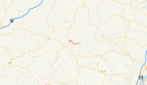
Map of the Catskill Mountains and vicinity with NY 990V highlighted in redRoute information Maintained by NYSDOT Length: 6.15 mi[1] (9.90 km) Major junctions West end:  NY 30 in Gilboa
East end: 
 CR 3 / CR 18 in Conesville
Location Counties: Schoharie Highway system Numbered highways in New York
Interstate • U.S. • N.Y. (former) • Reference • County←  NY 990L
US 1  →
→New York State Route 990V (NY 990V) is a 6.15-mile (9.90 km) long east–west reference route in Schoharie County, New York, United States. The western terminus of the route is at an intersection with NY 30 in Gilboa. Its eastern terminus is at County Route 18 (CR 18) in Conesville, where the road continues east as CR 3. NY 990V is one of four reference routes in New York that has been erroneously signed as a touring route.
NY 990V is a state-maintained remnant of New York State Route 342, a route assigned as part of the 1930 renumbering of state highways in New York. The NY 342 designation was removed in the late 1940s; however, its former routing from Gilboa to Conesville remained a state highway and became NY 990V when the modern reference route system in New York was created.
Contents
Route description
NY 990V begins at an intersection with NY 30 in the town of Gilboa northwest of the Schoharie Reservoir. The route heads northeast around the reservoir to the hamlet of Gilboa, where it crosses Schoharie Creek a short distance downstream from the Gilboa Dam. Outside of Gilboa, NY 990V turns to the southeast and parallels the eastern edge of the reservoir into the town of Conesville. The route remains the primary waterside roadway up to the hamlet of West Conesville, where NY 990V splits from the roadway and enters the Manor Kill Creek valley. The road continues eastward through West Conesville to the hamlet of Conesville, where it becomes CR 3 at an intersection with Champlin Road and Bear Kill Road (CR 18) near the confluence of Manor Kill Creek and the Bear Kill River.[2]
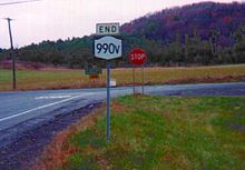 The western terminus of NY 990V at NY 30 in Gilboa.
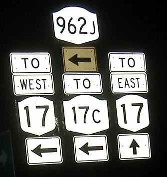
Reference routes in New York are typically not signed with touring route markers, as most are short connector roads or are known by other, more prominent names. However, NY 990V is well-signed, much in the fashion that a minor touring route would be.[3] NY 990V is one of four reference routes in New York that is signed with touring route markers, along with NY 961F,[4] NY 962J[5] and NY 990L.[6]
History
The entirety of NY 990V was originally part of NY 342, a route assigned as part of the 1930 renumbering of state highways in New York. NY 342 began at NY 30 near the hamlet of Gilboa and ended in the Conesville hamlet of Manorkill.[7] By the following year, NY 342 was truncated westward to Conesville while a highway between NY 23 near South Gilboa and NY 30 southwest of Gilboa was designated as NY 297.[8] The NY 297 designation was removed ca. 1936.[9][10] NY 342 was extended westward over the former routing of NY 297 in the mid-1940s[11][12] before it ceased to exist altogether in the late 1940s.[13][14] While the portion west of NY 30 became CR 14, the section east of NY 30 remained state-maintained.[15] When the modern reference route system was created, the Gilboa–Conesville state highway was designated as NY 990V.[16]
Major intersections
The entire route is in Schoharie County.
Location Mile[1] Destinations Notes Gilboa 0.00 NY 30Conesville 6.15 CR 3 / CR 181.000 mi = 1.609 km; 1.000 km = 0.621 mi References
- ^ a b "2008 Traffic Data Report for New York State" (PDF). New York State Department of Transportation. June 16, 2009. p. 372. https://www.nysdot.gov/divisions/engineering/technical-services/hds-respository/NYSDOT_Traffic_Data_Report_2008.pdf. Retrieved December 9, 2009.
- ^ Google, Inc. Google Maps – overview map of NY 990V (Map). Cartography by Google, Inc. http://maps.google.com/maps?sourceid=navclient&ie=UTF-8&rlz=1T4ADBF_enUS232US232&q=from%3A%20RT-990V%20%4042.391287%2C%20-74.460270%20to%3A%20RT-990V%20%4042.386926%2C%20-74.376266&um=1&sa=N&tab=wl. Retrieved May 11, 2008.
- ^ Prince, Adam (October 6, 2006). "Image of NY 990V at Champlain Road". New York Routes. http://www.gribblenation.net/nyroutes/images/photos/routes/990v/990v-01.jpg. Retrieved September 14, 2008.
- ^ Sinsabaugh, Mark (2006). "Image of NY 961F at NY 70". New York Routes. http://www.gribblenation.net/nyroutes/images/photos/routes/961f/961f-00590e.jpg. Retrieved September 14, 2008.
- ^ Alpert, Steve (2006). "Night image of signs along NY 962J". Alps' Roads. http://www.alpsroads.net/roads/ny/ny_434/e962j.jpg. Retrieved September 14, 2008.
- ^ Sinsabaugh, Mark (2007). "Image of a crude NY 990L shield". New York Routes. http://www.gribblenation.net/nyroutes/images/photos/routes/990l/990l-01.jpg. Retrieved September 14, 2008.
- ^ Standard Oil Company of New York (1930). Road Map of New York (Map). Cartography by General Drafting.
- ^ Kendall Refining Company (1931). New York (Map). Cartography by H.M. Gousha Company.
- ^ Sun Oil Company (1935). Road Map & Historical Guide – New York (Map). Cartography by Rand McNally and Company.
- ^ Standard Oil Company (1936). New York (Map). Cartography by General Drafting.
- ^ Esso (1942). New York with Pictorial Guide (Map). Cartography by General Drafting.
- ^ Texaco (1946). New York with Pennsylvania (Map). Cartography by Rand McNally and Company.
- ^ State of New York Department of Public Works. Official Highway Map of New York State (Map). Cartography by General Drafting (1947–48 ed.).
- ^ Esso (1949). New York (Map). Cartography by General Drafting (1950 ed.).
- ^ New York State Department of Transportation (1977). Gilboa Digital Raster Quadrangle (Map). 1:24,000. http://www.nysgis.state.ny.us/gisdata/quads/drg24/dotpreview/index.cfm?code=u43. Retrieved June 2, 2009.
- ^ New York State Department of Transportation (January 2009) (PDF). Official Description of Highway Touring Routes, Bicycling Touring Routes, Scenic Byways, & Commemorative/Memorial Designations in New York State. https://www.nysdot.gov/divisions/operating/oom/transportation-systems/repository/2009%20tour-bk.pdf. Retrieved June 2, 2009.
External links
Categories:- Reference routes in New York
- Transportation in Schoharie County, New York


Wikimedia Foundation. 2010.