- New York State Route 28N
-
NYS Route 28N
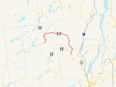
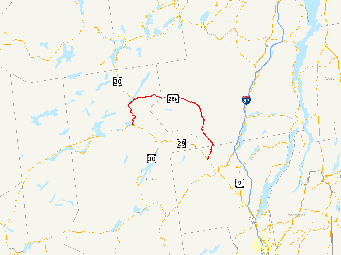
Map of northeastern New York with NY 28N highlighted in redRoute information Auxiliary route of NY 28 Maintained by NYSDOT Length: 50.95 mi[2] (82.00 km) Existed: 1930[1] – present Major junctions West end: 
 NY 28 / NY 30 in Indian Lake
East end: NY 28 in JohnsburgLocation Counties: Hamilton, Essex, Warren Highway system Numbered highways in New York
Interstate • U.S. • N.Y. (former) • Reference • County←  NY 28B
NY 29  →
→New York State Route 28N (NY 28N) is a state highway in the Adirondacks in New York that extends from Blue Mountain Lake to North Creek. The route, 50.95 miles (82.00 km) in length, is a northerly alternate route to NY 28 between both locations. The highway passes through several communities before terminating at Route 28 in North Creek. Over its western end, it undergoes a 10-mile (16 km) concurrency with NY 30 through the town of (named after the lake) Long Lake, where Route 30 splits off, and Route 28N heads eastward through mountainous regions of the Adirondack Park.
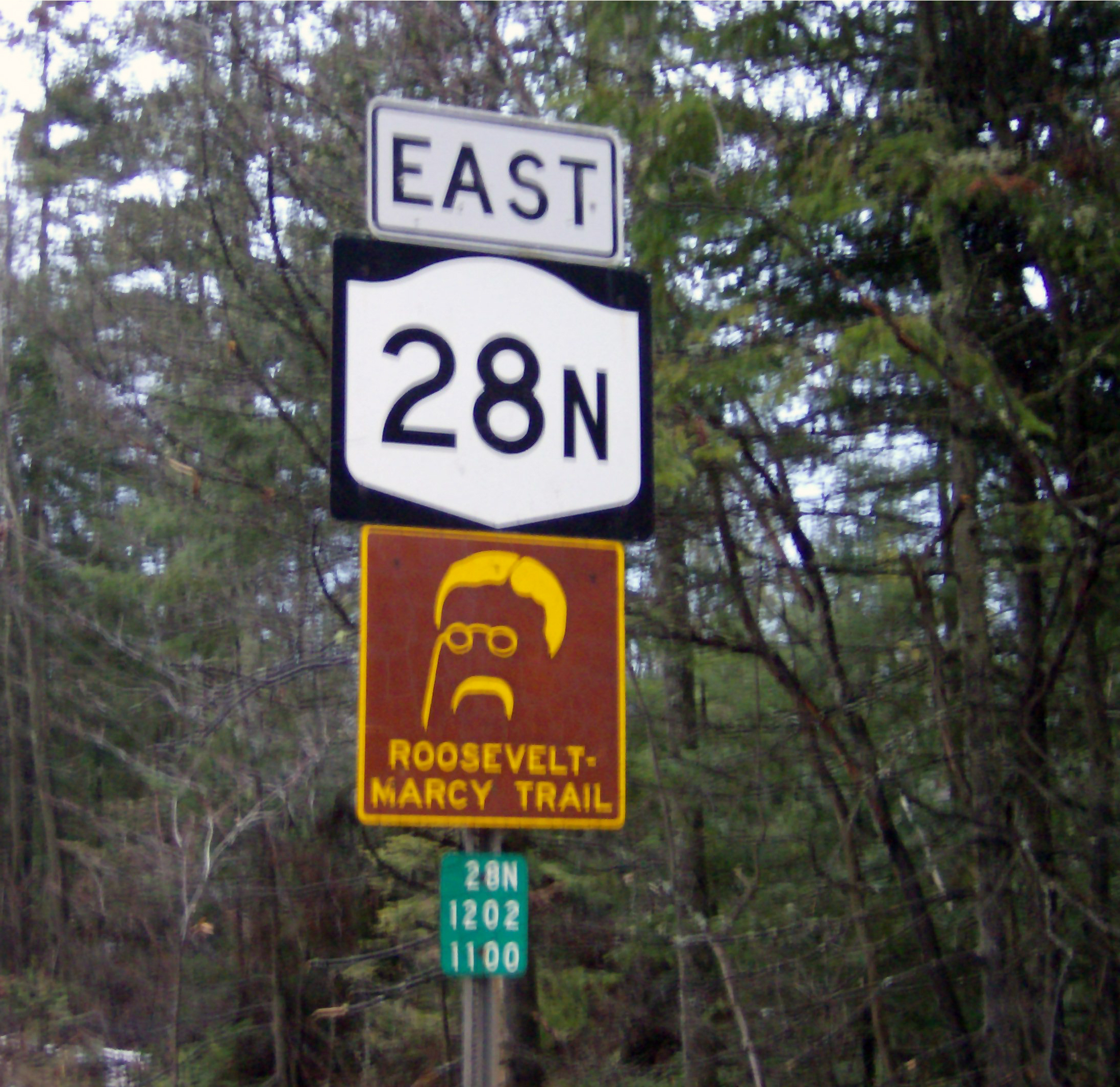
The 40-mile (64 km) section of NY 28N not concurrent with NY 30 is designated as the Roosevelt-Marcy Trail, a scenic byway named for Theodore Roosevelt, who was then the Vice President of the United States. The byway marks the path Roosevelt took in 1901 to reach North Creek from Mount Marcy after learning that President William McKinley had been assassinated. The route has a rather scant history before its designations. The road originated as an old highway stretching from Warren County to Long Lake. It was used for transportation in the iron ore industry in Newcomb, and for the lumber industry in Minerva. New York State gained control of the road in 1909. The Route 28N designation was assigned as part of the 1930 renumbering, incorporating part of pre-1930 Route 10.
Contents
Route description
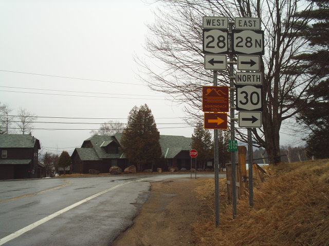
 NY 28N's western terminus viewed from the intersection with NY 28 and NY 30 in Blue Mountain Lake
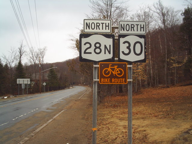
NY 28N begins at the intersection with NY 28 and NY 30 near the hamlet of Blue Mountain Lake within the town of Indian Lake.[3] The highway, concurrent with Route 30, heads north through the hamlet nestled at the base of Blue Mountain, one of the highest peaks in Adirondack Park standing, 3,795 feet (1,157 m) above sea level.[4][5] Routes 28N and 30 track north, gaining elevation after leaving Blue Mountain Lake. Nestled between Blue Mountain and Peaked Mountain, Routes 28N and 30 turn northeast. After intersecting Salmon Pond Road, the highways wind through the mountains and hills of the Adirondacks. Mud Pond and South Pond are on the west, and East Inlet Mountain is on the east. After paralleling Long Lake and the base of East Inlet Mountain, the highways enter the hamlet of Long Lake, where they split. Route 30 heads northwest, while Route 28N turns eastward towards Newcomb.[6][7]
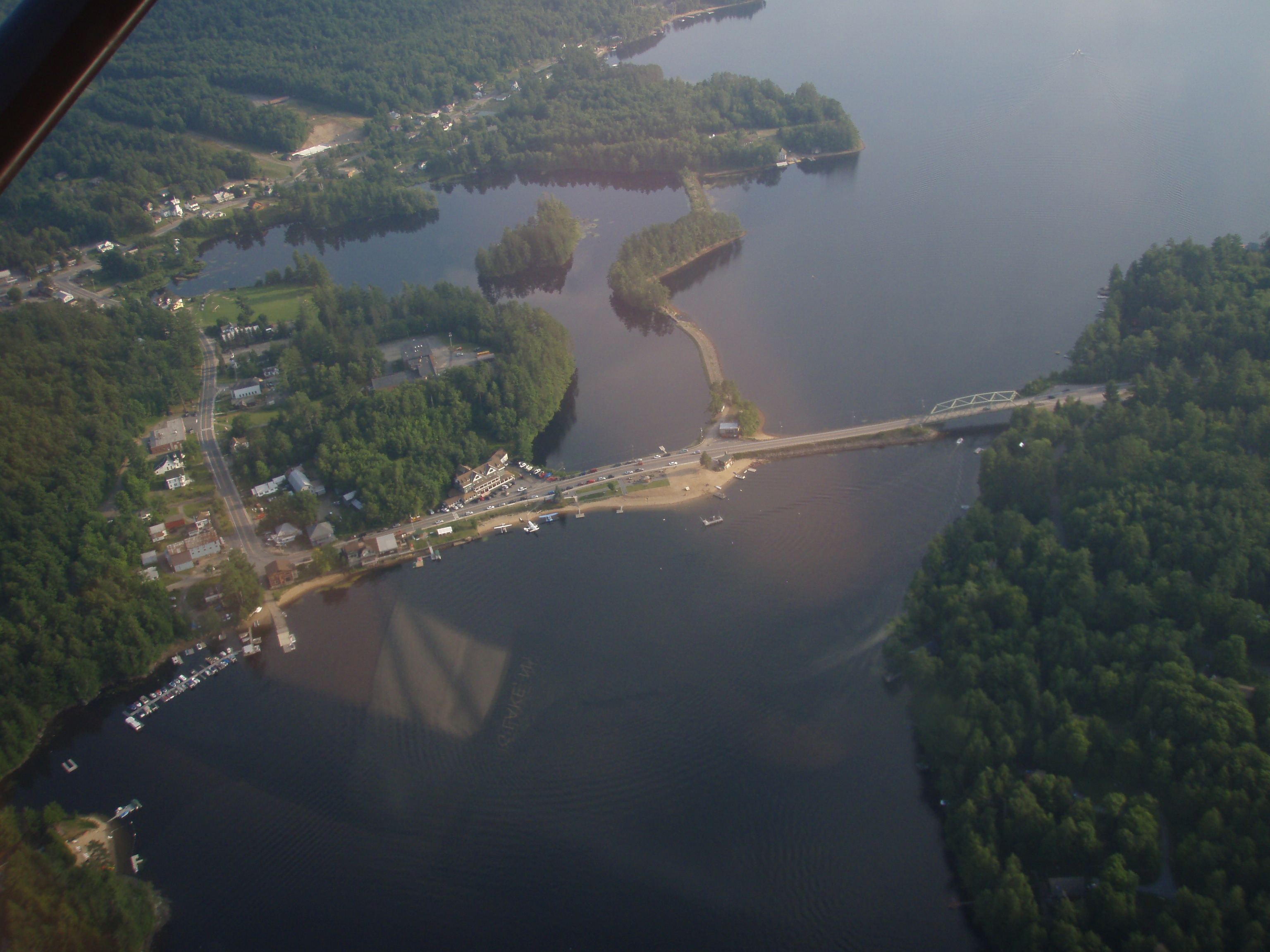
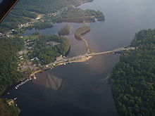 Long Lake from the air. NY 28N is visible near the patch of forests to the west
Beyond Long Lake, Route 28N partially remains in a mountainous region; Pinnacle Mountain, a 2,159 feet (658 m) peak,[8] rises to the north, while lowlands lie to the south.[7] The highway progresses eastward, passing Windfall Mountain and proceeding through the center of the park. Route 28N crosses into Essex County, where it becomes the Roosevelt-Marcy Trail, one of 13 scenic byways in the Adirondack Park.[9] The highway, first turning southeast for a short distance, turns east again, passing south of Rich Lake. The two-lane highway passes Baldwin Mountain[10] to the north, and subsequently enters Newcomb, an isolated town between Long Lake and North Creek. The highway exits Newcomb as it approaches the shores of Harris Lake.[11] After crossing one of those creeks, the highway turns to the southeast and into Winebrook Hills.[12]
 Route 28 heading northbound along Route 30 in Blue Mountain Lake
Route 28N passes through Winebrook Hills,[12] and intersects with its first signed roads since Long Lake, County Route 75 (CR 75, named Eaton Lane) and CR 84 (Blue Ridge Road).[13] The latter is a former alignment of NY 73.[14] Nearby is Vanderwhacker Mountain, a 3,386-foot (1,032 m) high peak and part of the Vanderwhacker Mountain Wild Forest, which the highway passes through.[15] CR 84 eventually parallels the highway to the north of Route 28N, but this slowly begins to change as the main highway begins to progress southward. Route 28N heads south into the hamlet of Aiden Lair and continues south towards Warren County. The highway crosses Boreas Creek, which flows southwest in the park,[13] and eventually passes a series of lakes. Route 28N enters Minerva, where it intersects several county routes, including Route 29, which heads towards the Warren County border and Interstate 87 (I-87).[16]
The road, after leaving Minerva, passes Moxham Mountain, a 2,200-foot (670 m) peak,[16] and eventually crosses the Hudson River. The route ends just after entering North Creek in Warren County, at the intersection with NY 28, its parent route.[17]
Route 28N is classified as a rural major collector road, with the exception of the section that is overlapped with Route 30, which is classified as a rural minor arterial road. As of 2006, the Route 30 overlap had an average annual daily traffic of 1,781 vehicles. Traffic volumes are reduced to 1,231 vehicles per day from the end of the Route 30 overlap to the intersection with Blue Ridge Road (CR 84). South of this intersection, traffic is reduced further to 350 until the hamlet of Minerva, rising to 751 south of Minerva until near the Warren county line. Traffic increases back up to 1,248 vehicles per day from there to Route 28 in North Creek.[18]
History
Early history: Newcomb and Minerva
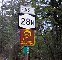 Sign for Route 28N with secondary sign for Roosevelt-Marcy Trail
Many of the earliest roads in the area crossed through Minerva. The first known road that reached the settlement was established in 1804, when land along a highway from Saint Lawrence County to the town of Chester in Warren County, was populated by the West family. Minerva was mainly limited to the vicinity of the old highway, but as more people settled along the road, the town began to grow. For a time, the town boasted several water-powered sawmills, and the highway was used to transport lumber.[19] However, the lumber industry began to fail,[20] and by 1840, the logging and lumber system had been replaced by crops. The town initiated river drives, which continued until 1950.[20]
On March 15, 1828, part of Minerva and nearby Moriah was split into the town of Newcomb. Settlers began to arrive in this area in 1816. Settlement began along the shores of Lake Harris and Newcomb Lake, mainly along the old highway from Warren County to nearby Long Lake. Eventually, highways helped the town grow, and it reached a population of 300 by the 1880 census. The iron ore industry contributed to population growth via 30-mile (48 km) to 40-mile (64 km) roads to Lake Champlain that were meant for hauling ore.[19] The highway from Warren County to Long Lake became part of the state system as early as 1909.[21] After 1845, Newcomb's iron ore industry began to decline and the town evolved into somewhat of a sportsmen's resort. As a result, a road was built connecting Newcomb with nearby Minerva and Long Lake.[22]
The 40-mile (64 km) section of 28N between Long Lake and North Creek is a scenic byway named the Roosevelt-Marcy Trail.[23] This was the route traveled on September 10, 1901 by Theodore Roosevelt, then Vice President of the United States. The vice president had hiked to the summit of nearby Mount Marcy earlier, while there, learned that President William McKinley, having been shot four days earlier by anarchist Leon Czolgosz in Buffalo, was near death. Roosevelt took an overnight wagon ride to North Creek. From the train station there, he traveled to Buffalo, where, after McKinley died, he was sworn in as president on September 14.[24]
Designation and bridge rehabilitation
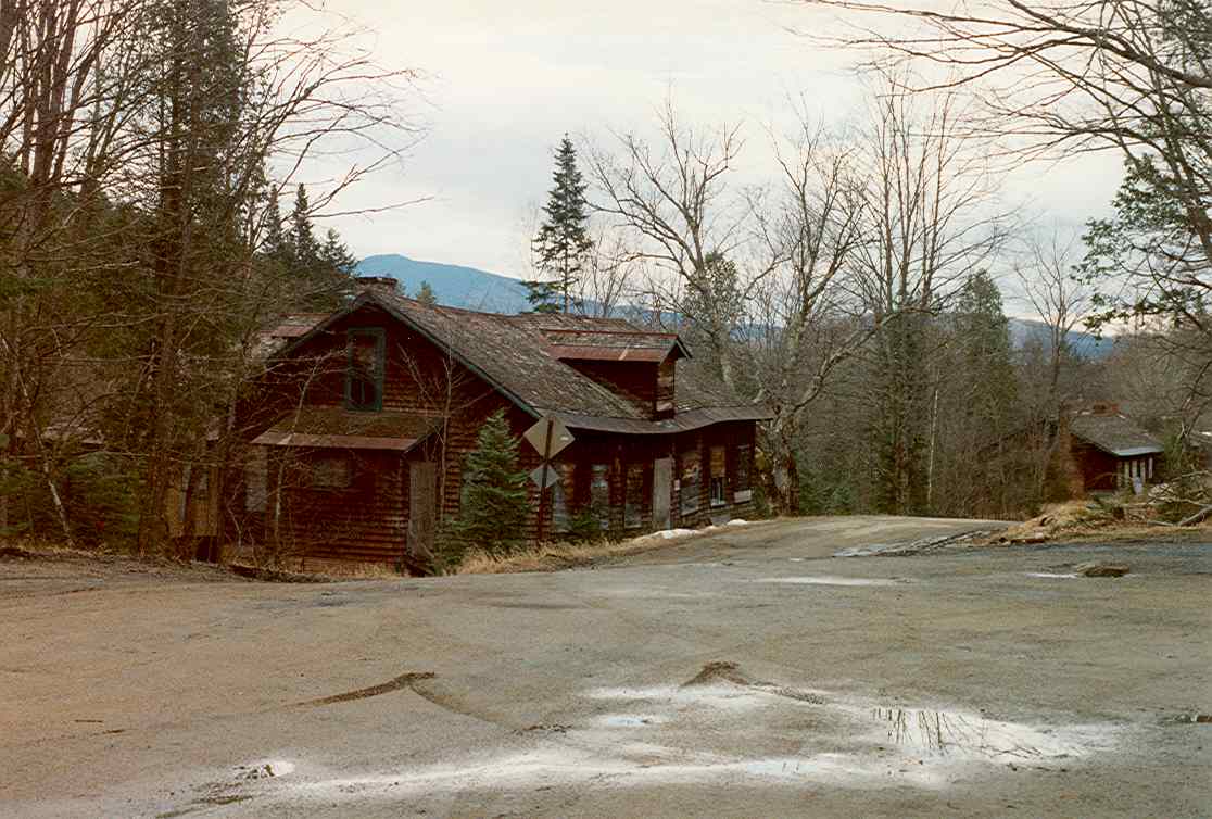
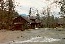 The area now of Tahawus, New York in 1994. This was a location for an intersection with NY 73
The routing of Route 28N was originally designated, but not signed,[A 1] as part of legislative Route 25 in 1908.[25] In 1924, the portion of Route 25 from Long Lake to North Creek was designated as part of the signed NY 10.[26] The segment of former Route 25 between Blue Mountain Lake and Long Lake became part of NY 10A in the late 1920s.[1][27] In the 1930 renumbering, the NY 10A designation was eliminated, and NY 10 was rerouted south of Long Lake to follow the modern routing of NY 30 south to Speculator. The former routing of NY 10 between Long Lake and North Creek was then administratively redesignated as NY 28N,[1] which continued southward from Long Lake to Blue Mountain Lake by way of an overlap with NY 10.[28]
The New York State Department of Transportation has scheduled for Route 28N to undergo construction in spring 2013, to rehabilitate the bridge over the Upper Hudson River Railroad. The $5.9 million project is projected to be complete in fall of 2015, and is to be supported by state and federal funds.[29] New York State Department of Transportation has also planned for Route 28N's bridge over Stillwater Brook in Minerva to be replaced with a stronger structure. The development of the project is expected to take place 2014, with bids and construction starting in 2016. The project has been set to end in 2017, and is predicted to cost $1.1 million of federal and state funds.[30]
Major intersections
County Location Mile[2] Destinations Notes Hamilton Indian Lake 0.00 NY 28 / NY 30 southHamlet of Blue Mountain Lake; southern terminus of NY 28N / NY 30 overlap Long Lake 10.61 NY 30 northNorthern terminus of NY 28N / NY 30 overlap Essex Newcomb 29.52  CR 84 (Blue Ridge Road)
Formerly part of NY 73 Minerva 43.39  CR 30 (Morse Memorial Highway)
Warren Johnsburg 50.79 Main Street Hamlet of North Creek; former routing of NY 28 50.95 NY 281.000 mi = 1.609 km; 1.000 km = 0.621 mi Notes
- ^ The road was given a designation, though no actual signs were erected.
References
- ^ a b c Dickinson, Leon A. (January 12, 1930). "New Signs for State Highways". The New York Times: p. 136.
- ^ a b "2008 Traffic Data Report for New York State" (PDF). New York State Department of Transportation. June 16, 2009. pp. 166–167. https://www.nysdot.gov/divisions/engineering/technical-services/hds-respository/NYSDOT_Traffic_Data_Report_2008.pdf. Retrieved July 18, 2009.
- ^ New York State Department of Transportation (1969). Blue Mountain Digital Raster Quadrangle (Map). 1:24,000. http://www.nysgis.state.ny.us/gisdata/quads/drg24/dotpreview/index.cfm?code=j43. Retrieved January 20, 2010.
- ^ United States Geological Survey (1989). Blue Mountain Lake, NY quadrangle (Map). http://www.nysgis.state.ny.us/gisdata/quads/drg24/usgspreview/index.cfm?code=k43074g3. Retrieved September 19, 2008.
- ^ United States Geological Survey (1954). Blue Mountain NY quadrangle (NW quadrant) (Map). Cartography by United States Geological Survey. http://docs.unh.edu/NY/blmt54nw.jpg. Retrieved September 19, 2008.
- ^ United States Geological Survey (1989). Deerland, NY quadrangle (Map). Cartography by United States Geological Survey. http://www.nysgis.state.ny.us/gisdata/quads/drg24/usgspreview/index.cfm?code=k43074h3. Retrieved September 17, 2008.
- ^ a b New York State Department of Transportation (1969). Deerland Digital Raster Quadrangle (Map). 1:24,000. http://www.nysgis.state.ny.us/gisdata/quads/drg24/dotpreview/index.cfm?code=i43. Retrieved January 20, 2010.
- ^ "Pinnacle Mountain, hamilton County, NY". United States Geological Survey. 2008. http://geonames.usgs.gov/pls/gnispublic/f?p=117:2:13117821344648990308::::::YES. Retrieved September 19, 2008.
- ^ "The 13 Scenic Byways of the Adirondack North Country". Adirondack North Country Association. 2008. Archived from the original on May 29, 2008. http://web.archive.org/web/20080529000918/http://www.adirondack.org/visitorresources.php. Retrieved August 27, 2008.
- ^ "Baldwin Mountain, Warren-Essex County, NY". United States Geological Survey. 2008. http://geonames.usgs.gov/pls/gnispublic/f?p=117:2:13117821344648990308::YES::. Retrieved September 19, 2008.
- ^ New York State Department of Transportation (1969). Newcomb Digital Raster Quadrangle (Map). 1:24,000. http://www.nysgis.state.ny.us/gisdata/quads/drg24/dotpreview/index.cfm?code=i45. Retrieved January 20, 2010.
- ^ a b United States Geological Survey (1989). Newcomb-Winebrook Hills, NY quadrangle (Map). Cartography by United States Geological Survey. http://www.nysgis.state.ny.us/gisdata/quads/drg24/usgspreview/index.cfm?code=k43074h1. Retrieved September 17, 2008.
- ^ a b New York State Department of Transportation (1969). Vanderwacker Mountain Digital Raster Quadrangle (Map). 1:24,000. http://www.nysgis.state.ny.us/gisdata/quads/drg24/dotpreview/index.cfm?code=i46. Retrieved January 20, 2010.
- ^ Automobile Legal Association (ALA) (1931). Automobile Green Book, 1931/32 edition. Scarborough Motor Guide Co.
- ^ "Vanderwhacker Mountain Wild Forest". New York State Department of Environmental Conservation. 2008. http://www.dec.ny.gov/lands/22587.html. Retrieved September 19, 2008.
- ^ a b New York State Department of Transportation (1989). Dutton Mountain Digital Raster Quadrangle (Map). 1:24,000. http://www.nysgis.state.ny.us/gisdata/quads/drg24/dotpreview/index.cfm?code=j46. Retrieved January 20, 2010.
- ^ New York State Department of Transportation (1992). North Creek Digital Raster Quadrangle (Map). 1:24,000. http://www.nysgis.state.ny.us/gisdata/quads/drg24/dotpreview/index.cfm?code=k47. Retrieved January 20, 2010.
- ^ "Traffic Data Viewer Application". New York State Department of Transportation. 2006. https://www.nysdot.gov/divisions/engineering/applications/traffic-data-viewer. Retrieved October 28, 2008.
- ^ a b Smith, H.P. (1885). The History of Essex County. D. Mason and Company.
- ^ a b "Minerva, New York". Essex County Historical Society. 2008. http://www.adkhistorycenter.org/esco/tow/minerva.html. Retrieved September 16, 2008.
- ^ New York State Department of Highways. Report of the State Commissioner of Highways Report of the State Commissioner of Highways (Map). p. 509. http://books.google.com/books?id=m9INAAAAYAAJ&pg=RA1-PA509&dq=State+Route+22B,++Ticonderoga&ei=4iGySOm-MYGCywSU8p31Bg.
- ^ "Newcomb, New York". Essex County Historical Society. 2008. http://www.adkhistorycenter.org/esco/tow/newcomb.html. Retrieved September 16, 2008.
- ^ "Roosevelt-Marcy Trail". United States Department of Transportation. 2007. http://www.byways.org/explore/byways/2217/. Retrieved September 14, 2008.
- ^ "Roosevelt received the news that President McKinley had been shot in Buffalo". Theodore Roosevelt Centennial Site. 2008. http://www.trthegreatnewyorker.com/sites/adirondack/mtmarcy.htm. Retrieved August 27, 2008.
- ^ State of New York Department of Highways (1909). The Highway Law. Albany, New York: J. B. Lyon Company. p. 62. http://books.google.com/?id=jZ0AAAAAMAAJ&pg=PA62. Retrieved February 4, 2010.
- ^ "New York's Main Highways Designated by Numbers". The New York Times: p. XX9. December 21, 1924.
- ^ Rand McNally (1926). Rand McNally Auto Road Atlas (eastern New York) (Map). http://www.broermapsonline.org/members/NorthAmerica/UnitedStates/Midatlantic/NewYork/unitedstates1926ra_009.html. Retrieved May 5, 2008.
- ^ Standard Oil Company of New York (1930). Road Map of New York (Map). Cartography by General Drafting.
- ^ "Route 28N over the Upper Hudson River Railroad". New York State Department of Transportation. 2008. https://www.nysdot.gov/portal/pls/portal/MEXIS_APP.WEPIDYNPAGEMULTI.show?p_arg_names=p_pin&p_arg_values=122316. Retrieved September 16, 2008.
- ^ "Route 28N over the Stillwater Brook". New York State Department of Transportation. 2008. https://www.nysdot.gov/portal/pls/portal/MEXIS_APP.WEPIDYNPAGEMULTI.show?p_arg_names=p_pin&p_arg_values=122315. Retrieved September 18, 2008.
External links
- New York Routes – New York State Route 28N
- New York State Highway Termini – New York State Route 28N
- Roosevelt–Marcy Trail (NYSDOT)
- Roosevelt-Marcy Trail - Maps & Directions
 Highways in Essex County, New York
New York State Route 3 • New York State Route 8 • U.S. Route 9 in New York • New York State Route 9N • New York State Route 22 • New York State Route 28N • New York State Route 73 • New York State Route 74 • New York State Route 86
Interstate 87 • New York State Route 185 • New York State Route 192 • New York State Route 373 • New York State Route 431 • New York State Route 910K • New York State Route 910M • New York State Route 912T • New York State Route 913Q • New York State Route 915F • New York State Route 915K
Highways in Hamilton County, New YorkNew York State Route 8 • New York State Route 10 • New York State Route 28 • New York State Route 28N • New York State Route 30
Categories:- State highways in New York
- Transportation in Essex County, New York
- Transportation in Hamilton County, New York
- Transportation in Warren County, New York

Wikimedia Foundation. 2010.