- Moriah, New York
-
For other uses, see Moriah (disambiguation).
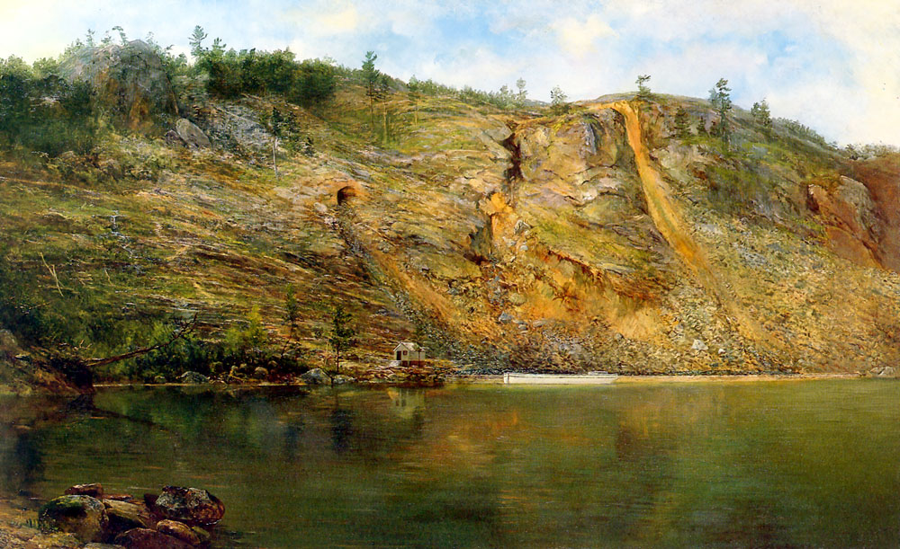
Moriah, New York — Town — The Iron Mine, Port Henry, New York, c. 1862, painted by Homer Dodge Martin Location within the state of New York
 Moriah, New York
Coordinates: 44°3′26″N 73°29′26″W / 44.05722°N 73.49056°W Country United States State New York County Essex Government - Type Town Council - Town Supervisor Thomas R. Scozzafava (R) - Town Council Members' ListArea - Total 71.2 sq mi (184.3 km2) - Land 64.7 sq mi (167.5 km2) - Water 6.5 sq mi (16.7 km2) Elevation 991 ft (302 m) Population (2000) - Total 4,879 - Density 75.4/sq mi (29.1/km2) Time zone Eastern (EST) (UTC-5) - Summer (DST) EDT (UTC-4) ZIP code 12960 Area code(s) 518 FIPS code 36-48428 GNIS feature ID 0979238 Moriah is a town in Essex County, New York, United States. The population was 4,879 at the 2000 census.
The Town of Moriah is in the eastern part of the county. It is 32 miles (51 km) south-southwest of Burlington, VT, 44 miles (71 km) south of Plattsburgh, 98 miles (158 km) north of Albany, NY, and 101 miles (163 km) south of Montreal, Quebec.[1][2] Moriah is inside the Adirondack Park.
Contents
History
This area was inhabited for thousands of years by varying cultures of indigenous peoples. At the time of European encounter, the area was inhabited chiefly by the historic Iroquoian-speaking Mohawk of the Iroquois Confederacy to the west of Lake Champlain, with Algonquian-speaking Mahican to the south.
In 1749 the French Jesuits attracted numerous Iroquois (mostly Onondaga fleeing warfare in the western part of present-day New York) to a site on the Oswegatchie River near present-day Ogdensburg. The Jesuit fathers founded a mission village and fort. The Iroquois had to convert to Catholicism to live there. The converted Iroquois and their descendants became known as the Oswegatchie, and were considered "nephews" to the Six Nations of the Iroquois. They were among the Seven Nations of Canada that allied with the French during the Seven Years War and with the British during the American Revolutionary War, in part due to their strong trading ties and cultural links.[3] After the Seven Years War (French and Indian War) and British victory, the colonial government granted some of its soldiers land in the region, which was ceded by the French.
It was not until after the American Revolutionary War, when most of the Iroquois allies went to Upper Canada with the Loyalists, that the first European-American permanent settlement was made, around 1785. At the time, local Native Americans still hunted in the area. They were called the St. Regis and Oswegatchie Indians, although both groups were Catholic Iroquois.[4] Relations were initially friendly, but American settlement patterns pushed the Native Americans from their hunting grounds. (The St. Regis group were Catholic Mohawk who lived at the reserve of Akwesasne, whose territory along the St. Lawrence River included land within the boundaries of both Canada and New York, recognized as the present-day St. Regis Mohawk Reservation.)[5]
The town was formed in 1808 from the Town of Elizabethtown.
The discovery and mining of iron in the Adirondacks caused a boom in the local economy. This area also processed iron in smelting, and shipped products from Port Henry on Lake Champlain. These operations were conducted from 1824 until 1971. The Iron Center Museum in Port Henry recalls and interprets that past era.[4]
Winter ice-fishing for Smelt on the frozen Lake Champlain has been a popular sport for more than a century. Tourists come to join the residents in this activity.
Geography
According to the United States Census Bureau, the town has a total area of 71.2 square miles (184 km2), of which, 64.7 square miles (168 km2) of it is land and 6.5 square miles (17 km2) of it (9.09%) is water.
The east town line is formed by Lake Champlain and the border of Vermont.
New York State Route 9N is a north-south highway near Lake Champlain. Interstate 87, The Northway, crosses the northwest corner of Moriah.
Demographics
As of the census[6] of 2000, there were 4,879 people, 1,894 households, and 1,253 families residing in the town. The population density was 75.4 people per square mile (29.1/km²). There were 2,253 housing units at an average density of 34.8 per square mile (13.4/km²). The racial makeup of the town was 94.71% White, 2.79% African American, 0.20% Native American, 0.47% Asian, 0.06% Pacific Islander, 1.21% from other races, and 0.55% from two or more races. Hispanic or Latino of any race were 3.30% of the population.
There were 1,894 households out of which 29.0% had children under the age of 18 living with them, 50.8% were married couples living together, 10.2% had a female householder with no husband present, and 33.8% were non-families. 28.5% of all households were made up of individuals and 13.9% had someone living alone who was 65 years of age or older. The average household size was 2.40 and the average family size was 2.91.
In the town the population was spread out with 22.5% under the age of 18, 9.4% from 18 to 24, 29.3% from 25 to 44, 21.9% from 45 to 64, and 16.9% who were 65 years of age or older. The median age was 38 years. For every 100 females there were 110.9 males. For every 100 females age 18 and over, there were 111.5 males.
The median income for a household in the town was $31,903, and the median income for a family was $39,827. Males had a median income of $31,747 versus $21,592 for females. The per capita income for the town was $19,721. About 8.5% of families and 12.8% of the population were below the poverty line, including 17.4% of those under age 18 and 7.0% of those age 65 or over.
Communities and locations in Moriah
- Bartlett Pond - A pond by the north town line, northeast of Mineville.
- Bulwagga Bay - A bay of Lake Champlain, southeast of Port Henry.
- Grover Hills - A hamlet north of Moriah Center on County Road 7.
- Moriah - The hamlet of Moriah is west of Port Henry village on County Road 42 at the junction of County Road 7.
- Moriah Center - A hamlet north of Moriah on County Road 7 at County Road 4.
- Mineville - A hamlet northeast of Witherbee on County Road 6.
- Mullen Bay - A bay of Lake Champlain north of Port Henry by the north town line.
- Port Henry – The Village of Port Henry on the shore of Lake Champlain.
- Witherbee - A hamlet near the north town line on County Road 7 (birthplace of Johnny Podres).
- Cheever - An area of Port Henry located North of the Village along route 9n on the way to Westport.
- Moriah Corners - A small hamlet, similar to Moriah Center in that it is based around a four way intersection and a few small locally owned businesses.
Notable residents
- Johnny Podres, Brooklyn Dodgers pitcher and 1955 World Series MVP. Born in Witherbee.
- John Tarbell, (b. in Moriah, lieutenant-colonel of the 91st New York Volunteer Infantry Regiment and promoted to brevet brigadier general of United States Volunteers during the American Civil War.[7] In 1865 he resigned from the Army and bought a plantation in Scott County, Mississippi, and settled with his family in Atlanta to do business. On March 4, 1866, he testified before the US Congress and the Joint Committee on Reconstruction, saying the quality of leadership was integral to its success.[8]
- Tom Tyler, early 20th-century film star.
- Robert Garrow, serial killer who murdered several women in the Syracuse area in 1973.
References
- ^ Wolfram Alpha, Moriah, NY
- ^ Wolfram Alpha, distance from Plattsburgh, NY to Moriah, NY
- ^ John A. Dickinson, "La federation des sept feux de la Vallee du Saint-Laurent: XVIIe-XIXe siecle by Jean-Pierre Sawaya. [review]", The American Historical Review, Vol. 105, No. 1 (Feb., 2000), pp. 202-203
- ^ a b "Moriah, NY", Essex County Historical Society, Adirondack History Center Museum, accessed 31 January 2011
- ^ Darren Bonaparte, "The Seven Nations of Canada: The Other Iroquois Confederacy", The Wampum Chronicles, accessed 2 January 2009
- ^ "American FactFinder". United States Census Bureau. http://factfinder.census.gov. Retrieved 2008-01-31.
- ^ "Edgar Tarbell Ensign", History of Colorado, Vol. 4, edited by Wilbur Fiske Stone, The S. J. Clarke publishing company, 1919, p. 523, accessed 31 January 2011
- ^ "Joint Committee on Reconstruction, Brevet Brigadier General John Tarbell: The South has Grounds for Complaint", Report of the Joint Committee on Reconstruction of the First Session Thirty-Ninth Congress, Government Printing Office, Washington, 1866, "Georgia - Alabama - Mississippi - Arkansas", pp. 155-157, accessed 31 January 2011
Further reading
- D. Peter MacLeod's notes on the Treaty of Kahnawake, 1760
- D. Peter McLeod, (1996) The Canadian Iroquois and the Seven Years' War, Ottawa & Toronto: The Canadian War Museum & Dundurn Press. Canadian War Museum Historical Publication No. 29.
- D. Peter McLeod, Northern Armageddon: the Battle of the Plains of Abraham, Vancouver: Douglas & McIntyre, 2008.
- Jack Campisi and William A. Starna. "On the Road to Canandaigua: The Treaty of 1794", American Indian Quarterly, Vol. 19, No. 4 (Autumn, 1995), pp. 467–490
External links
- Town of Moriah, Official Website
- "Moriah, NY", Essex County Historical Society, Adirondack History Center Museum
Coordinates: 44°02′46″N 73°30′18″W / 44.04611°N 73.505°W
Municipalities and communities of Essex County, New York County seat: Elizabethtown Towns Chesterfield | Crown Point | Elizabethtown | Essex | Jay | Keene | Lewis | Minerva | Moriah | Newcomb | North Elba | North Hudson | Schroon | St. Armand | Ticonderoga | Westport | Willsboro | Wilmington
Villages Keeseville‡ | Lake Placid | Port Henry | Saranac Lake‡
CDPs Other
hamletsFootnotes ‡This populated place also has portions in an adjacent county or counties
Categories:- Towns in New York
- Populated places in Essex County, New York


Wikimedia Foundation. 2010.