- New York State Route 418
-
NYS Route 418

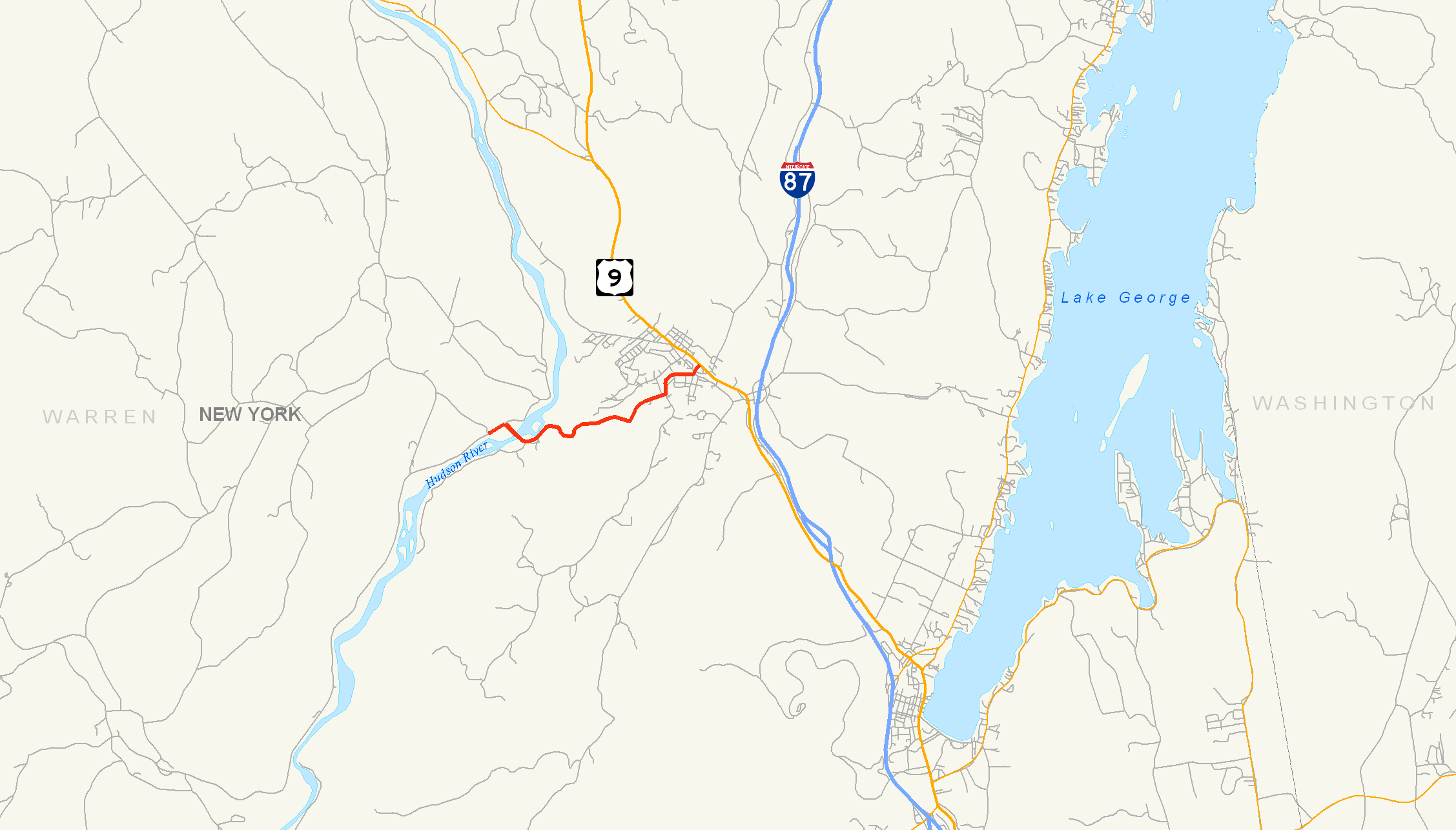
Map of the Warrensburg area with NY 418 highlighted in redRoute information Maintained by NYSDOT Length: 3.50 mi[2] (5.63 km) Existed: 1930[1] – present Major junctions West end: Athol Road in Thurman East end:  US 9 in Warrensburg
Location Counties: Warren Highway system Numbered highways in New York
Interstate • U.S. • N.Y. (former) • Reference • County←  NY 417
NY 419  →
→New York State Route 418 (NY 418) is a 3.50-mile (5.63 km) state highway located entirely within the Adirondack Park in Warren County, New York, United States. The route begins just west of the hamlet of Thurman Station, where Athol Road changes designations from County Route 4 (CR 4) to NY 418. It heads eastward through the towns of Thurman and Warrensburg, following the Schroon River to an intersection with U.S. Route 9 (US 9) in the hamlet of Warrensburg. All of NY 418 is part of the Dude Ranch Trail, a New York State Scenic Byway that runs through Warren County and Saratoga County.
The origins of NY 418 date back to the 19th century when Thurman Station and Warrensburg were first connected by way of a road. This highway was reconstructed by the state of New York during the early 1910s and added to the state highway system in 1915. It was designated as NY 418 as part of the 1930 renumbering of state highways in New York. The highway has remained mainly unchanged since, save for the replacement of its bridges over the Schroon and the Hudson Rivers in the 1930s and 1940s, respectively.
Contents
Route description
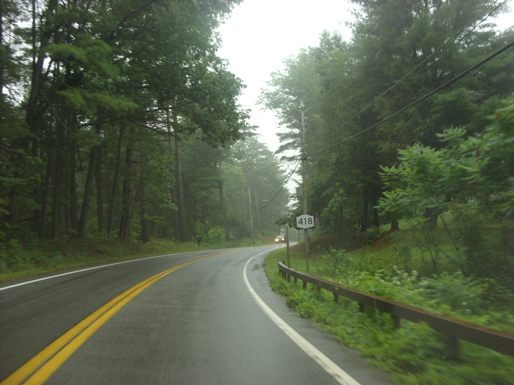
 NY 418 heading eastbound through a forest outside of Warrensburg
NY 418 begins just southwest of Thurman Station, a hamlet within the town of Thurman, where Athol Road shifts from county maintenance (as the unsigned CR 4) to state maintenance (as NY 418). It heads northeastward along the base of Sugarloaf Mountain, one of the Three Sisters Mountains, as it passes an area with very little development. The route continues along a northeasterly trek to Thurman Station, where it intersects with River Road in the center of the isolated community. At this point, the route turns southeastward and crosses the Upper Hudson River Railroad at-grade before passing over the Hudson River on the Thurman Station Bridge. NY 418 passes into the town of Warrensburg at the midpoint of the bridge.[3]
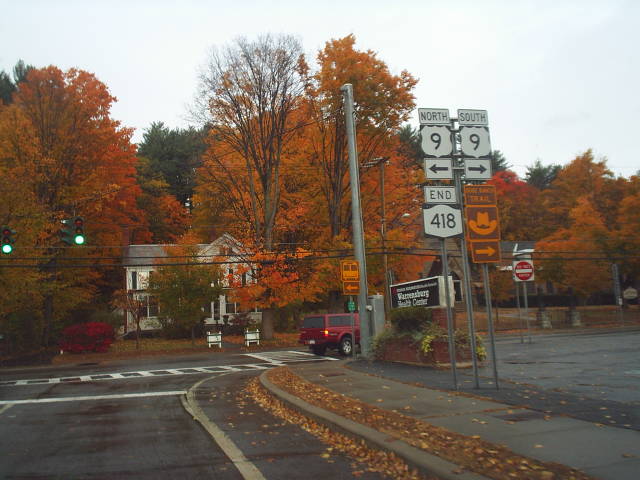
On the opposite riverbank, the route turns eastward to follow the eastern bank of the Schroon River through an undeveloped portion of Warrensburg comprising little more than forests. The route winds along the bank of river to the hamlet of Warrensburg, where the route becomes River Street and heads past several blocks of houses. At Alden Avenue, the route curves to the northeast, mirroring the curvature of the river through Warrensburg. It continues along the waterway to the junction of Ridge and River Streets, where NY 418 turns north onto Richards Avenue and finally crosses the river on a truss bridge. The route meets Water Street (CR 9) on the opposite bank before continuing northward past several commercial properties to the center of Warrensburg, where NY 418 ends at an intersection with US 9.[3]
History
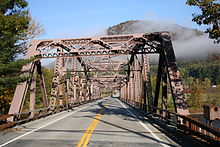 The Thurman Station Bridge over the Hudson River
The origins of NY 418 date back to 1896, by which time a road had been constructed between Thurman Station and Warrensburg.[4] In 1912, the state of New York solicited bids for a project to improve the road to state highway standards. On June 12, 1912, the contract for the project was awarded to the Joseph Walker Construction Company of Albany for $35,776[5][6] (equivalent to $811,498 in 2011).[7] About $3,400 worth of upgrades were made to the highway before the contract was cancelled.[6] The state resolicited bids for the project in February 1914[8] and let a $35,231 (equivalent to $769,932 in 2011) contract for the project on February 20, 1914. The highway was rebuilt as a stone highway bound by asphalt. The upgraded highway was accepted into the state highway system on January 8, 1915.[6][7]
The Thurman Station – Warrensburg state highway was designated as NY 418 as part of the 1930 renumbering of state highways in New York. NY 418's alignment has not been substantially altered since that time;[1] however, parts of the route have been upgraded since 1930. In 1933, the original bridge that carried NY 418 over the Schroon River in Warrensburg was replaced with a new truss bridge 50.3 meters (165 ft) in length.[9] The route's original bridge over the Hudson River near Thurman Station was replaced in 1941 with the Thurman Station Bridge, another truss bridge 133.5 meters (438 ft) long.[10] The bridges were reconstructed by the New York State Department of Transportation in 2000 and 1995, respectively.[9][10]
Parts of NY 418 run through a proposed tourism district known as the First Wilderness Heritage Corridor. The corridor, conceived by Warren County, is intended to revitalize the Hudson River corridor by turning it into a tourist destination. Areas currently being studied for future development include the primarily residential and agricultural areas around Thurman Station, the privately-owned train station along NY 418 in this same area, and two vacant lots adjacent to the Hudson River on NY 418.[11] At some point in time, the entire length of NY 418 was included as part of the Dude Ranch Trail, a New York State Scenic Byway that connects Lake George to the Hudson River.[12]
Major intersections
 The eastern terminus of NY 418 at US 9
The entire route is in Warren County.
Location Mile[2] Destinations Notes Thurman 0.00 Athol Road (CR 4) Town of Warrensburg 3.50 US 9 (Main Street)Hamlet of Warrensburg 1.000 mi = 1.609 km; 1.000 km = 0.621 mi References
- ^ a b Standard Oil Company of New York (1930). Road Map of New York (Map). Cartography by General Drafting.
- ^ a b "2008 Traffic Data Report for New York State" (PDF). New York State Department of Transportation. June 16, 2009. pp. 311–312. https://www.nysdot.gov/divisions/engineering/technical-services/hds-respository/NYSDOT_Traffic_Data_Report_2008.pdf. Retrieved December 9, 2009.
- ^ a b Yahoo! Inc. Yahoo! Maps – overview map of NY 418 (Map). Cartography by NAVTEQ. http://maps.yahoo.com/#mvt=h&lat=43.485785&lon=-73.796095&zoom=15&q1=43.481483%2C-73.823277&q2=43.492723%2C-73.768903. Retrieved December 24, 2009.
- ^ New York State Engineer and Surveyor (1896). Annual Report of the State Engineer and Surveyor of the State of New York. Wynkoop Hallenbeck Crawford Co.. p. 49. http://books.google.com/books?id=UmhKAAAAMAAJ&pg=PA49&dq=Warrensburg+Road&lr=&client=firefox-a. Retrieved December 24, 2009.
- ^ Municipal Engineering. 42. Engineering Publishing Company. 1912. p. 62. http://books.google.com/books?id=cM_NAAAAMAAJ&pg=RA1-PA62&dq=Thurman+Station+road. Retrieved December 24, 2009.
- ^ a b c New York State Department of Highways (1920). Report of the State Commissioner of Highways. Albany, New York: J. B. Lyon Company. pp. 206, 250, 475. http://books.google.com/books?id=Sj4CAAAAYAAJ&pg=PA206. Retrieved December 24, 2009.
- ^ a b Consumer Price Index (estimate) 1800–2008. Federal Reserve Bank of Minneapolis. Retrieved December 7, 2010.
- ^ Good Roads. 7. E. L. Powers Co.. 1914. p. 42. http://books.google.com/books?id=oAsAAAAAMAAJ&pg=RA2-PA12&dq=Thurman+Station+roads. Retrieved December 24, 2009.
- ^ a b Federal Highway Administration (2008). "Structure 1048240". National Bridge Inventory. United States Department of Transportation. http://nationalbridges.com/nbi_record.php?StateCode=36&struct=000000001048240. Retrieved December 24, 2009.
- ^ a b Federal Highway Administration (2008). "Structure 1048230". National Bridge Inventory. United States Department of Transportation. http://nationalbridges.com/nbi_record.php?StateCode=36&struct=000000001048230. Retrieved December 24, 2009.
- ^ Warren County, New York. "First Wilderness Heritage Corridor Master Plan". http://www.firstwilderness.com/masterplan.php. Retrieved December 24, 2009.
- ^ New York State Legislature. "New York State Highway Law § 342-N". http://public.leginfo.state.ny.us/menugetf.cgi?COMMONQUERY=LAWS. Retrieved December 24, 2009.
External links
- New York Routes – New York State Route 418
- New York State Highway Termini – New York State Route 418
Categories:- State highways in New York
- Transportation in Warren County, New York


Wikimedia Foundation. 2010.