- Pennsylvania Route 32
-
"PA 32" redirects here. PA 32 may also refer to Pennsylvania's 32nd congressional district or the Piper Cherokee Six.
PA Route 32
Route information Maintained by PennDOT Length: 38 mi[1] (61 km) Existed: 1928[1] – present Major junctions South end:  US 1 in Morrisville
 I-95 north of Yardley
 US 202 north of New Hope
North end:  PA 611 near Upper Black Eddy
Location Counties: Bucks Highway system Roads in Pennsylvania
Interstate • US • State • Legislative←  PA 31
PA 31PA 33  →
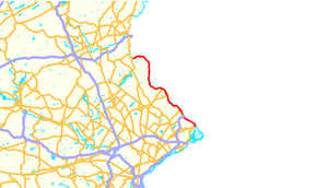
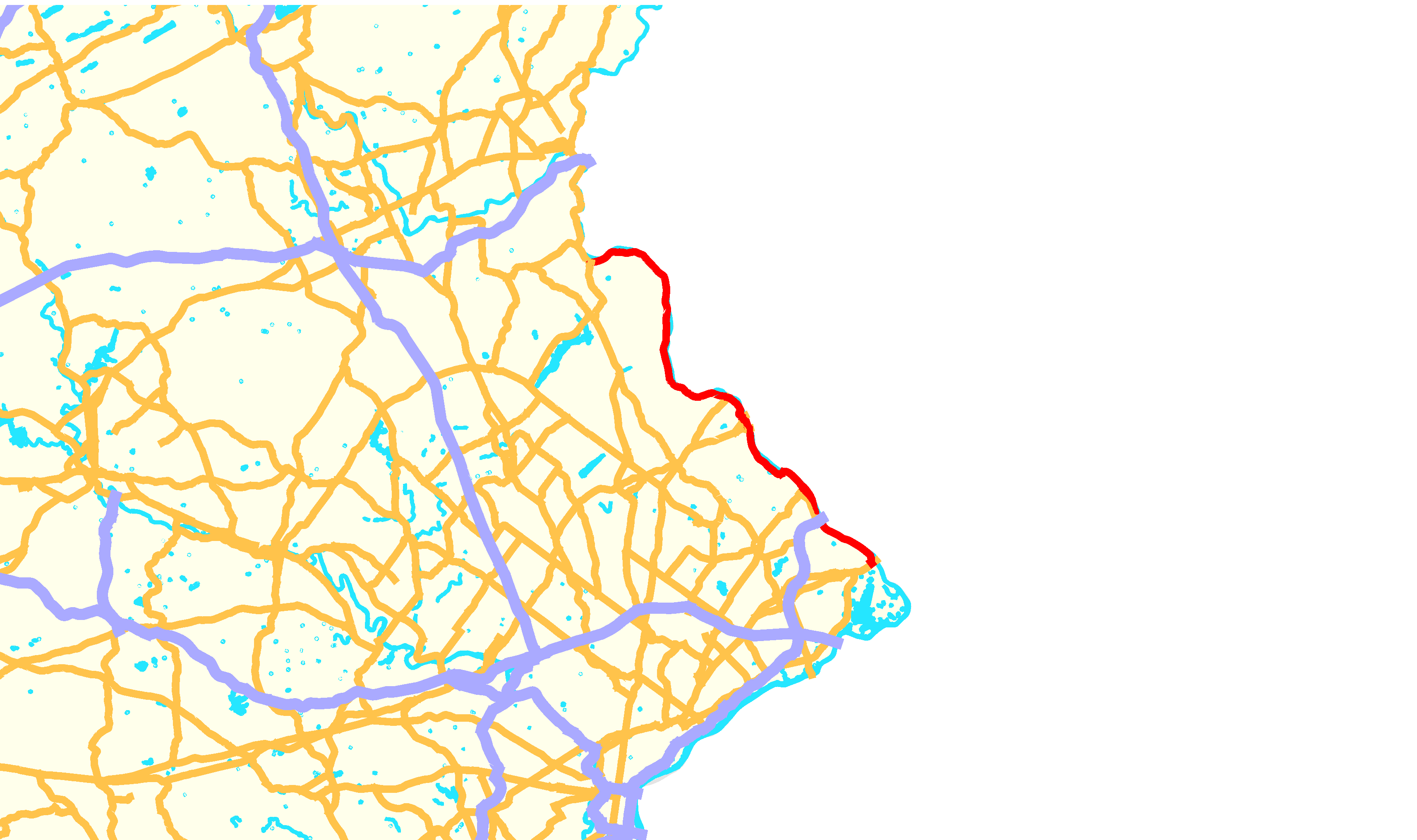
→Pennsylvania Route 32 is a scenic two-lane highway that runs along the side of the Delaware River in Bucks County, Pennsylvania. It begins at U.S. 1 in Falls Township and ends at Pennsylvania Route 611 near the village of Kintnersville. Most notably it passes through Washington Crossing Historic Park, a Revolutionary War-themed historical park on the site of George Washington's Christmas 1776 crossing. It also passes through the towns of Yardley and New Hope.[2]
For most of its length the speeds are reduced to 35 mph (56 km/h), although there are sections of 45 mph. As such, it is more of a scenic river route than a highway and most motorists in Bucks County use parallel roads in that area. It is known as River Road throughout its length. The road is popular for Sunday drivers, bikers, fishermen, and viewers of fall foliage.[3]
Contents
Route description
Route 32 begins at an incomplete interchange with U.S. Route 1 in Falls Township, 26 miles (42 km) northeast of Philadelphia. The highway enters the borough of Morrisville from the west as Bridge Street parallel to US 1. One mile east of the termini, Route 32 intersects Pennsylvania Avenue; motorists use this street to enter the US 1 expressway. Route 32 east of Pennsylvania Avenue turns north on to Delmorr Avenue and is parallel to the Delaware River. While parallel to the Delaware River, the highway intersects many bridges, two of which, US 1 and US 202, are one way toll into Pennsylvania from New Jersey. Outside of Morrisville, the highway continues its north alignment heading to the north and west.
While traversing Yardley, Route 32 is called Delaware Avenue and meets the eastern terminus of PA Route 332. North of the borough, the highway is known as River Road and passes under Interstate 95. North of the I-95 underpass, the road is parallel to the Delaware River and Pennsylvania Canal. In the town of Washington Crossing, the route traverses Washington Crossing Historic Park, the site where George Washington's troops crossed the Delaware River during the Revolutionary War. Route 32 meets PA Route 532 in downtown Washington Crossing. North of the park, the route travels on a north alignment with a couple of curves.
Route 32 enters New Hope from the south as Main Street, upon briefly intersecting the northern terminus of PA Route 232. The highway later intersects PA Route 179: another route that terminates at the New Jersey state line. North of New Hope, Route 32 interchanges with U.S. Route 202. In Centre Bridge, Route 32 meets the northern terminus of PA Route 263. The continues to curve along the Delaware River north of PA 263. The rest of the designation of Route 32 is parallel to the Delaware River. The highway terminates at junction with PA Route 611 in Nockamixon Township.[2]
History
Pennsylvania Route 32 was designated along its current alignment in 1928.[1] The original alignment, created in 1925, followed the same route but continued south from Morrisville to Philadelphia. The PA 32 designation between Morrisville and Philadelphia was removed in favor of U.S. Route 13 in 1928.[4] In 1932 a parkway was proposed along the route from Morrisville to New Hope, however, it was never built. In 1969, another proposal was created for a $30 million Pennsylvania Route 32 expressway from I-95 near Yardley to US 202 in New Hope. However, the proposal was canceled in 1974 due to low traffic volume and environmental issues.[5]
Flooding
Due to its route along the Delaware River, Route 32 is prone to floods. Several floods, including the Mid-Atlantic Flood of June 2006, left many parts of the road impassable. The sections of road between PA 263 and Greenhill Road and near Fleecydale Road in Solebury Township and between PA 611 and Narrows Hill Road in Nockamixon Township were closed from the damage. The Pennsylvania Department of Transportation undertook a $11.4 million[3] project to fix these sections of road in 2008. The section between PA 263 and Greenhill Road was completed by Memorial Day 2008 and the section between PA 611 and Narrows Hill Road was completed in summer of 2008.[3] Road closures and detours have affected many businesses along Route 32, with many seeing a decline in customers and some closing down or being put up for auction.[6] However, the once-closed part of the far northern terminus in Nockamixon Township has been completed, and is now open for both northbound and southbound travelers.
Major intersections
The entire route is in Bucks County.
Location Mile[7] Destinations Notes Falls Township 0.00  US 1 south / US 13 – Philadelphia, Bristol, Yardley
Interchange Morrisville Bridge Street Former US 1 north Trenton Avenue, Calhoun Street Bridge Yardley 5.52  PA 332 west (Afton Avenue)
Upper Makefield Township 9.50  PA 532 south to I-95 / Washington Crossing Bridge – Newtown
New Hope 16.27  PA 232 south (Windy Bush Road) – Richboro
16.77  PA 179 (Bridge Street, New Hope-Lambertville Bridge)
Solebury Township 17.90 US 202 (New Hope-Lambertville Toll Bridge) – New JerseyInterchange 20.14 
 PA 263 south (Upper York Road) to Route 29 (via Centre Bridge-Stockton Bridge) – Buckingham, Stockton
Tinicum Township Uhlerstown-Frenchtown Bridge Bridgeton Township Upper Black Eddy-Milford Bridge Nockamixon Township 40.56 PA 611 (Easton Road)References
- ^ a b c Pennsylvania Highways - Pennsylvania Route 32
- ^ a b "Pennsylvania Official Tourism and Transportation Map 2006" (PDF). PennDOT. ftp://ftp.dot.state.pa.us/public/pdf/BPR_PDF_FILES/MAPS/Statewide/otm/2006/otm_2006.PDF. Retrieved 2007-04-21.
- ^ a b c Ruvo, Christopher. "Roadwork in Progress" The Intelligencer, March 23, 2008
- ^ The US Highway System and Numbering – The Pennsylvania State Route Numbering System – Central PA/MD Roads URL accessed 3 July 2008
- ^ PA 32 Expressway (unbuilt) URL accessed 31 March 2008
- ^ Bentman, Hilary. "18 months later, flood continues bashing business" The Intelligencer, December 11, 2007
- ^ DeLorme Street Atlas USA 2007. Toggle Measure Tool
External links
Road transportation infrastructure of the metro Philadelphia area Interstates U.S. Routes Pennsylvania Routes New Jersey Routes Delaware Routes Named roads/streets Benjamin Franklin Parkway · Broad Street · City Avenue · Front Street · Girard Avenue · Market Street · Roosevelt Boulevard · South Street · Chestnut Street · Walnut Street
Pennsylvania Turnpike · New Jersey Turnpike · Delaware Turnpike · Atlantic City Expressway · Schuylkill Expressway · Delaware Expressway · Blue Route · Vine St Expressway · North South Freeway · Lancaster Avenue · Bethlehem Pike · Baltimore Pike · Black Horse PikeBridges Delaware Memorial Bridge · Commodore Barry Bridge · Walt Whitman Bridge · Ben Franklin Bridge · Betsy Ross Bridge · Tacony–Palmyra Bridge · Burlington–Bristol Bridge · Delaware River – Turnpike Toll BridgeCategories:- State highways in Pennsylvania
- Lincoln Highway

Wikimedia Foundation. 2010.