- Pennsylvania Route 320
-
PA Route 320 Route information Maintained by PennDOT Length: 19 mi[1] (31 km) Existed: 1928 – present Major junctions South end:  PA 291 in Chester
 US 1 in Springfield
 US 30 in Villanova
 I-76 near West Conshohocken
North end:  PA 23 in Upper Merion Township
Location Counties: Delaware, Montgomery Highway system Roads in Pennsylvania
Interstate • US • State • Legislative←  PA 319
PA 321  →
→Pennsylvania Route 320 is a north–south state highway in southeastern Pennsylvania. The southern terminus of the 19-mile (31 km) long route is at PA 291 in Chester. The northern terminus is at PA 23 in Gladwyne.
Before the construction of the toll-free southern portion of Interstate 476 (the "Blue Route"), Route 320 was one of the most heavily traveled north–south routes across Delaware County and served as one of the most common feeder routes southward towards Interstate 95 and northward towards Interstate 76. The opening of the Blue Route has alleviated some congestion on Route 320.
Route 320 follows the Blue Route for much of its length - in fact, the Blue Route passes over or under Route 320 four times: near Swarthmore, at the intersection of Sproul Road and Springfield Road near the Springfield Township/Marple Township border, at the Sproul Road/Conestoga Road intersection in Radnor Township, and near Matsonford Road in Upper Merion township. While the Blue Route has no direct interchange with the road, many of its exits are located short distances from intersections with PA 320.
Contents
Route description
Delaware County
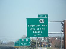
The southern terminus of Route 320 is the intersection of Madison St. and 4th Street (Pennsylvania Route 291) in the City of Chester, Pennsylvania. Madison Street, a one-way northbound street, is signed as Route 320 north to East 8th street, where Route 320 turns left for two blocks along East 8th Street until Avenue of the States. Route 320 then turns right along northbound Avenue of the States for a few more blocks, then after crossing a highway overpass bridge over Interstate 95, Route 320 forks to the right onto Providence Avenue, and Pennsylvania Route 352 continues to the northwest on Edgemont Avenue. Route 320 follows Providence Avenue northward out of the city of Chester, becoming Providence Road, and continues up to the junction of Providence Road and Chester Road. At that junction, Route 320 continues northeastward along Chester Road, while Providence Road continues northwest as Pennsylvania Route 252.
Route 320 continues variously northeastward and northward along Chester Road through the borough of Swarthmore, Pennsylvania, passing the Swarthmore train station and bisecting the campus of Swarthmore College. North of Swarthmore College, Route 320 turns left along Swarthmore Avenue for one block, then right again along Cedar Lane until its junction with Baltimore Pike near Springfield Mall. At this point, Route 320 takes the name Sproul Road and retains this name through various turns at intersections. It continues northward across Baltimore Pike through Springfield Township, passing Springfield Hospital and the Springfield Golf and Country Club, and intersects the northern terminus of Pennsylvania Route 420 (Woodland Avenue). It then intersects U.S. 1 (State Road) at a diamond interchange near the Marple Crossroads Shopping Center, then passes northward into Marple Township.
After crossing over Interstate 476, Route 320 merges with Springfield Road and continues northward, still signed as Sproul Road, past Cardinal O'Hara High School and Lawrence Park Shopping Center. In Broomall, a community in Marple Township, Route 320 turns right at the Marple Public Library and continues northeastward across West Chester Pike (Pennsylvania Route 3), then turns left at the Marple Presbyterian Church at the western terminus of Marple Road. Route 320 continues northward through a corner of Haverford Township, intersecting the western terminus of Darby Road, and then heads into Radnor Township, passing the Overbrook Golf Club and Radnor Valley Country Club. It then intersects Conestoga Road near the Radnor Friends Meetinghouse underneath Interstate 476. Route 320 then continues northeastward to a junction with Spring Mill Road, and continues signed as Spring Mill Road across Lancaster Avenue (U.S. Route 30), bisecting the campus of Villanova University. Route 320 then passes northeastward across County Line Road, passing out of Delaware County and into Lower Merion Township in Montgomery County.
Montgomery County
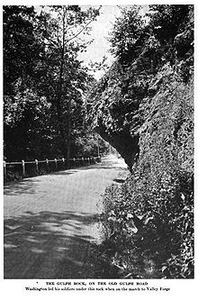
Hanging Rock on Route 320 in Gulph Mills, c. 1919
One block after County Line Road, Route 320 turns left onto Montgomery Avenue, and continues along Montgomery Avenue until Matsonford Road, where the Matsonford SEPTA station is located. The road then changes names to South Gulph Road and continues into Upper Merion Township. It heads northward through the village of Gulph Mills, past a large historic rock, and then intersects the Schuylkill Expressway (Interstate 76). After this intersection, Route 320 continues northeastward along Trinity Road, Holstein Road, and Swedeland Road until its northern terminus at Pennsylvania Route 23 (Schuylkill River Road) near the Schuylkill River north of West Conshohocken.
Major intersections
County Location Mile[2] Destinations Notes Delaware Chester 0.0  PA 291 (Fourth Street)
0.3  US 13 (Ninth Street)
0.6  PA 352 (Avenue of the States)
Southern terminus of concurrency and PA 352 0.65  I-95
I-95Exit 6 on I-95 0.7  PA 352 (Edgmont Avenue)
Northern terminus of concurrency 1.3 SR 2006 (MacDade Boulevard) Formerly PA 520[3] Nether Providence Township 2.2  PA 252 (Providence Road)
Southern terminus of PA 252 Swarthmore 4.7 SR 2016 (Baltimore Pike) Formerly PA 12.[4] Springfield Township 6.2  PA 420 (Woodland Avenue)
Northern terminus of PA 420 7.0  US 1 (State Road)
Interchange Marple Township 7.2 SR 1008 (Old Marple Road) Formerly a part of PA 927.[3] 9.7  PA 3 (West Chester Pike)
Radnor Township 14.3  US 30 (Lancaster Avenue)
Montgomery Upper Merion Township 17.4  I-76 (Schuylkill Expressway)
Exit 330 (Gulph Mills) on I-76 18.7  PA 23 (Schuylkill River Road)
1.000 mi = 1.609 km; 1.000 km = 0.621 mi References
- ^ Pennsylvania Highways - Pennsylvania Route 320
- ^ Google Maps. View of PA 320 (Map). Cartography by NAVTEQ. http://maps.google.com/maps?hl=en&q=PA%20320&um=1&ie=UTF-8&sa=N&tab=wl. Retrieved 2008-05-23.
- ^ a b PennDOT (PDF). 1930 state map, front side (Map). ftp://ftp.dot.state.pa.us/public/pdf/BPR_pdf_files/Maps/Statewide/Historic_OTMs/1930fr.pdf. Retrieved 2009-07-12.
- ^ U.S. 22 - The William Penn Highway
Road transportation infrastructure of the metro Philadelphia area Interstates U.S. Routes Pennsylvania Routes New Jersey Routes Delaware Routes Named roads/streets Benjamin Franklin Parkway · Broad Street · City Avenue · Front Street · Girard Avenue · Market Street · Roosevelt Boulevard · South Street · Chestnut Street · Walnut Street
Pennsylvania Turnpike · New Jersey Turnpike · Delaware Turnpike · Atlantic City Expressway · Schuylkill Expressway · Delaware Expressway · Blue Route · Vine St Expressway · North South Freeway · Lancaster Avenue · Bethlehem Pike · Baltimore Pike · Black Horse PikeBridges Delaware Memorial Bridge · Commodore Barry Bridge · Walt Whitman Bridge · Ben Franklin Bridge · Betsy Ross Bridge · Tacony–Palmyra Bridge · Burlington–Bristol Bridge · Delaware River – Turnpike Toll BridgeCategories:- State highways in Pennsylvania
Wikimedia Foundation. 2010.


